


Servicios Personalizados
Revista

Articulo
 Articulo en XML
 Referencias del artículo
 Enviar articulo por email
Indicadores
-
 Citado por SciELO
Links relacionados
-
 Similares en
SciELO
Similares en
SciELO
Compartir

 Permalink
Ameghiniana
versión On-line ISSN 1851-8044
Ameghiniana v.42 n.2 Buenos Aires mar./jun. 2005
Stratigraphic framework of early Pliocene fossil localities along the north bank of the Cimarron River, Meade County, Kansas
James G. Honey 1 , Pablo Peláez-Campomanes 2 and Robert A. Martin 3
1 Geology Section, University of Colorado, Boulder 80309-0315, USA. honeyj@ucsu.colorado.edu
2 Department of Paleobiology, National Museum of Natural History, C.S.I.C., Jose Guttierez Abascal 2, Madrid 28006, Spain. mcnp177@mncn.csic.es
3 Department of Biological Sciences, Murray State University, Murray, KY 42071, USA. robert.martin@murraystate.edu
Abstract. The stratigraphy of early Pliocene (early Blancan) fossiliferous sediments exposed in canyons along the north bank of the Cimarron River in Meade County, Kansas is described as part of a larger, ongoing project to create a refined biostratigraphic model for late Neogene and Pleistocene mammalian fossil localities from the Meade Basin. Because the utility of previously named formation and member names is questionable, we introduce a set of informal names for stratigraphic units in our study area. Sediments in the region are up to 34 m thick, and include a basal sand and gravel (Bishop gravel) at least 9 m thick, overlain by up to 17 m of lightto pinkish-gray, fine-grained sand and silt, with interbedded calcium carbonate layers. These fine-grained sediments are overlain in turn by a second, 8.5 m-thick sand and gravel (Wolf gravel) that is itself overlain by about 5 m of calcareous silts culminating in a thick caliche. The stratigraphic positions of fifteen fossil localities, some with rich vertebrate assemblages, were determined in this study. The sites are found in a variety of sediments representing fluvial, pond, spring, and sinkhole depositional environments. Rodent fossils are especially common, and certain taxa, such as the geomyids, sigmodontines, and arvicolids, support the stratigraphic hypothesis based on field mapping. This combined stratigraphic and faunal information provides an essential part of the early Pliocene component of the Meade Basin Neogene and Pleistocene faunal database, to be used to examine the history of biological diversity in southwestern Kansas.
Resumen. Marco estratigráfico de localidades fósiles del P lioceno temprano sobre la ribera norte del río C imarrón , condado dE M eade , K ansas . Este trabajo describe la estratigrafía de los sedimentos fosilíferos del Plioceno inferior (Blanquense inferior) que afloran en la rivera norte del río Cimarrón en el condado de Meade (Kansas), como parte de un proyecto más general para definir una escala bioestratigráfica de alta resolución del Neógeno y Pleistoceno de la cuenca de Meade. Dado que la utilidad de las formaciones y miembros, definidas con anterioridad, es cuestionable se introducen una serie de nombre informales para las unidades estratigráficas en el área de estudio. Los sedimentos en esta región presentan una potencia media de unos 34 m, incluyendo una unidad basal de al menos nueve metros de espesor compuesta por arenas y conglomerados (Bishop gravel) sobre la que se encuentran hasta 17 m de arenas finas y limos de color gris-rosado con intercalaciones de carbonatos. Sobre estos sedimentos finos se encuentra una segunda unidad de arenas y conglomerados de unos 8,5 m de potencia (Wolf gravel), sobre la que se han depositado unos cinco metros de limos calcáreos que culminan en un potente caliche. La posición estratigráfica de las 15 localidades fosilíferas ha sido determinada en este estudio. Las localidades se han encontrado en diferentes ambientes de sedimentación como canales, charcas, fuentes artesianas etc. Los roedores fósiles son especialmente abundantes, y ciertos taxa como geomyidos, sigmodontinos y arvicolinos, confirman las hipótesis estratigráficas basadas en la cartografía. Esta combinación de información estratigráfica y paleontológica aporta una parte esencial de la base de datos para el Plioceno inferior del Neógeno de la Cuenca de Meade, que será utilizada para el examen de la evolución de la diversidad biológica en el Suroeste de Kansas.
Key words. Mammals; Rodents; Pliocene; Blancan; Stratigraphy.
Palabras clave. Mamíferos; Roedores; Plioceno; Blanquense; Estratigrafía.
Introduction
The purpose of this paper is to present the stratigraphic framework of rocks previously referred to the Pliocene Rexroad Formation in canyons immediately north of the Cimarron River in southern Meade County, Kansas (figure 1). This project is part of a larger effort to develop a refined biostratigraphic model for the entire Meade Basin, leading eventually to a detailed examination of small mammal community evolution over at least the past five million years. In a series of studies from 1936 until his death in 1973, the late C.W. Hibbard and his students provided a faunal and stratigraphic succession for the basin (see bibliography of C.W. Hibbard in Smith and Friedland, 1975). The lowest part of this succession includes mammalian assemblages from the Rexroad Formation and rocks referred to the Rexroad Formation. Most of these older assemblages were recovered from localities in upland areas away from the Cimarron River where stratigraphic correlation is very difficult because the sites are located in small outcrops isolated by ranchand farmlands. Early in this project we recognized that the longest sections and more extensive exposure in relatively deep canyons along the Cimarron River might provide a superposed series of mammalian localities from which a more refined biostratigraphy could be determined.
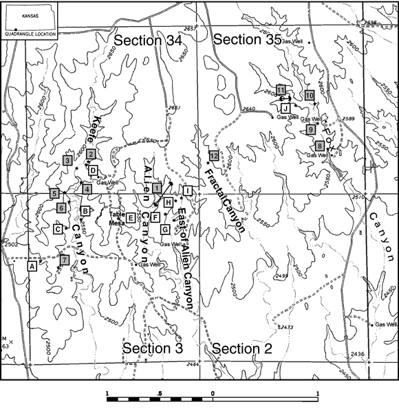
Figure 1. Topographic map showing locations of measured sections (numbers) and fossil sites (letters) along the north bank of the Cimarron River, Meade County, Kansas. Keefe and Fox Canyons are official names shown on the Kismet SE 7.5 min. quadrangle, Kansas-Oklahoma, whereas Alien, East of Alien (EOA) and Fractal Canyons are informal names we have applied to unnamed canyons in the same region. Position of Keefe Canyon on this map differs from that on the Kismet SE quadrangle; see text. Numbers 1-12 are measured sections shown in figures 2 and 3 and described in Appendix I. The positions of fossil localities not in measured sections are identified as follows: A= Raptor 4, 5; B= Raptor 3A-B; C= Raptor 4; D= Keefe Canyon Quarry (KC) of Hibbard and Riggs (1949); E= Wiens; F= Bishop; G= Ripley A, B; H= Vasquez; I= Newt; J= Fox Canyon locality (FC) of Hibbard (1950). Remaining fossil localities are located within measured sections as follows: 3= KC Turtle; 6= Raptor 1A-C; 8= Red Fox; 10= Taylor mollusk locality 4b. Bar scale in kilometers. Elevation is in feet / Mapa topográfico mostrando la localización de las secciones medidas (números) y sitios fosilíferos (letras) sobre la margen norte del río Cimarrón, condado de Meade, Kansas. Los cañones de Keefe y Fox son nombres oficiales que figuran en el mapa Kismet SE 7,5 min., Kansas-Oklahoma, mientras que los cañones Alien, este de Alien (EOA) y Fractal son nombres informales que hemos aplicado a cañones innominados de la misma región. La posición del cañón de Keefe en este mapa difiere de la del mapa Kismet SE; véase texto. Los números 1-12 son secciones medidas mostradas en las figuras 2 y 3 y descriptas en el apéndice I. La posición de las localidades fosilíferas no situadas en secciones medidas se identifica así: A= Raptor 4, 5; B= Raptor 3A-B; C= Raptor 4; D= Keefe Canyon Quarry (KC) of Hibbard and Riggs (1949); E= Wiens; F= Bishop; G= Ripley A, B; H= Vasquez; I= Newt; J= Fox Canyon locality (FC) of Hibbard (1950). El resto de las localidades fosilíferas se localizan en las secciones medidas como sigue: 3= KC Turtle; 6= Raptor 1A-C; 8= Red Fox; 10= Taylor mollusk locality 4b. Escala en kilómetros, altitud en pies.
Prior to our work, sites reported from the north bank of the Cimarron River included only KU Loc. 22 in Keefe Canyon and UMMP K1-47 in Fox Canyon. The mammalian assemblages from these sites are referred to as the Keefe Canyon and Fox Canyon local faunas (Hibbard and Riggs, 1949; Hibbard, 1950). Although the stratigraphy near the quarries was described in these reports, correlations between the localities were only briefly discussed, usually by reference to stratigraphic position relative to a formal rock unit (Meade Gravels), or a presumed widespread caliche. Stratigraphic and paleontologic work carried out in this area has led to the discovery of many new fossil localities and indicates a more complex stratigraphy than that presented in these older reports.
Below, we first provide a stratigraphic overview of the rocks exposed along the north bank of the Cimarron River and introduce the fossil localities and lists of rodents recovered from them. We also briefly discuss some interpretive problems with specific localities. This is followed by a detailed discussion of the basis for correlations of the fossil localities, utilizing both stratigraphic and faunal information. Detailed stratigraphic descriptions are provided in Appendix I, and preliminary mammalian faunal lists for fossil localities are given in Table 1. We conclude with a synthesis of the geological and faunal correlations leading to a biostratigraphic framework for early Blancan local faunas of the region.
In this paper we do not use the formal name Rexroad Formation for the rocks along the Cimarron River. Our stratigraphic work in progress is revealing what we think are problems involving the inferred stratigraphic position, and consequent correlation of, some rocks outside the type area to rocks within the type area of the Rexroad Formation. These problems directly involve rocks along the north bank of the Cimarron River, which were referred by Hibbard (Hibbard and Riggs, 1949; Hibbard, 1950) to the Rexroad and Meade (=Ballard) Formations. Until we have resolved the lithostratigraphic position of the type Rexroad Formation to the rocks along the Cimarron River, we refrain from applying a formal nomenclature to the rock units between Keefe and Fox Canyons.
Stratigraphic overview and fossil assemblages
Canyons and sections
The Meade Basin is a narrow depression 48 km long, trending in a southwest to northeast direction, extending from the Oklahoma panhandle into southwestern Kansas. The study area for this report is located in southern Meade County along the north bank of the Cimarron River in sections 34 and 35, T. 34 S, R. 30 W and sections 2 and 3, T. 35 S, R. 30 W, in the Kismet SE 7 1/2 minute quadrangle (figure 1). This area includes a series of canyons, which from west to east include Keefe, Alien, East of Alien (EOA), Fractal, and Fox. Keefe and Fox Canyons appear on the USGS Kismet SE quadrangle, whereas the others are informal names we have applied to unnamed canyons. Detailed descriptions of measured sections can be found in Appendix I, and measured section locations are shown in figure 1.
Our measured sections comprise a total thickness of 34 m of Pliocene sediments north of the Cimarron River. These sediments consist of light- to pinkishgray, fine-grained sandstones and siltstones, light yellowish-gray sands and gravels, and scattered gray to white calcium carbonate layers. The fine-grained sandstones and siltstones commonly contain calcareous stringers and nodules that locally form indurated ledges. Some siltstones and fine sandstones are massive, and may in part be eolian; other silty sands, however, contain scattered medium- to coarsegrained lenses, rip-up clasts, and traces of cross-bedding or ripple lamination that together indicate a fluvial origin. Coarse-grained sand and gravel units are fluvial in origin. They vary from unconsolidated to indurated (due to calcium carbonate cementation), even within the same unit. Indurated sands and gravels may form strongly cross-bedded ledges that are traceable for several kilometers. Massive calcium carbonate layers with abundant root traces are interpreted to be pedogenic calcareous accumulations; some show evidence of having formed from the amalgamation of carbonate nodules and stringers. Other massive calcium carbonate layers locally contain charophytes and mollusks, and are thought to represent ponds. North of the Cimarron River, several calcium carbonate layers are identifiable and traceable through several canyons.
Locally along the Cimarron River the base of the Pliocene section is exposed and overlies rocks referred to the Laverne Formation (Frye and Hibbard, 1941; Byrne and McLaughlin, 1948). A major sand and gravel unit in the upper part of the Pliocene section has been called the Meade Gravels Member (Hibbard, 1949). Later, the name Angell Member (of the Ballard Formation) was introduced as a substitute for the Meade Gravels Member (Hibbard, 1958). Our preliminary stratigraphic work indicates that both the names Meade Gravels Member and Angell Member have been applied to more than one gravel unit, and therefore in this report we introduce Wolf gravels as an informal name for the gravels formerly called Meade in Fox and Keefe Canyons. The name Wolf gravels is taken from Wolf Canyon in southwestern Meade County, where these gravels are well exposed. In the canyons north of the Cimarron River, the Wolf sands and gravels, which can be traced between the canyons, vary from completely unconsolidated to lithified and strongly cross-bedded.
Fossil localities and vertebrate assemblages
Fossiliferous localities have been found in Keefe, Alien, EOA, and Fox Canyons. Preliminary lists of the rodents are provided in table 1; only those taxa that aid in correlation are included. Detailed studies are currently in preparation, and it is to be expected that some of the nomenclature will change as a result. Localities discussed in the text are listed below, with the following abbreviations: S = small mammals; L = large mammals; MSU = Murray State University locality number.
Keefe Canyon:
Raptor 1A-C (MSU-10-98; three superposed levels; S, L).
Raptor 2 (MSU-11-98; L).
Raptor 3A-B (MSU-12-98; two superposed levels; S, L).
Raptor 4, 5 (MSU-15-98; two localities that probably represent the same sampling level, on either side of a ridge; S).
KC Turtle (MSU-2-99; S).
KC (KU Loc. 22; Hibbard and Riggs [1949] original quarry locality; S, L).
KCN (MSU-2-98; ca. 5.0 m north of KC; L).
Alien Canyon:
Wiens A-D (MSU 1-98; four superposed levels; S, L).
East of Alien Canyon:
Bishop (MSU-4-99; L).
Ripley A-B (MSU-7-99; two superposed levels; S, L).
Camel Pod (MSU-5-99; L).
Vasquez/Newt (MSU-19-99/MSU-6-99; two localities ca. 10.0 m apart; probably once connected; S, L).
Fox Canyon
Fox Canyon (UM-K1-47 = Rexroad Loc. 6; Hibbard [1950] original locality; S, L).
Red Fox (MSU-16-00; S).
Taylor 4b (one of D. W. Taylor [1960, 1966] mollusk localities).
Keefe Canyon, as used in Hibbard and Riggs (1949) and in this paper, runs north-south and extends through the SW1/4, sec. 34, T. 34 S., R. 30 W. and the NW1/4 sec. 3, T. 35 S., R. 30 W., Meade County, Kansas. Local residents have pointed out to us the remains of the dugout in which the original Mr. Keefe resided, located south of the original Keefe Canyon quarry (KU Loc. 22; Hibbard and Riggs, 1949), near the mouth of the canyon. We mention this detail because the canyon labeled as Keefe Canyon on the USGS Kismet SE 7 1/2 minute quadrangle is actually the canyon to the west of that which contains Hibbard and Riggs' quarry (KC) and the dugout. Also, the footages relative to section corners given by Taylor (1966) for the location of the KC quarry are incorrect, and place the quarry in the canyon labeled as Keefe on the 7 1/2 minute map. Mr. Spencer Wiens of Meade first took us to the KC quarry, which was immediately recognizable by comparisons with photographs in Hibbard and Riggs (1949). Some of our new fossil sites and measured sections and Hibbard and Riggs' Keefe Canyon fossil quarry are located in the canyon with the dugout (figure 2).
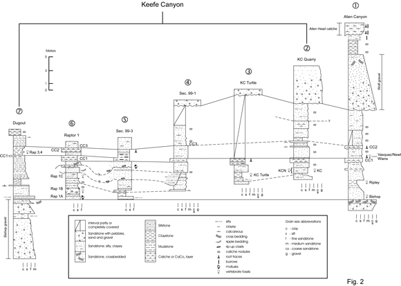
Figure 2. Measured sections in Keefe Canyon and their correlation with the section in Alien Canyon. Position of fossil localities in EOA Canyon (Bishop, Ripley, Vasquez/Newt) projected into Alien Canyon section. CC = Calcium carbonate marker units / Secciones medidas en cañón Keefe y las correlaciones propuestas con la sección en el cañón Alien. La posición estratigráfica relativa de las localidades fósiles en el cañón EOA (Bishop, Ripley, Vasquez/Newt) se han representado en la sección del cañón Alien. CC = Unidades marcadoras de carbonato de calcio.
In their 1949 paper, Hibbard and Riggs concluded that the fossil deposit at KU Loc. 22 represented an old artesian spring basin. The fossils were recovered from a lenticular flour sand horizon (maximum thickness of 1 meter) fed by a vertical sand-filled tube. The deposit may have been completely mined out by Hibbard and associates, since we found no evidence of the sand-filled tube or the flour sand horizon at the quarry. Instead, we found bone fragments in a 1.45 m interval within fine-grained silty sandstones (figure 2, section 2, KCN) in the walls of the wash 5.0 m north of KC, at what we believe to be the stratigraphic position of KC. Washing of test samples from this 1.45 m interval yielded no identifiable specimens, but two Equus molars were recovered in situ in summer 2002.
Among several new localities found in Keefe Canyon is one, Raptor 3, that has an unusual lithology. Bones of large mammals and rodent teeth are found in an area where the basal calcium carbonate layer is fractured and has collapsed, with selenite crystals and plates filling the fractures. The bones are partly covered with selenite. This locality probably represents an old spring, with mineralized waters likely derived from the solution of underlying Paleozoic evaporites. A well (Stanolind Oil and Gas Company, A.W. Adams No. 1) drilled 4.57 km southwest of Raptor 3 in the SW corner of SW 1/4 sec. 8, T. 35 S., R. 30 W., intersected gypsiferous and anhydrite-bearing rocks of the Paleozoic Nippewalla and Sumner Groups. For example, a 22 m thick gypsum bed is present in the Flowerpot Shale in this well (Lee, 1953). Raptor 3 is subdivided into two superposed levels, a lower A unit and an upper B unit. Raptor 3A produced the microfauna reported in Table 1.
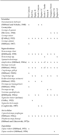
Table 1. Rodent species recovered from fossil localities along the north bank of the Cimarron River, Meade County, Kansas / Especies de roedores encontrados en las localidades fosilíferas a lo largo de la ribera norte del río Cimarrón, condado de Meade, Kansas.
In Fox Canyon (figure 3), we located a sandy horizon that appears to be the source of Hibbard's (1950) Fox Canyon l.f. Large and small mammal bones are commonly found in a two meter thick sand, the top of which is 6.5 m topographically below a massive caliche (our CC1 in figure 3) that caps the exposure. We sampled the unit at this level and recovered Pliophenacomys finneyi , an extinct arvicoline rodent that characterizes the Fox Canyon local fauna. However, Hibbard (1950) noted that most of his specimens were recovered from a pocket of sandy silts that grade laterally into channel sands 5.18 m below CC1 (Hibbard's locality UM-K1-47). The top of the sandy horizon to the north across the wash from UM-K1-47 is 5.30 m below CC1; the difference between Hibbard's and our measurements at the original quarry is due to a massive slumping of sediments at the quarry since Hibbard's measurements were taken. Our measured section in figure 3 (Fox Canyon W.) is a composite, with the lower part (CC1 and below) taken roughly 50 m west of the fossil quarry, and the upper portion (above CC1) measured directly above the fossil quarry.
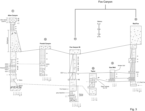
Figure 3. Measured sections and correlations in Fox, Fractal, and Alien Canyons / Secciones medidas y correlaciones propuestas entre los cañones Fox, Fractal y Alien.
Correlations
In the following section we describe stratigraphic correlations based on tracing various marker units, such as calcium carbonate layers and gravels. Faunal evidence is provided for support where appropriate, but is never the primary source of correlation. Twelve stratigraphic sections were measured between Keefe and Fox Canyons using a Jacob's staff and tape; corrections for dip of the rocks were applied where warranted. The stratigraphic sequence in this area is characterized by a lower, thick sand and gravel unit locally at least 9.0 m thick that is usually consolidated and cross-bedded near its top. We call this unit informally the Bishop gravel, named after a large mammal locality associated with this horizon in EOA Canyon. A second sand and gravel unit, the Wolf gravel, is located approximately 13.5-17.0 m above the Bishop gravel. It is mostly unconsolidated, with some consolidated and cross-bedded ledges at various levels. Between these two gravels we recognize three calcium carbonate layers: (1) a lower massive white layer (unit CC1), with charophytes and ostracods visible in its upper half in some hand samples, (2) a middle, grayish, pitted layer, which contains root traces but no charophytes (unit CC2), and (3) an upper layer that where well exposed may be expressed as wavy carbonate stringers of varying thickness, associated with mudstones in the development of vertisol structure, or as isolated carbonate nodules in poor exposures (unit CC3). These units may vary locally in thickness and in appearance. Finally, a 2.0 m thick calcium carbonate layer, informally called the Alien Head caliche, is present 3.0 m above the Wolf gravel. The name derives from the similarity of the caliche caprock at the head of Alien Canyon to the head of the monster by the same name in the movie Alien (fossil quarries and some gullies in EOA Canyon are named after characters in the Alien movie series [Martin et al ., 2000]). Below, we describe stratigraphic correlations in the five major canyons in our study area, moving from west to east, beginning with Keefe and ending with Fox Canyon.
We measured six sections in Keefe Canyon (figure 2). The Bishop gravel crops out in the southern most measured section (Dugout section; section 7), where the canyon is most deeply cut. Higher in section 7 is CC1, which is traceable up canyon as a prominent white ledge through the six measured sections. It is our primary correlational unit in Keefe Canyon. When sediments are well exposed immediately above CC1, large mammal fossils are usually present. Three fossil localities in Keefe Canyon represent this horizon (Raptor 3-5). CC1 is the same unit as the massive caliche 2.0 m above KU Loc. 22 (KC) described by Hibbard and Riggs (1949). In Keefe Canyon there are three fossil localities at this distance below CC1; KC (figure 2, section 2), KC Turtle (figure 2, section 3), and Raptor 1C (figure 2, section 6). A mollusk zone at least 0.3 m thick, Raptor 1A, is present in silty sands 2.4 m below the Raptor 1C level, the same distance as Hibbard and Riggs (1949, p. 833) reported for a mollusk zone below KC. This stratigraphic correlation is further supported by the record of Sigmodon holocuspis , a primitive sigmodontine rodent, from both Raptor 1C and KC. Good exposures of sediments between the Bishop gravel and CC1 show lateral facies changes interpreted as cross-cutting channels and their associated overbank deposits. Near KC (figure 2, section 2), 8.3 to 8.8 m of sandstone, siltstones, and calcium carbonate layers separate CC1 from the overlying Wolf gravel. CC2 and CC3 are found in this interval. Unit CC3 is well-exposed at the top of measured sections 4-6 (figure 2) as a distinctive, pale orange-brown siltstone and silty sandstone containing thin, undulating layers of calcium carbonate nodules and stringers interpreted as a vertisol.
Correlations of units between the localities in Keefe Canyon and those in the canyons to the east are established by following units CC1, CC2, and CC3 across the divide on the south side of Table Mesa, in NE1/4, SE1/4, NW1/4 sec. 3, T. 35 S., R. 30 W. Correlations have also been established by following the Wolf gravel unit north of Table Mesa. As in Keefe Canyon, we found both scattered large mammal bone and quarryable concentrations of bone (the rich Wiens locality) in Alien Canyon in sediments directly above CC1. East of the Wiens locality, CC1 and CC2 are visible as a couplet that can be traced across the hill-slopes, through Alien Canyon, and into the succession of localities in EOA Canyon. Measured section 1 (figure 2) is from Alien Canyon, and also includes the measured levels of the new fossil localities in EOA Canyon. The section in Alien Canyon is the most complete that we have found north of the Cimarron River. Due to a 2° to 3° dip of Pliocene sediments toward the river in Alien and EOA Canyons, erosion does not penetrate into the lower portions of the sediments, even in the lower reaches of the canyons. The lowest fossil level is Bishop, a large mammal site in mudstones immediately on top of the Bishop gravel. Lateral to the Bishop fossil site the underlying sand and gravel is cross-bedded, but immediately beneath the site the sandstone is convoluted. This disturbed bedding may have been the result of bioturbation by animals, or due to water escape at the site of an ancient spring. Support for the latter idea is found at the Camel Pod locality in this canyon about 100 m east of Bishop. Here, lenticular masses of highly calcareous sandstone, some with mammal bones, are connected by three dikes to the sand and gravel unit underlying Bishop. We believe that these dikes represent the conduits to a spring, and that the sand filling these dikes was injected from the underlying sand and gravel unit.
Ripley A, located 2.2 m above the Bishop gravel, is a light greenish-gray, fine-grained silty sandstone containing mollusks. Ripley B, a dark grayish-brown, organic-rich sandstone and siltstone, containing abundant large mammal bones and rodent teeth, is developed directly above Ripley A. Both units likely represent a pond deposit. The top of the Ripley A level is 2.8 m below CC1 (figure 3; measured section 1), compared to a distance of 1.8 m below CC1 for Raptor 1C in Keefe Canyon. The inferred stratigraphic position of Ripley B below Raptor 1C is indirectly substantiated by comparison of cotton rat specimens from Raptor 1C, Ripley B, and the House Mountain locality of the Verde l.f, the type locality of Sigmodon holocuspis . Both S. holocuspis and S . Minor were recorded by Czaplewski (1987) from House Mountain. The cotton rat from Ripley B represents a more primitive morphological grade of S. minor than that from House Mountain (Peláez-Campomanes and Martin, in preparation), whereas Raptor 1C has only S . holocuspis , and is therefore tentatively correlated with House Mountain.
Two rich micromammal localities, Vasquez and Newt, lie between CC1 and CC2 near the head of EOA Canyon. The eastern edge of deposits that produced the Vasquez l.f. is separated by a small gully from the western edge of the locality producing the Newt l.f. It is highly probable that the two were once connected, and therefore represent the same sampling interval. These localities are at the same general stratigraphic level as Wiens (in Alien Canyon) and Raptor 3-5 (in Keefe Canyon).
In Alien Canyon 5.4 m of grayish-orange siltstones and fine-grained silty sandstones containing local concentrations of carbonate nodules and stringers are located between CC2 and the Wolf gravel; this interval is partly equivalent to unit CC3 in Keefe Canyon. The section is capped by a 1.8 m cliff-forming caliche containing abundant root traces and probable burrows that forms the upland surface just north of the river.
Tracing of beds between Fox Canyon and EOA Canyon is hampered by extensive cover and the presence of a collapse basin in section 2, T. 35 S., R. 30 W. This collapse explains the southward dip of Pliocene sediments toward the Cimarron River in Fox Canyon and in the EOA Canyon area. Fortunately, an outcrop in a small canyon (Fractal Canyon; figure 3, section 12) situated between Fox and EOA Canyons, in the SW1/4 sec. 35, T. 34 S., R. 30 W, appears to provide the necessary connection. A prominent 0.55-1.2 m thick ledge of interbedded wavy carbonate and silty sandstone is found there, the top of which is 5.3 m below the Wolf gravel. The former unit is lithologically similar to unit CC3 in Keefe Canyon, and the base of both units (figures 2, 3; measured sections 12 and 4) are nearly the same distance below the Wolf gravel, differing only by about 0.5 m. Therefore, we tentatively conclude that the units are equivalent.
The Fox Canyon locality of Hibbard (1950) is 1.56 km northeast of the EOA localities. Four sections were measured in Fox Canyon (figure 3, sections 8-11). Section 11 was measured about 50 m upstream from Hibbard's Fox Canyon locality (UM-K1-47). About 7.0 m below the base of the Wolf gravel at measured section 11 and 10.5 m below the Wolf gravel at section 8 is a prominent caliche that forms a white band across the hillsides in this area. Locally it forms a massive bench showing root traces. Hibbard (1950: p. 120) reported this caliche to be 6.7 m below the Meade Gravels at the Fox Canyon quarry, and believed that this massive caliche zone was the same as the caliche 2.0 m above UK loc. 22 (unit CC1 in figure 2). He compared the stratigraphic distances of his Fox Canyon and KC sites below these (assumed equivalent) caliches, and concluded that the Fox Canyon site was slightly lower stratigraphically than the KC quarry. Our correlations generally support this interpretation.
The Red Fox mammal locality (figure 3, section 8) is 3.0 m below CC1, and correlates stratigraphically to D. W. Taylor's mollusk locality 4b (Taylor, 1960; = Rexroad loc. 15 of Taylor, 1966) (figure 3, section 10). Using CC1 as a marker unit, these localities are stratigraphically higher than Hibbard's Fox Canyon locality, and may represent the same stratigraphic level that produced the Ripley l.f. in EOA Canyon (figure 3, section 1). Although the collection of rodent molars from Red Fox is small, the absence of Pliophenacomys finneyi , a common rodent from Hibbard's Fox Canyon locality, further suggests a chronological difference from Hibbard's site.
Synthesis and conclusions
A stratigraphically controlled succession of vertebrate faunas, presented as a composite section with regional geologic markers, is presented in figure 4. Within that framework, some further partitioning is possible based on preliminary evidence from the rodents and the new arvicoline rodent zonation for the central Great Plains provided by Martin (2003). For instance, Fox Canyon time is characterized by two geomyids ( Geomys minor [= G. smithi Hibbard, 1967] and the diminutive G. adamsi ), two arvicolids ( Pliophenacomys finneyi and Ogmodontomys poaphagus ), and the absence of cotton rats. Geomys adamsi is not encountered in the Meade Basin after Fox Canyon. It is a primitive species that has been tentatively identified only at the early Blancan Pipe Creek l.f. from Indiana (Martin et al ., 2002a). Likewise, P. finneyi is restricted to Fox Canyon. A large but morphologically primitive cotton rat, Sigmodon holocuspis , at KC and Raptor 1C is followed by a small, dentally archaic form of S . minor at Ripley B. Cotton rats are absent from the Wiens, Vasquez/Newt and Raptor 3-5 l.fs. We tentatively interpret the oscillations in cotton rat populations as evidence of climatic change, with times of absence implying colder winters (Martin, 1986; Martin and Fairbanks, 1999).
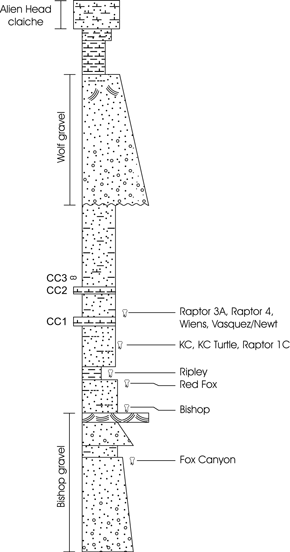
Figure 4. Composite measured section showing stratigraphic positions of fossil localities along the north bank of the Cimarron River, Meade County, Kansas / Sección estratigráfica compuesta mostrando la posición de las localidades fosilíferas a lo largo de la ribera norte del río Cimarrón, condado de Meade, Kansas.
Local faunas recovered beneath the Bishop gravel south of the Cimarron River in Seward County, such as Hibbard's original Saw Rock Canyon (SRC) l.f. (Hibbard 1953; 1964) and our SRC 1, Argonaut, and Fallen Angel B l.fs. (Martin et al ., 2000), contain the archaic arvicolid Ogmodontomys sawrockensis Hibbard (1957). A very primitive cotton rat, identified only as Sigmodon sp., is present at Argonaut and Fallen Angel, but is absent from the lower part of the section with SRC and SRC 1. Once again, this probably indicates a climatic shift to either cooler or drier conditions or a combination of both.
Our field work over the past few years indicates that the stratigraphy of the Meade Basin is more complex than the hypotheses presented in older works ( e.g ., Hibbard, 1958; Zakrzewski, 1975; Bayne, 1976). The identity of some sediments referred to the Ballard Formation has been questioned (Martin et al ., 2002b), and we do not currently recognize this formation except at the type locality on the Big Springs Ranch, which is not accessible to scientists. It is also problematic to extend use of the Rexroad Formation south from its type locality near Meade State Park to the north bank of the Cimarron River, and until some thorny problems are resolved in the type area, we refrain from doing so. There are a number of Blancan gravel units in Meade County, at different stratigraphic levels, that have been miscorrelated in the past; we therefore choose to introduce the informal Wolf and Bishop gravels for those in southern Meade County simply to avoid confusion. Fortunately, in the Cimarron River area the Bishop and Wolf gravels and a series of caliche units (CC1, CC2, CC3) can be followed through the canyons and used effectively as stratigraphic markers.
Acknowledgments
It is our pleasure to acknowledge J. and P. Adams and W. Fox, Jr., who own the land on which we worked. Their families have assisted in paleontological research in Meade County for almost 70 years, and we are extremely grateful for their enthusiastic cooperation. D. Porter and R. Zakrzewski contributed their expertise in the field, and we also thank the many university students who have been associated with the project. G. Gunnell, P. Gingerich and L. Martin allowed study of critical museum specimens. Their hospitality is much appreciated. This research was supported by National Geographic Society grants 5963-97 and 6547-99 and National Science Foundation grant EAR-0207582, with matching funds from MSU.
References
Bayne, C.K. 1976. Early and medial Pleistocene faunas of Meade county, Kansas. In: C.K. Bayne (ed.), Guidebook 24º annual meeting Midwestern friends of the Pleistocene. Kansas Geological Survey, Lawrence, Guidebook Series 1, pp. 1-25. [ Links ]
Byrne, F.E. and McLaughlin, T.G. 1948. Geology and ground-water resources of Seward County, Kansas. State Geological Survey of Kansas, Bulletin 69: 1-140. [ Links ]
Czaplewski, N.J. 1987. Sigmodont rodents (Mammalia; Muroidea; Sigmodontinae) from the Pliocene (early Blancan) Verde Formation, Arizona. Journal of Vertebrate Paleontology 7: 183-199. [ Links ]
Frye, J.C. and Hibbard, C.W. 1941. Pliocene and Pleistocene stratigraphy and paleontology of the Meade Basin, southwestern Kansas. State Geological Survey of Kansas, Bulletin 38: 389-424. [ Links ]
Gidley, J.W. 1922. Preliminary report on fossil vertebrates of the San Pedro Valley, Arizona, with descriptions of new species of Rodentia and Lagomorpha. U. S. Geological Survey Professional Paper 131: 119-131. [ Links ]
Hibbard, C.W. 1938. An Upper Pliocene fauna from Meade County, Kansas. Transactions Kansas Academy of Sciences 40: 239-265. [ Links ]
Hibbard, C.W. 1941a. New mammals from the Rexroad fauna, Upper Pliocene of Kansas. American Midland Naturalist 26: 337-368. [ Links ]
Hibbard, C.W. 1941b. Mammals of the Rexroad fauna from the Upper Pliocene of southwestern Kansas. Transactions Kansas Academy of Sciences 44: 265-313. [ Links ]
Hibbard, C.W. 1949. Pleistocene stratigraphy and paleontology of Meade County, Kansas. Contributions from the Museum of Paleontology, University of Michigan 7: 63-90. [ Links ]
Hibbard, C.W. 1950. Mammals of the Rexroad Formation from Fox Canyon, Meade County, Kansas. Contributions from the Museum of Paleontology, University of Michigan 8: 113-192. [ Links ]
Hibbard, C.W. 1951. A new jumping mouse from the Upper Pliocene of Kansas. Journal of Mammalogy 32: 351-352. [ Links ]
Hibbard, C.A. 1952. A contribution to the Rexroad fauna. Transactions Kansas Academy of Sciences 55: 196-208. [ Links ]
Hibbard, C.W. 1953. The Saw Rock Canyon fauna and its stratigraphic significance. Papers Michigan Academy Science, Arts, and Letters 38: 387-411. [ Links ]
Hibbard, C.W. 1954. Second contribution of the Rexroad fauna. Transactions Kansas Academy of Sciences 57: 221-237. [ Links ]
Hibbard, C.W. 1956. Vertebrate fossils from the Meade Formation of southwestern Kansas. Papers Michigan Academy Science, Arts and Letters 41: 145-203. [ Links ]
Hibbard, C.W. 1957. Two new Cenozoic microtine rodents. Journal of Mammalogy 38: 39-44. [ Links ]
Hibbard, C.W. 1958. New stratigraphic names for early Pleistocene deposits in southwestern Kansas. American Journal of Science 256: 54-59. [ Links ]
Hibbard, C.W. 1964. A contribution to the Saw Rock Canyon local fauna of Kansas. Papers Michigan Academy of Science, Arts, and Letters 49: 115-127. [ Links ]
Hibbard, C.W. 1967. New rodents from the late Cenozoic of Kansas. Papers Michigan Academy of Science, Arts, and Letters 52: 115-131. [ Links ]
Hibbard, C.W. and Riggs, E.S. 1949. Upper Pliocene vertebrates from Keefe Canyon, Meade County, Kansas. Bulletin of the Geological Society of America 60: 829-860. [ Links ]
Hibbard, C.W. and Schultz, C.B. 1948. A new sciurid of Blancan age from Kansas and Nebraska. Bulletin Nebraska State Museum 3: 19-29. [ Links ]
Hibbard, C.W. and Zakrzewski, R.J. 1972. A new species of microtine from the late Pliocene of Kansas. Journal of Mammalogy 53: 834-839. [ Links ]
Lee, W. 1953. Subsurface geologic cross section from Meade County to Smith County, Kansas. State Geological Survey of Kansas, Oil and Gas Investigations 9: 1-23. [ Links ]
Martin, R.A. 1986. Energy, ecology, and cotton rat evolution. Paleobiology 12: 370-382. [ Links ]
Martin, R.A. 2003. Biochronology of latest Miocene through Pleistocene arvicolid rodents from the central Great Plains of North America. Coloquios de Paleontologia, Volumen extraordinario 1: 373-383. [ Links ]
Martin, R.A. and Fairbanks, K.B. 1999. Cohesion and survivorship of a rodent community during the past 4 million years in southwestern Kansas. Evolutionary Ecology Research 1: 21-48. [ Links ]
Martin, R.A., Honey, J.G. and Peláez-Campomanes, P. 2000. The Meade Basin rodent project: a progress report. Paludicola 3: 1-32. [ Links ]
Martin, RA., Goodwin, H.T. and Farlow, J.O. 2002a. Late Neogene (late Hemphillian) rodents from the Pipe Creek Sinkhole, Grant County, Illinois. Journal of Vertebrate Paleontology 22: 137-151. [ Links ]
Martin, R.A., Honey, J.G., Peláez-Campomanes, P., Goodwin, H.T., Baskin, J.A. and Zakrzewski, R.J. 2002b. Blancan lagomorphs and rodents of the Deer Park assemblages, Meade County, Kansas. Journal of Paleontology 76: 1072-1090. [ Links ]
McGrew, P.O. 1944. An early Pleistocene (Blancan) fauna from Nebraska. Geological Series Field Museum of Natural History 9: 33-66. [ Links ]
Smith, G.R. and Friedland, N.E. 1975. Studies on Cenozoic paleontology and stratigraphy in honor of Claude W. Hibbard. University of Michigan Papers on Paleontology 12: 1-143. [ Links ]
Taylor, D.W. 1960. Late Cenozoic molluscan faunas from the High Plains. U.S. Geological Survey Professional Paper 337: 1-94. [ Links ]
Taylor, D.W. 1966. Summary of North American Blancan nonmarine mollusks. Malacologia 4: 1-172. [ Links ]
Zakrzewski, R.J. 1975. Pleistocene stratigraphy and paleontology in western Kansas: the state of the art, 1974. In: G.R. Smith and N.E. Friedland (eds.), Studies on Cenozoic Paleontology and Stratigraphy in Honor of Claude W. Hibbard. The University of Michigan, Museum of Paleontology. Papers on Paleontology 12: 121-128. [ Links ]
Recibido: 26 de diciembre de 2003.
Aceptado: 20 de octubre de 2004.
Appendix I
Measured Sections (thickness in meters)
Measured Section 1: measured by J. Honey and P. Peláez-Campomanes, 1998
Top of section
14. Indurated caprock: CaCO3 horizon in orange-brown, silty, finegrained sandstone; rooted; burrowed; brecciated upper part; CaCO3 becomes more massive upwards 1.30
13. CaCO3, massive, indurated; shows mudcracks and slickensides; burrowed; base of CaCO3 horizon convoluted, and thickness of unit variable 0.61
12. Interbedded light brownish gray, clayey, very fine grained sandstone and sandy claystone; calcareous; burrows and possible roots present; forms cliff. Unit variable in thickness 0.91
11. Claystone, light brownish gray, slightly sandy, interbedded with thin (= 3 cm) layers of diffuse and nodular CaCO3; claystone layers up to 0.23 m thick. Upper 0.46 m of unit with less CaCO3 2.07
10. Sandstone, very fine to fine-grained, slightly silty, lacks pebbles; friable; grades below into underlying unit as part of fining-upwards package 1.13
9. Sand and gravel, yellowish-gray, crossbedded, with pebbles up to 7 cm long; unconsolidated. Pebbles decrease in size and sorting improves upwards. Blocks of cemented, crossbedded sand and gravel locally present. Rare bone fragments present 7.28
8. Sandstone, pinkish- to orange-gray, very fine grained, clayey. Lower half of unit with numerous CaCO3 nodules that form a prominent white, rubble slope; upper half of unit without nodules. Clay content increases in upper 0.61 m. Sharp top contact 3.14
7. Partly covered interval: sandstone, pinkish-gray, very fine grained, silty, massive; less silty in upper part; scattered CaCO3 nodules form rubble slope 2.23
6. CaCO3; light gray; contains root traces; forms ledge or rubble slope; up to 1.00 m thick laterally 0.40
5. Interbedded light greenish gray, very fine grained silty sandstone and sandy siltstone in lower half of unit, dominantly pinkish-gray silty sandstone in upper half of unit. Vertical root traces locally present. CaCO3 nodules up to 0.15 m across found about 0.8 m up from base. Sharp top contact. Bones are found nearby at this level, and locality MSU-1-98 (Wiens) is in this unit 1.60
4. CaCO3, white, locally with charophytes; forms prominent ledge. Wavy base 0.61
3. Sandstone, containing two cycles of reddish-brown, silty sandstone fining upwards from fine- to very fine grained. A thin layer of CaCO3 nodules is present 0.8 m up in unit and separates the two cycles. Lowest 0.8 m of unit locally shows low-angle crossbedding. Sharp top contact 1.91
2. Sandstone, orange-gray, friable, grading upwards into light-gray silty claystone 3.73
1. Sandstone, light orange brown, medium- to coarse-grained and containing some pebbles and cobbles; mostly unconsolidated except for some cemented, crossbedded ledges in upper part of unit; top 0.46 m of unit cemented and containing pebbles up to 2 cm long 1.68+
Base of exposure
Total measured section 28.60
Measured Section 2: measured between 6 and 18 m north of location of UK fossil locality 22, by J. Honey and P. Peláez-Campomanes, 1998.
Top of section
14. Unconsolidated gravelly sandstone; same as units 9 and 10 of measured section 1 5.79
13. Silty sandstone, light grayish brown; chippy weathering; contains CaCO3 mottling and scattered CaCO3 nodules. Sharp upper contact 2.53
12. CaCO3 zone, with nodules in reddish-brown, silty, very fine grained sandstone matrix; forms white layer on slope 1.34
11. Sandstone, greenish-gray, very fine grained, silty, massive, with CaCO3mottling 1.40
10. Claystone, reddish-brown, sandy 0.40
9. CaCO3 ledge, white 0.08
8. Light brownish gray, very fine grained silty sandstone and sandy siltstone; slightly blocky weathering; contains CaCO3 mottling and scattered nodules; massive. Forms gentle slope 0.76
7. CaCO3 layer, white, massive; irregular thickness 0.10
6. Sandstone, orange-brown, very fine to lower fine grained; massive with scattered CaCO3 nodules and stringers 1.68
5. CaCO3 zone, variable thickness, consisting of nodules in a light greenish gray to brownish-gray silty, very fine grained sandstone matrix; contains three CaCO3 horizons, the thickest one at the base of the unit 0.91
4. Silty sandstone, light greenish gray, very fine grained, slightly clayey; massive, with blocky weathering in places; contains scattered CaCO3 nodules; gradational lower contact with unit 3. Lower half of unit 4 included in Keefe Canyon layer C 0.46
3. Silty sandstone, dark brownish gray, very fine grained, slightly clayey and organic. Contains bone (= Keefe Canyon layer C) 0.15
2. Sandstone, light greenish gray, very fine grained with scattered medium grains; massive; hard. Contains bone (= Keefe Canyon layer B). Gradational top and base of unit 0.61
1. Sandstone, brownish-orange, upper fine to lower medium grained with scattered lower coarse grains; silty; massive in lower 0.61 m. Fines upward to very fine or fine-grained, greenish-gray sandstone, and in top 0.10 m is a greenish-gray sandy claystone. Keefe Canyon layer A is from 0.61 m to 0.98 m above base of section 1.07
Base of exposure
Total measured section 17.28
Measured Section 3: measured by J. Honey and D. Porter, 1999.
Top of section
11. Sand and gravel; not measured
10. Covered interval 9.60
9. Indurated CaC03 caprock; abundant root holes and vertical tubes 1-10 mm across; undulating base 0.45
8. Mudstone, light brownish gray, containing very fine grains of sand; carbonaceous; calcareous 0.13
7. Silty mudstone, light medium gray, with scattered very fine grains of sand; extremely calcareous, hard; relict root traces 0.33
6. Sandstone, lower very fine grained, silty. Upper half of unit shows clay content increasing upward. Top 0.23 m contains carbonaceous material and clay films, and shows orange mottling along root traces 1.13
5. Claystone, calcareous, with carbonate nodules up to at least 0.08 m across scattered throughout unit. Bottom 0.17 m contains more carbonate nodules. Upper 0.36 m possibly pedogenically modified 0.52
4. Claystone, with orange mottling. Gradational top contact 0.30
3. Claystone, olive-green, slightly sandy, with scattered brownish-black carbonaceous streaks; massive. Contains some probable burrows. Contains bone in basal 0.08 m of unit. Grades into overlying unit 0.16
2. Claystone, pale brown, silty, slightly sandy; massive. Sharp top contact 0.47
1. Sandstone, light orange gray, very fine grained with scattered coarse grains. Contains burrows filled with fine- to medium-grained sandy clay and soft masses of carbonate. Grades into overlying unit through a contact of one or two cm 0.23+
Start near base of exposure
Total measured section 13.32
Measured Section 4: measured by J. Honey and D. Porter, 1999.
Top of section
7. Sand and gravel; same as units 9 and 10 of measured section 1 4.88 Covered interval 3.02
6. Sandy mudstone, reddish-brown, with disseminated CaCO3 nodules and discontinuous ledges; probable vertisol 3.00
5. Sand, light reddish brown, silty, massive; forms cliff 2.06
4. Interbedded sandy CaCO3 and pale olive gray, silty sand, locally calcareous; fossil root traces present. This unit correlates with lower part of unit 9 of measured section 5 0.53
3. Sandstone, reddish-brown, silty, massive; contains zone of carbonate nodules about 0.15 m thick starting 0.15 m above base of unit. Forms vertical cliff 1.65
2. Siltstone, reddish-brown, sandy; contains vertical cracks; locally truncated by sands that may be related to the overlying cliff-forming sandstone 0.79
1. Sandstone, very fine grained, silty; contains thin, discontinuous CaCO3 interbeds up to 3 cm, and scattered root traces. Top of unit defined by a discontinuous CaCO3 ledge. Beds making up this unit converge from north to south over a distance of 18.3 m; appears to be of fluvial origin ~1.67
Total measured section 17.6
Measured Section 5: measured by J. Honey and D. Porter, 1999.
Top of section
11. Sandstone, pale orange brown, very fine grained, silty, contains scattered CaCO3 layers and nodules up to 0.06 m in length; probable vertisol 1.98
10. Siltstone, light-gray, sandy, with disseminated CaCO3 nodules and scattered minute root traces; weakly ledge-forming at top. Grades into overlying unit 0.41
9. Calcareous mudstone, very light gray, composed mainly of fusing CaCO3 nodules. Lower 0.41 m forms resistant CaCO3 ledge; top 0.79 m shows upwards decrease in nodules 1.19
8. Sandstone, pale orange brown, very fine grained, quartzitic, slightly silty; contains scattered CaCO3 nodules in local lenses; traces of low-angle crossbedding; CaCO3 rip-up clasts in basal 15 cm. Undulating lower contact with up to 0.15 m relief. Thickness measurement taken on edge of channel; in deepest part of channel, unit 10 is 3.05 m thick 0.76
7. Sandstone; orange-brown, very fine grained; traces of cross-laminae; scattered root traces; contains some mollusks 0.51
6. Sandstone, very fine grained, silty at top; concentrations of CaCO3 rip-up clasts at base of unit; massive. Gradational top contact 1.50
5. Sandstone, pale orange brown, very fine grained, silty, faint traces of bedding; discontinuous 0.05 m CaCO3 layer about 0.41 m above base; thin clay stringers and scattered carbonaceous material in upper part of unit. Sharp top contact 1.32
4. Sandstone, very fine grained, silty; contains some clay laminae and disseminated CaCO3. Sharp top contact 0.25
3. CaCO3 layer, white, formed in silty clay; contains minor root traces. 0.03 m thick clay layer present 0.18 m up from base of unit 0.28
2. Silty claystone, light-brown in lower 0.38 m, olive-green in upper 0.27 m; contains scattered fine- to medium-grained sand; some small burrows; upper 0.27 m with some carbonaceous stringers and increasingly calcareous. Gradational top contact 0.65
1. Sandstone, light-brown, very fine grained, silty, clayey 0.30+
Total measured section 9.15
Measured Section 6: measured by J. Honey and P. Peláez-Campomanes, 1998.
Top of section
13. Sandstone, orange-brown, silty; calcareous. Correlates with probable vertisol (unit 11) in measured section 5 0.79
12. CaCO3 zone formed in silty, fine- to medium-grained sandstone; forms prominent white layer on outcrop 0.82
11. Sandstone, light brownish gray, mainly fine-grained, silty 0.49
10. CaCO3 zone, white, massive 0.89
9. Sandstone, orange-brown; fine- to medium-grained with lenses of CaCO3 rip-up clasts in basal 0.13 m; small scale crossbedding present; upper part of unit very fine grained and silty. Unit measured near edge of channel; in deepest part of channel, unit is about 1.83 m thick and shows superposed sets of crossbedding 0.61
8. CaCO3, white, massive. Eroded in center of outcrop by unit 9 0.18
7. Sandstone, light orange brown, very fine grained, silty, with a few green clay layers up to 2.5 cm thick; ripple laminated; massive in top 0.46 m. Locally, unit is coarser-grained at base. Sharp, undulating top contact 0.99
6. Sandstone, light grayish green, very fine grained, silty, massive; top 0.13 m of unit calcareous. Sharp top contact with up to 0.30 m relief. Unit thickens to 1.07 m laterally. Contains mammal fossils (locality MSU-10-98) 0.79
5. Unit consisting of 0.30 m thick basal zone of CaCO3 nodule formation, with nodules up to 3 cm across. Upper 0.46 m of unit consists of light greenish gray, very fine grained, silty sandstone containing only rare CaCO3 nodules; top several cm with scattered coarse grains of sand. Sharp top contact 0.76
4. Unit consisting of 0.18 m thick basal zone of CaCO3 nodule formation in a light olive gray, very fine grained, silty sandstone and sandy siltstone. Upper 0.61 m of unit shows columnar structure with CaCO3 mottling, but without distinct CaCO3 horizons 0.81
3. Sandstone, light orange brown grading up to light olive gray; very fine grained, slightly silty, massive; contains scattered CaCO3 nodules forming discontinuous horizon in basal 0.30 m of unit. Top 0.25 m of unit with scattered CaCO3 nodules and columnar structure. Mammal fossils taken from middle of unit 0.86
2. Sandstone, brownish-gray, very fine grained, silty, carbonaceous, containing rare, scattered mollusks. Grades up to light olive gray sandstone with abundant mollusks and scattered CaCO3 nodules and mottling. Probably is part of Hibbard and Riggs's (1949) gastropod-bearing unit 3 in their Keefe Canyon measured section 0.30
1. Sandstone, light yellowish to light olive gray, very fine to finegrained, silty, with scattered mollusks; 1 cm thick CaCO3 layer at top. Probably part of Hibbard and Riggs's (1949) unit 3 0.30+
Total measured section 8.59
Measured Section 7: measured by J. Honey and P. Peláez-Campomanes, 1998.
Top of section
14. CaCO3 zone, containing nodules and laminae in a clayey matrix; cementation increases upwards. Forms rubble bench 1.07
13. Interbedded clayey, very fine grained sandstone and siltstone, light olive gray to light medium gray; contains 5.1 cm thick CaCO3 cemented zone 0.46 m from top of unit 1.52
12. Interbedded light olive gray sandy claystone and clayey sandstone 1.37
11. Interbedded fine-grained, silty sandstone and sandy siltstone in lower 2/3 of unit, pinkish-brown to light medium gray; grades up to medium-to light brownish gray, sandy siltstone in top 1/3 of unit. Top 0.25 m of unit is a CaCO3 zone consisting of partially fused nodules 3.56
10. Claystone, moderate yellowish brown 0.94
9. CaCO3 layer; forms thin bench 0.10
8. Sandstone, pinkish-brown, fine-grained, silty. About 0.76 m above base is a 5 cm thick CaCO3 mottled zone 1.68
7. Muddy sandstone, pinkish-brown, medium- to coarse-grained, with CaCO3 mottling; contains scattered pebbles; 2.5 cm thick CaCO3 layer at top of unit 0.38
6. Claystone, light olive gray with CaCO3 mottling. Sharp top contact 0.23
5. Sandstone, yellowish-gray, very fine to fine-grained, silty; contains scattered carbonaceous fragments and CaCO3 mottling. Gradational top contact 0.46
4. Sandstone, medium- to coarse-grained with a few thin silty and clayey laminae; crossbedding present, outlined by carbonaceous material. Locally forms cemented ledge 0.13
3. Sandstone, yellowish-orange, medium- to coarse-grained with scattered pebbles and cobbles. Fines up to fine- to lower medium grained with only a few pebbles. Gradational top contact 1.42
2. Sandstone, reddish-brown, fine-grained, clayey and silty; scattered CaCO3 mottling. Sharp top contact 0.76
1. Sandstone, yellowish-gray, medium- to coarse-grained; contains pebbles of white quartz, gray chert, and red granitic rock in lower part of unit. Fines upward to fine- to medium-grained. Top of 20 cm thick, yellow cemented ledge containing scattered pebbles, is present 0.53 m down from top of unit. Top contact gradational; base not exposed 5.89+
Total measured section 19.51
Measured Section 8 (MSU-16-00): measured by J. Honey, P. Peláez-Campomanes, and R. Martin, 2001.
Top of section
14. Sand and gravel, unconsolidated; mostly covered 7.16
13. Sandstone, light-brown, very fine to fine-grained, slightly silty with CaCO3 mottling; strongly CaCO3 cemented in top 0.74 m 1.52
12. Partly covered interval consisting of very fine grained, silty sandstone; contains CaCO3 nodules that decrease in abundance upwards. Sharp top contact 3.99
11. Partly covered interval consisting of light-brown, very fine grained sandy siltstone; contains abundant CaCO3 nodules and rubble that forms white band across hillside. Gradational top contact 1.68
10. Mostly covered interval apparently consisting of pinkish-gray siltstone 3.38
9. CaCO3 interval; upper 0.15 m more massive 0.84
8. Siltstone, pinkish-orange, sandy, with scattered thin layers and nodules of CaCO3 1.68
7. CaCO3 and siltstone; forms ledge 0.23
6. Siltstone, sandy 0.36
5. Siltstone; contains scattered CaCO3nodules 0.15
4. Siltstone, sandy, massive 0.30
3. CaCO3, forms ledge 0.13
2. Sandstone, pinkish-gray, very fine grained, silty, massive. Forms vertical wall. Contains mammal fossils (locality MSU-16-00) 1.40
1. Sandstone, light-brown, silty; contains CaCO3 nodules in scattered thin layers that are concentrated in top 0.46 m of unit. Gradational top contact 0.61+
Base of exposure
Total measured section 23.43
Measured Section 9: measured by J. Honey and P. Peláez-Campomanes, 2001.
Top of section
6. Modern soil 0.91
5. Siltstone, reddish-brown, sandy, with abundant CaCO3 nodules and stringers 2.29
4. Interbedded light olive gray siltstone and silty claystone 0.46
3. CaCO3 ledge 0.10
2. Siltstone, light-gray, sandy 0.30
1. CaCO3 0.43
Total measured section 4.49
Measured Section 10 (mollusk locality 4b of Taylor (1960; 1966)): measured by J. Honey and P. Peláez-Campomanes, 2001.
Top of section
6. Sandstone, grayish-orange, fine- to medium-grained, silty; contains claystone rip-up clasts in lowest several cm 1.98
5. Claystone; basal 0.15 m is light olive gray, slightly silty with carbonaceous streaks, and with abundant mollusks (locality4b). Overlain by olive-brown to light-gray claystone. Sharp top contact 0.91
4. Sandstone, pale yellowish brown, very fine to fine-grained with scattered medium grains; silty. In top several cm, unit contains interbedded silty sandstone and siltstone with mollusks 0.46
3. Covered interval, apparently consisting of dark yellowish orange silty sandstone and siltstone 1.78
2. CaCO3, white, laminated, with wavy base and top 0.61
1. Sandstone, dark yellowish orange, fine- to medium-grained, with rare pebbles up to 3 mm; silty; contains localized CaCO3 mottling and nodules; massive 2.62+
Base of exposure
Total measured section 8.35
Measured section 11: about 50 m upstream from Hibbard's Fox Canyon locality. Measured by J. Honey and P. Peláez-Campomanes, 2001.
Top of section
12. Sand and gravel; not measured
11. Covered interval, consisting in part of reddish-brown, fine- to medium grained, silty sandstone; contains some root traces; abundant caliche nodules in the lowest 5.0 m 7.00
10. Mostly covered interval consisting of pale reddish brown to lightbrown, fine-grained, slightly silty sandstone with some CaCO3 mottling. Increase in silt, CaCO3 mottling, and CaCO3 nodules higher in unit. At top of unit is a 0.15 m thick CaCO3 layer that forms bench 2.59
9. Sandstone, fine- to medium-grained, silty, with abundant CaCO3 nodules and mottling in upper part of unit below modern soil; massive. Top of unit forms bench with nodules. Unit forms white band on hillside 2.59
8. Sandstone, fine- to medium-grained; very silty, with some interbedded siltstone and minor clay in lowest 0.61 m; becomes less silty upwards and contains rare, wavy, thin CaCO3 layers. Gradational upper contact 2.29
7. Claystone, medium light gray to medium-gray, becoming brownish and olive colored higher up; shows some CaCO3 mottling. Sharp top contact 1.12
6. Sandstone, very light gray, very fine grained, slightly silty, massive 0.38
5. Claystone, dusky yellow to light olive gray; slightly carbonaceous 0.18
4. CaCO3; forms thin ledge 0.09
3. Sandstone, pale yellowish brown, very fine to fine-grained with scattered medium grains, silty; becomes less silty and shows lamination in upper part of unit 0.69
2. Claystone, moderate yellowish brown grading up to dusky yellow; slightly sandy 0.43
1. Sandstone, dark yellowish orange, fine- to medium-grained with some coarse grains of quartz and chert; generally friable and massive, but locally is cemented and shows some crossbedding; contains mammal bones at Hibbard's Fox Canyon locality. Base not exposed 0.91+
Base of exposure
Total measured section 14.8
Measured Section 12 (Fractal Canyon): measured by J. Honey, P. Peláez-Campomanes, and R. Martin, 2001.
Top of section
7. Sand and gravel; not measured
6. Interbedded very fine grained silty sandstone and sandy siltstone; CaCO3 nodules disseminated throughout, with greater concentration of nodules 2.99 m up from base of unit 5.33
5. Interbedded reddish-brown silty sandstone and CaCO3 layers; wavy; possible vertisol 1.22
4. Sandstone, silty, reddish-brown; contains scattered CaCO3 nodules. Highly irregular upper contact 1.28
3. Claystone, silty; light-gray with abundant CaCO3 nodules in lower 0.40 m, overlain by olive-gray to reddish-brown silty claystone; 0.12 m CaCO3 ledge at top 0.94
2. Claystone, light-gray, silty. Gradational top contact 0.30
1. Covered interval 0.91
Section begins on top of mollusk-bearing CaCO3 layer in bottom of wash
Total measured section 9.98

