


Servicios Personalizados
Revista

Articulo
 Inglés (pdf)
 Articulo en XML
 Referencias del artículo
 Enviar articulo por email
Indicadores
-
 Citado por SciELO
Links relacionados
-
 Similares en
SciELO
Similares en
SciELO
Compartir

 Permalink
Revista de la Asociación Geológica Argentina
versión impresa ISSN 0004-4822versión On-line ISSN 1851-8249
Rev. Asoc. Geol. Argent. v.60 n.3 Buenos Aires jul./sep. 2005
Morphology, grain-size and faunistic composition of the macrotidal beaches of Tierra del Fuego
Isla, F.I.1, Bujalesky, G.G.2, Galasso, M.L.3 y De Francesco, C.G.1
1 CONICET, Centro de Geología de Costas y del Cuaternario, casilla de correo 722, 7600 Mar del Plata, E-mail: fisla@mdp.edu.ar, cgdefra@mdp.edu.ar
2 CONICET, Centro Austral de Investigaciones Científicas, casilla de correo 94, 9410 Ushuaia, E-mail: buja@satlink.com.
3 Facultad de Ciencias Exactas y Naturales, Universidad de Buenos Aires.
RESUMEN
Morfología, tamaño de grano y composición faunística de las playas macromareales de Tierra del Fuego. Los modelos morfodinámicos han sido aplicados a playas macromareales basados en granulometrías unimodales y parámetros dinámicos estables como la altura de ola y período estimados en la rompiente. Las playas bimodales de grava no se consideran en estos modelos debido a que las granulometrías están sujetas a segregaciones espaciales (gravas y gránulos en los sectores superiores de la playa, y arena fina en los sectores inferiores) y variaciones temporales en la dinámica de las olas condicionadas por la marea (la playa tiene una dinámica reflectiva durante marea alta y disipativa durante marea baja). Sobreimpuestos a estas limitaciones morfodinámicas, en la costa atlántica de Tierra del Fuego se dan factores heredados que controlan la morfología costera. En costas bajas (porción de la Placa Sudamericana), la fluctuación holocena del nivel del mar permitió la construcción de planicies de cordones de playas. En las costas de alto relieve (Microplaca de Scotia), la misma fluctuación no tuvo suficiente sedimento disponible y se desarrollaron playas de bolsillo entre cabos y acumulaciones de arena en las desembocaduras de ríos. Dos áreas resultaron de interés por su contenido en minerales pesados: la planicie de cordones de playa del Río Chico y el sector comprendido entre los estuarios de los ríos Ewan y Ladrillero. En relación a la composición faunística de las playas, los moluscos que prefieren fondos rocosos son más abundantes en los cabos.
Palabras clave: Playas macromareales. Morfología. Composición faunística. Tierra del Fuego.
ABSTRACT
Morphodynamic models have been applied to macrotidal beaches. They are based on unimodal grain sizes and average dynamic parameters as the wave height and period at the breaker zone. Bimodal gravel beaches do not fit to these models because a) grain size is subject to spatial segregations (gravel and granules at the upper beach zones and fine sand at the lower-tide terrace), and b) wave dynamics vary temporarily during the tidal cycle: the beach has a reflective behaviour during high tide and dissipative during low tide. Superimposed to these morphodynamical constraints, along the Atlantic coast of Tierra del Fuego inherited factors control the coastal morphology. In low-lying coasts (South-American Plate portion), the Holocene sea-level fluctuation permitted the construction of beach ridge plains. On high-relief coasts (Scotia Microplate), the same fluctuation have little enough sediment available, and therefore pocket beaches developed between capes and sand accumulations at river outlets. Two areas were found of interest by their heavy mineral content: the Rio Chico beach-ridge plain, and the coastline between Ewan and Ladrillero estuaries. With regard to the molluscan beach composition, rocky bottom specimens dominate at the capes.
Key words: Macrotidal beaches. Morphology. Faunistic composition. Tierra del Fuego.
Introduction
Tierra del Fuego is known as a land of ice and moraines where glaciers arrive to the sea level as fjords, or where they flowed long distances to leave till or erratic deposits (Caldenius 1932; Coronato et al. 1999) merging today from the shallow continental shelf (Isla and Schnack 1995). For years, it was assumed that present Atlantic beaches composed of gravel were the result of the reworking of piedmont glaciers. Far from this reasoning, these beaches composed of rounded gravel form by the direct reworking of fossil beaches corresponding to different sea-level highstands: one related to the Last Interglacial (oxygen isotopic stage 5e, Sangamonian or locally named La Sara Formation; Codignotto and Malumián 1981), and the other related to the maximum level that took place during the Holocene (last 7000 years).
During several summer field works along this Atlantic coastline, it was possible to distinguish that the southern beaches derived from the direct reworking of glacial deposits or Tertiary rocks (Isla 1994), and that the northern beaches are formed by the reworking of Quaternary beach-ridge plains (Isla and Bujalesky 2000).
The molluscan composition of present beaches is the consequence of the so-called «ecological effects», defined based on the mollusc content of Holocene beaches (Gordillo 1998). Present beaches of this region have not been subject to specific studies (nor the Holocene beach plains); only some areas from the Beagle Channel were analysed. Considering the coastal configuration, the «ecological characteristics» or physical constrains of adjacent pocket beaches were very contrasting.
In the present paper, morphological and grain-size characteristics of these beaches and beach plains are described. The applicability of morphodynamic models proposed for macrotidal beaches is tested. These physical characteristics are related to the heavy-mineral concentrations and macrofauna composition of each beach in order to approximate to placer evaluations and the dominant ecological conditions within the bays.
Geologic, climatic and oceanographic setting
The studied area comprises the southwestern boundary of the South American Plate in its border with the Scotia Microplate; this limit is assigned to the Irigoyen River Fault Zone and the Fagnano Lake (Fig. 1).
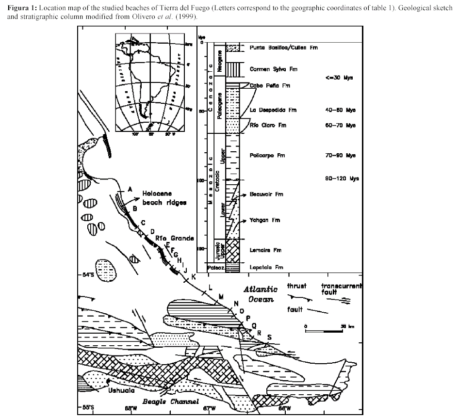
Figura 1: Location map of the studied beaches of Tierra del Fuego (Letters correspond to the geographic coordinates of table 1). Geological sketch and stratigraphic column modified from Olivero et al. (1999).
Several Tertiary formations have been described at the Eastern Grande Island. Seven formations: Strata of Río Claro, Río Turba, La Pilarica, Cabo Peña, Cabo Domingo, Cerro Águila and del Castillo were cited in the region (Doello Jurado 1922; Codignotto and Malumián 1981; Buatois and Camacho 1993; Olivero et al. 1999). In the last years, dispersed outcrops were reinterpreted into three sedimentary cycles:
1. The Palaeocene transgression flooded the island from the west (Río Claro Formation; Bautois and Camacho, 1993) and ended during the Eocene (La Despedida Formation; Doello Jurado 1922).
2. The second transgression originated from the Atlantic Ocean and is constituted by the Cabo Inés strata (informal stratigraphic unit) assumed as Oligocene and correlated to the Cabo Peña Formation (Bautois and Camacho 1993).
3. The third transgression affected only the northern portion of the island and initiated as the Cerro Águila Conglomerate, continuing into the deltaic sediments of the Carmen Silva and Castillo formations (Codignotto and Malumián 1981).
There was a fourth transgression of little duration and extension (Punta Basílica Sandstone) correlated to the Filaret formation from Chile and assigned to the Upper Miocene - Lower Pliocene (Codignotto and Malumián 1981). These transgressions have similar counterparts (within the same Austral Basin) in the Santa Cruz sector (Russo et al. 1980; Codignotto and Malumián 1981). Pleistocene glacigenic units of different ages and environments overlay the Tertiary sediments (Bujalesky et al. 2001).
In most cases, the base of these beaches is an abrasion platform cut into Tertiary rocks. As these Tertiary rocks are closer to the Cordillera, they are more affected by faults. The southern beaches of Tierra del Fuego are located between capes designed by transform fault zones subject to frequent earthquakes (Fig. 2).
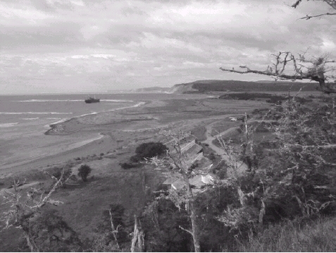
Figura 2: The coast at the Ladrillero estuary is a pocket beach between two capes rounded by the Pleistocene glaciations. The river meanders o a plain dominated by Sphagnum peat. The outlet is permanently blocked by an accumulation of gravel and sand. The river seeps at the upper beach (about 40 m width) during low tide. The Cabo San Pablo lighthouse became tilted on the earthquake of 1949.
The climate of Tierra del Fuego is dominated by the prevailing westerly winds, with Pacific cyclones moving eastwards but not far from the Antarctic ice (Tuhkanen 1992). The Cordillera de Los Andes causes a climatic step from west to east, and from south to north (Fig. 1). Rainfall is more subject to topographic effects: while Rio Grande and Ushuaia have similar mean annual temperatures of 5-6° C, precipitation at Ushuaia sums 534.7 mm/year (it has been diminishing since 1928-1937; R. J. Iturraspe, personal communication); and in Río Grande is only 340 mm/year (Bujalesky 1998). Prevailing winds are also subject to topographic effects: in the region of the Magellan Strait they blow from the west and northwest; in Río Grande city they prevail from the west, and in Ushuaia they are from the southwest. Spring and summer are the most windy seasons (Bujalesky 1998).
At the Atlantic coastline, mean tidal range diminishes toward the southeast: 6.6 m in San Sebastián Bay, 5.7 m in Caleta La Misión, 4.16 m in Rio Grande outer estuary and 4.63 m in Caleta San Pablo (Fig. 1). Maximum tidal currents are over 2 knots (either during the flood or ebb) at the inlet of San Sebastián Bay, and of 5 knots within the bay (spring tidal ranges reach 10.4 m).
Wave climate is relatively benign at the Atlantic coast due to the dominance of the strong westerly winds. Reports from the British Meteorological Office, covering a sea area from the coast to longitude 65° W and between latitudes 50° and 55° S (period 1949-1968), indicates:
(a) the frequency of wave heights higher than 3.5 m is very low;
(b) around 20% of waves were less than 1 m in height on average throughout the year;
(c) long-period waves are relatively uncommon; and wave with periods greater than 10 seconds come from the east and northeast;
(d) gales of 41-47 knots from any direction between N and ESE (with a return period of 50 years) are estimated to generate an extreme wave height of 12 m and a period of 11.5 seconds in a depth of 50 m (referred to spring tide level);
(e) this estimated extreme wave would break in a water depth of 15 m (chart depth + tidal height above chart datum + storm surge), and would be near the breaking point in 10 m depth even at spring high water.
A record of one year at Estancia Cullen (52°49'19" S, 68°13'52" W, 110 km north of the city of Rio Grande) gave the following results:
(a) a maximum wave height of 5,86 m (Compagnie de Recherches et d'Etudes Oceanographiques and Geomatter 1985);
(b)maximum significant wave height was 3,43 m;
(c) average significant wave height was 1,02 m;
(d) maximum wave period recorded was 17,5 seconds;
(e) maximum significant period was 12,9 seconds;
(f) average significant period was 5,5 seconds;
(g) waves higher than 3 m corresponded to periods of 7 to 9 seconds;
(h) the longer periods were associated with wave heights of 1,25 m;
(i) the stronger swell is associated with north and northeast winds;
(j) the estimated extreme wave height would be 5,8 m for NE to E winds and 7 m for winds from the north for a return period of 50 years.
In San Sebastián Bay, extreme winds higher than 64 knots were estimated from the SW and NW (Compagnie de Recherches et d'Etudes Oceanographiques and Geomatter; 1985) for recurrence periods of 50 years. These conditions would produce maximum significant waves of 2,74 m originated within the bay.
Sediment sources and beach drift
In northern Tierra del Fuego, beach gravel is provided from the reworking of glacial, glacifluvial or former coastal deposits (Bujalesky 1998; Bujalesky et al. 2001). In some places the source of sediments are ancient moraines today submerged (Isla and Schnack 1995). Sand is provided by fluvial or eolian processes, by the reworking of beach plains (Isla and Bujalesky 2000) or coastal erosion from Tertiary cliffs.
The bimodal beaches of Tierra del Fuego are directly or indirectly related to glacigenic sources. Different glaciations affected the area (Rabassa et al. 1992); the oldestmost is of Upper Pliocene age (Drift Río Grande; sensu Meglioli et al. 1990) and the most recent (Bahía Inútil Glaciation) was limited to the southern flank of the Carmen Sylva hills, and has a Wisconsinan age (isotopic stage 5e) with some ice advances (see Mc Culloch and Bentley 1998). Two glacifluvial delta systems were recognised. The oldest one is Pleistocene and located between 10 and 50 m over MSL (the lowermost). The most recent is settled at a higher altitude (50-100 m) and limited to the western area of northern Tierra del Fuego (Bujalesky et al. 2001).
A regional longshore drift has been reported from north to south in regard to coastal features and sediment transport experiments (Codignotto and Malumián 1981; Isla et al. 1991). However, beach heavy minerals suggest that present longshore transport is from south to north (Gomez Peral and Martinez 1997). Based on ancient aerial photographs, Bujalesky (1997) described the evolution of the recurving Popper Spit (Rio Grande Inlet) in response to a local drift from south to north. Refraction diagrams explained how this local drift is caused by the refraction of waves induced by rocky reefs (Gusano and Exterior reefs; Isla and Bujalesky 2000).
Morphodynamics of sand and gravel beaches
Although the stability field of bedforms composed by sand is rather well known, some gravel steep bedforms are reported with doubts whether they form by lower or upper regimes (Carling 1999). Sandy macrotidal beaches often have concaveupward profiles (Masselink and Hegge 1995). Gravel beaches are concave-upward, but the upper beach is convex-upward due to the development of berm crests at the high-tide level. Bluck (1967) studied the distribution of sediments on a beach composed mainly of gravel and discriminated four facies: the zone of large discs (transported to the higher altitudes by storms) , the imbricate zone (smaller clasts dipping to the sea), the infill zone and the outer frame zone (dominated by spherical clasts). Eolian processes can dominate the upper beach during low tide or neap tides (Masselink and Hegge 1995). The upper part of gravel beaches is only modified during spring high tides or storms. Overtopping is an episodic process commonly recognised in gravel beaches (Orford et al. 1995). Seepage could induce the capture of eolian sand (at the low-tide terraces and/or on the foreshore) in sandy beaches. In gravel beaches, the seepage could be an important process (Carter et al. 1984), causing gravel transport down the beach profile and deposition as seepage deltas (Isla et al. 1991). During neap tides, the retreating erosion of the seepage portion causes a sediment transport down the beach, and thinning the body of the barrier. During spring tides, waves transport gravel towards the beach crest, due to the reflective behaviour of the beach, reconstituting the dynamic profile.
Unimodal beaches can be modelled by uniform parameters (Short 1979; Wright et al. 1982; Wright and Short 1984; Masselink and Short, 1993) that depend on breaker height (Hb), wave period (T) and settling velocity of the particles (Ws). The W parameter (Hb/Ws T) and the Relative Tidal Range (RTR=MSR/Hb) define the beach morphodynamics (MSR: mean spring tidal range). Beach slopes are related to the grain size and to wave action. Sunamura (1984) proposed an approximation for microtidal beach slopes (tan B)
tan B = 0,12 (Hb/g 0,5 T . d0,5) 0,5
where g is the acceleration due to gravity, and
d is the grain size.
For bimodal beaches, the relationship between slope and grain size is not clear (Mc Lean and Kirk 1968). Their sediment transport prediction depends on the understanding of inter-related factors (Mason and Coates 2001). For meso and macrotidal beaches, and considering them composed of fine to medium sand, the relationships are less easy; some characteristics can be explained in relation to dominant processes in the different beach zones:
a) the upper intertidal zone is dominated by swash and aeolian processes,
b) the mid-intertidal zone is dominated by swash and surf,
c) the lower intertidal zone is controlled by surf and shoaling wave processes, and
d) the subtidal zone is subject to shoaling processes (Masselink and Hegge 1995).
Many beaches of England are presently and preferably being nourished with gravel as it is more resistant to erosion. However, many doubts arise about their stability as:
a) there is no ideal profile assigned for mixed beaches,
b) no onshore or offshore losses can be predicted,
c) uncertainity about their behaviour in relation to coastal structures, and
d) seepage effects (Mason and Coates 2001).
Methods
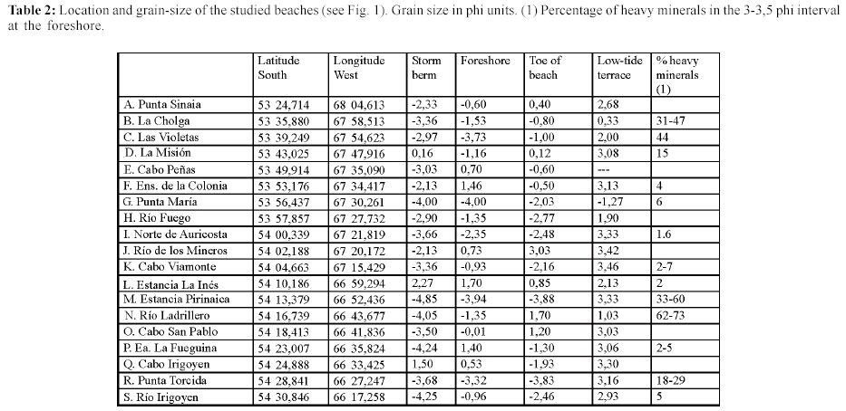
Gravel beach plains were recognised by the mean of aerial photographs and Lansat TM images, and surveyed with teodolite. Beach profiles were executed using teodolite and ruler during low tide. At the field, beaches and beach plains were positioned by a hand-held GPS equipment Ensign Trimble XL (Table 1 and 2). Grain size samplings were conducted according to morphodynamic criteria. Foreshore samples were tested for heavy mineral concentrations. The 3- 3,5 phi intervals were submerged into a heavy liquid (Carbon tetrachlorine) in order to separate and evaluate (by weights) the heavy and light minerals fractions (Table 2).
Table 1: Morphological parameters of Holocene beach-ridge plains (modified from Isla and Bujalesky. 2000). momsl: meters over mean sea level. D: mean grain size at the foreshore. Sublittoral slope is measured at the inner shelf.

Table 2: Location and grain-size of the studied beaches (see Fig. 1). Grain size in phi units. (1) Percentage of heavy minerals in the 3-3,5 phi interval at the foreshore.
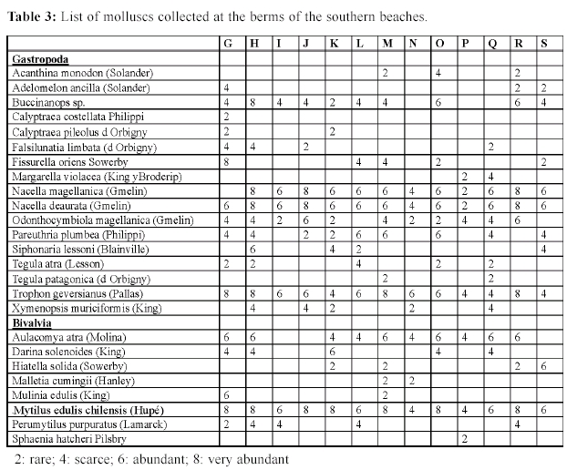
Molluscs were collected from the tidal and storm berms of the southern beaches (Table 3) where beach drift effects are lower (pocket beaches). Mollusc taxonomy were determined according to Castellanos (1989, 1992 a and b, 1993) and Castellanos and Landoni (1988, 1989, 1992 a and b).
Table 3: List of molluscs collected at the berms of the southern beaches.
Results
Beach-ridge plain topography
Beaches from the northern portion of the island derived from the reworking of beach-ridge plains of Holocene age. From north to south, several beach-ridge plains were analysed (Isla and Bujalesky 2000), some are related to river plains: San Sebastián (Rio San Martín), Rio Chico, Cabo Peñas, Ensenada de la Colonia, Rio Fuego, and Rio Ewan (Fig. 3). From NW to SE, beach ridge plains are shorter and narrower (see Table 1). This is explained by the landscape morphology: the northern area has less hills with plains developed by the former action of piedmont glaciers. In the southern area, the relief is higher (hills higher than 50 m) and river valleys are narrower.

Figura 3: Topographic profiles from beach ridge plains: San Sebastián, Rio Chico, Cabo Peñas, Ensenada de la Colonia, Río Fuego and Rio Ewan (locations in Fig. 1).
Beach morphology and morphodynamics
At some beaches related to beach plains and subject to wind action, low coastal dunes can be recognised (Cabo Peñas, Ensenada de la Colonia). From Punta María (G in fig. 1) to the south, the beaches are at the foot of high cliffs. Some beaches are related to spits blocking estuaries (Rio Fuego, Ladrillero, Río Irigoyen). Along these beaches longshore drift selection of different sizes can be expected.
Beach profiles (Figs. 4 to 6) indicate two different zones: the foreshore and the low-tide terrace. These profiles do not fit into the three classes of sandy macrotidal beaches described by Short (1991). The foreshores have very uniform slopes higher than 6%. The low-tide terraces have slopes of less than 2% (Fig. 7). Some beaches show convex-upward profiles due to the development of crest berms. Three crests can be distinguished in these beaches: the storm berm, the spring-tide berm and the present tidal berm (subject to changes in relation to the present-day dynamics). Different relationships exist between the slopes of the upper beaches and their grain sizes (Fig. 7): north of profile L (Ewan river estuary) beaches are the response of the reworking of gravel beach plains. On the other hand, southern beaches are located between capes composed of Tertiary rocks with glacigenic deposits on top of coastal cliffs.
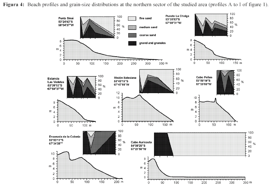
Figura 4: Beach profiles and grain-size distributions at the northern sector of the studied area (profiles A to I of figure 1).

Figura 5: Beach profiles and grain-size distributions at the central sector of the studied area (profiles J to N).

Figura 6: Beach profiles and grain-size distributions at the southern sector of the studied area (profiles O to S).

Figura 7: Relationships between mean grain size (phi units) and intertidal slopes (%). There is a significant relationship at the foreshore, while there is no relation within the low-tide terrace.
As on gravel beaches Hb varies during the tide (up to 100%), the relationship W/RTR cannot be applied. Gravel beaches have a reflective behaviour at high tide and dissipative at low tide. These processes were already noted by Wright and Short (1984).
Grain size
The storm berms are dominated by oblate or tabular pebbles usually larger than 4 mm (Table 2). Upper foreshores are composed dominantly of pebbles, granules or coarse sand (Fig. 7). Where the availability of different materials is significant there is a grain-size selection into sand runs, gravel segregations or even shell accumulations. The lower foreshore and the toe of the beach are also composed of pebbles, granules or coarse sand. The low-tide terraces are dominated by fine to very fine sand. Only on few beaches, abrasion platforms were recognised (Rio Irigoyen).
Plotting grain size (in phi units) versus beach slope (%), we can distinguish a significant linear correlation for the data obtained from the upper foreshores (Fig. 7). The differences for the foreshore grain sizes between the northern and southern beaches were attributed to inherited conditions as the degree of reworking and sorting. At the low tide terraces composed of fine sand, there is no relation to their gentle slopes. These results confirm the conclusions of Mc Lean and Kirk (1968) for New Zealand beaches, that there are no clear relationships between beach slope and mean grain size in bimodal beaches.
Heavy-mineral distribution
The heavy mineral content in the 3-3,5 phi interval ranged between 2 and 73%. Two areas were distinguished as of interest by their values: The first one is the area between La Cholga and Las Violetas sampling stations (percentages between 31 and 47%). It belongs to the Río Chico beach ridge plain, and was already tested for placers (Gómez Peral and Martínez 1997). Another area of interest was recognised at the coastline between Estancia Pirinaica and the Río Ladrillero estuary, with values between 33 and 73% (Table 2).
Mollusc distribution
In present beaches no trend was analysed in relation to the different mollusc species found. Nacella magellanica, Nacella deaurata, Trophon geversianus, Mytilus edulis chilensis, Aulacomya atra were the most abundant species; Tegula atra, Tegula patagonica, Hiatella solida were found in lower percentages (Table 3). Considering the preferences of theses mollusc assemblages to rocky- or soft-bottom substrates, it is concluded that more specimens related to rocky bottoms were found at capes: Punta María, Viamonte, Santa Inés, San Pablo and Irigoyen capes (Fig. 8).

Figure 8: Abundance of mollusc specimens collected at the berms (beaches coded by the letters of table 1).
Discussion
Little is known about macrotidal bimodal or «mixed» beaches (Mason and Coates 2001). Their dynamics is complicated by processes acting in different ways along space and time (i.e. during high or low tide). Sediment composition is subject to many different processes: overtopping, gravel armouring, sand sieving, water seeping and size and shape segregations. The upper foreshore slope is conditioned by gravel size; the grain size of low-tide terraces seems to be controlled by inherited factors. This causes a dissipative behaviour at low tide changing abruptly to reflective at mid- or high tide (Wright and Short 1984; Mason and Coates 2001).
The origin of beach ridge plains is not precisely understood: some authors assigned them to fair-weather conditions while those composed of coarse sediments are assumed formed by storms (Taylor and Stone 1996). Tropical beach-ridge plains are clearly related to significant inputs from big rivers (Anthony 1995). The sea level should remain stable or dropping (Short 1987; Anthony 1995; Hesp and Short 1999). In the coast of New Zealand, the glacioeustatic evolution and the availability of sand and gravel permit the development of gravel beach plains (Schulmeister and Kirk 1993; Soons et al. 1997) similar to these of Tierra del Fuego.
Heavy mineral studies pretended to analyse the origin of the gold placers exploited at the beginning of the XX century by Julius Popper. Modern studies carried out along the coastline of the Río Chico beach plain proposed a fluvial origin for the beach heavy mineral concentrations (Gómez Peral and Martinez 1997). However, the El Páramo and Rio Chico barriers, composed by sand and gravel, clearly derived from the glacial deposits outcropping at the coast (Cabo Nombre, Punta Sinaia) and at the shallow inner shelf (Isla et al. 1991; Isla et al. 1995). At the coast of Alaska (Seward Peninsula), the nearshore deposits in front of the village of Nome (between the Snake and Nome rivers) contained gold placers. The surface sediments with the highest gold content were the relict lag gravel that veneers glacial drift at the depth of less than 10 m. The largest particles (several mm in diameter) were therefore related to relict gravel over the submerged drift (Nelson and Hopkins 1972).
Macrofaunal species richness in beaches is controlled by their dynamics, increasing from reflective to dissipative conditions, and in response to the maximum tidal range (Mc Lachlan 1990). More precisely, swash climate has been assigned as the crucial effect. Dissipative swash conditions require minimal faunal adaptations while reflective beaches are more hostile, demand more specializations and exclude more species (Short and Hesp 1999).
Conclusions
1. In Eastern Tierra del Fuego, southern portion of the South American Plate, inherited factors related to tectonics permit the development of beach ridge plains in the north in response to the Holocene sea level fluctuation. This fluctuation eroded cliffs at the southern coast of the island (Scotia Microplate domain), but there was not enough sediment in order to construct wide plains during the last 6000 years.
2. In macrotidal bimodal (gravel and sand) beaches, it is clear that the slope of the foreshore is controlled by the gravel size. The grain size of the low-tide terrace is conditioned by an inherited factor, i.e. the availability of sand.
3. Spits denote the effects of beach drift at the northern coast. The southern coast is characterised by pocket beaches and sand accumulation at river outlets.
4. On the northern beaches the availability of sediment is directly related to the reworking of beach ridge plains. South of the Cabo Irigoyen, the availability of sand is conditioned to the erodability of the different Tertiary units or provided by Quaternary piedmont glaciers.
5. Two segments of the coast were recognised as relatively rich in beach heavy minerals: La Cholga - Las Violetas and Estancia Pirinaica - Ladrillero estuary.
6. Considering the mollusc composition of theses beaches, rocky-bottom specimens dominate at the beaches between capes.
Acknowledgements
R. Angulo (Universidade Federal do Paraná, Curitiba) participated during the field works in 1998. Susana Serra performed the grain-size analysis. M. Farenga did the draftings. This paper was granted by CONICET (PIP 4383) and Fundación Antorchas (grant 13672/6). E. Schnack and G. Perillo made useful comments as reviewers of this journal.
Works cited on the text
Anthony, E. J. 1995. Beach-ridge development and sediment supply: examples from West Africa. Marine Geology 129: 175-186. [ Links ]
Bluck, B.J. 1967. Sedimentation on gravel beaches: examples from the south of Wales. Journal Sedimentary Petrology, 37: 128-156. [ Links ]
Buatois, L.A. and Camacho, H.H. 1993. Geología del sector nororiental del Lago Fagnano, Isla Grande de Tierra del Fuego. Revista de la Asociación Geológica Argentina, 48(2): 109-124. [ Links ]
Bujalesky, G. 1997. Morfodinámica y evolución histórica de la espiga Punta Popper y la boca de mareas del río Grande, Tierra del Fuego. Revista de la Asociación Geológica Argentina, 52(2): 187-201. [ Links ]
Bujalesky, G. 1998. Holocene coastal evolution of Tierra del Fuego, Argentina. Quaternary of South America & Antarctic Peninsula, 11: 247-282, Balkema Publishers. [ Links ]
Bujalesky, G.G., Coronato, A.M., Roig, C. and Rabassa, J. 1994. Forma de rodados de ambientes glacigenicos del Pleistoceno y costeros actuales del Lago Fagnano, Tierra del Fuego. Revista de la Asociación Geológica Argentina, 49(1-2): 154-164. [ Links ]
Bujalesky, G., A., Coronato and Isla, F. 2001. Ambientes glacifluviales y litorales cuaternarios de la región de Río Chico, Tierra del Fuego, Argentina. Revista de la Asociación Geológica Argentina, 56(1): 73-90. [ Links ]
Caldenius, C. C. 1932. Las glaciaciones cuaternarias en la Patagonia y Tierra del Fuego. Geografiska Annaler XIV, 1-2, 164 p. [ Links ]
Carter, R.W.G., Johnston, T.W. and Orford, J.D. 1984. Stream outlets through mixed sand and gravel coastal barriers: examples from the Southeast Ireland. Z. fur Geomorphologie, v. 28(4): 427-442. [ Links ]
Carling, P.A. 1999. Subaqueous gravel dunes. Journal Sedimentary Research, 69(3): 534-545. [ Links ]
Castellanos, Z. 1989. Catálogo descriptivo de la malacofauna magallánica. 4. Mesogastropoda. Comisión de Investigaciones Científicas de la Prov. de Buenos Aires, 43 p., La Plata. [ Links ]
Castellanos, Z. 1992a. Catálogo descriptivo de la malacofauna magallánica. 7. Neogastropoda. Comisión de Investigaciones Científicas de la Prov. de Buenos Aires, 40 p., La Plata. [ Links ]
Castellanos, Z. 1992 b. Catálogo descriptivo de la malacofauna magallánica. 8. Neogastropoda . Comisión de Investigaciones Científicas de la Prov. de Buenos Aires, 27 p., La Plata. [ Links ]
Castellanos, Z. 1993. Catalogo descriptivo de la malacofauna magallánica 9. Neogastropoda. Comisión de Investigaciones Científicas de la Prov. de Buenos Aires, 25 p., La Plata. [ Links ]
Castellanos, Z. and Landoni, N. 1988. Catálogo descriptivo de la malacofauna magallánica. 2. Archigastropoda. Comisión de Investigaciones Científicas de la Prov. de Buenos Aires, 40 p., La Plata. [ Links ]
Castellanos, Z. and Landoni, N. 1989. Catálogo descriptivo de la malacofauna magallánica 3.Trochidae y turbinidae (Archigastropoda). Comisión de Investigaciones Científicas de la Prov. de Buenos Aires, 40 p., La Plata. [ Links ]
Castellanos, Z. and Landoni, N. 1992a. Catálogo descriptivo de la malacofauna magallánica 10. Neogastropoda. Comisión de Investigaciones Científicas de la Prov. de Buenos Aires, 42 p., La Plata. [ Links ]
Castellanos, Z. and Landoni, N. 1992b. Catálogo de la malacofauna magallánica 11. Neogastropoda. Comisión de Investigaciones Científicas de la Prov. de Buenos Aires, 31 p., La Plata. [ Links ]
Compagnie de recherches et d' etudes oceanographiques-geomatter, 1985. Campagne meteo-oceanographique, site Río Cullen/Hydra, periode de Fevrier 1984 a Fevrier 1985. Technical Report CREO/ 1249, TOTAL AUSTRAL, Buenos Aires, Argentina, 399p. Unpublished. [ Links ]
Codignotto, J. O. and Malumián, N. 1981. Geología de la región al norte del paralelo 54° Sur de la Isla Grande de la Tierra del Fuego. Revista de la Asociación Geológica Argentina 36 (1): 44-88, Buenos Aires. [ Links ]
Coronato, A., Salemme, M. and Rabassa, J. 1999. Palaeoenvironmental conditions during the early peopling of Southernmost South America (Late glacial-Early Holocene, 14-8 ka B.P.) Quaternary International, 53/54: 77-92 . [ Links ]
De Ferraris, C.1938. Observaciones en Tierra del Fuego (resumen). Boletín de Informaciones Petroleras, 171: 43-44. [ Links ]
Doello Jurado, M. 1922. Note préliminaire sur les résultats géologiques de l'Expédition de l´Université de Buenos Aires à la Terre du Feu , 1921). Congrès Géologique International, Compte rendu XIII session, Belgique, Liège, 3: 1519-1520. [ Links ]
Feruglio, E. 1950. Descripción Geológica de la Patagonia. Ministerio de Industria y Comercio de la Nación, Dirección General de Yacimientos Petrolíferos Fiscales. 3: 1-141.Buenos Aires. [ Links ]
Gomez Peral, M. A. and Martinez, D.E. 1997. Distribución de minerales pesados en playas del litoral atlántico de la Tierra del Fuego, entre Cabo San Sebastián y Cabo Domingo. Revista de la Asociación Geológica Argentina, 52(4): 504-514. [ Links ]
Gordillo, S. 1998. Distribución biogeográfica de los moluscos Holocenos del litoral Argentino-Uruguayo. Ameghiniana 35(2): 163-180. [ Links ]
Hesp, P. A. and Short, A. D. 1999. Barrier morphodynamics. In Short, A. D. (ed.) Handbok of beach and shoreface morphodynamics. John Wiley and sons, Ch. 14: 307-333. [ Links ]
Isla, F. I. 1994. Evolución comparada de bahías de la Península Mitre, Tierra del Fuego. Revista de la Asociación Geológica Argentina 49 (3-4): 197-205. [ Links ]
Isla, F.I. and Bujalesky, G.G. 2000. Cannibalisation of holocene gravel beach plains, northern Tierra del Fuego, Argentina. Marine Geology, 170(1-2): 105-122. [ Links ]
Isla, F. I. and Schnack, E. J. 1995. Submerged moraines offshore Tierra del Fuego, Argentina. Quaternary of South America and Antarctic Peninsula, 9: 205-22. [ Links ]
Isla, F. I., Vilas, F. E., Bujalesky, G., Ferrero, M., González Bonorino, G. and Arche Miralles, A. 1991. Gravel drift and wind effects over the macrotidal San Sebastián Bay, Tierra del Fuego. Marine Geology, 97: 211-224. [ Links ]
Mason, T. and Coates, T.T. 2001. Sediment transport processes on mixed beaches: a review for shoreline management. Journal of Coastal Research 17(3): 645-657. [ Links ]
Masselink, G. and Hegge, B. 1995. Morphodynamics of meso- and macrotidal beaches: examples from central Queensland, Australia. Marine Geology, 129: 1-23. [ Links ]
Masselink, G. and Short, A. D. 1993. The effect of tide range on beach morphodynamics and morphology: a conceptual beach model. Journal of Coastal Research, 9(3): 785-800. [ Links ]
Mc Culloch, R.D. and Bentley, M. J. 1998. Late Glacial ice advances in the Strait of Magellan, Southern Chile. Quaternary Science Reviews, 17: 775-787. [ Links ]
Mc Lachlan, A. 1990. Dissipative beaches and macrofauna communities on exposed intertidal sands. Journal of Coastal Research 6: 57-71. [ Links ]
Mc Lean, R.F. and Kirk, R.M. 1968. Relationship between grain size, size-sorting and foreshore slope on mixed sand-shingle beaches. New Zealand Journal of Geology and Geophysics, v. 12: 138-155. [ Links ]
Meglioli, A., Evenson, E., Zeitler, P. and Rabassa, J. 1990. Cronología relativa absoluta de los depósitos glaciarios de Tierra del Fuego, Argentina y Chile. 11º Congreso Geológico Argentino, Actas 2: 457-460, San Juan. [ Links ]
Nelson, C. H. and Hopkins, D. M. 1972. Sedimentary processes and distribution of particulate gold in the Northern Bering Sea. Geological Survey Professional Paper 689, USGS, 27 p., Washington. [ Links ]
Olivero, E. B., Martinioni, D. R., Malumián, N. and Palamarczuk, S. 1999. Bosquejo geológico de la Isla Grande de Tierra del Fuego, Argentina. 14º Congreso Geológico Argentino, Actas 1: 291-294, Salta. [ Links ]
Orford, J.D., Carter, R.W.G., Jennings, S.C. and Hinton, A.C. 1995. Processes and timescales by which a coastal gravel-dominated barrier responds geomorphologically to sea-level rise: Story Head barrier, Nova Scotia. Earth Surface Processes and Landforms, 20: 21-37. [ Links ]
Rabassa, J. O., Bujalesky, G.G., Meglioli, A., Gordillo, S., Roig, C. and Salemme, M. 1992. The Quaternary of Tierra del Fuego, Argentina: the status of our knowledge .Sveriges Geologiska Undersokning, Ser.C, 8: 249-256. [ Links ]
Russo, A., Flores, M. A. and Di Benedetto, H. 1980. Patagonia Austral Extra Andina. II Simposio de Geología Regional Argentina, Academia Nacional del Ciencias, Córdoba, II, 1431-1462. [ Links ]
Schulmeister, J. and Kirk, R. M. 1993. Evolution of a mixed sand and gravel barrier system in North Canterbury, New Zealand, during Holocene sea-level rise and still-stand. Sedimentary Geology 87: 215-235. [ Links ]
Short, A. D. 1987. Modes, timing and volume of Holocene cross-shore and aeolian sediment transport, Southern Australia. In Coastal Sediments, ASCE, New Orleans, 1925-1937. [ Links ]
Short, A. D. 1979. Three-dimensional beach stage model. Journal of Geology, 87: 553-571. [ Links ]
Short, A. D. 1991. Macro-meso tidal beach morphodynamics. An overview. Journal of Coastal Research, 7(2): 417-436. [ Links ]
Short, A. D. and Hesp, P. A. 1999. Beach ecology. In Short, A. D. (ed.) Handbok of beach and shoreface morphodynamics. John Wiley and sons, Ch. 11: 271-278. [ Links ]
Soons, J.M., Schulmeister, J. And Holt, S. 1997. The Holocene evolution of a well nourished gravelly barrier and lagoon complex, Kaitorete «Spit», Canterbury, New Zealand. Marine Geology 138: 69-90. [ Links ]
Sunamura, T. 1984. Quantitative predictions of beach-face slopes. Bull. Geological Society of America, 95: 242-245. [ Links ]
Taylor, M. and Stone, G. W. 1996. Beach-ridges: a review. Journal of Coastal Research 12(3): 612-621. [ Links ]
Tuhkanen, S. 1992. The climate of Tierra del Fuego from a vegetation geographical point of view and its ecoclimatic counterparts elsewhere. Acta Botanica Fennica, 145: 1-64. [ Links ]
Wright, L.D., Nielsen, P. Short, A.D. and Green, M. O. 1982. Morphodynamics of a macrotidal beach. Marine Geology, 50: 97- 128. [ Links ]
Wright, L.D. and Short, A. D. 1984. Morphodynamics variability of surf zones and beaches: a synthesis. Marine Geology, 56: 93-118. [ Links ]
Recibido: 7 de febrero, 2004
Aceptado: 6 de enero, 2005

