


Servicios Personalizados
Revista

Articulo
 Inglés (pdf)
 Articulo en XML
 Referencias del artículo
 Enviar articulo por email
Indicadores
-
 Citado por SciELO
Links relacionados
-
 Similares en
SciELO
Similares en
SciELO
Compartir

 Permalink
Revista de la Asociación Geológica Argentina
versión impresa ISSN 0004-4822versión On-line ISSN 1851-8249
Rev. Asoc. Geol. Argent. v.61 n.4 Buenos Aires oct./dic. 2006
An Overview of the Main Quaternary Deformation of South America
Costa, C.H.1, Audemard M., F.A.2, Bezerra, F.H.R.3, Lavenu, A.4, Machette, M.N.5 and París, G.6
1 Departamento de Geología, Universidad Nacional de San Luis, Chacabuco 917, 5700 San Luis, Argentina. Email: costa@unsl.edu.ar
2 FUNVISIS, Apartado Postal 76.880, Caracas 1070-A, Venezuela. Email: faudemard@funvisis.gob.ve
3 Departamento de Geologia, Universidade Federal do Rio Grande do Norte, Natal, RN, 59072-970, Brazil. Email: bezerrafh@geologia.ufrn.br
4 Institut de Recherche pour le Développement (IRD-LMTG - UR 154 - UMR 5563 - UPS, Toulouse 3), 14 Avenue Edouard Belin, 31400 Toulouse, France. Email: Alain.Lavenu@ird.fr
5 Earth Surface Processes Team, United States Geological Survey, MS 980, Box 25046, Denver, CO 80225, USA. Email: machette@usgs.gov
6 Departamento de Geografia, Universidad del Valle, Meléndez, Cali, Colombia, Email: gabrielparis@hotmail.com
ABSTRACT
Deformation affecting continental South America during Quaternary is related to the Neogene geodynamic processes. These structures are mainly controlled by anisotropies inherited after a long and complex history as well as by the kinematic and geometric features of the ongoing plate interaction. Main Quaternary structures at both ends of South America are directly linked to plate interaction and some of them are considered to be plate boundaries. The main structures with Quaternary activity along the Caribbean coast have an E-W trend and a strike-slip regime. Between the Venezuelan Andes and the Gulf of Guayaquil, NE trending structures are dominant, with a kinematic regime ranging from strike-slip to transpressive and compressive. At the Central Andes (4ºS-46º30'S) most Quaternary deformation results from a complex stress distribution and stress-partitioning at the interior of the South American plate, reactivating preexisting discontinuities. The present geometry of the subducted Nazca plate is here the main control with respect to the distribution and characteristics of Quaternary deformation, being them better exposed at the Andean eastern slope and foreland regions. The main structure with Quaternary activity at the southernmost Andes is represented at Tierra del Fuego by a left-lateral transform boundary, resulting from the South American and Scotia plate interaction.
Keywords: South America; Quaternary deformation; Neotectonics.
RESUMEN
Una perspectiva sobre las principales deformaciones cuaternarias de América del Sur. Las deformaciones que han afectado al sector continental de Sudamérica durante el Cuaternario aparecen vinculadas con los procesos geodinámicos dominantes durante el Neógeno. Las mismas están principalmente controladas por las anisotropías heredadas de una prolongada y compleja historia evolutiva y por las características cinemáticas y geométricas que caracterizan a la interacción actual de placas. Las principales características de la tectónica cuaternaria en los extremos norte y sur de Sudamérica, derivan en forma directa de las interacciones entre bordes de placas, constituyendo muchos de estos rasgos estructurales los límites entre las mismas. A lo largo de la costa Caribe las principales estructuras con actividad durante el cuaternario exhiben principalmente una orientación E-O y régimen transcurrente. Entre los Andes venezolanos y el golfo de Guayaquil predominan estructuras con orientación NE y una cinemática variable entre regimenes transcurrentes, transpresivos y compresivos. En los Andes Centrales (4ºS-46º30'S) la mayoría de las deformaciones cuaternarias resulta de una compleja distribución y partición de esfuerzos en el interior de la placa Sudamericana, reactivando discontinuidades preexistentes. La expresión superficial de este tipo de deformaciones está mejor representada en la pendiente oriental andina y sectores adyacentes del antepaís. Aquí, la geometría actual de la subducción de la placa de Nazca representa el principal control respecto a la distribución y características de las deformaciones cuaternarias. La principal estructura con actividad cuaternaria en el sector andino austral, está representada por un borde transformante con componente sinestral en Tierra del Fuego, resultante de la interacción entre las placas de Sudamerica y de Scotia.
Palabras clave: América del Sur; Deformaciones cuaternarias; Neotectónica.
INTRODUCTION
During the last two decades the significance of recent deformation for seismic-hazard analysis and other applications has often been highlighted as a relevant contribution by geological sciences to these critical issues. Seismicity has traditionally been used to characterize some potentially hazardous faults, especially along active plate margin settings. However, faulting events related to recent earthquakes have shown that much of the deformation away from active plate margins occurs along faults with no significant level of modern seismicity and that only a fraction of Quaternary faults are characterized by ongoing seismicity. Most of the seismic hazard in continental South America (inboard from the subduction zone) is related to shallow intraplate crustal seismicity. Thus, developing information on Quaternary faulting should help extend the short time span provided by records of historical and instrumental seismicity into prehistoric time (i.e., the late Quaternary). This longer time span would allow making better assessments of seismic potential and identifying the likely spatial and temporal distribution of future damaging earthquakes.
The state of knowledge of Quaternary deformation in South America is neither homogeneous nor complete. In most cases the information is of a reconnaissance nature, largely based in remote- sensing interpretation and general fieldwork. Many faults have slip rates that are lower than sedimentation and/or erosion rates. Considering that neotectonic analysis is commonly based on geomorphic features that may be related to recent deformation, this kind of approach may identify more inactive features than active ones. Therefore, distinguishing between active control and passive control of structures in the landscape is crucial for successfully identifying a feature with Quaternary activity.
The other issue which hampers a reliable and accurate neotectonic analysis is the limited knowledge of Quaternary chronologies. Regional temporal analyses rely on the recognition of morphostratigraphic units, which are commonly vaguely referred to as Quaternary, such as piedmont deposits or landforms, alluvial deposits, basin fill sediment, etc.
The term ¨neotectonics¨ has a floating time frame, even in the specific literature (Mercier 1976, Fairbridge 1981, Vita Finzi 1987, Hancock 1988, Pavlides 1989, Mörner, 1994), as well for different interpretations in South America. For some it is synonymous to "Quaternary Tectonics", whereas for others it refers to tectonic processes that have occurred since Miocene- Pliocene times (perhaps as much as 25 Myr). In order to provide a more specific time frame to "neotectonics" and despite the problems outlined above, this article will focus on the Quaternary tectonics of South America. This time interval is more suitably considered to include 1). features resulting from the active (modern) stress field; 2) structures related to recent/ ongoing topographic changes or mountain building and 3) structures that have produced earthquakes in the past and have the capability of producing earthquakes in the future, thus posing a threat in terms of seismic hazard.
Except for a few cases, there are little reliable information on slip rates, kinematics and paleoseismic record for South American faults. However, three main categories of slip rates can be established from the tectonic setting and some recent results derived from GPS data (Freymueller et al. 1993, Kellog and Vega 1995, Norabuena et al. 1998, Bevis et al. 2001, Kendrick et al. 1999, 2001, Weber et al. 2001, Pérez et al. 2001, Brooks et al. 2003):
Slip rates higher than 5 mm.yr-1: These occur on faults related to onshore plate-interaction, such as the Boconó fault system in Venezuela and probably the Magallanes- Fagnano fault zone in Chile-Argentina, or on subduction zones megathrusts such as the type commonly located off the western coast of South America.
Slip rates between 1-5 mm.yr-1: These occur on faults related to stress-partitioning or to major tectonic-terrane boundaries (i.e, Cordillera Blanca -Peru-, Atacama -Chile-, El Tigre-Argentina-, Ibagué -Colombia-, Oca- Ancón -Venezuela).
Slip rates lower than 1 mm.yr-1: These occur on most intraplate faults within the interior of South America.
There is no general agreement about when a fault should be considered "active" and most definitions put forth are based on the tectonic setting, type of study and type of data available, and/or the author´s perception of the problem. Moreover, geologic scenarios of Quaternary deformation vary from very active plate boundaries to virtually stable cratonic areas, where instrumental seismicity generally has little correspondence with morphotectonic features. In areas where structures portray long recurrence intervals and very slow slip rates, faults with the shortest elapsed time since the last rupture (those considered most "active"), might not be the most hazardous in terms of seismogenic capability (Machette 2000, Costa 2004). Thus, the well engrained term "active fault" is not considered suitable and could even be misleading in terms of objective and homogeneous mapping legends and accurate outreach.
Accordingly, characterizing deformation based on the time since the last-recorded fault slip (i.e., faults with late Quaternary, Holocene or Historic displacement) is considered more suitable than characterization as active, capable, potentially active, inactive fault, and so on. This time-based categorization allows some flexibility in reporting among different tectonic settings or countries owing to the differing complexities or levels of investigation and abilities to date prehistoric faulting events.
HISTORICAL SCOPE
The development of systematic and regional neotectonic studies in South America is quite recent. Except for specific reports spurred by earthquakes having surface deformation and other reconnaissance studies for critical facilities, there are few references to mapping Quaternary deformation on a regional basis (see for example, Saint Amand and Allen 1960, Arabasz 1968, Okada 1971, Soulas 1978, Iriondo and Suguio 1981, Lavenu 1981, Sébrier et al. 1982, Lavenu 1986). Venezuela has been the leading country in developing regional neotectonic maps starting in the early 1980s (Schubert 1979, 1980a, 1980b, 1982, 1984, Soulas 1986). At the same time, international projects such as IGCP 202 and IGCP 206 promoted studies of many Quaternary faults of South America.
Also in the mid-1980s the Preliminary Neotectonic Map of South America was compiled under the framework of the SISRA Project (González-Ferrán 1985), being the first contribution of this type. This map depicted Quaternary faults, although with a strong bias toward seismology.
The launching of the International Lithosphere Program II-2 (World Map of Major Active faults) during the 1990s (Trifonov and Machette 1993), provided a more ambitious effort to develop digital country or regional maps and inventories of Quaternary faults for the Andean countries and Brazil (Audemard et al. 2000, Costa et al. 2000a, Lavenu et al. 2000, París et al. 2000, Saadi et al. 2002, Egüez et al. 2003, Macharé et al. 2003). When this project was completed, Costa et al. (2003) undertook further development of a dynamic, computer database. The ILP II-2 Project meetings allowed many researchers with different backgrounds to meet and discuss common approaches for studying active deformation along a wide variety of tectonic settings, with the aim of achieving homogeneous mapping. A considerable part of the compilation presented in this article is based on information resulting from that decadelong effort.
GENERAL TECTONIC SETTING
As a response to complex, contemporary geodynamical processes, the distribution of neotectonic strain is not homogeneous in continental South America and accordingly Quaternary deformation is concentrated along the more than 8.000 km of the Andean orogen (Fig. 1). The patterns and discontinuities of the Andes orogen, which are inherited from a long and complex evolution and terrane history as well as the present plate tectonic setting, cause a wide variety of neotectonic deformation in terms of both styles and geographical occurrences.
Figure 1: Main neotectonic settings and geotectonic features of continental South America and surrounding areas. 1. Northern Andes; 2. Central Andes; 2A. Peruvian flat-slab; 2B. Normal subduction segment; 2C. Pampean flat-slab.
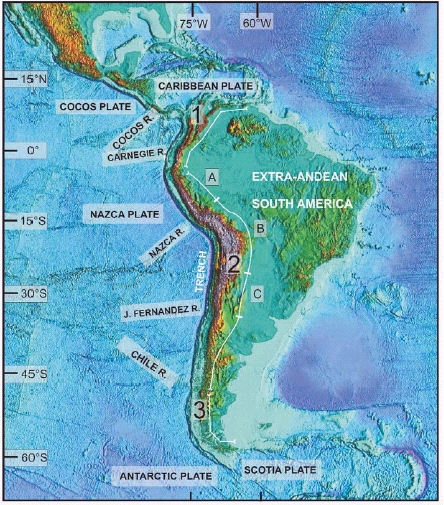
At a continental scale, South American neotectonics is characterized by a dominance of E-W trending strike-slip faulting at the northernmost and southernmost ends owing to plate interactions. On the other hand, Quaternary deformation is fueled by different and variable sources such as strain release related to subduction in a large part of its western border and crustal weaknesses in intraplate and stable continental regions.
The main areas of recent faulting and folding have been ascribed to the Andean region including adjacent foreland regions and intraplate extra- Andean South America. The Andes have traditionally been divided into three main sectors, namely the Northern Andes, the Central Andes and the Southern Andes (Auboin et al. 1973, Gansser 1973, Zeil 1979, Ramos 1999 and many others) (Fig. 1).
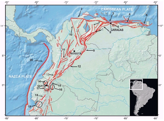
Quaternary fault systems juxtaposing the bounding area between the Northern Andes and continental South America from the Caribbean coast to the Gulf of Guayaquil (Fig. 2) show slip rates higher than mm.yr-1 and a clear association with historical seismicity.
Figure 2: Sketch of main Quaternary deformation along the Northern Andes displaying the following fault and fold systems: 1. Boconó; 2. Oca-Ancón; 3. San Sebastián; 4. El Pilar; 5. Los Bajos-El Soldado; 6. Tacagua- El Avila; 7. San Simón; 8. La Victoria; 9. Eastern Cordillera frontal fault; 10. Santa Marta- Bucaramanga; 11. Ibagué; 12. Algeciras; 13. Romeral; 14. San Isidro-El Angel- Otavalo; 15. Chingual; 16. Payamino-Sumaco- Pusuno-Arajuno; 17. Quito-Nagische- Latacunga-Yanayacu; 18. Pallatanga; 19. Naranjal-Ponce Enríquez; 20. Trench.
Along the Central Andes, the main constraint for grouping and describing Quaternary deformation is the subducting geometry of the Nazca plate. The western slope and coastal areas are direct manifestation of interplate processes and seismicity at the Benioff zone. Related megathrusts are offshore, whereas onshore evidence of Quaternary tectonics are mostly related to coastal tectonics and a few large structures that are being driven by strain partitioning.
At most retroarc areas and at the eastern slope of the Andes, major Quaternary structures are related to crustal weaknesses rather than to interplate processes and crustal seismicity does not necessarily image Quaternary deformation.
Subduction zone segments with a normal subduction angles show noticeable differences in Quaternary occurrence and tectonic style than adjacent flat-subduction segments. Quaternary deformation is more An overview of the main quaternary deformation of South America constrained to the Andean orogen in the former and more efficiently transmitted to the foreland region in the latter (see for example, Jordan et al. 1983a, 1983b, Gutscher et al. 2000).
In contrast, little is known about the Quaternary tectonics of the Southern Andes. The main tectonic settings are here related to oceanic-ridge subduction and a transform interaction between the South America and Scotia plates.
In extra-Andean South America, structures with Quaternary activity are generally located on pre-existing shear zones or weaknesses. They typically have very long recurrence intervals, although recent studies have highlighted their capability of producing surface ruptures as well as liquefaction (Bezerra et al. 1998, Riccomini and Assumpção 1999, Bezerra and Vita Finzi 2000).
QUATERNARY DEFORMATION ALONG THE ANDES AND ADJACENT AREAS
QUATERNARY DEFORMATION AT THE NORTHERN ANDES
The geology and tectonics of the Northern Andes is dominated by a complex interaction between the South American, Caribbean, and Nazca plates. Quaternary deformation is largely concentrated along mountain chains with the dominating structures being reverse and strike slip-faults (Pérez and Aggarwal 1981, Schubert 1982, 1984, Lavenu et al. 1995, Singer and Audemard 1997, Audemard et al. 2000, Taboada et al. 2000, Audemard and Audemard, 2002, Audemard et al., this volume, Lavenu, this volume).
The NE and E-trending megafaults such as the Boconó-San Sebastián-El Pilar fault system in Venezuela (Schubert 1979, 1980a and 1980b), the Eastern Cordillera frontal fault zone in Colombia (Pennington, 1981) and the Dolores-Guayaquil megashear (Campbell, 1974) (Fig. 2) are considered to comprise the long boundary that detaches the Northern Andean Block from the remainder of South America. In fact, the Nor-thern Andes block is bounded by an active right-lateral fault system and dextral motion along these regional faults translated into compressional motion where the faults have a N-S trend; they all accommodate E-W compressional stresses produced by the rapid convergence of the South American and Nazca plates (Fig. 2).
Eastward motion of the Caribbean plate relative to South America drives Quaternary tectonics along northern Venezuela (from Colombia to Trinidad) and determines the dominant strike-slip complex regime of the Oca-Ancón fault system. However a significant part of this dextral slip seems to be currently distributed along the 1200 km-long fault system comprised of the Boconó, San Sebastián, El Pilar, Los Bajos, and El Soldado faults and their southern connections through the Gulf of Guayaquil (Pérez and Aggarwal 1981, Schubert 1980a,b, 1982, Stephan 1982, Aggarwal 1983, Schubert 1984, Soulas 1986, Beltrán and Giraldo 1989, Singer and Audemard 1997, Audemard et al. 2000, Audemard and Audemard 2002, Audemard et al. 2005, Audemard et al., this volume) (Fig. 2). This major strike-slip fault system concentrates the highest slip rates (around 10 mm/yr) along northern South America, as such; many authors have proposed that this fault system constitutes the current plate boundary between the South America and Caribbean plates. This would imply that most part of the Northern Andes is structurally detached from the South American plate (Hess and Maxwell 1953, Schubert 1979, Aggarwal 1983, Soulas 1986 and many others). However, this major issue is still a matter of debate (Audemard et al., this volume).
In particular, the right-lateral Boconó fault has a sinuous trace that traverses the Mérida Andes in Venezuela (Fig. 2), and is flanked on both sides by a series of low-angle thrusts (Audemard 1999). This configuration attests to active strain or stress partitioning in this chain (Audemard and Audemard 2002). Some second-order faults that are diverging or oblique to this major southern Caribbean fault system are interpreted as synthetic Riedel shears, such as the Tacagua-El Avila, Tácata and La Victoria (Audemard et al. 2000, 2005, this volume).
The right-lateral motion related to the Boconó fault system is transferred southward as a complex thrust and strike-slip system into the different strands of the Eastern Cordillera frontal fault system (Paris et al. 2000, Audemard and Audemard 2002). This foreland fold-and-thrust belt overrides the ancient Llanos shield and has shallow, but moderate-to-high levels of seismicity (Aggarwal 1983, Paris and Sarria 1986, Robertson 1989, Sarria 1990, AIS 1996, Audemard 1999, Paris et al. 2000).
There is a general agreement that the Caribbean plate movement (Jordan 1975, Sykes et al. 1978, Duncan and Hargraves 1984) and the southeastward accretion of the Panama-Choco block (Duque-Caro 1980) are the main driving processes of the contemporary tectonics in Colombia (Kellogg and Vega 1995, Paris et al. 2000, Audemard and Audemard 2002). In this sense, Taboada et al. (2000) have proposed that a continental wedge with eastward indentation bounded by the Santa Marta- Bucaramanga fault to the NE and by the Itsmina-Ibagué faults to the south cause ongoing thrusting at the Eastern Cordillera front as well as transpressive deformation at the Santander Massif in Colombia. Within this framework, the Santa Marta-Bucaramanga fault displays Quaternary morphotectonic features (Paris and Sarria 1986) related to sinistral movement (Fig. 2).
The continued eastward subduction of the Nazca plate beneath Colombia induces most of the deep seismicity along the Wadati- Benioff zone (Case et al. 1971, Londsdale and Klitford 1978, Pennington 1981, Gutscher et al. 2000, Taboada et al. 2000). Therefore, southeastward and flatslab subducting geometry of the Caribbean plate (Kellogg et al. 1983) beneath the northern margin of Colombia defines the socalled Bucaramanga flat-slab with low associated seismicity (Ramos 1999). Southward of 3°N, the main Quaternary deformation and related landforms of the Eastern Cordillera frontal fault system are translated into a dominant strike-slip regime through the Algeciras fault system (Velandia et al. 2005), which extends across the Gulf of Guayaquil.
The interaction of the Nazca, Caribbean and South American plates causes striking regional differences in the patterns and style of Quaternary faulting. For example, the principal compressive-stresses in Colombia are NW oriented in the northern Andean region and oriented E to NE in the southern Andean region. By acting on faults that trend N-S (i.e., major faults), these stresses induce left-lateral movement on the faults located to the north and rightlateral movement on faults located to the south in both the Western and Eastern Andean regions. In addition, reverse and normal displacement takes place as a result of oblique compression (Paris and Romero 1994, Paris et al. 2000).
The Romeral fault system (McCourt et al. 1983, Hutchings et al. 1981) extends along the western slope of the Central Cordillera in Colombia (Fig. 2). It separates accreted oceanic rocks to the west from a domain of continental rocks with associated crustal seismicity to the east. Audemard et al. (2005) have proposed that the change of slip along strike of this major N-S-trending fault partly results from strain partitioning along a curved subduction front.
North of the Gulf of Guayaquil, the Ecuadorian Andes comprise five main morphostructural regions from west to east: 1) the Coastal Plain, 2) Western Cordillera, 3) Interandean Valley (also called the Inter-Andean Tectonic Depression), 4) Real Cordillera and, 5) Andean foothills or sub- Andean region of the upper Amazon basin. The first order onshore Quaternary tectonic features in the Northern Andes of Ecuador are related to the geometry of the subduction zone and kinematics involved in plate interactions. Both the morphostructural regions and Quaternary faults appear to be controlled by conspicuous NNE-SSW trending Quaternary fault systems that are acting partially along ancient regional suture zones. This part of the Andes represents a region where the subducting Nazca Plate dips at 35°E. Nevertheless, detailed E-W cross-sectional profiles of seismicity show a more complex behavior of the slab (Gutscher et al. 1999).
The tectonic regime of the coastal region shows deep imprints of the subduction of the Carnegie Ridge and the oblique convergence of the Nazca Plate (Gutscher et al. 1999). Thus, normal and reverse faults bound small blocks to the east of the Carnegie Ridge, whereas a transpressional fault system (Naranjal and Ponce Enríquez faults) (Fig. 2) borders the northern coastal ranges and the uplifted Western Cordillera, defining an active fore-arc basin (Egüez et al. 2003).
The eastern structural limit of the Western Cordillera oceanic terrain in Ecuador extends along the western border of the Inter-Andean Valley via the San Isidro, El Ángel and Otavalo faults (Egüez et al. 2003). Soulas et al. (1991) have interpreted this fault system as the southern extension of the Romeral fault system.
Field observations suggest that the main Quaternary fault systems are oblique to the Ecuadorian Andes, starting at the Gulf of Guayaquil (Pallatanga fault) and cutting northeastward across the ranges toward the eastern border of the Real Cordillera (Chingual fault) in northern Ecuador (Soulas et al. 1991, Ego et al. 1995, Ego and Sébrier 1996, Ego et al. 1996). These two main NE-trending faults show significant strike-slip morphology and right-lateral kinematic indicators, and correspond to the southern extension of the Eastern Cordillera frontal fault system in Colombia. They are probably responsible for the main crustal earthquakes recorded historically in Ecuador (Fig. 2).
Between the Pallatanga and Chingual faults, the slip motion is accommodated by minor NE-SW-trending oblique faults and by N-S fault zones along the Inter-Andean Valley, where folds, flexures, and related reverse faults (including the Quito fault and associated Nagsiche, Latacunga and Yanayacu anticlines) have been mapped (Lavenu et al. 1995, Egüez et al. 2003, Lavenu, this volume).
The sub-Andean zone (Napo and Cutucu foothills) lies at the eastern margin of the Andean Range and western border of the upper-Amazon basin. This zone includes folded Mesozoic sedimentary rock bounded by thrust systems with significant Neogene and Quaternary displacement, such as the Payamino, Sumaco, Pusuno and Arajuno faults (Iglesias et al. 1991, Egüez et al. 2003).
QUATERNARY DEFORMATION AT THE CENTRAL ANDES (4ºS-46º30'S)
The Central Andes are considered to be a typical Andean-type orogen, where mountain building has been driven primarily by subduction processes through the collision of the Nazca and the South American plates (Ramos 1999). The Central Andes represent more than 4000 km of the Andean chain, encompassing a wide variety of Quaternary tectonic styles and settings. They are commonly divided into the Northern, Central, and Southern sectors (Ramos 1999).
In a diverse array of tectonic styles and settings, the main controllers of the distribution and style of Quaternary deformation appear to be the current subduction regime and the inherited geological history. The characteristics and occurrence of Quaternary deformation follow in a broad sense this general division, having a strong correlation between the distribution and characteristics of the deformation and the geometry of the subducting Nazca plate.
Although the western piedmont of the Andes and coastal regions are closest to the epicenters of large subduction-related earthquakes, there are just few examples of Quaternary faulting onshore, with their occurrence much better developed and documented at the morphostructural units located eastward.
The description of Quaternary tectonic features in the Central Andes are grouped and described as follows:
Peruvian flat-slab (4°S - 14°S)
Normal subduction segment (14°S - 27°S)
Pampean flat-slab (27°S-33°S)
Central Andes south of 33°S
THE PERUVIAN FLAT-SLAB (4°S - 14°S)
This sector exhibits a temporal migration of deformation toward the foreland (to the east) as a result of flat-slab subduction geometry during the past 5 Ma (Sébrier and Soler 1991, Sébrier et al. 1988, Gutscher et al. 2000). Uplifted marine terraces are among the few deformed features that have been described onshore, which highlight the vertical component of subduction related processes and crustal elastic response along the Peruvian flat-slab sector (Macharé and Ortlieb 1992).
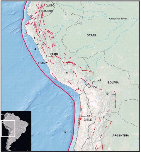
The resulting overthickening of the crust gave rise to the Cordillera Blanca uplift, which has some of the highest elevations in the Andes and where Quaternary normal faults are associated with recent surface faulting (Bonnot 1984, Bonnot et al. 1988, Schwartz 1988, Macharé et al. 2003) (Fig. 3). Also, it is important to note that shallow seismicity characterizes the Eastern Cordillera and the sub-Andean zone (Suárez et al. 1983, Dorbath et al. 1991) where active deformation is dominated by fault-related folds such as the Shitari fault system and other unnamed structures (Macharé et al. 2003).
Figure 3: Sketch of main Quaternary deformation along the Central Andes, including the Peruvian flat-slab segment (4°-14°S) and the normal subduction segment (14°-27°S). The fold and fault systems referred in the text are: 1. Shitari; 2. Chaquilbamba; 3. Quiches; 4. Cordillera Blanca; 5. Huaytapallana; 6. Cuzco; 7. Incapuquio; 8. Escoma-Achacachi-Peñas-Kenko; 9. Beni; 10. Mande-Yapecua; 11. Lomas de Olmedo; 12. Atacama; 13.Trench.
The most significant Quaternary deformation reported so far in Peru is located along this flat-slab sector where historic surface ruptures have occured along the Chaquilbamba and Quiches faults (Silgado 1951, Doser 1987, Bellier et al. 1989, 1991, Macharé et al. 2003), whereas seismicity is ongoing along the Huaytapallana fault zone (Macharé et al. 2003). There is outstanding morphogenetic expression of the Cordillera Blanca fault (Bonnot 1984, Schwartz et al. 1984, Bonnot et al. 1988, Schwartz 1988) as well as good geomorphic expression of both normal and reverse faults in southern Peru along the Cuzco and other fault systems (Sébrier et al. 1985, Macharé et al. 2003) (Fig. 3).
One of the most distinctive tectonic expressions of flat-lying subduction at the Pampean segment of the Central Andes, is the development of broken foreland uplifts between 27° S and 33° S (the Sierras Pampeanas in Argentina) (Jordan et al. 1983a,b). However, no similar features with associated Quaternary activity have been described so far in the Peruvian flat-slab.
THE NORMAL SUBDUCTION SEGMENT OF THE CENTRAL ANDES (14°S - 27°S)
This segment is underlain by normal subduction with a sharp change in subduction angle at its northern end and a smooth transition to a flat-slab sector to the south (Barazangi and Isacks 1976, Chinn and Isacks 1983). The Central Andes at these latitudes, particularly between 14°S and 20°S are the widest part of the Andean chain (as much as 600 km). From west to east, the main morphostructural Andean units in Peru, Bolivia, Chile and Argentina are composed of the Pacific Coast (which includes the offshore Perú-Chile trench, the Coastal Cordillera and the Central Valley), the Western Cordillera, the Altiplano-Puna plateau, the Eastern Cordillera and the sub- Andean zone.
Quaternary deformation is represented by high-angle normal faults in internally drained plateaus such as the Puna and Altiplano, high-angle reverse faults along the thick-skinned basement-cored uplifts of the Cordillera Oriental, and low angle thrusts and fault-related folds at the sub-Andean thin-skinned fold-and-thrust belt.
Geomorphic evidence of recent tectonic activity with different geometries and kinematics have been reported between the Coastal Cordillera and the western piedmont of the Western Cordillera, north and south of the Arica elbow in Perú and Chile (Muñoz and Charrier 1996, Jacay et al. 2002, González et al. 2003, Audin et al. 2003, this volume, Allmendinger et al. 2005).
The NNW-trending Incapuquio fault system (Jacay et al. 2002, Audin et al., this volume) located at the western piedmont of the Western Cordillera has reactivated old tectonic structures and is associated with thrust-related folds, strike-slip faults and normal faults that extend about 200 km over the Western Cordillera piedmont (Fig. 3).
The coastal ranges in Peru exhibit normal faults trending perpendicular to the coast, whereas in northern Chile reverse or normal faults trend obliquely to the coast (González et al. 2003, Allmendinger et al. 2005).
In the northern part of the Chilean Andean fore arc, the Pampa de Tamarugal represents a young tectonic depression (also known as the Northern Central Depression or Longitudinal Valley) which morphologically separates the Coastal Range from the Precordillera. Extensional tectonics does not seem to have played a role in the formation of the Central Depression (Reutter et al. 1988) in contrast to coastal marine terraces that are affected by E-W extensional deformation.
Andean subduction in Chile is characterized by a general oblique convergence vector with respect to the plate boundary. The different ways this oblique convergence is accommodated and their links with resulting Quaternary features is still not well understood (Lavenu et al. 2002). Onshore uplift is demonstrated by elevated Quaternary marine terraces suggesting Quaternary uplift rates from 0.2 to 0.6 mm.yr-1 (Ortlieb et al. 1996, Marquardt et al. 2004, 2005, Lavenu this volume). In those coastal areas (23ºS-27ºS) about 100 km to the east of the trench, the stress regime during the late Pleistocene is reflected by E-W extension on the nearly 800-km-long Atacama fault (Fig. 3). This fault probably represents the most significant geomorphic imprint of Quaternary deformation at the fore arc. Its varying kinematic signatures have inspired different interpretations including rightlateral (Saint Amand and Allen 1960, Arabasz 1968, Okada 1973, Dewey and Lamb 1992), left-lateral (Armijo and Thiele 1990), and normal faulting (Delouis et al. 1998, Lavenu et al. 2000, Lavenu this volume).
Quaternary deformation and related state of stress of the Transversal Cordillera (between 18°S and 22°S) is still poorly documented.
The uplift of the Altiplano-Puna plateau has been thermally induced (Froidevaux and Isacks 1984). It has a mean elevation of 3800 m, but lies below the Western and Eastern Cordillera. The Central Altiplano, which was the more subsiding region in the Cenozoic, is characterized by important continental sedimentation. Faults and folds resulting from Neogene compressive Andean tectonics affect this entire region (Lavenu and Mercier 1991, Mercier et al. 1992). In addition, during the Quaternary, the Altiplano has been affected by N-S extensional tectonics that can be related to the effect of high topography (Sébrier et al. 1985). A side effect of this process has been basinal collapse and associated landsliding along these and other piedmont faults (Lavenu et al. 2000). This deformation is responsible for important normal faults with a cumulative displacement of more than 400 m near the city of La Paz (Lavenu et al. 2000).
The Eastern Altiplano, which forms the western piedmont of the Eastern Cordillera, is bounded on the east by a major fault zone (Escoma, Achacachi, Peñas and Kenko fault zones in Fig. 3) that forms the escarpment of this Cordillera (Lavenu 1981, Lavenu and Mercier 1991, Lavenu et al. 2000). The tectonic basin occupied by Lake Titicaca is controlled by these normal faults and is one of the consequences of NS Quaternary extension (Lavenu 1992). Quaternary deformation affecting Quaternary bajadas and other alluvial surfaces and resulting from different stress regimes has been reported from the Altiplano south to the end of the Puna plateau (Palma and Vujovich 1987, Cortés et al. 1987, Allmendinger et al. 1989, Allmendnger and Gubbels 1996, Lavenu et al. 2000).
The Eastern Cordillera has been an area of uplift during the entire Cenozoic (Sebrier et al. 1988, Mon 1993). Neogene deformation of the Cochabamba and Tarija basins and other places in Bolivia has been reported (Lavenu et al. 2000). In Argentina, basement- related deformation gave rise to faults and folds in Neogene strata and sometimes Quaternary sediment, but without strong geomorphic evidence of Quaternary activity (Mon 1976).
The sub-Andean lowlands fold-and-thrust belt constitutes an Andean orogenic front that has been dominated by contraction since the Neogene (Baby et al. 1989, 1992, Dumont 1996). Pleistocene deposits are thrusted along the Mandeyapecuá fault (Moretti et al. 1996) (Fig. 3), and thus could confirm recent deformation along the orogenic front. In Argentina, it has been suspected that important Quaternary deformation and seismic potential must be related to thrust faults and growing anticlines (Stein and Yeats, 1989) along the sub-Andean region (here including the Sierras Subandinas and Santa Bárbara ranges). One of the most important historic Argentinean earthquakes (Talavera de Esteco, 1692) occurred in this region (Salta province); Castano and Zamarbide (1978) calculated a magnitude of 7.3 for this historic event. The forest cover has hampered recognition of all but the most prominent morphogenic Quaternary structures, although Ramos et al. (2003, this volume) reported significant evidence of this style of Quaternary deformation at the Lomas de Olmedo fault system (Fig. 3).
To the north, the Beni foreland basin is located northeast and east of the Bolivian Andean chain in front of the sub-Andean fold-and-thrust belt. As with other foreland basins, the Beni basin is a flexural basin that is presently subsiding. Dumont (1996) has suggested that the Beni River is currently being deflected northward by the northtrending Beni fault (Fig. 3).
THE PAMPEAN FLAT-SLAB (27°S-33°S)
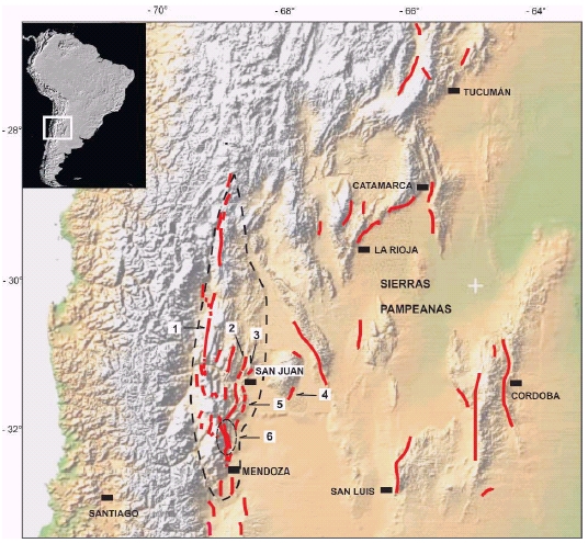
Quaternary deformation above the Pampean (Chilean) flat-slab is better exposed at the eastern Andean slope. This latitudinal section concentrates more than 90 percent of the Quaternary deformation currently documented in Argentina (Costa et al. 2000a) which is particularly prominent at its southern half (30°S-33°S). Quaternary deformation includes historic surface rupturing on La Laja fault during the 1944 Mw 7.0 San Juan (Castellanos 1944, Groeber 1944, Harrington 1944) the 1977 Mw 7.4 Caucete earthquakes on the Ampacama- Niquizanga fault (Volponi et al, 1978, Bastías 1985) (Fig. 4), as well as the more significant historical and instrumental seismic events. The reported concentration of Quaternary structures on the flat-slab subduction segment matches the observation that seismic energy released in the upper plate is on average 3 to 5 times greater than in sectors with normal subduction angles (Jordan et al. 1983a,b, Smalley et al. 1993, Gutscher et al. 2000, Ramos et al. 2002).
Figure 4: Sketch of the main Quaternary fault and fold systems developed on the Pampean flatslab. 1. El Tigre; 2. Villicum-Zonda-Pedernal; 3. La Laja-Marquezado-La Rinconada-Cerro Salinas; 4. Ampacama-Niquizanga; 5. Las Peñas-Las Higueras. Morphostructural expression of the Precordillera within dashed lines.
As a result of the eastward migration of the Andean orogenic front during the Neogene, orogenic activity during Pliocene- Pleistocene is evidenced by the rise of the Precordillera fold-and-thrust belt (Ramos 1988). The active Andean front and main Quaternary structures are currently located between its eastern foothills and the westernmost Sierras Pampeanas (Fig. 4) (Bastías et al. 1984, 1990, 1993, Cortés et al. 1999, Costa et al. 2000a, 2000b). The Quaternary structures have overprinted previous structures in both the Precordillera and Sierras Pampeanas.
The Western and Central Precordillera north of 32°S behave as a thin-skinned thrust belt with east-verging (Andean-type) thrusts. The Eastern Precordillera exhibits basement-cored, west-verging (Pampeantype) thrusts, and has been defined as a thick-skinned triangle zone by Zapata and Allmendinger (1996). If one considers mainly tectonic heritage, the styles of Quaternary deformation of the Precordillera along the Andean front and seismic belt can be divided in two sections-north and south of 32°S.
North of 32°S, evidence of Quaternary tectonics is concentrated mainly along the Pliocene-Pleistocene-uplifted Eastern Pre- Cordillera. This morphostructure exhibits a main west-bounding thrust fault (Villicum- Zonda-Pedernal thrust), although the most impressive Quaternary deformation is at the eastern backslope of this range. The deformation is represented by rectilinear and parallel fault traces that are coincident with bedding planes in pre-Quaternary rocks as backlimb tightening-type structures. This deformational pattern has been interpreted as resulting from a distributed flexural-slip faulting type, rather than the expression of primary rupture surfaces (Costa et al. 1999, Krugh and Meigs 2001, Meigs et al., this volume). The La Laja, Marquezado, La Rinconada, Los Berros and Cerro Salinas faults (Bastías et al. 1987, 1990, Martos 1987) are the most significant structures showing this style of deformation (Fig. 4).
The rectilinear trace and Holocene morphology of El Tigre strike-slip fault is clearly seen along at least 200 km of the western slope of the Precordillera fold-andthrust belt (Bastías et al. 1984, 1987, 1990, Bastías 1985, Bastías and Bastías 1987, Bastías and Uliarte 1987, Siame et al. 1997a, 1997b, 1998, 2002, 2005) (Fig. 4). As a consequence of stress partitioning at this latitude, this fault is the main Quaternary structure that releases the longitudinal (N-S) component of continental plate motion. Although this is a striking and major fault, its slip rates are likely below 1 mm.yr-1 (Siame et al. 1997).
South of 32°S at the southern Precordillera in Mendoza province, major Quaternary deformation is transferred to emerging or blind east-verging thrusts (Las Peñas and Las Higueras thrusts (Fig. 4), Cortés and Costa 1996, Cortés et al. 1999, Costa et al. 2000b, Costa et al. 2006), many of which evolved from inverted normal faults of a Triassic rift (Ramos and Kay 1991, Dellape and Hegedus, 1995). The thick-skinned triangular zone that characterizes the interaction between the Eastern and Central Precordillera (Zapata and Allmendinger 1996) seems to vanish south of Las Peñas River (32°30' S), instead blind thrusts and growing anticlines that have evolved from inverted Triassic basins are recognized both at surface and at depth to the southern end of the Precordillera (33°S) (Triep 1987, Brooks et al. 2000, Chiaramonte et al. 2000) and as far south as 34°S (Polanski 1963, Kozlowsky et al. 1993, García et al. 2005).
The striking change in style and concentration of Quaternary deformation marks the hinge area between the flat-lying and normal- subduction segments. Epicentres of historic earthquakes as well as northward deviation of the Mendoza River at 33°S (Ortiz and Salfity 1989) may suggest that ongoing deformation at this latitude has shifted eastwards to the foreland from the main outcropping thrusts and is now being expressed through a west-verging Pampean- type blind thrust in its initial stage of development and landscape imposition (Costa et al. 2006).
The Sierras Pampeanas of Argentina are generally regarded as the broken foreland adjacent to the Andean orogen and as a main morphotectonic expression of flatslab subduction (Jordan et al. 1983a,b). They may well be modern equivalents of the Laramide-age Rocky Mountain foreland uplifts in the Western United States (Jordan and Allmendinger 1986). These basement blocks have been uplifted and tilted during the past 8-5 Myr (Ramos et al. 2002) and theirs morphostructural evolution has been linked with the development of the Pampean flat-slab and with the Andean building ever since, thus involving Quaternary deformation more than 600 km away from the trench. These blocks commonly are bounded by west-verging reverse faults that dip 30°-55°E. Such marginal faults are usually located along the western hillslopes and constitute the Neogene uplifted front of the ranges. Quaternary deformation has been reported along many of them (Massabie 1987, Costa 1999, Costa et al. 2000a, and many others).
It is commonly understood that these typical intraplate faults have long recurrence intervals. However, recent studies have suggested that prehistoric earthquakes have ruptured to the surface, probably with coseismic vertical slip larger than 1m (Costa and Vita Finzi 1996, Costa et al. 2001). Thus, the seismic capability of these faults seems to be much more relevant than suggested by the seismic catalog.
THE CENTRAL ANDES SOUTH OF 33°S
South of 33°S the subudction of the Nazca plate is characterized by a normal subduction angle and a narrow Andean orogenic belt. The transition with the Quaternary deformation located north of 33°S is characterized by blind thrusting and different types Quaternary faults at the Frontal Cordillera and southernmost Precordillera foothills (Polanski 1963, Regairaz and Videla Leaniz 1968, Bastías et al. 1993, Tello 1994, Cortés and Sruoga 1998, Chiaramonte et al. 2000, Koslowsky et al. 1993, Cortés et al. 1999, Brooks et al. 2000, García et al. 2005). During the Quaternary, deformation has been partitioned into two states of stress south of 32°S (Lavenu and Cembrano 1999, Lavenu et al. 2000). In the fore-arc sliver (Costal Cordillera, Central Depression, and part of the Main Cordillera), compressive deformation along N-S trends, is recorded by reverse faults (San José de Maipo, Esperanza, and Victoria faults east from Santiago and southeast from Concepción) (Lavenu et al. 2000, 2002, this volume).
At the intra-arc, the Liquiñe-Ofqui fault system (Hervé 1976, Hervé and Thiele 1987, Cembrano et al. 1996) is at the southern Central Andes a prominent neotectonic feature that suggests Quaternary stress partitioning (Fig. 5). Trans-pressive NE-SW deformation occurred during the Pleistocene along this fault system (Lavenu and Cembrano 1999, Lavenu, this volume). Local changes from transpresive to transtensive regimes along its trace have been reported on the basis of the trend of reactivated faults (Lavenu, this volume). The northern growth of this fault system into the eastern Andean slope in Argentina has been proposed by Folguera et al. (2004), thus constituting the modern orogenic front between 36°S and 38°S (the Antiñir- Copahue fault zone of the Guañacos foldand- thrust belt) (Fig. 5).
Figure 5: Main trace of Liquiñe-Ofqui Fault Zone (LOFZ) and the Antiñir-Copahue Fault System (ACFS). Both right-lateral strike-slip systems are partitioning the deformation at these latitudes (modified from Folguera et al. 2004).
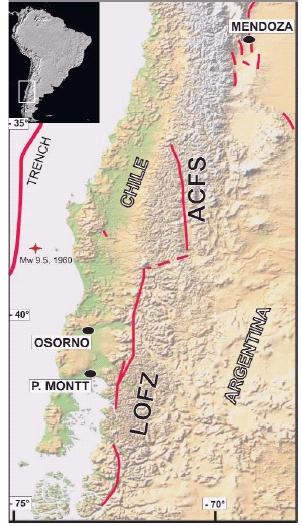
This part of the Andes generate the largest 470 instrumentally recorded earthquake in the world (the Mw 9.5, 1960 Chilean Earthquake); although with an offshore epicenter this event determined uplift and subsidence along large parts of south-central Chile (Saint-Amand 1963, Plafker and Savage 1970, Atwater et al. 1992, Cifuentes 1989, and many others). Even forty years after this event, GPS measurements indicate that the crust is still adjusting to this sudden strain release (Kendrick et al. 1999).
This and other ancient mega-thrust earthquakes have left their imprints in coastal terraces rather than as noticeable onshore ruptures. However, the role of uplifted terraces in illuminating the record of previous earthquakes has proved to be elusive. The complications related to differential preservation of evidences and temporary reversals in the sense of movement have been addressed by Atwater et al. (1992) and Vita Finzi (1996).
Rock-avalanches and landslides seem to be the remaining evidence of secondary and off-fault effects of large prehistoric earthquakes that were not necessarily associated with surface ruptures in the Andes between 36°S and 38°S (González Díaz et al. 2006, Hermanns et al. 2003, Costa and González Díaz, in press).
QUATERNARY DEFORMATION AT THE SOUTHERN ANDES (46° 30'S- 55°S)
The southern Andes extend south of the Triple Junction that links the subduction of the Chile rise with the interaction of the South America, Nazca, and Antarctica plates (Figs. 1 and 6). Little is known about the Quaternary tectonics between the Gulf of Penas (46°30' S) and the Tierra del Fuego. The rugged terrain and dense forest cover on the western slope have so far prevented paleoseismic research other than image interpretation and general reconnaissance surveys. Neogene deformation is partitioned through strike-slip structures at the forearc and a fold-and-thrust belt along the eastern foothills of continental South America, where Neogene deformation has been documented (Ramos 1989, Kraemer 1993) but no Quaternary structures have been specifically studied.
Figure 6: Location of the Jundiaí and Boa Cica faults, which affect Neogene sedimentary units; (C) epicenters that illuminate the Samambaia fault.
In the Fueguian Andes at the southern tip of South America, a striking change in the pattern of Quaternary deformation is caused by the interaction of the South American and Scotia plates, giving rise to a dominance of strike-slip faulting on Tierra del Fuego Island (Winslow 1982, Winslow and Prieto 1991, Klepeis 1994, Lodolo et al. 2003, Smalley et al. 2003). Two Ms 7.8 earthquakes that occurred on December 17th, 1949, caused surface ruptures along the Fagnano-Magallanes fault (Fig. 6), which is considered to be the onshore expression of this plate-transform boundary.
Geologic investigations (Schwartz et al. 2001, 2002, Costa et al. this volume) near Fagnano Lake have documented 1-2 m of normal coseismic slip with an undetermined (submetric) amount of left-lateral movement. The secondary strike-slip component fits the interpretation that Lago Fagnano is in a transtensive section of this major fault system (Lodolo et al. 2003).
EXTRA ANDEAN SOUTH AMERICA
Except for some areas in Brazil, Quaternary deformation along this intraplate region (which is larger than the entire Andean Cordillera) is poorly studied and not well documented. Neogene structures, particularly those with Quaternary activity or the capacity for future movement, have long recurrence intervals (5 kyr to 100 kyr or more). This is because they do not reflect direct plate interaction, but instead reflect low-strain rate reactivation of previous anisotropies and structures (sometimes very old) under the present stress regime after a long cycle of stress loading.
As demonstrated in other "stable" continental regions, surface deformation can occur at unexpected locations, even those without noticeable seismicity and/or late Quaternary faulting (Crone et al. 1997, 2003). In these regions, Quaternary rates of deformation are considerably lower (and probably well below 0.1 mm/yr) than prevailing erosion or deposition rates, thus resulting structures have only a slight chance of imposing their geomorphic signatures into the landscape assemblages as a result of faulting. Macroscale and even regionally continuous linear features in cratonic and pericratonic areas may result from the passive imposition of long-lived structures commonly enhanced by fluvial systems. Conversely, subtle linear features and anomalies in river patterns in Quaternary basins might evolve from the ongoing propagation of brittle subsurface structures with slip rates much lower than the sedimentation rate. The interpretation as to whether or not these features have Quater-nary activity is often a matter of controversy due to the lack of diagnostic data (Peulvast et al. in press) datable materials, or natural exposures.
For continental extra-Andean South America, Riccomini and Assumpção (1999) have divided it into the Brazilian and Patagonian platforms, the former being composed of Archean to Proterozoic cratons, Neoproterozoic orogenic belts, and Phanerozoic sedimentary basins. The latter includes extra- Andean Patagonia as well as the Pampean and surrounding regions cored by the Pampia craton.
In the Brazilian platform, several examples of Quaternary tectonics have been reported, particularly in the past two decades (Riccomini et al. 1989, Assumpção 1992, Saadi 1993, Bezerra et al. 1998, 2001, 2005, this volume, Saadi et al. 2002, 2005, Bezerra and Vita-Finzi 2000, and many others). These cases include not only surface ruptures but also for development of liquefaction features and geodetic anomalies.
Structures affecting Quaternary deposits often correspond to reactivated fault planes with a long history of both reactivation phases and stress regimes. The contemporary continental stresses result in E-W to WNW-ESE shortening along the Atlantic coast, although several changes in stress regimes have been documented during the Quaternary (Riccomini and Assumpção 1999, Saadi et al. 2002). Also, recent apatite fission-track dating suggests a significant rate of crustal uplift since the Miocene (Nóbrega et al. 2005).
A record of Quaternary deformation is present in several craton-related basins, such as the Amazonas, Pantanal and Paraná basins (Iriondo and Suguío 1981, Riccomini and Assumpção 1999, Saadi et al. 2002, 2005). However, the two areas where Quaternary deformation has been well documented are the Borborema region in northeastern Brazil and along the Serra do Mar rift system (Sao Paulo and Rio de Janeiro States). In the state of Rio Grande do Norte in northeastern Brazil, raised marine terraces record coastal uplift and submergence during the Quaternary. Tectonic differential coastal uplift and subsidence, in excess of that predicted by glacioisostaic models, have been suggested (Barreto et al. 2002) because part of the data can not be explained by eustatic variations alone.
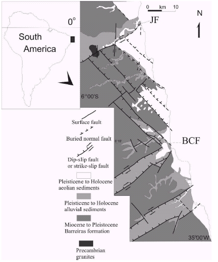
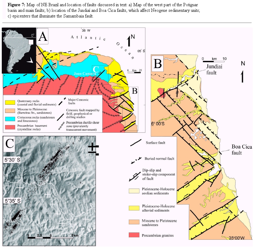
Liquefaction features in Quaternary alluvial gravel and gravelly sediment have been described at the Potiguar basin area. These features are linked to historical earthquakes as well as to paleoseismicity, accounting for paleomagnitudes of about M 6.8 (Bezerra and Vita-Finzi 2000, Bezerra et al. 2005, this volume). Among the most significant faults in terms of Quaternary deformation, the Jundiaí and Boa Cica faults (Fig. 7) record Holocene displacements, the former having a cumulated vertical slip of approximately 260 m on Miocene deposits (Barreiras Formation) (Bezerra and VitaFinzi, 2000, Bezerra et al. 2001, this volume). The trace of the NE-trending Samambaia fault (Fig. 7) shows prominent seismicity near the village of João Câmara (Takeya et al. 1989, Bezerra et al., this volume), illustrating one of the few cases where a fault is imaged by seismicity in intraplate areas.
Figure 7: Map of NE Brazil and location of faults discussed in text: a) Map of the west part of the Potiguar basin and main faults; b) location of the Jundiaí and Boa Cica faults, which affect Neogene sedimentary units; c) epicenters that illuminate the Samambaia fault.
At the Serra do Mar, several Quaternary structures have been described as affecting the Cenozoic basins related to the continental rift (Riccomini 1989, and many others cited in Riccomini and Assumpção 1999). These structures mainly represent the reactivation of previously active structures having a general NE-SW trend. They record different stress regimes acting during the Quaternary in that region. The few reports on Quaternary deformation on the Pampean plains and in extra-Andean Patagonian regions have commonly noted local features having only secondary evidence or tectonic origins (Quattrocchio et al. 1994, Sagripanti et al. 1999, Brunetto 2005, 2006, Mon et al. 2005, and Rosello et al. 2005).
CONCLUDING REMARKS
Quaternary deformation in South America is concentrated along the Andean Cordillera and adjacent regions, whereas deformation has been sparsely documented in the extra-Andean regions. The inherited structural discontinuities and ongoing plate interactions are the main controls on the distribution, geometry, and kinematics of Quaternary deformation. At both ends of continental South America, major Quaternary structures have formed principally from plate interactions with strike-slip regimes, whereas Quaternary deformation along the Central Andes (4°S-46°30'S) is basically compressional and related to subduction of the Nazca plate. The influence the style and distribution of structures with Quaternary activity is strongly influenced by the subduction angle and the resulting interaction with the overriding South American plate.
Quaternary structures along the Northern Andes are the most continuous and of continental scale. Most of these faults have slip rates higher than 1 mm.yr-1 and are commonly associated with shallow crustal seismicity. Through a complex geometric and kinematic framework, these structures accommodate and transfer ongoing stresses resulting from the interaction of the Caribbean and South America plates. These structures have strike-slip movement (i.e. Oca-Ancón, San Sebastián, Los Bajos El Soldado and Boconó fault in Venezuela, Chingual and Pallatanga faults in Ecuador), transpressive, and even compressive types of movements (the Eastern Cordillera frontal fault system in Colombia).
Along the Central Andes, the traces and distribution of structures with Quaternary activity are less continuous and less well organized. The Pacific coastal region and the western Andean piedmont are the closest areas to large offshore subduction earthquakes. However, Quaternary deformation is not represented by prominent fault zones (except for the Atacama fault in Chile), but raher through emerging or subsiding areas instead.
The style and characteristics of Quaternary tectonics at the surface are mainly the consequences of different geometries of the subducting angle of the Nazca plate. Therefore, along the Central Andes, particularly north of 33°S, the subducting plate can be grouped into different segments. At the Peruvian flat-slab segment (4°S-14°S) both normal and reverse faulting have been documented, some of them as short traces with associated historical ruptures and others as main bounding structures of high mountain ranges such as the Cordillera Blanca fault.
At the normal subduction segment of the Andes between 14°S and 27°S Quaternary faulting has been described along the Peruvian and Chilean coastal areas, where the Atacama fault system stands out. Quaternary deformation is represented across the Andes by high-angle normal faults at the Puna and Altiplano plateaus; high-angle reverse faults along the Cordillera Oriental, and thin-skinned thrusts at the sub-Andean zone.
The Pampean flat-slab segment of the Central Andes (27°S-33°S) concentrates Quaternary deformation along the orogenic front at the eastern foothills of the Precordillera. This deformation is also distributed across the Andean foreland through block uplifts of the Sierras Pampeanas where most of their bounding reverse faults have undergone activity during the Quaternary. Except for a few structures, the Quaternary deformation south of 33°S is poorly documented. In southernmost South America at Tierra del Fuego island, the Magallanes- Fagnano fault is an onshore E-W-trending transform boundary between the South America and Scotia plates. It constitutes a well expressed linear feature on a regional scale, with left-lateral motion predicted from modern plate kinematics and documented by GPS studies.
For extra-Andean South America, much progress in neotectonics has been made during the last two decades, particularly at the coastal regions in Brazil. Here, Quaternary activity has been documented on faults that have reactivated previous discontinuities or fault zones, as well as the discovery of secondary phenomena related to Quaternary faulting. Structures in these type of stable continental settings commonly have short traces compared with Andean structures and are commonly linked to Mesozoic rift zones or even older crustal weaknesses. Except for the primary Quaternary faults in the Northern Andes of Venezuela and Colombia, most Quaternary structures in continental South America are developed within an intraplate domain. Here, inherited discontinuities and their relations with the present stress regime seem to influence the time span of their seismic cycles much more than do distant interplate interactions. Due to the long recurrence intervals inherent in the seismic cycles of intraplate structures (103-105 years), they may not be imaged by seismicity, but still have proven seismogenic capability. The recent devastating earthquake in Gujaratj, India (almost 20,000 deaths), the 1812 New Madrid earthquakes in the USA, and lesser but illustrative surface-faulting earthquakes in Australia (Crone et al. 2003) show that many stable continental interior regions are not so stable. Thus, information on Quaternary faulting and surface deformation would add significant data for expanding the record of historical and instrumental seismicity and for developing more realistic assessments of the seismic capability posed by a structure. This in turn, would help to a better understanding on the likely spatial and temporal distribution of future damaging earthquakes.
ACKNOWLEDGEMENTS
We thank all the colleagues that collaborated with the ILP Project "World Map of Major Active faults". We are also indebted to V. Ramos and M. Sébrier for constructive reviews. O. Pedersen, H. Cisneros and E. Ahumada helped with the graphics.
WORKS CITED IN THE TEXT
Aggarwal, Y. 1983. Neotectonics of the Southern Caribbean: Recent Data, new ideas. Acta Científica Venezolana 34(1):17. [ Links ]
Allmendinger, R., Strecker, M., Eremchuk, J.E. and Francis, P. 1989. Neotectonic deformation of the southern Puna Plateau northwestern Argentina. Journal of South American Earth Sciences 2 (2): 111-130. [ Links ]
Allmendinger, R.W. and Gubbels, T. 1996. Pure and simple shear plateau uplift, Altiplano-Puna, Argentina and Bolivia. Tectonophysics 259: 1-13. [ Links ]
Allmendinger, R. W., Gonzalez G., Yu J., Hoke G. and Isacks B. 2005. Trench-parallel shortening in the Northern Chilean Forearc: Tectonic and climatic implications. Geological Society of America, Bulletin 117: 89-104. [ Links ]
Arabasz, W.J. 1968. Geologic structure of the Tal-tal area, northern Chile, in relation to the earthquake of December 28, 1966. Bulletin of the Seismological Society of America 58: 835-842. [ Links ]
Armijo, R., and Thiele, R. 1990. Active faulting in Northern Chile-Ramp stacking and lateral decoupling along a subduction plate boundary? Earth and Planetary Science Letters 98: 40-61. [ Links ]
Asociación Colombiana de Ingeniería Sísmica (AIS) 1996. INGEOMINAS-Uniandes, Estudio general de la amenaza sísmica en Colombia: INGEOMINAS, Bogotá, 254 p. [ Links ]
Assumpção, M., 1992. The regional intraplate stress field in South America. Journal of Geophysical Reseach 97: 11,889-11,903. [ Links ]
Atwater, B. F., Nuñez, H. J. and Vita-Finzi, C. 1992. Net Late Holocene emergence despite earthquake-induced submergence, southcentral Chile. Quaternary International 15/ 16: 77-85. [ Links ]
Aubouin, J., Audebaud, E., Debelmas, J., Dollfus, O., Dresh, J., Faucher, B., Mattauer, M., Mégard, F., Paredes, J., Savoyat, E., Thiele, R. and Vicente, J. C. 1973. De quelques problèmes géologiques et géomorphologiques de la Cordillère des Andes. Revue de Géographie Physique et de Géologie Dynamique 2-15(1- 2): 207-216. [ Links ]
Audemard, F. A. 1999. Morpho-structural expression of active thrust fault systems in the humid tropical foothills of Colombia and Venezuela. Zeitschrift für Geomorphologie 118: 1-18. [ Links ]
Audemard, F. E. and Audemard, F. A. 2002. Structure of the Mérida Andes, Venezuela: relations with the South America-Caribbean geodynamic interaction. Tectonophysics 345: 299-327. [ Links ]
Audemard, F. Machette, M., Cox, J., Dart, R. and Haller, K. 2000. Map and Database of Quaternary Faults in Venezuela and its Offshore Regions. U.S. Geological Survey Open-File Report 00-018, 82 p. [ Links ]
Audemard, F. A., Romero, G. Rendon, H. and Cano, V. 2005. Quaternary fault kinematics and stress tensors along the southern Caribbean from microtectonic data and focal mechanism solutions. Earth-Science Reviews 69 (3-4): 181-233. [ Links ]
Audemard, F., Singer, A and Soulas, J-P. 2006. Quaternary Faults and Stress Regime of Venezuela, Revista Asociación Geológica Argentina (this volume). [ Links ]
Audin, L., Hérail, G,. Riquelme, R., Darrozes, J., Martinod, J. and Font, E. 2003. Geomorphological markers of faulting and neotectonic activity along the western Andean margin, northern Chile. Journal of Quaternary Science 18(8): 681-694. [ Links ]
Audin, L., David, C., Hall, S., Farber, D. and Hérail, G. 2006. Geomorphic evidences of recent tectonic activity in the forearc, Southern Peru, Revista Asociación Geológica Argentina (this volume). [ Links ]
Baby, P., Hérail, G., López, J.M., López, O., Oller, J., Pareja, J., Sempéré, T. and Tufiño, D. 1989. Structure de la Zone subandine de Bolivie : Influence de la géométrie des séries sédimentaires antéorogéniques sur la propagation des chevauchements. Comptes Rendu Academie des Sciences, Série 2, 309: 1717-1722. [ Links ]
Baby, P., Hérail, G., Salinas, R. and Sempéré, T. 1992, Geometry and kinematic evolution of passive roof duplexes deduced from cross section balancing-Example from the foreland thrust system of the Southern Bolivian Subandean Zone: Tectonics 11(3): 23-536. [ Links ]
Barazangi, M. and Isacks, B. 1976. Spatial distribution of earthquakes and subduction of the Nazca plate beneath South America. Geology 4: 686-692. [ Links ]
Barreto, A., Bezerra, F., Suguio, K, Tatumi, S., Yee, M, Paiva, R. and Munita, C. 2002. Late Pleistocene marine terrace deposits in northeastern Brazil: sea-level change and tectonic implications. Palaeogeography, Palaeoclimatology, Palaeoecology179 (1-2): 57-69. [ Links ]
Bastías, H. 1985. Fallamiento Cuaternario en la región sismotectónica de Precordillera. PhD Thesis, Universidad Nacional de San Juan (inédita) 147 p., San Juan. [ Links ]
Bastías, H. 1990. Discontinuidades tectónicas a la latitud de 32° sur y su importancia en las hipótesis de evolución de Precordillera. 11° Congreso Geológico Argentino, Actas 2: 407-411. [ Links ]
Bastías, H. and Bastías, J. 1987. Análisis de desplazamientos y velocidades en el Area Diferencial Precordillera. Revista Asociación Geológica Argentina 42: 261-266. [ Links ]
Bastías, H. and Uliarte, E. 1987. Morfología de la falla rumbo-deslizante El Tigre entre los ríos Jachal y San Juan. 10° Congreso Geológico Argentino, Actas 1: 251-254. [ Links ]
Bastías, H., Weidmann, N. and Pérez, M. 1984. Dos zonas de fallamiento Pliocuaternario en la Precordillera de San Juan. 9° Congreso Geológico Argentino, Actas 2: 329-341. [ Links ]
Bastias, H., Uliarte, E., Paredes, J., Sanchez, A., Bastias, J., Ruzicki, L. and Perucca, L. 1990. Neotectónica de la provincia de San Juan. 11° Congreso Geologico Argentino, Relatorio: 228-244. [ Links ]
Bastias, H., Tello, G., Perucca, L., and Paredes, J. 1993, Peligro sísmico y neotectónica, En Ramos V. (ed.) Geología de la provincia de Mendoza. 12° Congreso Geológico Argentino, Relatorio: 645-658. [ Links ]
Bellier, O., Macharé, J. and Sébrier, M. 1989. Extensión Actual Del Nor Perú: Estudio de la Falla Activa de Chaquilbamba (Norte del Departamento de la Libertad, Perú. Boletín Sociedad Geológica Perú 80:1-12. [ Links ]
Bellier, O., Dumont, J.-F., Sébrier, M. and Mercier, J.-L. 1991. Geological constraints on the kinematics and fault-plane solutions of the Quiches fault zone reactivated during the 10 November 1946 Ancash earthquake, northern Peru. Bulletin Seismological Association of America 81(2): 468-490. [ Links ]
Beltrán, C. and Giraldo, C. 1989. Aspectos neotectónicos de la región nororiental de Venezuela. 7° Congreso Geológico Venezolano, Proceedings 3: 1000-1021. [ Links ]
Bevis, M., Kendrick, E. Smalley Jr., R. Brooks, B. A. Allmendinger, R.W. and Isacks, B.L. 2001. An overview of the main quaternary deformation of South America on the strength of interplate coupling and the rate of back arc convergence in the central Andes: An analysis of the interseismic velocity field. Geochemestry, Geophysics, Geosystems 2, 10.129/2001GC000198. [ Links ]
Bezerra, F.H.R. and Vita-Finzi, C. 2000. How active is a passive margin? Paleo-seismicity in northeastern Brazil. Geology 28: 591-594. [ Links ]
Bezerra, F.H.R., Lima-Filho, F.P., Amaral, R.F., Caldas, L.H.O. and Costa-Neto, L.X. 1998. Holocene Coastal tectonics in NE Brazil. In: Stewart, I. and Vita-Finzi, C. (eds.): Coastal Tectonics. Geological Society of London, Special Publication 146: 279-293. [ Links ]
Bezerra, F.H.R., Amaro, V.E., Vita-Finzi, C. and Saadi, A. 2001. Pliocene-Quaternary fault control of sedimentation and coastal plain morphology in NE Brazil. Journal of South American Earth Sciences 14: 61-75. [ Links ]
Bezerra, F.H.R., Amaral, R.F., Vita-Finzi, C., Lima-Filho, F.P. and Saadi, A. 2005. Liquefaction-induced structures in Quaternary alluvial gravels and gravelly sediments, NE Brazil. Engineering Geology 76: 191-208. [ Links ]
Bezerra, F. H., Ferreira, J. and Souza, M., 2006. Review of seismicity and Neogene tectonics in northeastern Brazil. Revista Asociación Geológica Argentina (this volume). [ Links ]
Bonnot, D. 1984. Néotectonique et Tectonique Active de la Cordillére Blanche et du Callejón de Huaylas, Andes Nord Peruviennes, PhD Thesis Université d'Orsay, París. [ Links ]
Bonnot, D., Sébrier, M. and Mercier, J-L. 1988. Evolution geodynamique plio-quaternaire du basin intracordillerain du Callejón de Huaylas et de la region de la Cordillére Blanche, Andes Nord Peruviennes. Geodynamique 3: 57-83. [ Links ]
Brooks, B. A., Sandvol, E. and Ross, A. 2000. Fold style inversion: Placing probabilistic constraints on the predicted shape of blind thrust faults. Journal of Geophysical Research 105: 13,281-13,302. [ Links ]
Brooks, B.A., Bevis, M., Smalley, R.Jr., Kendrick, E., Manceda, R., Lauría, E., Maturana, R. and Araujo, M. 2003. Crustal motion in the southern Andes (26°-36°S): do the Andes behave like a microplate? Geochemestry, Geophysics, Geosystems 4: 1-14. [ Links ]
Brunetto, E. 2005. Mapa de Lineamientos Morfológicos de la cuenca inferior del Río Dulce, Laguna Mar Chiquita y Bloque San Guillermo. 16° Congreso Geológico Argentino, Actas 4: 545-552, La Plata. [ Links ]
Cabrera, J, Sébrier, M. and Mercier, J-L. 1987. Active normal faulting in high plateaus of central Andes: the Cuzco region (Peru). Annales Tectonicae 1-2: 116-138. [ Links ]
Campbell, C.J. 1974. Ecuadorian Andes in Mesozoic- Cenozoic orogenic belt, data for orogenic studies. Geological Society of London Special Publication 4: 725-732. [ Links ]
Case, J. E., Duran, L. G., Lopez, A. and Moore, W. R. 1971. Tectonic investigations in Western Colombia and Eastern Panama. Geological Society of America Bulletin 82: 2685-2712. [ Links ]
Castano, J., and Zamarbide, J. 1978. Determinación de coeficientes sísmicos zonales para la República Argentina. Publicación Técnica 6, INPRES, 23 p., San Juan. [ Links ]
Castellanos, A. 1944. El terremoto de San Juan. En Cuatro lecciones sobre terremotos, Asociación Cultural de Conferencias de Rosario, p. 79-242, Rosario. [ Links ]
Cembrano, J., Hervé, F. and Lavenu, A. 1996. The Liquiñe Ofqui fault zone: a long-lived intra-arc fault system in southern Chile. Tectonophysics 259: 55-66. [ Links ]
Chiaramonte, L., Ramos, V., and Araujo, M. 2000. Estructura y sismotectónica del anticlinal Barrancas, cuenca Cuyana, provincia de Mendoza. Revista Asociación Geológica Argentina 55: 309-336. [ Links ]
Chinn, D.S., and Isacks, B.L. 1983. Accurate source depths and focal mechanisms of shallow earthquakes in western South America and in the News Hebrides islands arc. Tectonics 2: 529-563. [ Links ]
Cifuentes, I. 1989. The 1960 Chilean earthquake. Journal of Geophysical Research 94(B1): 665-680. [ Links ]
Cortés, J., and Costa, C. 1996. Tectónica Cuaternaria en la desembocadura del Río de las Peñas, Borde oriental de la Precordillera de Mendoza. 13° Congreso Geológico Argentino, Actas 2: 225-238. [ Links ]
Cortés, J., and Sruoga, P. 1998. Zonas de fractura cuaternarias y volcanismo asociado en el piedemonte de la Cordillera Frontal (34°30' LS), Argentina. 10° Congreso Latinoamericano de Geología, Actas 2:116-121. [ Links ]
Cortés, J., Franchi, M., and Nullo, F. 1987. Evidencias de neotectónica en las sierras de Aguilar y del Tanque, Cordillera Oriental y Puna Jujeñas, Argentina, 10° Congreso Geologico Argentino, Actas 1: 239-242. [ Links ]
Cortés, J., Vinciguerra, P., Yamín, M. and Pasini, M., 1999. Tectónica Cuaternaria en la región andina del nuevo Cuyo. En. R. Caminos (Ed.). Geología Argentina. SEGEMAR Anales 29: 760-778. [ Links ]
Costa, C. 1999. Tectónica Cuaternaria en las Sierras Pampeanas. En Caminos, R. (ed.) Geología Argentina, SEGEMAR, Anales 29: 779-784. [ Links ]
Costa, C. 2004. Microtectónica en el Cuaternario? Métodos y aplicaciones de la Paleosismología. Revista Asociación Geológica Argentina, Publicación Especial 7: 9-19. [ Links ]
Costa, C. and Vita-Finzi, C. 1996. Late Holocene intraplate faulting in the SE Sierras Pampeanas, Argentina. Geology 24: 1127-1130. [ Links ]
Costa, C. and González Díaz, E.F. 2006. Age constrains and paleoseismic implication of rock-avalanches in the Northern Patagonian Andes, Argentina. Journal of South American Earth Sciences, in press. [ Links ]
Costa, C., Rockwell, T., Paredes, J. and Gardini, C. 1999. Quaternary deformations and seismic hazard at the Andean orogenic front (31º-33º, Argentina): A paleoseismological perspective. 4º International Symposium on Andean Geodynamics, Proceedings: 187-191. [ Links ]
Costa, C., Machette, M., Dart, R., Bastías, H., Paredes, J., Perucca, L., Tello, G. and Haller, K. 2000a. Map and Database of Quaternary Faults and Folds in Argentina. U. S. Geological Survey Open-File Report 00-0108, 75 p. [ Links ]
Costa, C., Gardini, C. Diederix, H, and Cortés, J. 2000b. The Andean thrust front at Sierra de Las Peñas, Mendoza, Argentina. Journal of South American Earth Sciences, 13: 287-292. [ Links ]
Costa, C., Murillo, V., Sagripanti, G. and Gardini, C. 2001. Quaternary intraplate deformation in the southeastern Sierras Pampeanas, Argentina. Journal of Seismology 5: 399-409. [ Links ]
Costa, C., Cisneros, H., Machette, M. and Dart, R. 2003. A new database of Quaternary faults and folds in South America. ILP Task Group II-2 (western Hemisphere). American Geophysical Union, Fall Meeting, San Francisco. [ Links ]
Costa, C., Gardini, C., Diederix, H., Cisneros, H. and Ahumada, E. 2006. The active Andean orogenic front at the Souhternmost Pampean flat-slab. Backbone of the Americas. Abstract with Programs 15-1. [ Links ]
Costa, C., Smalley Jr, R., Schwartz, D., Stenner, H., Ellis, M. and Velasco, S. 2006. Paleoseismic observations on an onshore transform boundary: The Magallanes-Fagnano fault, Tierra del Fuego, Argentina. Revista Asociación Geológica Argentina (this volume). [ Links ]
Crone, A.J., Machette, M.N. and Bowmam, J.R. 1997. Episodic nature of earthquake activity in stable continental regions revealed by palaeosiesmicity studies of Australia and North America Quaternary fault. Australian Journal of Earth Sciences 44: 203-214. [ Links ]
Crone, A. J., De Martini, P.M., Machette, M.N., and Okumura, K. 2003. Paleoseismicity of aseismic Quaternary faults in Australia- Implications for fault behavior in stable continental regions. Bulletin of the Seismological Society of America 93(5): 1913-1934. [ Links ]
Dellapé, D., and Hegedus, A. 1995, Structural inversion and oil occurrence in the Cuyo basin of Argentina. In Tankard, A., Suárez R., and Welsink, H. (eds.) Petroleoum basins of South America, American Association of Petroleum Geologists, Memoir 62: 359-367. [ Links ]
Delouis B., Philip H., Dorbath L., and Cisternas A. 1998. Recent crustal deformation in the Antofagasta region (Northern Chile) and the subduction process. Geophysical Journal International 132: 302-338. [ Links ]
Dewey, J., and Lamb, S. 1992. Active tectonics of the Andes. Tectonophysics 205: 79-95. [ Links ]
Dorbath, L., Dorbath, C., Jiménez, E. and Rivera, L. 1991. Seismicity and tectonic deformation in the eastern Cordillera and Sub Andean zone of Central Perú. Journal of South American Earth Sciences 4: 13-24. [ Links ]
Doser, D.I. 1987 The Ancash Peru earthquake of November 19, 1946-Evidence for low-angle normal faulting in the high Andes of northern Peru. Journal of Geophysical Research 91: 57-71. [ Links ]
Dumont, J.F. 1996. Neotectonics of the Subandes-Brazilian craton boundary using geomorphological data-The Marañon and Beni basins. Tectonophysics 257: 137-151. [ Links ]
Duncan, R.A. and Hargraves, R.B. 1984. Plate tectonic evolution of the Caribbean regions in the mantle reference frame. In Bonnini, R.B., Hardgraves, R.B. and Shagan, R. (eds.) The Caribbean-SouthAmerican plate boundary and regional tectonics, Geological Society of America, Memoir 162: 81-84. [ Links ]
Duque-Caro, H. 1980. Geotectónica y evolución de la región noroccidental de Colombia. Boletin Geológico INGEOMINAS 23(3): 4-37. [ Links ]
Ego F. and Sébrier M. 1996. The Ecuadorian inter-Andean valley; a major and complex restraining bend and compressive graben since late Miocene time. Annales Tectonicae 10 (1-2): 31-59. [ Links ]
Ego F., Sébrier M., Carey-Gailhardis E. and Beate B. 1996. Do the Billecocha normal faults (Ecuador) reveal extension due to lithospheric body forces in the Northern Andes? Tectonophysics 265 (3-4): 255-273. [ Links ]
Ego F., Sébrier M. and Yepes H. 1995. Is the Cauca-Patia and Romeral fault system left - or right-lateral? Geophysical Research Letters 22. [ Links ]
Egüez, A., Alvarado, A., Yepes, H. Machette, M., Costa, C. and Dart, R. 2003. Database and Map of Quaternary Faults and Folds in Ecuador and its Offshore Region. U.S. Geological Survey Open-File Report 03-289, 77 p. [ Links ]
Fairbridge, R. 1981. The concept of neotectonics: An introduction. Zeitschrift Geomorphologischen Beilband 40: 7-12. [ Links ]
Folguera, A., Ramos, V, Hermanns, R. and Naranjo, J. 2004. Neotectonics in the foothills of the sothernmost central Andes (37°- 38°S): Evidence of strike-slip displacement along the Antiñir-Copahue fault zone. Tectonics 23, TC 5008, 23. [ Links ]
Freymueller, J.T., Kellogg, J.N. and Vega, V. 1993. Plate motions in the north Andean region. Journal of Geophysical Research 98: 21853- 21863. [ Links ]
Froidevaux, C., and Isacks, B. 1984. The mechanical state of the lithosphere in the Altiplano-Puna segment of the Andes. Earth and Planetary Science Letters 71: 305-314. [ Links ]
Gansser, A. 1973. Facts and theories on the Andes. Journal of the Geological Society of London 129 (1): 93-131. [ Links ]
García, V.H., Cristallini, E.O., Cortés, J.M., and Rodriguez, C. 2005. Structure and neitectonics of the Jaboncillo and Del Peral anticlines: New evidences of Pleistocene to ¿Holocene deformation in the Andean Piedmont. 6° International Symposium on Andean Geodynamics, Extended Abstracts: 301-304, Barcelona. [ Links ]
González, G., Cembrano, J., Carrizo, D., Macci, A. and Schneider, H. 2003. The link between forearc tectonics and Pliocene-Quaternary deformation of the Coastal Cordillera, northern Chile. Journal of South American Earth Sciences 16: 321-342. [ Links ]
González Diaz, E., Folguera, A., Costa, C., Wright, E. and Ellisondo, M. 2006. Los grandes deslizamientos de la region septentrional neuquina entre los 36°-38°S: una propuesta de su inducción por un mecanismo sísmico. Revista de la Asociación Geológica Argentina 61(2): 197-217. [ Links ]
González Ferrán, O. 1985 Mapa Neotectónico preliminar para América del Sur. SISRA Project vol. 11 Series with Map, 110 p. [ Links ]
Groeber, P. 1944. Movimientos tectónicos contemporáneos. Universidad Nacional de La Plata, Notas del Museo de La Plata, Geología 9: 263-375. [ Links ]
Gutscher, M.A., Malavieille, J., Lallemand, S., and Collot, J.Y. 1999. Tectonic segmentations of the North Andean margin-An impact of the Carnegie Ridge collision. Earth and Planetary Science Letters 168: 255-270. [ Links ]
Gutscher, M.-A., Spakman, W., Bijwaard, H. and Engdahl, E. R. 2000. Geodynamics of flat subduction; seismicity and tomographic constraints from the Andean margin. Tectonics 19(5): 814-833. [ Links ]
Hancock, P. 1988. Neotectonics. Geology Today 4: 57-61. [ Links ]
Harrington, H. 1944. Volcanes y terremotos. Ed. Pleamar, 251 p. [ Links ]
Hermanns, R.L., González Díaz, E.F., Folguera, A. and Mardones, M. 2003. Large massive rock slope failures dams, related valley evolution and their association with the tectonic setting in the Argentine and Chilean Andes between 36° and 38°S. 10° Congreso Geológico Chileno (Concepción), CD: 1-5. [ Links ]
Hervé, M. 1976. Estudio geológico de la Falla Liquiñe-Reloncavi en el area de Liquiñe; antecedentes de un movimiento transcurrente (Provincia de Valdivia). 1° Congreso Geológico Chileno, B39-B56. [ Links ]
Hervé, F. and Thiele, R. 1987. Estado de conocimiento de las megafallas en Chile y su significado tectónico. Comunicaciones 38: 7-91. [ Links ]
Hess, H. and Maxwell, J. 1953. Caribbean Research Project. Bulletin of the Geological Society of America 64 (1): 1-6. [ Links ]
Hutchings, L., Turcotte, T. and McBride, J. 1981. Microseismicity along the Dolores shear zone in Antioquia, Colombia. Seismological Society of America, 76th annual meeting, Earthquake Notes 52(1): 68-69. [ Links ]
Iglesias R., Eguez A. and Pérez V.H. 1991. Mapa Sismotectónico del Ecuador: Quito, Ecuador, Dirección Nacional de Defensa Civil, Memoria técnica 177 p. [ Links ]
Iriondo, M.H., and Suguio, K. 1981, Neotectonics of the Amazon Plain: Bulletin of INQUA, Neotectonic Commission 4: 72-78. [ Links ]
Jacay, J., Semperé, T., Husson, L. and Pino, A. 2002. Structural characteristics of the Incapuquio Fault System, southern Peru. Extended Abstract, 5° International Symposium on Andean Geodynamics: 319-321. [ Links ]
Jordan, T.H. 1975. The present-day motions of the Caribbean Plate. Journal of Geophysical Research 80: 4433-4449. [ Links ]
Jordan, T., Isacks, B., Allmendinger, R., Brewer, J., Ramos, V., and Ando, C. 1983a. Andean tectonics related to geometry of subducted Nazca plate. Geological Society of America Bulletin 94: 341 361. [ Links ]
Jordan, T.E., Isacks, B., Ramos, V.A. and Allmendinger, R.W. 1983b. Mountain building in the Central Andes. Episodes 1983(3): 20 26, Ottawa. [ Links ]
Jordan, T., and Allmendinger, R. 1986. The Sierras Pampeanas of Argentina-A modern analogue of Rocky Mountains foreland deformation. American Journal of Science 286: 737-764. [ Links ]
Kellogg, J., Godley, V., Ropain, C., and Bermúdez, A. 1983. Gravity anomalies and tectonic evolution of northwestern South America. 10th Caribbean Geological Conference, Memoir: 18-31. [ Links ]
Kellogg, J. and Vega, V. 1995. Tectonic development of Panama, Costa Rica, and the Colombian Andes: Constraints from Global Positioning System geodetic studies and gravity. Special Paper Geological Society of America 295: 75-90. [ Links ]
Kendrick, E., Bevis, M., Smalley, R.F. Jr., Cifuentes, O. and Galbán, F. 1999. Current rates of convergence across the Central Andes; estimates from continuous GPS observations. Geophysical Research Letters 26(5): 541-544. [ Links ]
Kendrick, E., Bevis, M., Smalley Jr., R. and Brooks, B. 2001. An integrated crustal velocity field for the central Andes. Geochemistry Geophysics Geosystems 2, 10.1029/ 2001GC000191. [ Links ]
Klepeis, K.A. 1994. The Magallanes and Deseado fault zones: Major segments of the South American-Scotia transform plate boundary in southernmost South America, Tierra del Fuego. Journal of Geophysical Research 99:22,001-22,014. [ Links ]
Kozlowski, E., Manceda, R. and Ramos, V. 1993. Estructura. In Ramos, V. (ed.) Geología y Recursos Naturales de Mendoza, 12° Congreso Geológico Argentino, Relatorio: 235-256. [ Links ]
Kraemer, P.E. 1993. Perfil estructural de la Cordillera Patagónica Austral a los 50° LS, Santa Cruz. 12° Congreso Geológico Argentino and 2° Congreso Exploración de Hidrocarburos, Actas 3: 119-125, Buenos Aires. [ Links ]
Krugh, W.C., and Meigs, A. 2001. Secondary deformation associated with active basement- involved folding; Late Quaternary flexural- slip faulting and kink-band migration, Sierra de Villicum, San Juan, Argentina. Geological Society of America Abstracts with Programs 33: 393. [ Links ]
Lavenu, A. 1981. Origine et évolution néotectonique du lac Titicaca. Revue Hydrobiologie Tropicale 14(4): 289-297. [ Links ]
Lavenu, A. 1986. Etude tectonique et néotectonique de l'Altiplano et de la Cordillère orientale des Andes boliviennes. ORSTOM, Travaux et Documents microfichés, 28, 420 p., Paris. [ Links ]
Lavenu, A. 1992. Formation and geological evolution. In Dejoux C. and Iltis A. (eds.) Lake Titicaca, Kluwer Academic Publisher: 1-13. [ Links ]
Lavenu, A. 2006. Neotectónica de los Andes entre 1°N y 47°S (Ecuador, Bolivia y Chile): una revisión. Revista Asociación Geológica Argentina 61(4), Buenos Aires. [ Links ]
Lavenu, A. and Mercier, J.L. 1991. Evolution du régime tectonique de l'Altiplano et de la Cordillère Orientale des Andes de Bolivie du Miocène supérieur à l'Actuel. Géodynamique 6(1): 21-55. [ Links ]
Lavenu, A. and Cembrano, J. 1999 Estados de esfuerzo compresivo plioceno y compresivotranspresivo pleistoceno, Andes del sur, Chile (38- y 42°30' S). Revista Geológica de Chile 26(1): 67-87. [ Links ]
Lavenu, A., Winter, T. and Dávila, F. 1995. A Pliocene-Quaternary compressional basin in the Interandean Depression. Central Ecuador. Geophysical Journal International 121: 279-300. [ Links ]
Lavenu, A., Thiele, R., Machette, M., Dart, R., Bradley, L. and Haller, K. 2000. Maps and Database of Quaternary Faults in Bolivia and Chile, U.S. Geological Survey Open-File Report 00-283, 50 p. [ Links ]
Lavenu, A., Cembrano, J. and Costa, C. 2002. Margin-parallel v/s margin-orthogonal compresión along a convergent margin: The Andes of Central-Southern Chile and Western Argentina. 5º International Symposium on Andean Geodynamics, Proceedings: 367-370. [ Links ]
Lodolo, E., Menichetti, M., Bartole, R., Ben- Avraham, Z., Tassone, A., Lippai, H. 2003. Magallanes-Fagnano continental transform fault (Tierra del Fuego, southernmost South America). Tectonics 22(6): 15.1-26. [ Links ]
Lonsdale, P. and Klitford, K.D. 1978. Structure and tectonic history of the eastern Panama Basin. Geological Society of America Bulletin 89: 981-999. [ Links ]
Macharé, J. and Ortlieb, L. 1992. Plio-Quaternary vertical motions and the subductión of the Nazca Ridge, central coast of Peru. Tectonophysics 205: 97-108. [ Links ]
Macharé, J., Fenton, C., Machette, M. Lavenu. A., Costa, C. and Dart, R. 2003. Database and Map of Quaternary Faults and Folds in Perú and its Offshore Region. U.S. Geological Survey Open-File Report 03-451, 55 p. [ Links ]
Machette, M. 2000. Active, Capable and Potentially Active Faults- A paleoseismic perspective. Journal of Geodynamics 29: 387-392. [ Links ]
Marquardt, C., Lavenu, A., Ortlieb, L., Godoy, E., and Comte, D. 2004. Coastal Neotectonics in Southern Central Andes: Uplift and deformation of marine terraces in Northern Chile (27ºS). Tectonophysics 394(3-4): 193- 219. [ Links ]
Marquardt, C., Fornari, M., Lavenu, A., Vargas, G., Ortlieb, L., Ritz, J. F., Philip, H. and Marinovic, N. 2005. Volcanic ash dating from the Mejillones Peninsula (23°S). Implications for the Neogene outer fore-arc stratigraphy, tectonics and volcanic relationships. 6° International Symposium on Andean Geodynamics, Proceedings: 477-480. [ Links ]
Martos, L. 1987. Evidencias de movimientos neotectónicos en una terraza de edad Holocena, La Rinconada, San Juan. 10° Congreso Geológico Argentino, Actas 1: 263- 265. [ Links ]
Massabie, A. 1987. Neotectónica y sismicidad en la región de Sierras Pampeanas Orientales, sierras de Córdoba, Argentina. 10° Congreso Geológico Argentino, Actas 1:271-274. [ Links ]
McCourt, W.J., Aspden, J.A. and Brook, M. 1984. New geological and geochronological data from the Colombian Andes; continental growth by multiple accretion. Journal of the Geological Society of London 141(5): 831- 845. [ Links ]
Meigs, A., Krugh, W., Schiffman, C., Vergés, J. and Ramos, V. 2006. Refolding of thin-skinned thrust sheets by active basement-involved thrust faults in the eastern Precordillera of western Argentina. Revista Asociación Geológica Argentina (this volume). [ Links ]
Mercier, J. 1976. La néotectonique: Ses méthodes et ses buts. Revue Geographie Physique et Geologie Dynámique 18(2):323-346. [ Links ]
Mercier, J.L., Sébrier, M., Lavenu, A., Cabrera J., Bellier, O., Dumont, J.F., and Macharé, J. 1992. Changes in the tectonic regime above a subduction zone of Andean type-The Andes of Peru and Bolivia during the Pliocene- Pleistocene. Journal of Geophysical Research 97 (B8): 11,945-11,982. [ Links ]
Mon, R. 1976. La tectónica del borde oriental de los Andes en las Provincias de Salta, Tucumán y Catamarca, República Argentina. Revista de la Asociación Geológica Argentina 31: 65-72. [ Links ]
Mon, R. and Gutierrez, A. 2005. The neotectonic origin of the natural dam of Mar Chiquita, Córdoba, Argentina. ICSU Dark Nature-IGCP 490 Joint Meeting, Abstracts and Field Guide, 33 p. [ Links ]
Moretti, I., Baby, P., Mendez, E., and Zubieta, D. 1996. Hydrocarbon generation in relation to thrusting in the Sub Andean Zone from 18 to 22°S - Bolivia. Petroleum Geoscience 2: 17-28. [ Links ]
Mörner, N. 1994. Neotectonics in new perspectives. Bulletin INQUA Neotectonics Commission 18: 63-65. [ Links ]
Muñoz, N. and Charrier, R. 1996. Uplift of the western border of the Altiplano on a westvergent thrust system, northern Chile. Journal of South American Earth Sciences 9 (3/4): 171-181. [ Links ]
Nóbrega, M.A., Sá, J.M., Bezerra, F.H.R., Hadler Neto, J.C., Lunes, P.J., Oliveira, S.G., Saenz, C.A.T. and Lima Filho, F.P. 2006. The use of apatite fission track thermochronology to constrain fault movements and sedimentary basin evolution in northeastern Brazil. Radiation Measurements, in press, Amsterdam. [ Links ]
Norabuena, E., Leffler, G.L., Mao, A., Dixon, T., Stein, S., Sacks, I., and Ellis, M. 1998. Space geodetic observations of Nazca-South America convergence across the Central Andes. Science 279(5349): 358-362. [ Links ]
Okada, A. 1971. On the neotectonics of the Atacama fault zone region. Preliminary notes on late Cenozoic faulting and geomorphic developement of Coast Range of northern Chile. Bulletin of the Department of Geography, Kyoto University 3: 47-65. [ Links ]
Ortiz, A. and Zambrano, J. 1989. Estructuración geológica profunda y expresión superficial: Ejemplos argentinos. 1° Congreso Nacional de Exploración de Hidrocarburos, Actas 2: 885-899. [ Links ]
Ortlieb, L., Zazo, C., Goy, J., Dabrio, C. and Macharé, J. 1996. Pampa del Palo: an anomalous composite marine terrace on the uprising coast of southern Peru. Journal South American Earth Sciences 9(5-6): 367-379. [ Links ]
Palma, M. and Vujovich, G. 1987, Evidencias neotectónicas en el borde oriental de la Sierra de Calalaste, Puna Catamarqueña. 10° Congreso Geológico Argentino, Actas 1: 243-249. [ Links ]
Paris, G. and Sarria, A. 1986. Proyecto geofísico del nordeste Colombiano. Informe INGEOMINAS- ISA, 59 p., Bogotá. [ Links ]
Paris, G., and Romero, R. 1994. Fallas Activas en Colombia. INGEOMINAS, Boletín Geológico INGEOMINAS 34(2-3): 3-26, Bogotá. [ Links ]
Paris, G., Machette, M., Dart, R., and Haller, K. 2000. Map and Database of Quaternary Faults and Folds in Colombia and its offshore Regions U.S.Geological Survey Open-File Report 00-284, 66 p. [ Links ]
Pavlides, S. 1989. Looking for a definition of Neotectonics. Terra Nova 1: 233-235. [ Links ]
Pennington, W.D. 1981. Subduction of the eastern Panama basin and seismotectonics of northwestern South America. Journal of Geophysical Research 86: 10,753-10,770. [ Links ]
Pérez, O. and Aggarwal, Y. 1981. Present-day tectonics of southeastern Caribbean and northeastern Venezuela. Journal of Geophysical Research 86:10,791-10,805. [ Links ]
Pérez, O., Bilham, R., Bendick, R., Hernández, N., Hoyer, M., Velandia, J., Moncayo, C. and Kozuch, M. 2001. Velocidad relativa entre las placas del Caribe y Sudamérica a partir de observaciones dentro del sistema de posicionamiento global (GPS) en el norte de Venezuela. Interciencia 26(2): 69-74. [ Links ]
Peulvast, J.P., Claudino Sales, V., Bezerra, H., and Betard, F. 2006. Landforms and neotectonics on a passive margin: the equatorial side of northeastern Brazil. Geodinamica Acta, in press. [ Links ]
Plafker, G. and Savage, J.C. 1970. Mechanism of the Chilean earthquakes of May 21 and 22, 1960: Geological Society of America Bulletin 81: 1001-1030. [ Links ]
Polanski, J. 1963. Estratigrafia, neotectónica y geomorfología del Pleistoceno pedemontano entre los Ríos Diamante y Mendoza. Revista de la Asociación Geológica Argentina 17: 127-349. [ Links ]
Quattrocchio, M., Kostadinoff, J., Martinez, G., and Prieto, A. 1994. Evidencias de neotectónica en el Río Sauce Chico, Provincia de Buenos Aires. Revista de la Asociacion Geológica Argentina 49: 297-305. [ Links ]
Ramos, V. 1988. The tectonics of the Central Andes; 30° to 33°S latitude. In Clark, S. and Burchfiel, C. (eds.) Processes in Continental Lithospheric Deformation, Geological Society of America, Special Paper 218: 31-54. [ Links ]
Ramos, V.A. 1989. Foothills structure in Northern Magallanes Basin, Argentina. American Association Petroleum Geologists 73(7): 887-903. [ Links ]
Ramos, V.A. 1999. Plate tectonic setting of the Andean Cordillera. Episodes 22: 183-190. [ Links ]
Ramos, V.A. and Kay, S. 1991. Triassic rifting and associated basalts in the Cuyo basin, Central Argentina, in R. Harmon and C. Rapela (eds.), Andean magmatism and its Tectonic Setting. Geological Society of America, Special Paper 265: 79-91. [ Links ]
Ramos, V.A., Cristallini, E.O. and Pérez, D.J. 2002. The Pampean flat-slab of the Central Andes. Journal of South American Earth Sciences 15: 59-78. [ Links ]
Ramos, V.A., Alonso, R. and Strecker, M. 2003. Neotectónica cuaternaria en Lomas de Olmedo, provincia de Salta - Argentina. 10° Congreso Geológico Chileno, Actas electrónicas (11 p. [ Links ]).
Ramos, V., Alonso, R. and Strecker, M. 2006. Estructura y Neotectónica de las Lomas de Olmedo, zona de transición entre los sistemas Subandino y de Santa Bárbara, provincia de Salta. Revista Asociación Geológica Argentina (this volume). [ Links ]
Regairaz, A., and Videla Leaniz, J. 1968. Fenómenos de la neotectónica y su influencia sobre la morfología actual del piedemonte mendocino. 3° Jornadas Geológicas Argentinas, Actas 2: 21-34. [ Links ]
Reutter, K.J., Giese P., Gotze H.J., Scheuber, E., Schwab, K., Schwarz G., and Wigger, P. 1988. Structures and crustal development of the Central Andes between 21° and 25° S. In Bahlburg, H., Breitkreuz, Ch., and Giese, P. (eds.) The Southern Central Andes. Springer Verlag, Lecture notes in Earth Sciences: 231- 261, Berlin. [ Links ]
Riccomini, C. and Assumpção, M. 1999. Quaternary tectonics in Brazil. Episodes 22(3): An overview of the main quaternary deformation of South America 478 221-225. [ Links ]
Riccomini, C., Peloggia, A., Saloni, J., Kohnke, M., and Figueira, R. 1989. Neotectonic activity in the Serra do Mar Rift system (SE Brazil). Journal of South American Earth Sciences 2(2): 191-192. [ Links ]
Robertson, K. 1989. Actividad neotectónica en el piedemonte de la Cordillera Oriental, sector Villavicencio-Tauramena, Colombia. 5° Congreso Colombiano de Geología, Memorias 1: 171-192. [ Links ]
Rossello, E.A. and Bordarampé, C.P. 2005. Las lomadas de Otumpa:Nuevas evidencias cartográficas de deformación neotectónica en el Gran Chaco (Santiago del Estero, Argentina). 16° Congreso Geológico Argentino, Actas 4: 479-484. [ Links ]
Saadi, A. 1993. Neotectônica da Plataforma Brasileira: esboço e interpretação preliminares. Geonomos 1(1): 1-15. [ Links ]
Saadi, A., Machette, M.N., Haller, K.M., Dart, R.L., Bradley, L.-A., de Souza, A.M. 2002. Map and Database of Quaternary Faults and Lineaments in Brazil: U.S. Geological Survey Open-File Report 02-230, 58 p. [ Links ]
Saadi, A., Bezerra, F.H.R., Costa, R.D., Igreja, H.L.S., and Franzinelli, E. 2005. Neotectônica na Plataforma Brasileira. In Souza, C.R.G., Suguio, K., Oliveira, A.M.S., Oliveira, P.E. (eds.) Quaternário do Brasil, Holos Editora. [ Links ]
Sagripanti, G.L., Costa, C.H., Giaccardi, A.D., Aguilera, D., Schiavo, H.F., Campanella, O.R., and Dolso, A.C. 1999. Nuevos datos sobre la actividad cuaternaria de la Falla Las Lagunas, Departamento de Río Cuarto, Córdoba. 14° Congreso Geológico Argentino, Actas 1: 42- 43, Salta. [ Links ]
Saint Amand, P. 1963. Oceanographic, geologic, and engineering studies of the Chilean earthquakes of May 1960. Bulletin of the Seismological Society of America 53(6): 1123-1436. [ Links ]
Saint Amand, P. and Allen, C. 1960. Strike-slip faulting in northern Chile (abst.). Bulletin of the Geological Society of America 71: 19-65. [ Links ]
Sarria, A. 1990. Ingenieria Sismica. Universidad de los Andes, 610 p., Bogotá. [ Links ]
Schwartz, D. 1988. Paleoseismicity and neotectonics of the Cordillera Blanca fault zone, Northern Peruvian Andes. Journal of Geophysical Research 93: 4712-4730. [ Links ]
Schwartz, D.P., Salazar, H., Felix, O., Santucci, H., Arnt, A., La Cruz, J., and Farfan, M. 1984. Late Quaternary normal faulting, recurrence intervals, and slip rates along the Cordillera Blanca fault zone, northern Peruvian Andes. EOS, Transactions, American Geophysical Union 65(45): 1082. [ Links ]
Schwartz, D., Stenner, H., Costa, C., Smalley, R., Ellis, M., and Velasco, S. 2001. Paleoseismology at the southern end of the world- Initial observations of the Fagnano fault, Terra del Fuego, Argentina. Seismological Research Letters 72(2): 265. [ Links ]
Schwartz, D., Stenner, H., Costa, C., Smalley, R., Ellis, M. y Velasco, S. 2002. Rupturas asociadas a los sismos Ms 7.8 de 1949 en Tierra del Fuego. Investigaciones paleosismológicas iniciales. 15º Congreso Geológico Argentino, Actas en CD-ROM, Comunicación 149, 3 p. [ Links ]
Sébrier, M. and Soler, P. 1991. Tectonics and magmatism in the Peruvian Andes from Late Oligocene to the present. In Harmon, R. and Rapela, C. (eds.) Andean magmatism and its tectonic setting, Geological Society of America, Special Paper 265: 259-276. [ Links ]
Sébrier, M., Huamán, J., Blanc, J-L., Macharé, J., Bonnot, D. and Cabrera, J. 1982. Observaciones acerca de la Neotectónica del Perú. Informe Proyecto SISRA, 110 p., Lima. [ Links ]
Sébrier, M., Mercier, J.L., Mégard, F., Laubacher, G., and Carey-Gailhardis, E. 1985. Quaternary normal and reverse faulting and the state of stress in central Andes of Southern Peru. Tectonics 4(7): 739-780. [ Links ]
Sébrier, M., Lavenu, A., Fornari, M. and Soulas, J. 1988. Tectonics and uplift in Central Andes (Perú, Bolivia and Northern Chile) from Eocene to present. Geodynamique 3: 85-106. [ Links ]
Schubert, C. 1979. El Pilar fault zone, northeastern Venezuela: brief review. Tectonophysics 52: 447-455. [ Links ]
Schubert, C. 1980a. Morfología neotectónica de una falla rumbo-deslizante e informe preliminar sobre la falla de Boconó, Andes merideños. Acta Científica Venezolana 31: 98-111. [ Links ]
Schubert, C. 1980b. Late Cenozoic pull-apart basins, Boconó fault zone, Venezuelan Andes. Journal of Structural Geology 2(4): 463-468. [ Links ]
Schubert, C. 1982. Neotectonics of the Boconó fault, western Venezuela. Tectonophysics 85: 205-220. [ Links ]
Schubert, C. 1984. Basin formation along Boconó-Morón-El Pilar fault system, Venezuela. Journal of Geophysical Research 89: 5711-5718. [ Links ]
Siame, L. 1998. Cosmonucléide produit in-situ (10Be) et quantification de la déformation active dans les Andes centrales. Ph.D. thesis, Université de Paris, Orsay. [ Links ]
Siame, L., Bourles, D., Sébrier, M., Bellier, O., Castano, J., Araujo, M., Pérez, M., Raisbeck, G., and Yiou, F. 1997a. Cosmogenic dating from 20 to 700ka of a series of alluvial fan surfaces affected by El Tigre fault, Argentina. Geology 25: 975-978. [ Links ]
Siame, L.L., Sébrier, M., Bellier, O., Bourlés, D.L., Castano, J. and Araujo, M. 1997b. Geometry, segmentation and displacement rates of the El Tigre fault, San Juan Province (Argentina) from SPOT image analysis and 10Be datings. Annales Tectonicae 1-2: 3-26. [ Links ]
Siame L., Bellier, O., Sébrier, M., Bourlès, D. Leturmy, P., Perez. M. and Araujo, M. 2002. Seismic hazard reappraisal from combined structural geology, geomorphology and cosmic ray exposure dating analyses: the Eastern Precordillera thrust system (NW Argentina). Geophysical Journal International 150: 241-260. [ Links ]
Siame, L., Bellier, O., Sébrier, M. and Araujo, M. 2005. Deformation partitioning in flat subduction setting: Case of the Andean foreland of western Argentina (28°S-33°S). Tectonics 24, TC5003, doi:10.1029/2005TC001787. [ Links ]
Singer, A. and Audemard, F.A. 1997. Aportes de Funvisis al desarrollo de la geología de fallas activas y de la paleosismología para los estudios de amenaza y riesgo sísmico. Publicación Especial Academia de las Ciencias Naturales, Matemáticas y Físicas 33: 25-38. [ Links ]
Silgado, E. 1951. The Ancash, Peru, earthquake of November 10, 1946. Bulletin of the Seismological Society of America 41: 83-100. [ Links ]
Smalley, R. Jr., Pujol, J., Regnier, M., Chiu, J.M., Chatelain, J.L., Isacks, B.L., Araujo, M. and Puebla, N. 1993. Basement seismicity beneath the Andean Precordillera thin-skinned thrust belt and implications for crustal and lithospheric behavior. Tectonics 12: 63-76. [ Links ]
Smalley, R., Jr., Kendrick, E., Bevis, M., Dalziel, I., Taylor, F., Lauría, E., Barriga, R., Casassa, G., Olivero, E. and Piana, F. 2003. Geodetic determination of relative plate motion and crustal deformation across the Scotia-South America plate boundary in eastern Tierra del Fuego. Geochemistry Geophysics Geosystems 4(9): 1070, doi:10.1029/2002GC000. [ Links ]
Soulas, J.P. 1978. Tectonique cuaternaire: la côte pacifique et la chaine andine du Pérou Central. Revue Geographie Physique et Géologie Dynámique 20(5): 399-414. [ Links ]
Soulas, J-P. 1986. Neotectónica y tectónica activa en Venezuela y regiones vecinas. 6º Congreso Geológico Venezolano, Proceedings 10: 6639-6656. [ Links ]
Soulas, J.P., Egüez, A., Yepes, H., and Pérez, V.H. 1991, Tectónica activa y riesgo sísmico en Los Andes Ecuatorianos y el extremo sur de Colombia. Boletín de Geologia Ecuatoriano 2(1): 3-11. [ Links ]
Stein, R., and Yeats, R. 1989. Hidden earthquakes. Scientific American 260: 48-57. [ Links ]
Stephan, J-F. 1982. Evolution géodinamique du domaine Caraïbe, Andes et chaine Caraibe sur la transversale de Barquisimeto (Venezuéla). PhD Thesis,Université de Paris, 512 p., Paris. [ Links ]
Suárez, G., Molnar, P., and Burchfield, C. 1983. Seismicity, fault plane solutions, depth of faulting and active tectonics of the Andes of Perú, Ecuador and Southern Colombia. Journal of Geophysical Research 89: 10,403- 10,428. [ Links ]
Sykes, L., McCann, W.R., and Kafka, A.L. 1978. Motion of the Caribbean plate during last 7 millon years and implications for earlier Cenozoic movements. Journal of Geophysical Research 87: 10656-10676. [ Links ]
Taboada, A., Rivera, L. A., Fuenzalida, A., Cisternas, A., Philip, H., Bijwaard, H., Olaya, J., and Rivera, C. 2000. Geodinamics in northern Andes: Subductions and intracontinental deformations (Colombia). Tectonics 19: 787-813. [ Links ]
Takeya, M., Ferreira, J.M., Pearce, R.G., Assumpção, M., Costa, J.M. and Sophia, C.M. 1989. The 1986-1988 intraplate earthquake sequence near João Câmara, NE Brazil- Evolution of seismicity. Tectonophysics 167: 117-131. [ Links ]
Tello, G. 1994. Fallamiento Cuaternario y sismicidad en el piedemonte Cordillerano de la Provincia de Mendoza, Argentina. 7° Congreso Geológico Chileno, Actas 1: 380-384. [ Links ]
Triep, E. 1987. La falla activada durante el sismo principal de Mendoza de 1985 e implicancias tectónicas. 10º Congreso Geológico Argentino, Actas 1: 199-202. [ Links ]
Trifonov, V.G., and Machette, M.N. 1993. The World Map of Major Active faults Project, Annali di Geofisica 36(3-4): 225-236. [ Links ]
Velandia, F., Acosta, J., Terraza, R. and Villegas, H. 2005. The current tectonic motion of the Northern Andes along the Algeciras fault in SW Colombia. Tectonophysics 399: 313-329. [ Links ]
Vita-Finzi, C. 1987. Recent earth movements. Academic Press, 226 p. [ Links ]
Vita-Finzi, C. 1996. Paleoseismology in coastal Chile. Journal of Geophysical Research 101(B3): 6109-6114. [ Links ]
Volponi, F., Quiroga, M. and Robles, A. 1978. El terremoto de Caucete del 23 de noviembre de 1977. Publicación Instituto Sismológico Zonda, 81 p. San Juan. [ Links ]
Weber J., Dixon, T., DeMets, C., Ambeh, W., Jansma, P., Mattioli, G., Saleh, J., Sella, G., Bilham, R. and Pérez, O. 2001. GPS estimate of relative motion between the Caribbean and South American plates, and geologic implications for Trinidad and Venezuela. Geology 29 (1): 75-78. [ Links ]
Winslow, M. 1982. The structural evolution of the Magallanes Basin and Neotectonics of the Southernmost Andes. In Craddock, C. (ed.) Antarctic Geoscience, University of Wisconsin: 143-154. [ Links ]
Winslow, M. and Prieto, X. 1991. Evidence of active tectonics along the strait of Magellan, Chile. 6° Congreso Geológico Chileno, Resúmenes Expandidos: 654-655. [ Links ]
Zapata, T., and Allmendinger, R. 1996. Thrust front zone of the Precordillera, Argentina-A thick-skinned triangle zone. American Association of Petroleum Geologists, Bulletin 80: 359-381. [ Links ]
Zeil, W. 1979. The Andes; a geological review. Beitraege zúr Regionalen Geologie der Erde 13, 260 p., Berlin. [ Links ]
Recibido: 30 de junio , 2006
Aceptado: 15 de noviembre, 2006

