


Servicios Personalizados
Revista

Articulo
 Inglés (pdf)
 Articulo en XML
 Referencias del artículo
 Enviar articulo por email
Indicadores
-
 Citado por SciELO
Links relacionados
-
 Similares en
SciELO
Similares en
SciELO
Compartir

 Permalink
Revista de la Asociación Geológica Argentina
versión impresa ISSN 0004-4822versión On-line ISSN 1851-8249
Rev. Asoc. Geol. Argent. v.61 n.4 Buenos Aires oct./dic. 2006
Quaternary Faults and Stress Regime of Venezuela
Audemard M., F.A.1, Singer P., A., Soulas, J-P. and the Neotectonics Section of the Funvisis Earth Sciences Department*
1 Funvisis, Apartado Postal 76.880, Caracas 1070-A, Venezuela. E-mail: faudemard@funvisis.gob.ve.
* The following professionals have once belonged to (or worked for) the FUNVISIS Neotectonics section: Luis Acosta, Amalfi Arzola, Carlos Beltran, Christian Beck, Olivier Bellier, Didier Bonnot, Jean-Claude Bousquet, Eduardo Carrillo, Antonio Casas-Sainz, Raymi Castilla, Carlos Costa, Feliciano De Santis, Hans Diederix, Claudio Gallardo, Carlos Giraldo, Rogelio Gonzalez, Antoine Mocquet, Reinaldo Ollarves, Carlos Alberto Rivero, Eduardo Rodriguez, Jose Antonio Rodriguez, Carlos Rojas, Bernard Sauret, Carlos Schubert and Tomas Subieta.
ABSTRACT
Spatial configuration of Quaternary active tectonic features along the southern Caribbean plate boundary suggests that the region is subject to a compressive strike-slip (transpressional senso lato) regime, characterized by a NNW-SSE maximum horizontal stress (sH=s1) and/or an ENE-WSW minimum (sh=s3 or s2) horizontal stress. Stress inversion applied to fault-plane kinematic indicators measured essentially in Plio-Quaternary sedimentary rocks confirms this tectonic regime. Accordingly, this stress regime is responsible for the Quaternary activity and kinematics of six sets of brittle features along northern Venezuela (from Colombia in the west to Trinidad in the east): (1) east-west rightlateral faults, (2) NW right-lateral faults -acting as synthetic Riedel shears-, (3) ENE to east-west dextral faults -P shears-, (4) NNW normal faults, (5) almost north-south left-lateral faults -antithetic Riedel shears- and (6) mostly subsurface ENE reverse faults associated with folding of the same orientation. Brittle deformation conforms to the simple shear model, although not all the deformation can be accounted for it since strain partitioning is also taking place because regional folding and thrusting are due to the normal-to-structure component of the relative slip vector between the Caribbean and South America plates. On the other hand, the maximum horizontal stress in western Venezuela, particularly in the Maracaibo block and south of the Oca-Ancón fault, progressively turns counter-clockwise to become more east-west oriented, producing left- and right-lateral slip along the north-south striking and NE-SW striking faults, respectively. The orientation and spatial variation of this regional stress field in western Venezuela results from the superposition of the two major neighboring interplate maximum horizontal stress orientations (sH): roughly east-west trending stress across the Nazca-South America type-B subduction along the pacific coast of Colombia and NNW-SSE oriented stress across the southern Caribbean boundary zone.
Keywords: Quaternary tectonics; Fault-slip data; Stress tensor; Caribbean; Venezuela.
RESUMEN
Fallas y campo de esfuerzos cuaternarios de Venezuela. La configuración espacial de los rasgos tectónicos activos cuaternarios en el Caribe meridional sugiere que esta región esta sujeta a un régimen tectónico transcurrente compresivo (transpresivo senso lato), caracterizado por un esfuerzo horizontal máximo (sH=s1) de dirección NNO-SSE y un mínimo (sh=s3 or s2) orientado ENE-OSO. La aplicación de métodos de inversión a datos microtectónicos determinados sobre planos de fallas afectando rocas sedimentarias esencialmente de edad plio-cuaternarias confirma este régimen tectónico. Consecuentemente, este régimen es responsable por la cinemática y actividad cuaternaria de seis familias de estructuras tectónicas frágiles a lo largo del norte de Venezuela (desde Colombia en el oeste hasta Trinidad en el este): (1) fallas dextrales este-oeste, (2) fallas dextrales NO que actúan como "Riedels" sintéticos-, (3) fallas dextrales ENE a este que se comportan como fracturas P, (4) fallas normales NNO, (5) fallas sinestrales submeridianas consideradas como fracturas "Riedels" antitéticos y (6) fallas inversas ENE - sub-paralelas al plegamiento de la misma orientación. En esta región en particular, la deformación frágil obedece el modelo de cizalla simple, aunque no toda la deformación puede atribuírsele porque simultáneamente ocurre partición de la deformación porque el plegamiento y fallamiento inverso se debe esencialmente a la componente ortogonal a las estructuras del vector de desplazamiento relativo entre las placas Caribe y Suramerica. Por otra parte, el esfuerzo máximo horizontal en Venezuela occidental, particularmente en el bloque de Maracaibo y al sur de la falla de Oca-Ancón, progresivamente tuerce en sentido anti-horario para orientarse este-oeste, permitiendo la activación simultánea de fallas sinestrales y dextrales de orientación norte y NE respectivamente. La orientación y variación espacial del campo de esfuerzo regional en Venezuela occidental resulta de la superposición de las orientaciones de los dos esfuerzos horizontales máximos imperantes en el norte de Suramerica (sH): el esfuerzo de orientación este-oeste producto de la subducción de la placa Nazca por debajo de la costa pacífica de Colombia y el esfuerzo orientado NNO-SSE a través del límite de placas del Caribe meridional.
Palabras clave: Tectónica cuaternaria; Microtectónica; Tensores de esfuerzos; Caribe; Venezuela.
INTRODUCTION
This paper presents an updated compilation of the Quaternary faults of Venezuela, generated in the frame of an ILP II-2 project, "Major Active Faults of the World", led by Michael Machette of the USGS, responsible for the Western Hemisphere, and Vladimir Trifonov of Russia, responsible for the Eastern Hemiphere. The South Americam maps and data compilation efforts were coordinated by Carlos Costa of the University of San Luis in Argentina. The Quaternary fault map data of Venezuela, updated until 1998, are compared to stress tensors derived from fault-plane kinematic indicators measured essentially in sedimentary rocks of Plio-Quaternary age and compiled by Audemard et al. (2005). In this paper these will be discussed in terms of their significance with respect to the interactions among the Caribbean, South America and Nazca plates and the smaller continental blocks of northwestern South America.
GENERAL GEODYNAMIC SETTING
Western Venezuela and northern Colombia are situated in a very complex geodynamic setting involving a number of tectonic blocks or microplates. Conversely, northern Venezuela essentially lies in the direct interaction zone between the South America and Caribbean plates (Fig. 1) and there is a general consensus on the eastward motion of the Caribbean plate relative to South America (Bell 1972, Malfait and Dinkelman 1972, Jordan 1975, Pindell and Dewey 1982, Sykes et al. 1982, Wadge and Burke 1983, among others). Lately, this has been strongly supported by results of recent GPS surveys (Freymueller et al. 1993, Kaniuth et al. 1999, Weber et al. 2001, Pérez et al. 2001, Trenkamp et al. 2002). Nevertheless, this Caribbean-South America plate boundary -which drives and defines active tectonics along northern Venezuela (from Colombia to Trinidad)- can not be classified solely as being of the simple dextral type (Soulas 1986, Beltran 1994) since it comprises a more than 100 km wide active transpressional zone occurring partly offshore and partly onshore northern Venezuela (Audemard 1993, Singer and Audemard 1997, Audemard 1998, Ysaccis et al. 2000). Important positive relief features within the onshore portion of this plate boundary zone, such as the Coastal and Interior ranges (I, J and Q in Fig. 2), line the entire northern and part of the eastern Venezuelan coast. This would seem inconsistent with the Caribbean plate motion vector in a direction 086° ± 2° with respect to the Central range of Trinidad predicted by Weber et al. (2001), and N084° ± 2°E with respect to South America (Canoa site) by Pérez et al. (2001) from GPS data, which suggest almost pure wrenching with only slight transtension in eastern Venezuela, an issue which shall be discussed in more detail later in this paper. This wide transpressional boundary (in its widest definition, signifying coexistence of strike-slip and compression but not necessarily accommodated jointly on one single structure) extends southwestward into the Mérida Andes (MA in Fig. 1). The plate boundary in western Venezuela covers a 600 km wide zone and comprises a set of discrete tectonic blocks or microplates (Fig. 1), which move independently among the surrounding larger plates (Caribbean, South America and Nazca). The Maracaibo block (MTB in Fig. 1) which stands out among those blocks for its perfect triangular shape, is bounded by the left-lateral strike-slip Santa Marta-Bucaramanga fault (SMBF) in Colombia and the right-lateral strike-slip Boconó fault (BF) in Venezuela and separated in the north from the Bonaire block (BB in Fig. 1) by the right-lateral strike-slip Oca-Ancón fault (OAF). Besides, both the Maracaibo and Bonaire blocks are being extruded northward with the Bonaire block moving slightly east. Together they are overriding the Caribbean plate north of the Leeward Antilles islands, where a young south-dipping, amagmatic, flat subduction (LAS) has developed in recent times (mainly during the last 5 ma). The tectonic extrusion of these blocks is induced by the collision of the Panama arc (PB in Fig. 1) against the Pacific side of northern South America and its subsequent suturing (Audemard 1993, 1998). Recent results from GPS plate motion studies (Freymueller et al. 1993, Kellogg and Vega 1995, Kaniuth et al. 1999, Trenkamp et al. 2002), such as the CASA project, confirm this northeastward escape of both blocks, which in the process generate the Southern Caribbean Deformation Belt (SCDB) north of the Netherlands Leeward Antilles.

Figure 1: Simplified general geodynamic setting of the southern Caribbean (modified from Audemard, 2002). Region is subject to a complex block tectonics. Vector decomposition of the convergence vector at the Nazca subduction may explain the along-strike slip change of the Romeral fault system. Equivalence of used acronyms is as follows: Bonaire (BB), Chocó (CB), Maracaibo (MTB), North Andean (NAB) and Panamá (PB) blocks; Mérida Andes (MA) and Pamplona indenter (PI). Some major faults are also reported: Algeciras (AF), Boconó (BF), El Pilar (EPF), Guaicaramo (GF), Romeral (RFS), Santa Marta-Bucaramanga (SMBF), San Sebastián (SSF) and Oca-Ancón (OAF); and other features as well: Leeward Antilles subduction (LAS), Los Roques Canyon (LRC), North Panamá deformation belt (NPDB), and Southern Caribbean deformation belt (SCDB).
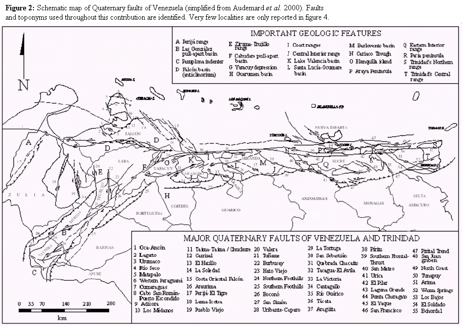
Figure 2: Schematic map of Quaternary faults of Venezuela (simplified from Audemard et al. 2000). Faults and toponyms used throughout this contribution are identified. Very few localities are only reported in figure 4.
The present Caribbean-South American geodynamic configuration results from a transpressive evolution that has occurred throughout the Tertiary and Quaternary, initiated as an oblique type-B subduction. The NW-dipping oceanic lithosphere, attached to northern South America, subducted obliquely under Caribbean plate island arc. This plate boundary zone later evolved into a long-lasting east-younging obliquecollision, where Caribbean-affinity nappes overrode towards the SSE, thus scrapping off passive-margin-affinity nappes and incorporating them into the tectonic pile, which in turn was all overthrusted onto the undeformed South America passive margin. More recently, this plate boundary converted into a partitioned transpression when and where collision became unsustainable (for more details refer to Audemard 1993, 1998). Its latest evolutionary stage is still active in Eastern Venezuela and Trinidad and marks the shift from oblique subduction to present-day partitioned oblique collision. This east-younging oblique convergent margin has acted diachronically throughout the evolution of this entire northern portion of the plate boundary (Audemard 2000) and clearly indicates that, through time, the plate boundary zone has progressively changed from a predominant compressive to a more wrenching type. This change started at around 17-15 Ma in northwestern Venezuela (Audemard 1993, 1998). The tectonically complex southeastern Caribbean is undergoing two major geodynamic processes: (a) strain partitioning characterized by NNW- trending shortening across the entire region from north of La Blanquilla island (O in Fig. 2) to the southernmost active thrust front of the Interior range and right-lateral strike-slip along the main east-west striking El Pilar and NW-SE striking Los Bajos-El Soldado faults, as well as along other minor parallel and/or synthetic Riedel shear faults (Fig. 2); and (b) slab detachment associated with an incipient type-A subduction (e.g., Russo and Speed 1992, Russo 1999; responsible for the largest onshore negative Bouguer anomaly of the world, located south of the southern edge of the Interior range). These processes concur with a plate boundary geometry such as the present one, where the El Pilar fault transfers its slip eastward to one of its synthetic Riedel shears (Los Bajos and El Soldado faults), which is acting as a "lithospheric tear fault", thus separating the transpressional boundary on the west from the conventional type-B Lesser Antilles subduction zone on the east. These two distinct seismotectonic domains were originally identified by Pérez and Aggarwal (1981). The different seismicity patterns support contrasting geodynamic contexts (oblique collision and oblique subduction roughly west and east of the Los Bajos-El Soldado fault system, respectively). Recent GPS findings by Weber et al. (2001) indicate that most of the strike-slip motion of the El Pilar fault is transferred onto the Warm Springs fault system of the Central Range of Trinidad rather than onto a fault south off Trinidad (Fig. 2). This would imply that the Paria gulf is functioning at present as a pull-apart basin bounded by the El Pilar and Warm Springs faults on the north and south respectively, at a releasing stepover. Both faults exhibit a similar slip rate, in the order of 8-10 mm/a (compare Audemard et al. 2000 and Saleh et al. under review). However, this crustal deformation does not exclude that a major plate boundary is underlying this region, as evidenced by the instrumental seismicity, a conclusion originally drawn by Pérez and Aggarwal (1981) and later confirmed by Sobiesiak et al. (2002).
As in eastern Venezuela, strain partitioning is also a common feature along the rest of the transpressional boundary zone. In the Mérida Andes, strain is nicely partitioned between the right-lateral strike-slip Boconó fault (BF) running slightly oblique along the axis of the chain and thrust faults bounding the chain on both flanks (Audemard and Audemard 2002). The north-central coastal ranges also exhibit strain partitioning, where dextral slip in the range core is accommodated by both the San Sebastián and La Victoria faults and other minor synthetic Riedel shears whereas transverse shortening is mainly taken by uplift and the frontal thrust faults bounding the chain along its southern edge, such as in the Guarumen basin (Cojedes state; Audemard 1999a).
A large portion of the dextral slip along this complex boundary seems to be presently accommodated by the major right-lateral strike-slip Boconó-San Sebastián-El Pilar- Los Bajos fault system or segments of it (Molnar and Sykes 1969, Minster and Jordan 1978, Pérez and Aggarwal 1981, Schubert 1980a and b, 1982, Stephan 1982, Aggarwal 1983, Schubert 1984, Soulas 1986, Beltran and Giraldo 1989, Singer and Audemard 1997, Audemard et al. 2000, Weber et al. 2001, Pérez et al. 2001). This slip is now known to be transferred farther east onto the Warm Springs fault system of central Trinidad (after Weber et al. 2001's results). It is still matter of debate whether this is either a transcurrent or transform system and depends on the authors and their proposed geodynamic models. Most authors accept or postulate this major rightlateral strike-slip fault system to be the plate boundary between the Caribbean and South America plates (e.g., Hess and Maxwell 1953, Schubert 1979, Aggarwal 1983, among many others), whereas few others propose different plate boundary models along this right-lateral strike-slip plate boundary zone: (a) orogenic float type for the Andes (Audemard, 1991, Jacome, 1994, Audemard and Audemard 2002, Fig. 3) or eastern Venezuelan Coastal and Interior ranges (Ysaccis et al. 2000), thus being flanked by both an A- and B-type subductions; and (b) SE-directed A-subduction or underthrusting of the Maracaibo block under the Mérida Andes (Kellogg and Bonini 1982, De Toni and Kellogg 1993, Colletta et al. 1996, 1997). However, the incorporation of the Boconó fault into this major right-lateral strike-slip fault system is a rather recent event, that relates to the northward extrusion of the Maracaibo block, because the former transcurrent boundary used to comprise the east-weststriking Oca-Ancón fault system (OAF) located farther north in northwestern Venezuela (Audemard 1993, 1998). Therefore, the Oca-Ancón fault system belonged to this major right-lateral strike-slip plate boundary zone along the southern Caribbean from when transpression started at around 17-15 Ma to when essentially ceased or considerably slowed down at around 5-3 Ma. Although the Caribbean with respect to South America is moving at rates between 12 mm/a in the west (geologic slip rate from Nuvel 1-A model) and 18 ± 2 mm/a in the east (GPS-derived slip rate by Weber et al. 2001), the present major strikeslip (Boconó-San Sebastián-El Pilar-Warm Spring faults) boundary slips at »1 cm/a (Pérez and Aggarwal, 1981; Soulas, 1986; Freymueller et al., 1993; Audemard et al., 2000; Pérez et al., 2001, Weber et al. 2001, Trenkamp et al. 2002). Secondary faults however have slip rates one order of magnitude less and in fact most of them exhibit slip rates under 0.5 mm/a, with the exception of the Oca-Ancón (2 mm/a, estimated from a paleoseismic assessment performed by Audemard, 1996), the Burbusay ( <3 mm/a), Valera and La Victoria ( <1 mm/a) faults (for more details, refer to Audemard et al. 2000, and to figure 2 for relative location).
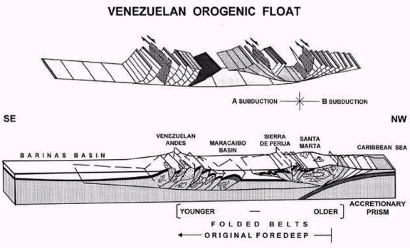
Figure 3: The orogenic float model applied to the Mérida Andes. Cross-section extends from the northwestern tip of the Santa Marta Block (SMB; location in Fig. 2) to the Llanos Basin, across the southernmost Mérida Andes, at the Pamplona indenter. Bottom figure displays major geologic units and structures, whereas top figure only exhibits major structures -brittle thrust and strike-slip faults, detachments and triangle zones- to give a more legible view of their interplays (after Audemard and Audemard 2002).
NEOTECTONIC MAPPING IN VENEZUELA
Active tectonics in Venezuela at present are driven by tectonic plate and microplate interactions, as explained in the introduction. Knowledge about the southern Caribbean plate boundary zone has much evolved from the original ideas of Hess and Maxwell (1953), when a rather simple dextral wrenching system had been proposed. Over twenty years of neotectonic analysis comprising studies in the disciplines of surface geology, geomorphology, microtectonics, seismotectonics and paleoseismology, combined with data from conventional geologic studies and seismic reflection surveying both onshore and offshore, now give us a more complete understanding of the complex active geologic setting in Venezuela and surrounding areas.
Neotectonics in Venezuela, as for everywhere else in the world, is defined as the tectonics resulting from the most recent and still active stress field. On this basis, Venezuelan neotectonics refer to the tectonics of the Quaternary (after Soulas 1986), implying that tectonic features that either show no evidence of activity during that timeframe or have an orientation not susceptible to reactivation in the near future under the present stress regime, are not included in this compilation. The latest version of the neotectonic (Quaternary fault) map depicted in figure 4 is the third version of this type of maps (Audemard et al. 2000), the first version having been elaborated by Soulas in 1985, and published in 1986 (Soulas 1986), which was later updated by Beltran (1993) as the second version. The latest version differs from the previous ones in three important aspects: (a)- New neotectonic data corresponding to onshore areas studied by Funvisis between 1993 and 1999 have been incorporated. They include data on the southern frontal thrusts of the Interior range in eastern Venezuela and the southern foothills of the Mérida Andes, as well as a preliminary assessment of the inner active deformation of the triangular block defined by the Oca-Ancón, Boconó and Valera faults; (b)- A reinterpretation of the San Sebastián-El Pilar relay at the Cariaco trough in accordance with the interpretation of Blanco and Giraldo (1992); and (c) The map has been simplified in terms of the number of faults (imposed by the aim of the ILP-II-2 project), particularly in the Colombia-Venezuela border area, known as the Pamplona indenter -PI-. On the other hand, faults exhibit more detail both with respect to their Quaternary kinematics as to their discrimination by age of latest activity and slip rate, which allows easy and quick identification of the major active features. The map is complemented with a database that contains relevant information about each fault and/or fault section (length, attitude, age, sense of slip, slip rate, geomorphic expression, latest activity from geologic data, and so on) and its seismogenic potential (maximum credible earthquake and its recurrence). For more details, the reader is referred to the USGS web page.
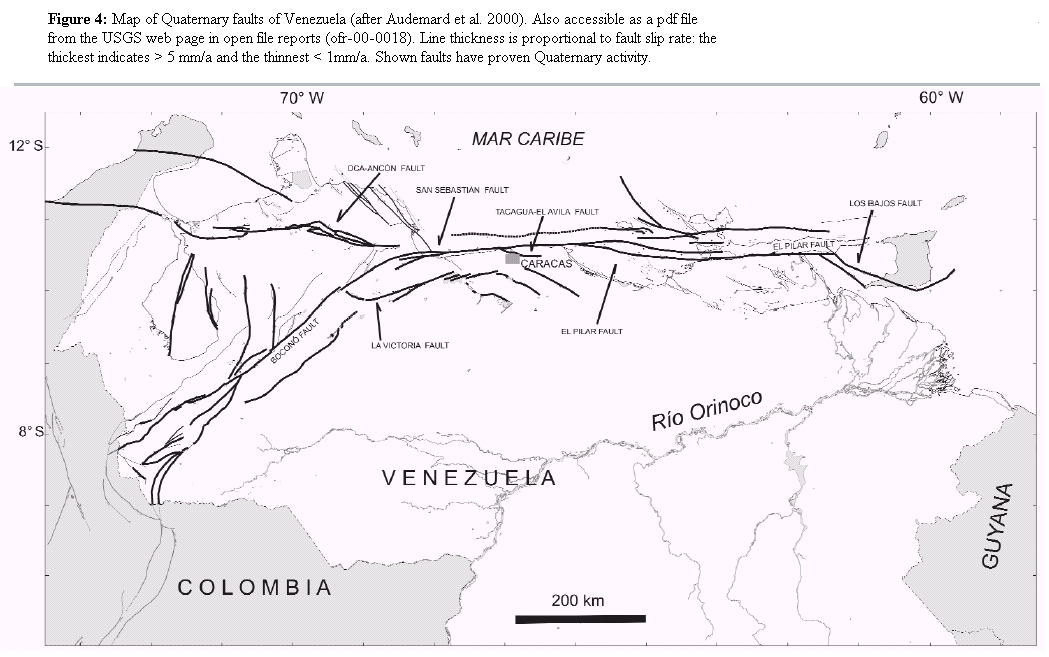
Figure 4: Map of Quaternary faults of Venezuela (after Audemard et al. 2000). Also accessible as a pdf file from the USGS web page in open file reports (ofr-00-0018). Line thickness is proportional to fault slip rate: the thickest indicates > 5 mm/a and the thinnest < 1mm/a. Shown faults have proven Quaternary activity.
QUATERNARY TECTONICS OF VENEZUELA
As mentioned earlier, most of northern and western Venezuela is situated in a complex plate boundary zone. Due to this complexity, we shall discuss in this paper only the most relevant aspects of the Quaternary Venezuelan tectonics. Figure 2 portrays all names of the active tectonic features used throughout this paper, while figure 4 (Audemard et al. 2000) represents the version of the map of the ILP project and gives further details on the Quaternary activity and relevance of only the major Quaternary features of Venezuela. In the following, we shall present the main issues drawn from these two figures.
The Quaternary deformation does not occur all over the country. Instead, strain is concentrated along localized strips or belts (Singer and Audemard 1997); all of them located in western and northern Venezuela. Most of these mobile belts exhibit high positive relief, implying an important amount of shortening along the plate boundary. It does not exclude however that some belts show negative relief but such features are always of more local extent.
The most conspicuous mobile belt is at least 100 km wide and runs over 1200 km in length from the Colombian border near San Cristobal in the southwest into Trinidad in the east. This major belt -which seems to be the prolongation of the Eastern Cordillera of Colombia- corresponds to an alignment of mountain chains that comprises from southwest to east: the NE -trending Mérida Andes and the E-W-oriented Coast and Interior ranges both in north-central and northeastern Venezuela. This belt exhibits a first-order dextral fault system that mostly runs along the chain's backbone over a distance of more than 1200 km and comprises the NE-trending Boconó fault in the Andes section (VE-06 in Fig. 4), and both the E-W-striking San Sebastián fault (VE-16 in Fig. 4) in central Venezuela and the El Pilar fault (VE-13 in Fig. 4) in eastern Venezuela (Singer and Audemard 1997). Most of the dextral slip between the Caribbean and South America plates is accommodated by this fault system. In fact, this fault system moves at about 1 cm/a when most other faults slip slower than a 1 mm/a (Audemard et al. 2000, Pérez et al. 2001). The combination of this rather fast slip rate and the significant length of the Boconó- San Sebastián-El Pilar fault system translates into an associated seismicity of moderate frequency and magnitude and is considered to be responsible for most large (Ms > 7) historical earthquakes that have struck the country since the first ever reported event in 1530. Fault rupture is concentrated in some particular segments of this plate boundary (e.g., Rod 1956, Cluff and Hansen 1969, Aggarwal 1983, Audemard 1997a, Pérez et al. 1997, Audemard 1999b, Audemard 2002). Some secondary mobile zones branch off from the major one. The most important of these are: the E-W-striking dextral Oca-Ancón fault system (VE- 01 in Fig. 2) in northwestern Venezuela and three NW trending normal-dextral fault systems respectively located from west to east in eastern Falcón, along the submarine canyon of Los Roques and in the gulf of Paria. The three latter ones constitute the principal areas of negative relief due to the significant normal component involved. Another deformation belt is the NNE-trending Perija range in westernmost Venezuela, whose crestline defines the borderline with Colombia.
The major Boconó-San Sebastián-El Pilar fault system displays several structural complexities of kilometric to several-kilometre scale, either in transtension (pull-apart basins such as those of La González/San Juan de Lagunillas -south of Mérida-, Cabudare, Cariaco trough and the gulf of Paria among others; refer to Fig. 2 for relative location), or in transpression (Caiguire hills at Cumaná, and Las Manoas and Guarapiche -west and east of the 1997 epicentre, respectively, in Fig. 4-; all in Sucre state, in eastern Venezuela and related to the El Pilar fault). In fact, this major wrenching fault system has no major complication of regional scale, except for both ends (Singer and Audemard 1997). In the west, at the Colombia-Venezuela border, the Boconó fault bends into the Pamplona indenter (as defined by Boinet 1985). Here, the Boconó fault sharply changes orientation to connect with the N-S-striking Chitaga fault, which shows a strong reverse slip when joining the Boconó fault, but progressively becomes a dominant left-lateral fault towards the south. Farther south, slip is transferred to the NW-trending sinistral Pamplona- Chucarima-Morro Negro fault system (CO-37 in Fig. 4). On the other extreme in the east, in the Paria gulf and Trinidad, the major right-lateral strike-slip fault system also bends rather sharply, 45o clockwise this time. The fault system splays into several NW-striking offshore faults - among which are the Los Bajos (VE-15 in Fig. 4), El Soldado and Bohordal faults (in Fig. 2)- that exhibit both normal and dextral components. Los Bajos-El Soldado fault system is claimed to link the major transcurrent fault system to the southern tip of the type-B Lesser Antilles subduction; hypothesis that is not necessarily shared by Weber et al. (2001), who postulate that slip transfer takes place along the Warm Springs fault of the Central Range of Trinidad from repeated GPS measurements. At this eastern tip, the El Pilar fault also shows a splay in the north compartment that branches off towards ENE. This splay, named the Tunapuy fault, exhibits a dominant reverse component with minor dextral slip. Beltran (1998) proposes that the reverse Tunapuy fault in the Paria peninsula prolongs into the reverse Arima fault of northern Trinidad that bounds the southern foothills of the Northern range of Trinidad (Fig. 2). Weber et al. (2001b) have demonstrated that the Arima fault, based on calcite and quartz geothermometry applied to south-dipping shear bands and cataclastic zones studied along the southern border of the Northern range in Trinidad, is a south-dipping rangebounding normal fault, whose activity as such could only be constrained between 12 and 1 Ma. However, the results of studies by Saleh et al. (under review), based on geodetic data (triangulation and GPS data merging), argue for a reverse slip along the Arima fault. This would seem to confirm the Arima fault slip determined from aerialphoto interpretation based on landforms of Quaternary activity performed by Beltrán (1998).
Several second-order faults of considerable length diverge obliquely from the major right-lateral strike-slip fault system. Many of these are considered to function simply as large synthetic Riedel shears related to the principal deformation zone marking the direct Caribbean-South America plate interaction in north-central and northeastern Venezuela. The best known faults of this type are: the Río Guárico (VE-09 in Fig. 4), Tacagua-El Avila (VE-10 in Fig. 4), Tácata (VE-11 in Fig. 4), Píritu (VE-12 in Fig. 4), San Mateo (Jose; VE-14 in Fig. 4), Urica and San Francisco faults, among several others. In the Mérida Andes, along the Boconó fault, there is no manifestation of such large Riedel shears, although there are many branching faults. Among them deserve mention the north-south-striking sinistral Valera (VE-04 in Fig. 4) and Burbusay faults and the subparallel dextral Caparo fault (SE of San Cristobal; Fig. 2). The presence of R shears, in this case in association with the Oca-Ancón fault system, also happens in the Falcón range. Dextral slip is also accommodated by sub-parallel-trending faults to the main right-lateral strike-slip fault system. For instance, the San Simon and Caparo faults in the Andes run parallel to the Boconó fault. In north-central Venezuela, the La Victoria fault acts as a P shear with respect to the San Sebastián fault. The North Coast in eastern Venezuela is also dextral and runs north of and parallel to the el Pilar fault.
In the north-central and eastern mobile belts, few faults exhibit left-lateral strikeslip. The Quebrada Chacaito fault trends almost north-south, north of Caracas, but other slightly oblique faults to the main dextral system in northeastern Venezuela also exhibit sinistral motion. A case in point constitutes the Punta Charagato fault in the Cubagua island, and the Laguna Grande fault in the Araya peninsula (Giraldo and Beltrán 1989). The orientation and slip of these left-lateral strike-slip faults seem atypical with respect to their tectonic setting in northeastern Venezuela. These ENE-striking faults, in combination with the eastwest striking dextral faults, bound wedgeshaped tectonic blocks, whose acute angle points to between ENE and east. Some blocks in this region show a slip vector that slightly diverges to ENE (N084° ± 2°E after Pérez et al. 2001), which matches rather well with the orientation of the bisecting line between both fault trends. This could argue for the occurrence of block extrusions to some extent in this complex southeastern corner of the Caribbean in order to reduce mass excess. This would give a satisfactory explanation to the apparent transtension postulated by other authors from GPS vectors (e.g., Weber et al. 2001), when transpression is actually the operating mechanism at plate-boundary scale.
Active thrust faults are present along most chain fronts, although they may be blind or hidden behind triangular zones or intracutaneous wedges. They have been detected onshore along the northern edge of the presently inverted Falcón basin (south of Coro), along the foothills on both flanks of the Mérida Andes and along the southern front of the Interior range both in central (e.g., Cantagallo overthrust) and eastern (e.g., Pirital and sub-parallel thrusts) Venezuela (Figs. 2 and 4). Other manifestations of compression are chain uplift and buildup, and intense folding in sedimentary sequences like in the Falcón basin ("D" in Fig. 2), the eastern Interior range ("Q" in Fig. 2), the Andes foothills, and even in the Neogene-Quaternary foreland sequence of the central Interior range.
Normal faults are also common and widespread within the deformation belts. Tuname in the Mérida Andes (VE-05 in Fig. 4), Los Médanos (north of Coro), Cabo San Román and Puerto Escondido (north tip of the Paraguana peninsula in northwestern Venezuela) and the Río San Juan graben (in eastern Venezuela) faults are some examples of normal faulting (refer to Fig. 2 for location). Except for the Tuname fault located in the Andes (Figs. 2 and 4), all other normal faults in northern Venezuela strike NNW. Instead, the normal slip of the Tuname fault -that roughly strikes ENE and is located at the convergence of the Valera and Boconó faults- is a consequence of a void effect induced by a bookshelf rotation mechanism produced by simple shear between the Oca-Ancón and Boconó faults. Dhont et al. (2005) propose instead that the axial extension within the central Andes, involving the Tuname fault, responds to the northward escape of the Trujillo block, bounded between the north-south-striking left-lateral Valera fault on the west and the NE-SW-trending right-lateral Boconó fault on the east (Figs. 2 and 4).
In western Venezuela, the mobile belt is much wider than in northern Venezuela, reaching up to 600 km in width, and comprising the entire Maracaibo block (MTB) that covers also part of northern Colombia (Audemard, 2000; Audemard et al., 2000). This block is bounded by the sinistral Bucaramanga fault (SMBF in Fig. 1) on the southwest and the dextral Boconó and Oca-Ancón faults. Other authors consider the northern boundary of the block to be the flat subduction (LAS in Fig. 1), responsible for the Southern Caribbean Deformation Belt (SCDB) established from seismic tomographic studies by Van der Hilst (1990), rather than the Oca-Ancón fault system (OAF in Fig. 1). In Venezuelan territory, this block contains two deformation belts with positive relief: the Perijá range and the western part of the Mérida Andes, between which the Maracaibo basin is being squeezed and shortened in NW-SE direction. The Perijá range happens to be the least studied area until the present-day in terms of active tectonics because of poor accessibility and personal security problems.
The triangular Maracaibo block (MTB) shows an intense internal fragmentation where blocks are individualized by north-south to NE-SW trending faults. Most of these faults are essentially left-lateral in slip, with a minor thrust component in many cases, such as from west to east: Icotea, Pueblo Viejo, Valera, Burbusay, among others. This structural and geometrical configuration may result from a bookshelf rotation mechanism induced by simple shear generated between the dextral Boconó and Oca-Ancón faults (Audemard et al. 1999, 2005). But the two faults are not parallel and are at an angle of 45o, which is an atypical configuration that must result in particular complex deformations, as well as switching the sense of slip along faults through time.
The spatial configuration of the faults and folds at regional scale and their kinematics, as deduced solely from the neotectonic mapping, points out that the Northern Falcón basin (northwestern Venezuela) is undergoing a stress tensor with a NNWSSE to N-S maximum horizontal stress and an ENE-WSW minimum (or intermediate) horizontal stress (Audemard 1993, 1997b, 2001; Audemard et al. 2005). This would mean that the simple shear model associated with strike-slip faulting proposed by Wilcox et al. (1973) applies. Regional folding in this region does not only result from wrenching, as proposed by many authors (e.g.: Stephan 1982), but also from regional compression. Both folding due to wrenching in close association with the Oca- Ancón fault system (transpression s.s.) and to regional compression occur together (transpression s.l.). The neotectonic mapping in this region also permits the determination of active brittle structures in five distinguishable families based on their orientation and kinematics (Audemard, 1993, Audemard and Singer 1996, Audemard 1997b, 2001; Figs. 2 and 4): (1) East-West right-lateral faults (Oca-Ancón Fault System -VE-01-, Adicora Fault); (2) NW-SE right-lateral faults, as synthetic Riedel shears to the east-west faults (Urumaco -VE-02-, Rio Seco -VE-03-, and La Soledad faults); (3) NNW normal faults (Western Paraguana, Cabo San Roman, Puerto Escondido and Los Médanos faults, all faultbounding the Paraguaná peninsula); (4) North to NNE left-lateral faults, antithetic to the east-west faults (Carrizal, El Hatillo and other minor faults); and (5) ENE reverse faults, parallel to fold axis of similar orientation (Araurima, Taima-Taima/Chuchure and Matapalo faults). In terms of slip rate, most Quaternary tectonic features in Northern Falcón are rather slow, showing slip rates generally below 0.4 mm/a. The major Oca-Ancón fault system is the exception to this, with a maximum slip rate close to 2 mm/a (Audemard 1993, Audemard and Singer 1994, Audemard et al. 1994, Soulas and Giraldo 1994, Audemard 1996, Audemard and Singer 1996, Audemard et al. 2000).
The Coast and Interior ranges of northcentral and eastern Venezuela is the only portion of the plate boundary zone to result from rather simple direct interaction between the Caribbean and South America plates. The same applies to northwestern Venezuela as registered in the Falcón basin and applicable at larger scale to the Bonaire block confined between the Leeward Antilles subduction and the Oca-Ancón fault system. Therefore, this region also complies with the simple shear model, at least as far as the brittle tectonics is concerned, with strain partitioning also occurring along this plate boundary segment. Within the Mesozoic metamorphic SSE-overthrusted nappes of central Venezuela, six families of active tectonic features are distinguishable on the basis of their orientation and present kinematics (Figs. 2 and 4): (1) East- West right-lateral faults (San Sebastián, La Tortuga and El Avila faults); (2) NW rightlateral faults, synthetic to the east-west faults (Río Guárico -VE-09-, Tácata -VE- 11- and Aragüita faults; (3) NW to NNW normal-dextral to dextral-normal faults (Píritu -VE-12- and Tacagua -VE-10- faults); (4) North to NNE left-lateral faults, antithetic to the main east-west faults (Quebrada Chacaito faults); (5) ENE reverse faults, parallel to fold axis (Nappe fronts, among which the Cantagallo overthrust); and (6) ENE to E dextral faults -P shears- (La Victoria fault -VE-08-). This is actually the only case of active P faulting recognized in the plate boundary zone.
For eastern Venezuela, the configuration of the active structures is as follows (Figs. 2 and 4): (1) East-West right-lateral faults (El Pilar -VE-13-, El Yaque and North Coast faults); (2) NW right-lateral faults, synthetic to the main east-west faults (San Mateo - VE-14-, Urica and San Francisco faults); (3) NW to NNW normal-dextral to dextralnormal faults (San Juan Graben, Bohordal, Los Bajos and El Soldado -VE-15- faults); (4) ENE left-lateral faults, which do not obey the simple shear model (Laguna Grande and Punta Charagato faults; issue discussed earlier in this paper); and (5) ENE reverse faults, parallel to fold axis orientation (frontal thrust of the Interior range, among which the Pirital thrust stands out).
All present deformations along northern Venezuela are related to the WNW oriented oblique convergence vector of the Caribbean plate with respect to South America (e.g.: N 75° W, after Minster and Jordan 1978; later confirmed by many others from GPS data, as indicated earlier). Meanwhile, western Venezuela presents a more complex scenario that shall be discussed later in this paper that reflects the influence of the convergence vector between the Nazca and South America plates to the southwest in Colombian territory.
QUATERNARY STRESS TENSORS OF VENEZUELA
Audemard et al. (2005) have recently published a nationwide stress tensor compilation derived from fault-plane kinematic indicators. In order to ascertain the characterization of the latest and still active tectonic phase, this compilation has only integrated stress tensors derived from Plio-Quaternary sedimentary rocks (refer to Table 1 in Audemard et al. 2005). This approach has relied on an inversion method, through which the stress tensor has been obtained from the measured strain. Those tensors were calculated with either the Etchecopar et al. (1981)'s method or the right dihedral method designed by Angelier and Mechler (1977). This latter method is less accurate than that of Etchecopar et al. (1981), which is also capable of establishing the qualitative shape of the stress tensor ellipsoid through the value of "R", being R defined as (s2 - s3)/(s1- s3). The principal stress in vertical position indicates the dominant tectonic regime but R helps to better define it (refer to Ritz 1991, for more details). From this tectonic stress inversion, Audemard et al. (2005) reach the following general conclusions:
(1)- northern Venezuela -covering the Falcón basin and the central and eastern Coast and Interior ranges from west to east- is characterized by a Plio-Quaternary stress tensor of rather uniform and constant orientation throughout. The prevailing orientations of this tensor are NW to NNW (145° to 170°) for the maximum horizontal stress (sH) and NE to ENE for the minimum horizontal stress (sh). Therefore, there is a good consistency among stress tensors at regional scale. This geologically derived tensor mostly represents a transcurrent regime (intermediate stress in vertical position). Where the Etchecopar et al.'s method was applied, as in the case of the Falcón region, the stress regime can be constrained better and is of the compressive transcurrent type (Audemard 1991, 1993, 1997c and 2001). Some authors describe this tectonic regime as transpressive and refer to the enlarged sense of the term and do not restrict its use only to the localized stress changes introduced by strikeslip motion in proximity of or along the wrench fault. This stress tensor is highly oblique to the general east-west trend of the major wrench faults of northern Venezuela (Oca-Ancón, San Sebastián and El Pilar faults). This strong obliquity is responsible, on the one hand for the occurrence of strain partitioning (right-lateral strike-slip along east-west trending faults and transverse shortening in NNW-SSE direction). On the other hand, it is also responsible for simultaneous left-lateral strike-slip motion on faults that are slightly oblique to the east-west trending dextral faults, as is the case of the WSW-ENE-striking Punta Charagato and Laguna Grande faults in eastern Venezuela (Fig. 2). The consistency of the stress-tensor orientation along northern Venezuela from west to east (from northwestern Colombia to Trinidad) permits the identification of local variations of the stress regime. Most of these local stress changes coincide with known transtensional geometries, or occasionally with transpressional geometries (refer to Audemard et al. 2005 for further details). These changes are easily identifiable because the stress tensor orientation remains essentially constant but their principal stress magnitudes vary (stress tensor permutation, where maximum and intermediate stresses may interchange positions).
(2)- The stress tensor calculated by either the Etchecopar et al. (1981)'s automated method or the right dihedral method of Angelier and Mechler (1977) well represents the stress field for the present-day kinematics of seven major families of active faults along northern Venezuela: (a) eastwest right-lateral faults; (b) NW right-lateral faults, synthetic to the east-west faults; (c) NNW normal faults; (d) NW to NNW normal- dextral to dextral-normal faults; (e) North-South to NNE-SSW left-lateral faults, antithetic to the east-west faults; (f) ENE to east-west right-lateral faults -P shears-; and (g) ENE reverse faults, paralleling the axis of active folds. Spatial configuration of these brittle tectonic structures indicates that the region is undergoing a transpressional s.l. (compressive-transcurrent) regime that complies with the simple shear model proposed by Wilcox et al. (1973). Therefore, this regional configuration is related to the slightly oblique convergence between the Caribbean and South America plate in the west and almost perfect wrenching in eastern Venezuela with some "apparent" transtension (Pérez et al. 2001 and Weber et al. 2001), that is directly responsible for east-west trending dextral wrenching along northern Venezuela. On the other hand, in northwestern Venezuela there is convergence between the Bonaire block (BB) and the Caribbean plate in a process of flat subduction located offshore of the Leeward Antilles islands (LAS), which operates in concurrence with the NNE directed extrusion of the Maracaibo and Bonaire blocks. Overall there is good agreement between stress tensors obtained from microtectonic data and large scale neotectonic mapping.
(3)- sH in the northern Mérida Andes (Lara state), in proximity to the Boconó fault, tends to become east-west oriented, which allows the simultaneous functioning of the NE-striking dextral (e.g.: Boconó, Caparo, San Simón) faults, the equally-trending thrust faults along both Mérida Andes foothills and the north-south striking sinistral faults (e.g., Valera and Burbusay, among several others; Fig. 2).
(4)- As a result of this, the stress field on the Maracaibo block (MTB) progressively turns counterclockwise from a NNW trend in the north (Beltran and Giraldo 1989, Audemard 2001, Audemard et al. 2005) to east-west oriented to the south (Audemard et al. 1999), making it resemble a folding fan with vertex pointing to the SE (Giraldo 1990, Audemard and Audemard 2002). The orientation of this regional stress field in western Venezuela results from the superposition of the two major neighbouring interplate maximum horizontal stress orientations ( sH ): (1) a roughly east-west trending stress across the Nazca-South America type-B subduction along the pacific coast of Colombia and (2) a NNW-SSE oriented stress across the southern Caribbean plate boundary (Audemard 2000, Fig. 1). As a result, the Maracaibo block is simultaneously being shortened along the NW direction (expressed by the vertical growth of the Santa Marta block and Perija and Mérida ranges) and extruded to the NNE (Audemard 1993, 1998, 2000b, Audemard and Audemard 2002).
DISCUSSION AND CONCLUSIONS
The stress tensors derived from microtectonic data collected in Plio-Quaternary rocks and those derived from the spatial configuration of Quaternary active faults are in good agreement. On the one hand, deformation along the southern Caribbean coast results from a compressive strike-slip (transpressional s.l.) regime characterized by a NNW-SSE maximum horizontal stress (sH=s1) and/or an ENE-WSW minimum (sh= s3 or s2) horizontal stress. This configuration gives rise to the present activity and kinematics of seven sets of brittle and ductile features: (1) east-west right-lateral faults, (2) NW right-lateral faults or synthetic Riedel shears, (3) ENE to east-west dextral faults or P shears, (4) NNW normal faults, (5) almost north-south left-lateral faults or antithetic Riedel shears , (6) ENE reverse faults -sub-parallel to fold axes and mostly in the subsurface- and (7) associated ENE trending folds (well-developed in the Falcón basin -northwestern Venezuela- and the Interior range in the east). The main exceptions to this general configuration are found in eastern Venezuela: the Punta Charagato and Laguna Grande faults that display left-lateral slip along the ENE direction. This "apparent" inconsistency may be explained by using a ENE-directed block escape model. In most of northern Venezuela, brittle deformation obeys the simple shear model.
On the other hand, the stress field on the Maracaibo block progressively turns counter- clockwise to become more east-west oriented, allowing left- and right-lateral slip along north-south and NE-SW striking faults, respectively. This regional stress field in western Venezuela results from the superposition of the two major neighbouring interplate maximum horizontal stresses (sH) related to the Nazca plate type-B suduction and NNW-SSE oriented stress across the southern Caribbean plate boundary. This results in the Maracaibo block simultaneously being shortened on the NW direction and extruded roughly towards the NNE.
Wrenching is the dominant geodynamic process, but it is always accompanied by compression of variable magnitude along strike of the major strike-slip fault system, proving that stress (or strain) partitioning is the actuating mechanism. Only locally, transtension becomes significantly important, such as in the Cariaco trough and gulf of Paria in association with the El Pilar fault. It can now be firmly established that the GPS slip vectors do not only support the hypothesis of ongoing transpression along most of this complex plate boundary zone, but also tend to confirm most of the active fault slip rates derived from geologic and neotectonic studies carried out in Venezuela for almost 25 years by the Funvisis staff.
ACKNOWLEDGEMENTS
This long-term research would have not been possible without the continuous funding from Funvisis that allowed most of the dataset collection and generation. Perseverance of the personnel of the Earth Sciences Department of FUNVISIS throughout the years made possible this achievement. The Venezuelan Oil Industry (PDVSA and former affiliates) is also greatly acknowledged for providing additional funding. Marina Pena is thanked for her drawings. This paper is partly a contribution to FONACIT projects G-2002000478 and PI-2003000090, although funding was provided by other sources.
WORKS CITED IN THE TEXT
Aggarwal, Y. 1983. Neotectonics of the Southern Caribbean: Recent Data, new ideas. Acta Cientifica Venezolana, Abstract 34 (1):17. [ Links ]
Angelier, J. and Mechler, P. 1977. Sur une méthode graphique de recherche des contraintes principales également utilisable en tectonique et séismologie: la méthode des diedres droits. Bulletin Societé Géologique de France 19(6): 1301-1318. [ Links ]
Audemard, F. A. 1991. Proyecto suministro Falcón-Zulia (SUFAZ): Actividad cuaternaria y caracterización sismogénica de las fallas de Lagarto y Río Seco. Afinamiento de las características sismogénicas del sistema de fallas de Oca-Ancón y de Urumaco. Unpublished Funvisis' report for Maraven; 91 p. [ Links ]
Audemard, F. A. 1993. Néotectonique, Sismotectonique et Álea Sismique du Nordouest du Vénézuéla (Systéme de failles d'Oca-Ancón). PhD. thesis, Université Montpellier II, France, 369 p. [ Links ]
Audemard, F. A. 1996. Paleoseismicity studies on the Oca-Ancón fault system, northwestern Venezuela. Tectonophysics 259: 67-80. [ Links ]
Audemard, F. A. 1997a. Holocene and Historical Earthquakes on the Boconó Fault System, Southern Venezuelan Andes: Trench Confirmation. Journal of Geodynamics 24(1-4): 155-167. [ Links ]
Audemard, F. A. 1997b. Tectónica activa de la región septentrional de la cuenca invertida de Falcón, Venezuela occidental. Proceedings 8° Congreso Geologico Venezolano, Porlamar, 1:93-100. [ Links ]
Audemard, F. A. 1998. Evolution Géodynamique de la Façade Nord Sud-américaine: Nouveaux apports de l'Histoire Geologique du Bassin de Falcón, Vénézuéla. Proceedings 14°Caribbean Geological Conference, Trinidad, 1995, (2): 327-340. [ Links ]
Audemard, F. A. 1999a. Morpho-structural expression of active thrust fault systems in the humid tropical foothills of Colombia and Venezuela. Zeitschrift fur Geomorphologie 118, 1-18. [ Links ]
Audemard, F. A.1999b. Nueva percepción de la sismicidad histórica del segmento en tierra de la falla de El Pilar, Venezuela nororiental, a partir de primeros resultados paleosísmicos. Proceedings 6°Congreso Venezolano de Sismología e Ingeniería Sísmica, Mérida, (in CD-Rom). [ Links ]
Audemard, F. A. 2000. Major Active Faults of Venezuela. Proceedings 31st International Geological Congress (extended abstract; in CD-Rom) 4 p. Rio de Janeiro. [ Links ]
Audemard, F. A. 2001. Quaternary tectonics and present stress tensor of the inverted northern Falcón Basin, Northwestern Venezuela. Journal of Structural Geology 23: 431- 453. [ Links ]
Audemard, F. A. 2002. Ruptura de los grandes sismos históricos venezolanos de los siglos XIX y XX revelados por la sismicidad instrumental contemporánea. Proceedings 11°Congreso Venezolano de Geofisica 8 p. (CD-Rom format). [ Links ]
Audemard, F. A. and Singer, A. 1994. Parámetros sismotectónicos para fines de evaluación de la amenaza sísmica en el noroccidente de Venezuela. Proceedings 7°Congreso Venezolano de Geofísica, 51-56, Caracas. [ Links ]
Audemard, F. A. and Singer, A. 1996. Active fault recognition in northwestern Venezuela and its seismogenic characterization: neotectonic and paleoseismic approach. Geofisica Internacional 35, 245-255. [ Links ]
Audemard, F. A. and Singer, A. 1997. La Ingeniería de Fallas Activas en Venezuela: historia y estado del arte. Seminario Internacional de Ingeniería Sísmica: Aniversario del Terremoto de Caracas de 1967. Universidad Catolica Andres Bello, 11-27, Caracas. [ Links ]
Audemard, F. A., Romero G. and Rendon, H. 1999. Sismicidad, Neotectónica y Campo de Esfuerzos del Norte de Venezuela. Unpublished Funvisis' report for PDVSA-CVP, 221 p. [ Links ]
Audemard, F. A., Romero, G. Rendon, H. and Cano, V. 2005. Quaternary fault kinematics and stress tensors along the southern Caribbean from microtectonic data and focal mechanism solutions. Earth-Science Reviews 69(3-4): 181-233. [ Links ]
Audemard, F. A., Singer, A., Rodriguez, J. A. and Beltran, C. 1994. Definición de la traza activa del sistema de fallas de Oca-Ancón, noroccidente de Venezuela. Proceedings 7° Congreso Venezolano de Geofísica, 43-50, Caracas. [ Links ]
Audemard, F. A., Machette, M., Cox, J., Dart, R. and Haller, K. 2000. Map and Database of Quaternary Faults and Folds in Venezuela and its Offshore Regions. USGS Open-File report 00-0018 (accesible from USGS webpage: http://greenwood.cr.usgs.gov/pub/ open-file-reports/ofr-00-0018). [ Links ]
Audemard, F. E. 1991. Tectonics of Western Venezuela. PhD. thesis, Rice University (unpublished) 245 p. [ Links ]
Audemard, F. E. and Audemard, F. A. 2002. Structure of the Mérida Andes, Venezuela: relations with the South America-Caribbean geodynamic interaction. Tectonophysics 345, 299-327. [ Links ]
Bell, J. 1972. Geotectonic evolution of the southern Caribbean area. Geological Society of America, Memoir 132: 369-386. [ Links ]
Beltrán, C. (comp.) 1993. Mapa Neotectónico de Venezuela. Escala 1: 2,000,000. Funvisis. [ Links ]
Beltrán, C. 1998. Preliminary observations on Quaternary reverse faulting along the southern foothills of the Northern Range of Trinidad. Proceedings 14° Caribbean Geological Conference, 1995, 1: 233-239, Trinidad. [ Links ]
Beltrán, C. and Giraldo, C. 1989. Aspectos neotectónicos de la región nororiental de Venezuela. Proceedings 7°Congreso Geologico Venezolano, 3:1000-1021, Barquisimeto. [ Links ]
Blanco, B. and Giraldo, C. 1992. Síntesis tectonoestratigráfica de la cuenca Tuy-Cariaco y plataforma externa. Proceedings 6°Congreso Venezolano de Geofisica, 1:47-54, Caracas. [ Links ]
Boinet, T. 1985. La Frontière Méridionale de la Plaque Caraibe aux confins Colombo-Venezueliens (Norte de Santander, Colombie): Données Geologiques. PhD. thesis, Universite Paris VI. 204 p. [ Links ]
Cluff, L. and Hansen, W. 1969. Seismicity and Seismic-Geology of northwestern Venezuela. Unpublished Woodward-Clyde's report for Shell. 2 volumes. [ Links ]
Colletta, B., Roure, F., De Toni, B., Loureiro, D., Passalacqua, H. and Gou, Y. 1996. Tectonic inheritance and structural styles in the Mérida Andes (western Venezuela). 3°International Symposium on Andean Geodynamics 323- 326, Saint-Malo. [ Links ]
Colletta, B., Roure, F., De Toni, B., Loureiro, D., Passalacqua, H. and Gou, Y. 1997. Tectonic inheritance, crustal architecture, and contrasting structural styles in the Venezuelan Andes. Tectonics 16(5), 777-794. [ Links ]
De Toni, B. and Kellogg, J. 1993. Seismic evidence for blind thrusting of the northwestern flank of the Venezuelan Andes. Tectonics 12(6): 1393-1409. [ Links ]
Dhont, D., Backe, G. and Hervouet, Y. 2005. Plio-Quaternary extension in the Venezuelan Andes: Mapping from SAR JERS imagery. Tectonophysics 399: 293-312. [ Links ]
Etchecopar, A., Vasseur, G. and Daignieres, M. 1981. An inverse problem in microtectonics for the determination of stress tensors from fault striation analysis. Journal of Structural Geology 3: 51-65. [ Links ]
Freymueller, J. T., Kellogg, J. N. and Vega, V. 1993. Plate motions in the north Andean region. Journal of Geophysical Research 98: 21853-21863. [ Links ]
Giraldo, C., 1990. Determinación del campo actual de esfuerzos en la región caribe, a partir de datos sismológicos y neotectónicos. 5°Congreso Venezolano de Geofisíca, Proceedings 70-77, Caracas. [ Links ]
Giraldo, C. and Beltran, C. 1989. La falla de Laguna Grande (Edo. Sucre): Tectónica cuaternaria y campo de esfuerzos asociado. GEOS 29: 195-204. [ Links ]
Hess, H. and Maxwell, J. 1953. Caribbean Research Project. Bulletin of the Geological Society of America 64(1): 1-6. [ Links ]
Jacome, M. I. 1994. Interpretación geológica, sísmica y gravimétrica de un perfil transandino. Undergraduate thesis, Universidad Simon Bolivar, 68 p., Caracas. [ Links ]
Jordan, T. 1975. The present-day motions of the Caribbean plate. Journal of Geophysical Research 80: 4433-4439. [ Links ]
Kaniuth, K., Drewes, H., Stuber, K., Temel, H., Hernandez, J. N., Hoyer, M., Wildermann, E., Kahle, H. G. and Geiger 1999. Position changes due to recent crustal deformations along the Caribbean-South American plate boundary derived from CASA GPS project. General Assembly of the International Union of Geodesy and Geophysics (IUGG), Birmingham, U.K. Poster at Symposium G1 of International Association of Geodesy. [ Links ]
Kellogg, J. and Bonini, N. 1982. Subduction of the Caribbean Plate and Basament Uplifts in the overriding South-American Plate: Tectonics 1(3): 251-276. [ Links ]
Kellogg, J. and Vega, V. 1995. Tectonic development of Panama, Costa Rica, and the Colombian Andes: Constraints from Global Positioning System geodetic studies and gravity. Geological Society of America, Special Paper 295: 75-90. [ Links ]
Malfait, B. and Dinkelman, M. 1972. Circum-Caribbean tectonic and igneous activity and the evolution of the Caribbean plate. Geological Society of America Bulletin, 83(2): 251-272. [ Links ]
Minster, J. and Jordan, T. 1978. Present-day plate motions. Journal of Geophysical Research 83: 5331-5354. [ Links ]
Molnar, P. and Sykes, L. 1969. Tectonics of the Caribbean and Middle America Regions from focal mechanisms and Seismicity. Geological Society of America, Bulletin 80: 1639-1684. [ Links ]
Pérez, O. and Aggarwal, Y. 1981. Present-day tectonics of southeastern Caribbean and northeastern Venezuela. Journal of Geophysical Research 86: 10791-10805. [ Links ]
Pérez, O., Sanz, C. and Lagos, G. 1997. Microseismicity, tectonics and seismic potential in southern Caribbean and northern Venezuela. Journal of Seismology 1: 15-28. [ Links ]
Pérez, O., Bilham, R., Bendick, R., Hernandez, N., Hoyer, M., Velandia, J., Moncayo, C. and Kozuch, M. 2001. Velocidad relativa entre las placas del Caribe y Sudamérica a partir de observaciones dentro del sistema de posicionamiento global (GPS) en el norte de Venezuela. Interciencia 26 (2): 69-74. [ Links ]
Pindell, J. and Dewey, J. 1982. Permo-Triassic Reconstruction of western Pangea and the evolution of the Gulf of Mexico/Caribbean region. Tectonics 1(2):179-211. [ Links ]
Ritz, J-F. 1991. Évolution du champ de contraintes dans Les Alpes du sud depuis la fin de l'Oligocène. Implications sismotectoniques. Ph. D. thesis, Université de Montpellier II. [ Links ]
Rod, E. 1956. Earthquakes of Venezuela related Quaternary faults and stress regime of Venezuela to strike slip faults? Bulletin of the American Association of Petroleum Geologists 40:2509-2512. [ Links ]
Russo, R. 1999. Dynamics and deep structure of the southeastern Caribbean-South America Plate Boundary Zone: relationship to shallow seismicity. AGU Spring Meeting Abstract: S228, Boston. [ Links ]
Russo, R. and Speed, R. 1992. Oblique collision and tectonic wedging of the South American continent and Caribbean terranes. Geology 20: 447-450. [ Links ]
Saleh, J., Weber, J., Balkaransingh, S., Dixon, T., Ambeh, W., Leong, T., Charles, F., Wdowinski, S. and Webb, F. under review. Neotectonics and seismic risk in Trinidad, West Indies, from historic triangulation (1901-1903) and GPS (1994-1999) Geodesy. Journal of Geophysical Research. [ Links ]
Schubert, C. 1979. El Pilar fault zone, northeastern Venezuela: brief review. Tectonophysics 52: 447-455. [ Links ]
Schubert, C. 1980a. Morfología neotectonica de una falla rumbo-deslizante e informe preliminar sobre la falla de Boconó, Andes meridenos. Acta Científica Venezolana 31: 98-111. [ Links ]
Schubert, C. 1980b. Late Cenozoic pull-apart basins, Boconó fault zone, Venezuelan Andes. Journal of Structural Geology 2(4): 463-468. [ Links ]
Schubert, C. 1982. Neotectonics of the Boconó fault, western Venezuela. Tectonophysics 85: 205-220. [ Links ]
Schubert, C. 1984. Basin formation along Boconó-Moron-El Pilar fault system, Venezuela. Journal of Geophysical Research 89:5711-5718. [ Links ]
Singer, A. and Audemard, F. A. 1997. Aportes de Funvisis al desarrollo de la geología de fallas activas y de la paleosismología para los estudios de amenaza y riesgo sísmico. Academia de las Ciencias Naturales, Matematicas y Fisicas, Publicacion Especial (33): 25-38. [ Links ]
Sobiesiak, M., Alvarado, L. and Vasquez, R. 2002. Sisimicidad reciente del Oriente de Venezuela. 11°Congreso Venezolano de Geofisica, 4 p. (CD-Rom format). [ Links ]
Soulas, J-P. 1986. Neotectónica y tectónica activa en Venezuela y regiones vecinas. 6°Congreso Geologico Venezolano, Proceedings 1985 (10): 6639-6656, Caracas. [ Links ]
Soulas, J-P. and Giraldo, C. 1994. Características sismogénicas de las fallas de Oca-Ancón, Mene Grande y Valera (region noroccidental de Venezuela). 7°Congreso Venezolano de Geofísica, Proceedings 35-42, Caracas. [ Links ]
Stephan, J-F. 1982. Évolution géodinamique du domaine Caraibe, Andes et chaine Caraibe sur la transversale de Barquisimeto (Venezuela). PhD. thesis, 512 p., Paris. [ Links ]
Sykes, L., McCann, W. and Kafka, A. 1982. Motion of Caribbean Plate during last 7 million years and implications for earlier Cenozoic movements. Journal of Geophysical Research 87(B13): 10656-10676. [ Links ]
Trenkamp, R., Kellogg, J., Freymueller, J. and Mora, H. 2002. Wide plate margin deformation, southern Central America and northwestern South America, CASA GPS observations. Journal of South American Earth Sciences 15:157-171. [ Links ]
Van der Hilst, R. 1990. Tomography with P, PP, and pP delay-time data and the three-dimensional mantle structure below the Caribbean region. Ph.D. thesis, University of Utrecht, Netherlands, Geologica Ultraiectina 67, 250 p. [ Links ]
Wadge, G. and Burke, K. 1983. Neogene Caribbean plate rotation and associated Central American tectonic evolution. Tectonics 2(6): 633-643. [ Links ]
Weber J., Dixon, T., DeMets, C., Ambeh, W., Jansma, P., Mattioli, G., Saleh, J., Sella, G., Bilham, R. and Pérez, O. 2001. GPS estimate of relative motion between the Caribbean and South American plates, and geologic implications for Trinidad and Venezuela. Geology 29(1): 75-78. [ Links ]
Weber, J., Ferrill, D. and Roden-Tice, M. 2001b. Calcite and quartz microstructural geothermometry of low-grade metasedimentary rocks, Northern Range, Trinidad. Journal of Structural Geology 23: 93-112. [ Links ]
Wilcox, R., Harding T. and Seely, D. 1973. Basic wrench tectonics. Bulletin of the American Association of Petroleum Geologists 57: 74-96. [ Links ]
Ysaccis, R., Cabrera, E. and Del Castillo, H. 2000. El sistema petrolífero de la Blanquilla, costa afuera Venezuela. 7°Congreso Bolivariano Exploración Petrolera en las Cuencas Subandinas, Proceedings 411-425, Caracas. [ Links ]
Recibido: 30 de junio, 2006
Aceptado: 15 de noviembre, 2006

