


Servicios Personalizados
Revista

Articulo
 Inglés (pdf)
 Articulo en XML
 Referencias del artículo
 Enviar articulo por email
Indicadores
-
 Citado por SciELO
Links relacionados
-
 Similares en
SciELO
Similares en
SciELO
Compartir

 Permalink
Revista de la Asociación Geológica Argentina
versión impresa ISSN 0004-4822versión On-line ISSN 1851-8249
Rev. Asoc. Geol. Argent. v.61 n.4 Buenos Aires oct./dic. 2006
Review of Seismicity and Neogene Tectonics in Northeastern Brazil
Bezerra, F.H.1*, Ferreira, J.M.2 and Sousa, M.O.M.1,3
1 Departamento de Geologia, Universidade Federal do Rio Grande do Norte, Natal, RN, 59072-970, Brazil, e-mail: bezerrafh@geologia.ufrn.br
2 Laboratório Sismológico, Departamento de Física Teórica e Experimental, Universidade Federal do Rio Grande do Norte, Natal, RN, 59072-970, Brazil, e-mail: joaquim@dfte.ufrn.br
3 Desenvolvimento Científico Regional Grant - CNPq, email: molucena@geologia.ufrn.br
*corresponding author
ABSTRACT
Brazil comprises most of the continental intraplate part of South America, where seismicity is low but cannot be ignored. Both historical and instrumental seismological data indicate that northeastern Brazil has been one of the most seismically active parts of Brazil. This study presents an extensive review of both historical and instrumental seismicity and Neogene tectonics in this region. Systematic seismological monitoring started in 1986 with the João Câmara earthquake swarm. Seismicity concentrates around and to the west of the Potiguar basin, around the Recôncavo area, and along the Pernambuco shear zone. It occurs as swarms of events that may last for several years. Paleoseismological data from several sources point to paleoseismicity higher than that observed in the short present-day record. Raised marine terraces of late Pleistocene age indicate uplift and subsidence along the coast by as much as 12 m. Paleoliquefaction in late Neogene alluvial terraces indicates that it may have reached as much as magnitude M 7.0. The geological record presents evidence of faults that offset Neogene sedimentary deposits by as much as 260 m. Most of these faults correspond to reactivated Precambrian shear zones and Cretaceous faults. Geodetic monitoring is under way around the Potiguar basin. Most models that correlate intraplate seismicity with Neogene faults suggest that coseismic faulting occurs along preexisting zones of weakness. In a few places, the correlation among seismicity and known geological features has been demonstrated. But the correlation between surface faults and seismicity is still pending in many areas.
Keywords: Northeastern Brazil; Fault; Neogene.;Earthquake.
RESUMEN
Revisión de la sismicidad y tectónica neógena en el noreste de Brasil. Brasil comprende la mayor parte de la intraplaca sudamericana, donde la sismicidad es baja pero no puede ser ignorada. Los datos de la sismicidad histórica e instrumental indican que en noreste brasileño es uno de los sectores con sismicidad más activa de Brasil. Este estudio presenta una revisión de los catálogos sísmicos y de la tectónica Neógena de esta región. El monitoreo sísmico sistemático comenzó en 1986 como consecuencia del enjambre sísmico de João Câmara, Esta sismicidad se concentra alrededor y al oeste de la cuenca de Potiguar, alrededor del área de Recôncavo, y a lo largo de la zona de cizalla de Pernambuco. La misma ocurre como enjambres de eventos que duran por varios años. Los datos paleosismológicos de diferentes fuentes, sugieren que la paleosismicidad ha sido más importante que la detectada en el corto registro instrumental. Terrazas marinas elevadas del Pleistoceno superior indican levantamiento y subsidencia a lo largo de la costa con amplitudes de hasta 12 metros. Evidencias de paleolicuefaccion en terrazas aluviales neógenas indican que las crisis sísmicas prehistóricas pudieron haber alcanzado magnitudes M 7.0. El registro geológico muestra evidencias de fallas que desplazan depósitos sedimentarios neógenos hasta 260 m. Muchas de estas estructuras corresponden a zonas de cizalla precámbricas reactivadas y fallas cretácicas. Se está desarrollando monitoreo geodésico en la cuenca de Potiguar. Los modelos más comunes que relacionansismicidad de intraplaca con fallas neógenas sugieren que el fallamiento cosísmico ocurre en zonas de debilidad preexistentes. En muy pocos lugares ha sido demostrada la correlación entre sismicidad y rasgos geológicos conocidos. Pero la correlación entre fallas con expresión morfológica y sismicidad no ha sido aún establecida en muchos sectores.
Palabras clave: Nordeste de Brasil; Falla; Neógeno; Terremoto.
INTRODUCTION
In intraplate settings, most earthquakes have taken place at unexpected locations, i.e., areas where no previous events were reported or no active surface fault was known. These areas present low seismicity and generally have been regarded as aseismic places. Because intraplate earthquakes are less frequent than those occurring at plate margins, both the population and the building structures are less prepared to cope with them. Increasingly, however, studies have demonstrated that although the seismicity and deformation in intraplate settings are not on scales comparable with plate margin deformation, they cannot be ignored.
The causes of intraplate earthquakes and deformation are still poorly understood. The average recurrence interval for intraplate faults can range from 10,000 to 100,000 yr or more (Crone et al. 1997). In northeastern Brazil, this interval may be shorter than 100 years for magnitude-5 earthquakes. But in many areas the recurrence interval of active faults is much longer than the period of historical settlements. Historical and instrumental records of intraplate earthquakes are too short and incomplete in geological terms to explain fault behavior. Therefore, the history of these faults cannot be achieved without the help of paleoseismological investigations.
Over the last decades we have seen considerable improvements in methods for paleoseismic investigations, and in parallel with this an increased interest in earthquake phenomena. The term paleoseismicity has been used for events that occurred in the Holocene (McCalpin 1996). In this study, however, we use it for late Pleistocene and Holocene events. The relationship between present and paleoseismic activity has been investigated by neotectonics. At first, neotectonics was viewed as the equivalent of Cenozoic or Quaternary deformation. But now there is a tendency to abandon precise definitions of the period encompassed by neotectonics. This is in agreement with the concept of Slemmons (1991) and Backer (1993). The former defined neotectonics as the period of time when the present stress field and tectonic processes came into place. The latter proposed that the start of the neotectonic period in a region should be based on the period at which the last major tectonic reorganization occurred, including the time at which the present-day stress field was established and the timing of volcanism.
In Brazil, there is no consensus on the time and reasons that caused the start of the neotectonic period. Saadi (1993) suggested that the neotectonic period presents a possible correlation between events in the Brazilian Shield and the Andes orogeny. He has placed the onset of this period in the Eocene-Oligocene because of a possible correlation among events in the Brazilian shield and those in the Andean Cordillera. According to him, this period also corresponds to the Incaic II Andean period that coincides with the fast spread of meso- Atlantic ridge, the start of Serra do Mar rift system, and Cenozoic basins in the Quadrilátero ferrífero in southeastern Brazil. Hasui (1990), however, suggested that the maximum age of the neotectonic period in Brazil should be the Oligocene, which corresponds to the last extensional pulses of the South Atlantic extension. He proposed that the onset of the neotectonic period occurred during the start of the Barreiras Formation deposition and the end of magmatic events in Brazil at 12 Ma (middle Miocene).
Because there is no consensus on the start of the neotectonic period in Brazil, and due to the scarcity of reliable ages of Cenozoic deformation and related stress fields, we choose to analyze the relationship between present-day seismicity and paleoseismicity during the Neogene in northeastern Brazil for three reasons. First, the Pliocene period coincides with the end of the main volcanic pulse in the region, which lasted until ~ 6 Ma. Second, the Neogene coincides with the onset of the widespread continental sedimentation that has recorded deformation in most of the Brazilian passive margin. Third, the Miocene-Pliocene period also coincides with a shift in the stress field to its current pattern (Sousa and Bezerra 2005). For the moment, however, we avoid describing the Neogene as belonging to the neotectonic period.
The traditional view that Brazil does not exhibit earthquakes or large Neogene faults is not true. In this study, we focus on northeastern Brazil, which both historical and instrumental data indicate to be one of the most active parts of the Brazilian shield. The region is currently a passive margin within the intraplate part of South America. Northeastern Brazil is part of the Borborema Province and the São Franscisco craton (Almeida et al. 1981). The coastal and interior continent areas comprise a Precambrian crystalline basement overlain by Cretaceous sedimentary Mesozoic- Cenozoic basins. These basins were mainly formed by the reactivation of shear zones during the Pangea breakup in the Cretaceous. The Neogene record is mainly composed of the Barreiras Formation, which is a widespread Neogene sedimentary deposit that occurs along the littoral zone (Suguio and Nogueira 1999). The study area is shown in figures 1 and 2.

Figure 1: Historical and instrumental seismicity of northeastern Brazil. The seismological data have come from Ferreira and Assumpção (1983), Berrocal et al. (1984), and from the Seismological Bulletin of the Revista Brasileira de Geofísica (period after 1982).
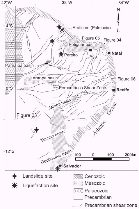
Figure 2: Simplified geological map of northeastern Brazil and location of main historical and recent liquefaction sites.
The history of seismicity and Neogene tectonic studies in northeastern Brazil dates back to the nineteenth century. Capanema (1859) was the first to describe accurately the seismicity in the region (Fig. 1). Because of the methods available at the time, his studies were based on the macroseismic reconstruction of seismicity. Seismological and Neogene studies were conducted in a systematic way from the XX century onwards. During the 1950s to the 1960s, these studies were dominated by a geomorphological approach mostly based on observations of a regional nature. The study of King (1956) in northeastern Brazil, for example, was based on planation surfaces in southeastern Brazil. These studies described planation surfaces that affected crustal blocks in areas as large as 100 km long and which could present flexures. Studies that included the foundations of plate tectonics started in the late 1970s. Sykes (1978) was one of the first to correlate intraplate seismicity with zones of weakness and magmatism. However, the turning point in both seismological and paleoseismological studies were the 1986- 1989 João Câmara earthquake swarm (Fig. 1). Today, these studies are concentrated in the Potiguar basin and its border, west of the Potiguar basin, and along the Pernambuco shear zone (Figs. 2 and 3).
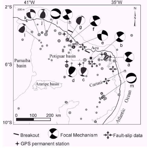
Figure 3: Focal mechanisms and location of permanent GPS stations in northeastern Brazil. Key to location and age of seismicity: a, João Câmara (1986-87); b, Açu Dam (1990-91); c, Augusto Severo (1990); d, Tabuleiro Grande (1993); e, Palhano (1989); f, Cascavel (1994); g, Cascavel (1989); h, Pacajus (1980); i, Irauçuba (1991); j, Irauçuba (1991); k, Senador Sá (1997), l, Groaíras (1988); m, Hidrolândia (1991); n, Caruaru (1991); o, Cariatá Graben.
In northeastern Brazil, judging from the historical and instrumental seismicity, surface rupture and liquefaction are unlikely anywhere in the region. No coseismic surface rupture has been reported for any of the historical or instrumental events (Ferreira et al. 1998). In addition, in many cases the seismic activity has no relation to faults mapped on the surface. But widespread evidence of coseismic surface rupture and liquefaction occur in the Neogene record. This incompatibility between present-day seismicity and Neogene data points to an important knowledge gap.
This review aims to provide an understanding of a rapidly moving field in a region previously considered to be tectonically "passive." In this study, we catalogued and evaluated the recent literature on the subject. This work represents the first review that deals specifically with northeastern Brazil and with the regional seismicity and Neogene tectonics, where available seismicity data was integrated in a Neogene context.
Studies on seismology and Neogene tectonics are increasingly common in Brazil. Our review owes much to our predecessors and contemporaries, from which point we depart. These previous reviews assessed the entire country and discussed seismicity (Branner 1912, 1920, Berrocal et al. 1984, Assumpção 1998), present-day stress fields (Assumpção 1992, Riccomini and Assumpção 1999), and neotectonics (Saadi 1993, Saadi et al. 2005). Other reviews took a regional approach. Previous reviews of the seismicity of Northeastern Brazil were presented by Ferreira and Assumpção (1983), and Ferreira et al. (1998). A careful examination of the Neogene tectonics along the coast of the State of Bahia was presented by Lima (2000).
As the literature on the subject is extensive, our review mainly relies on complete publications and unpublished theses in order to avoid redundancies and long discussions. We quote a few key conference reports, however. In the present work, we first present the historical and instrumental seismicity of the region. Subsequently, we discuss the present-day and Neogene stress fields. We describe the paleoseismic record by analyzing raised marine terraces and paleoliquefaction. We make an analysis of fault evidence derived from outcrops and borehole data, including deformation and deposition of main Neogene sedimentary units. Next we make a brief description of geodetic surveys under way. Finally, we discuss and conclude with remarks on the most important seismological and Neogene-tectonic findings and hypotheses.
HISTORICAL AND INSTRUMENTAL SEISMICITY
Historical data from the XVII to the XX century indicate that seismicity is not a new phenomenon in the region. These accounts relied on macroseismic data (effects of earthquakes on people, buildings, and nature). The first historical accounts related to seismicity in the region occurred in 1666 in the state of Bahia (Recôncavo area) and was possibly related to a tsunami. However, more precise description that included exact location and time occurred in 1725, also in the state of Bahia. Branner (1912, 1920) presented more precise macroseismic descriptions of earthquake swarms in the Salvador area (Fig. 2). In the northern part of the region, the first event occurred in 1808 in the Açu area (Figs. 1 and 3) and had an estimated 4.8 mb (magnitude of body waves) (Figs. 1 and 3). Ferreira (1983) and Berrocal et al. (1984) present a more complete description of these historical events. Several descriptions followed these accounts until the 1980s, when systematic instrumental monitoring started in the region. The instrumental seismicity in northeastern Brazil had its turning point on 5 August 1986, when a magnitude 3.0 struck the João Câmara area (see details below). This seismic activity, the largest ever recorded in Brazil, motivated instrumental studies in the region. Most of the instrumental seismicity recorded in the region so far occurred after 1986. Since then, seismicity has been detected by seismometer networks, which improved the station coverage dramatically. These networks are usually deployed after an event felt by the local population and usually detect aftershocks of an earthquake swarm.
The instrumental seismicity has a few general characteristics. First, the seismicity in the region occurs as earthquake swarms that may last several years. Second, earthquakes occur in the upper crust as deep as 12 km. Third, in most cases, earthquake swarm form oriented clusters. These clusters usually match one nodal plane deduced from focal mechanism.
The instrumental studies have revealed several areas of relatively high seismicity. South of 7º S no earthquakes with magnitude above 4.0 mb have occurred after 1920. North of 7º S, the instrumental seismicity is mostly concentrated around the Potiguar basin, in the crystalline basement between the Potiguar and Parnaíba basins, and along the Pernambuco shear zone (Fig. 3). The border of the Potiguar basin is currently one of the most tectonically active part of Brazil. For example, the largest earthquake that struck northeastern Brazil (5.2 mb) took place on its western border. Table 1 shows the distribution of the most important earthquakes swarms discussed below.
Table 1: Important earthquake swarms in northeastern Brazil (*).

João Câmara at the border of the Potiguar basin is by far the best-recorded earthquake sequence in Brazil (Figs. 1 and 3). It corresponds to more than 50,000 recorded events in 1986-94 and is confined to the upper 1- 12 km of the crust; 20 were mb 4.0, and two events were mb = 5.0. Previous activity occurred in 1950 (3.0 mb) and again in 1983 (2.2 mb).
The seismicity at João Câmara does not match geological features at the surface. Takeya et al. (1989) studied the 1986-89 earthquake swarm, and they found a clear NE-SW, ~ 1-2 km thick and 40 km long seismogenic fault that dips 70º to NW, called the Samambaia fault. This fault plane is consistent with the focal mechanism reported by Ferreira et al. (1987), which indicates a dextral strike-slip fault movement. The trend of the Samambaia fault (045º), however, is oblique to geological surface features such as Precambrian shear zones and foliation (Fig. 4).

Figure 4: João Câmara epicentral area: epicenter locations and simplified geological map (modified from Amaral 2000; epicenters after Takeya 1992).
The Açu reservoir is a well-known example of induced seismic activity. It formed NEtrending, well-defined elongated clusters that occurred after the dam impoundment. The orientation of epicenter clusters at the Açu reservoir coincides with the ductile Precambrian fabric (Fig. 5). Ferreira et al. (1995) and do Nascimento et al. (2004) interpreted the seismic activity at Açu as induced by the reservoir, which reactivated faults mapped in the area by Amaral (2000). Ferreira et al. (1995, 1998) and do Nascimento et al. (2004) also determined the focal mechanisms, which indicate dextral strike-slip fault movement.

Figure 5: Açu Dam epicentral area: epicenter locations and simplified geological map (geological map modified from Amaral 2000; epicenters after Ferreira et al. 1995 and Do Nascimento et al. 2004).
Other earthquake swarms struck the region. The swarm activity in the Palhano area occurred in an E-W-oriented, 5 km long, and roughly vertical cluster of epicenters. The orientation of epicenters cut across the NE-trending Precambrian shear zone in the area. The Palhano fault, derived by focal mechanisms, moves as a right-lateral strike slip fault (Fig. 3). The swarm activity in the Cascavel-Pacajus area formed three clusters of epicenters (Fig. 3). Ferreira et al. (1998) and Vilar (2000) observed no alignment of epicenters. But the focal mechanism solution indicates an E-Woriented, right-lateral fault plane (Fig. 3). The swarm activity at Caruaru occurred in 1991 immediately to the west of the city and coincided with the Precambrian Pernambuco shear zone (Fig. 6). The seismicity does not occur as an oriented cluster, but the focal-mechanism solution determined by Ferreira et al. (1998) indicates clearly an E-W-oriented, normal fault plane.
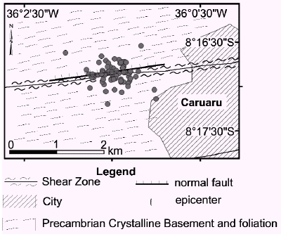
Figure 6: Caruaru epicentral area: epicenter locations and simplified geological map.
NEOGENE TO PRESENTDAY STRESS FIELD
Examination of the present-day stress field in NE Brazil indicates two patterns. The first is that the orientation of the maximum horizontal compression is not uniform. Second, the orientation of this compression roughly follows the coastline (Assumpção 1992, Lima et al. 1997, Ferreira et al. 1998). However, a few exceptions to this pattern occur in places (França et al. 2004).
The present-day stress field was derived from two sources: focal mechanism and breakout data. The focal mechanism data concentrate north of 7ºS (Fig. 3). Based on these data, Ferreira et al. (1998) showed that the vast majority of seismic activity is characterized by a strike-slip stress regime. Thus the maximum and minimum compressional stresses are horizontal. They also concluded that the strike-slip stress regime corresponds to a roughly E-W-trending horizontal compression.
Breakout data is concentrated along the coast, where the Cretaceous sedimentary basins occur. These data indicate that in the onshore part of the Potiguar and Ceará basins the maximum horizontal compression trends about E-W to ESE-WNW. Along the east coast, to the south of the study area along the Sergipe, Tucano, Recôncavo, and Camamu-Almeda basins, the maximum horizontal compression occurs from 09º to 15ºS latitude roughly parallel to the coastline. In the Alagoas basin, however, the maximum horizontal compression is 102º az (Fig. 3) (Lima et al. 1997).
The hypotheses that explain the presentday stress field take into account regional and local features. Ferreira et al. (1998) and Assumpção (1992) suggested that the regional stress field would be generated mainly by the ridge push and collisional boundary forces on the South American Plate. The local stress field would be generated by extensional stress caused by the density contrast between the continental and oceanic crust along the coast. They concluded that the stress pattern is the superposition of the E-W compressional stress regime with the local extensional stresses perpendicular to the coast.
Along the east coast, the directions of compression do not conform to the predictions by Meijer (1995) and Coblentz and Richardson (1996). According to Lima et al. (1997), this may be due to decoupling between tectonic stresses in the upper crust and those in the sedimentary basins. Alternatively, Lima et al. (1997) indicated that flexural forces that act along the continental margin were not taken into account by the predictions. According to Lima et al. (1997), the maximum-horizontal compression rotation along the coast of northeastern Brazil would be caused by flexural stresses from sediment load in the continental shelf.
Paleostress inversion analyses were carried out at two sites. Sousa and Bezerra (2005) described a Neogene stress field that affects the Barreiras Formation and younger alluvial deposits. In the Potiguar basin (Fig. 3), the Neogene stress field presents horizontal, E-W-oriented maximum compression and N-S-oriented maximum extension. The Neogene stress field generated strike-slip, NE-oriented dextral faults, NW-oriented sinistral faults, and E-W-oriented normal faults. In the Cariatá graben (Fig. 3), the maximum compression is horizontal and ENE, and the maximum horizontal extension is NNW-oriented. These stress tensor directions are roughly consistent with the present-day stress directions both further north in the Potiguar basin and further south at Caruaru area. These findings suggest a continuing stress field in the region during the Neogene.
UPLIFTED MARINE TERRACES
The use of marine terrace deposits to detect crustal movements is becoming increasingly common. The coastline is expected to respond not only to vertical but also to horizontal movements. The studies that use marine deposits along the littoral zone have been important for many reasons. First, sea level may be considered a relatively flat and horizontal datum in a regional scale, i.e., less than 200-300 km. Second, marine terrace deposits are rich in fossils and, thus, easy to date. Third, tectonic activity in the coastal zone may disturb the delicate balance among biological, chemical, and physical features and phenomena. This combination of factors may be used as an accurate tool for both temporal and spacial determinations.
Along the Brazilian coast, including northeastern Brazil, several marine terrace deposits were mapped and assigned an age according to a combination of geomorphologic, stratigraphic, and sometimes paleontologic features. The terraces were originally ascribed to the Tertiary period. Today, they are considered Quaternary and have been associated with Pleistocene interglacial and glacial cycles.
In Brazil, the use of marine terrace deposits for both eustatic and tectonic studies may be grouped into Holocene and Pleistocene deposits because of coastal fault slip-rates and age of the tectonic process.
The investigation of Holocene shorelines in northeastern Brazil has produced ambiguous results, which have indicated stable and uplifted/downfaulted marine terrace deposits. Martin et al. (1986) dated Holocene sea-level indicators along the coast of the Recôncavo area. The mismatch among the sea-level indicators and the Salvador curve, a Holocene sea-level curve proposed for the area, was regarded as evidence of coastal uplift and subsidence as high as 3 m. More recently, Martin et al. (2003) have regarded all the sea-level data along the Brazilian coast, including northeastern Brazil, as eustatic fluctuation. Bezerra et al. (1998) also used the mismatch between raised shorelines and a glacio-isotatic curve as evidence of tectonic vertical movements of 3-4 m along the coastal zone of the state of Rio Grande do Norte. A more recent study by Bezerra et al. (2003), however, concluded that in a mesotidal regime (tides up to 3 m high), such as that of northeastern Brazil, the height uncertainty range must include accuracy of sea-level indicators, and the error due to height measurements. Bezerra et al. (2003) noted that this height uncertainty was not taken into consideration by several studies, which gave a false sense of accuracy to several sea-level curves that claim to represent sea-level changes along the Brazilian coast. They concluded that the "noise" caused by these uncertainty problems should produce ambiguous patterns. They also suggested that faults that present offsets of more than 4-5 m may be seen in the sea-level record. Otherwise, faults that present vertical offsets of less than 2-3 m cannot be detected in the marine record if the height of deposit is the applied tool.
Barreto et al. (2002) identified marine terrace deposits that cap the Barreiras Formation along the coast of the states of Rio Grande do Norte (Fig. 7). These marine terrace deposits correspond to two sea-level highstands and oxygen-isotope stages: 7c (220-206 ka) and 5e (117-110 ka) (Chapell and Shackleton 1986). The 120 ka marine terrace deposits present the same age of marine terrace deposits dated in the Bahia littoral zone by Martin et al. (1982). The 210 ka marine terrace was the first to be dated along the Brazilian coast. The base of the 210 ka marine terrace deposits varies from 7.5 m to 1.3 m in elevation. The base of the 120 ka marine terrace deposit ranges in elevation from 1 m to 20 m. This altitude change is consistent with a scenario in which northeastern Brazil has been subjected to differential subsidence or uplift in the late Quaternary. These studies concluded that coastal uplift and subsidence up to 12 m occurred along the coast from the late Pleistocene until the present and that elevation alone is an unreliable tool for establishing marine terrace chronology.

Figure 7: Liquefaction sites and marine terrace deposit locations. Key: Abf, Afonso Bezerra fault; Cf, Carnaubais fault; Jf, Jundiaí fault.
PALEOLIQUEFACTION STRUCTURES
Evidence from seismic-induced liquefaction in the region comes from two sources: historical and present-day reports and field data. The threshold magnitude for liquefaction in sand is about 5.0 M, which has been observed in the region since 1808. The reports cited in Ferreira (1983) indicate that liquefaction occurred at least at two sites: during the Itaparica earthquake of 22 March 1911 (MMI VII, intensity VII in the Modified Mercaly Scale) and again during the Araticum earthquake swarm in March and April 1969 (Fig. 2). These events caused landslides, soil collapse, and localized subsidence.
Evidence from the geological data was described in Miocene and Pleistocene alluvial deposits. Saadi and Torquato (1992) described liquefaction features in alluvial gravels in the early and late Neogene that cap the crystalline basement between the Potiguar and Parnaíba basins. More recently, Bezerra and Vita-Finzi (2000) and Bezerra et al. (2005) described liquefaction features in late Pleistocene alluvial gravels and gravelly sediments in and close to the Potiguar basins (Fig. 7). These studies showed the occurrence of dikes, pillars, pockets, and convolute folds. Bezerra et al. (2005) suggested that the liquefaction features described in the region represent paleoseismicity consistent with estimated magnitude 6.8 M, based on threshold magnitude of liquefaction in gravel.
GEOLOGICAL DATA
Since Sykes (1978) suggested that intraplate earthquakes in northeastern Brazil are the result of reactivation of crustal zones of weakness, much has been done to understand the behavior of active and Neogene faults in the region.
There are clear examples of reactivated structures that have led to faulting in the Neogene and in the present day. These examples may or may not show present-day seismicity. At Caruaru, the Pernambuco shear zone was reactivated in the Cretaceous during the generation of the Jatobá basin. The focal mechanism indicates that the nodal fault plane coincides with the EW- trending Pernambuco shear zone. At the Açu reservoir area, epicenter alignments correlate with the Precambrian shear zones. Other examples of dormant fault that affect Neogene units occur in the geological record. This reactivation generated variations in the thickness of sedimentary deposits over the main bounding faults, as well as fault scarps, fault-line scarps, and fault-controlled drainage patterns. Silva (1991) concluded that normal faults deform deltaic and other coastal deposits as old as 30,190-2,340 yr BP in the Assu delta (Fig. 7). These faults are reactivated Cretaceous faults mapped in the area. The Carnaubais fault is a Precambrian structure that affects Neogene and Cretaceous deposits. This fault strikes 065º and offsets the base of the Barreiras Formation by about 60 m near the coast (Caldas et al., 1997). It also uplifts a marine bioclastic grainstone that interfingers with the Barreiras Formation southeast of the fault near São Bento (Bezerra and Vita-Finzi 2000) (Fig. 7). In addition, in the coastal area of the state of Rio Grande do Norte, normal and strike-slip NE (40-60º) and NW (300-320º) striking faults generated a graben-horst structure that produced the locally known Tabuleiros costeiros (coastal tablelands) formed by the Barreiras Formation (Bezerra et al. 2001). Several of these faults correspond to reactivated shear zones.
In many cases, however, the relationship among seismogenic and Neogene faults and known geological features is dubious. Three cases are presented. Takeya et al. (1989) ruled out any relationship between the seismogenic Samambaia fault and surface features. Despite early studies that presented no clear surface feature associated with the seismogenic fault, Sousa et al. (2005) presented evidence that quartz and chalcedony veins at the surface mark the trace of the Samambaia fault. This surface expression of the Samambaia fault is still a matter of debate.
The Jundiaí fault strikes 060º and cuts across the Precambrian fabric (Fig. 7). It offsets the base of the Barreiras Formation vertically by as much as ~ 260 m. Within the Jundiaí fault zone, sediment-filled fractures up to 30 m deep present crushed and striated pebbles and coarse sand to clay. An AMS 14C age yielded 4,860-4,570 yr BP on charcoal fragments in the fractures. These field data indicate an important Neogene activity (Bezerra and Vita-Finzi 2000).
The Cariatá graben is a ~ 20 km wide and ~ 50 km long, fault-controlled trough ~ 45 m deep. It is filled with debris flow and mud flow deposits of 22-45 and 128-209 ka, respectively (Brito Neves et al. 2004, Bezerra et al. 2005) (Fig. 3). One of the bounding faults is a reactivated Proterozoic shear zone. The other border cuts across the Precambrian fabric, however. These examples indicate that in many cases new and reactivation faults may coexist, or the nature of the reactivation process may even be questioned.
GPS SURVEYS
There is no geodetically determined crustal deformation in the region so far. In 2003, the UFRN Seismological Laboratory, member of the University Navstar Consortium (UNAVCO), began a scientific project with the primary goal of monitoring crustal deformation across the Potiguar basin using a GPS network. This project is driven by the fact that the region is one of the most seismically active locations in the Brazilian shield.
The network installed satisfies all criteria for advanced ground monitoring. It is composed of five continuously operating Global Positioning System receivers around the Potiguar basin (Fig. 3). The permanent GPS site establishment is equipped with a Trimble GPS system for high-precision geodetic purposes. Each permanent station is composed of dual frequency Trimble 5700 receivers. The network became fully operational in mid-2004.
The sites were selected to detect fault movements in seismic areas and ensure that the monuments would provide maximum stability. All sites presented instrumental seismicity in the last 20 years.
All sites also satisfy the GPS permanentstation criteria: clear 360º horizon above 10º elevation, and absence of any feature that may cause inference or multipath reflection. In addition, the sites were installed on crystalline-basement rocks (gneisses, migmatites, schists), which improve the stability of the monuments. Data analyses are under way.
DISCUSSION AND CONCLUSION
This work attempted to review seismological and Neogene evidence of tectonics in northeastern Brazil. A critical review of the main hypotheses and speculations about these findings is necessary.
The knowledge of the seismicity in the region increased dramatically after the João Câmara earthquake swarm in 1986. Since then, the increasingly detailed seismological data allowed a few conclusions. Seismic activity concentrates in the upper crust from 1 to 12 km. Earthquakes tend to occur to the north of 7ºS latitude, along the WNW-ESE-trending coast, with little activity along the N-S-trending coast. The seismicity distribution does not show a clear spatial correlation with Neogene faults, except for the Pernambuco shear zone and Açu dam areas. These seismological instrumental data, alongside breakout data, indicate that the stress fields in the region vary. In general, the present-day maximum horizontal stress (SHmax) roughly follows the coastline.
Despite these increasingly detailed seismological data, both the historical and the instrumental record for northeastern Brazil is too short to provide a realistic evaluation of the past (paleo) seismic activity. Therefore, the most reliable approach for a complete tectonic assessment in the region is one that includes paleoseismicity investigations. We decided to describe and evaluate the paleoseismic investigation in the Neogene because of the lack of reliable data to mark the onset of the neotectonic period in the region. This was motivated because the start of Neogene coincides with the Barreiras Formation deposition and the last pulses of volcanic activity in the region.
Several studies presented evidence of Neogene tectonic activity such as the displaced marine terrace deposits along the coast, liquefaction features in alluvial terraces, and faults that cut across both the crystalline basement and Neogene deposits. Field data show that the present-day tectonic activity is part of a deformation event that occurred during the Neogene.
The potential use of marine terrace deposits to identify coastal uplift and subsidence is immense and has been addressed in northeastern Brazil. The chronology and height of marine terrace deposits come from the studies of Bezerra et al. (2003), Suguio et al. (2001), and Barreto et al. (2002). The complexity of tectonic analysis of Holocene-raised shorelines is due to the small offset of Holocene faults (usually less than 2-3 m) and the relatively high noise caused by the mesotidal regime of more than 2 m in range. However, the analyses of late Pleistocene-raised shorelines show that coastal uplift and subsidence occur along the coast. These raised shorelines yielded ages that correlate with two marine highstands: 120 ka and 210 ka. They present offset of 10-12 m on a 300 km scale. But this chronology of marine terrace deposits investigated by these studies is difficult to correlate with other deposits along the Brazilian coast, owing to the lack of numerical dates.
Liquefaction in the Neogene deposits points to paleoearthquakes stronger than those observed both in the historical and instrumental records. The features are mostly pillars, dikes, pockets, and convolute folds. There is no reason to rule out earthquake as strong as 6.8-7.0 Ms in northeastern Brazil in the future despite the low recurrence rate of faulting.
Observations of Neogene crustal movements are still scattered. The major faults known to cut across Neogene deposits are mostly located along the coast in the Potiguar and Paraíba basins and in a few areas of the crystalline basement (Bezerra et al. 2001, 2005, Brito Neves et al. 2004). Precambrian shear zones and Cretaceous faults were reactivated in the Neogene. Coseismic faulting reactivations occurred along the Pernambuco and minor (less than 1 km wide) shear zones in the Açu-reservoir area. Other possible cases of reactivation have been reported in places such as the Samambaia fault (Bezerra and Vita- Finzi 2000). Despite the shallow depths of the Neogene fault described in the literature, clear correlation of any present-day seismicity or paleoseismicity with geological features have not yet been demonstrated in other areas.
The correlation between the present-day stress field and that observed in the Neogene has been made on the basis of fault-slip data. Sousa and Bezerra (2005) described the paleostress field in the Potiguar basin and concluded that a shift from a N-S-trending compression to the present-day ~ E-W-oriented compression occurred with the onset of the Barreiras Formation deposition in the beginning of the Neogene. However, local change in the stress field, not yet reported, could have occurred in the region.
The present-day stress field was explained as a combination of regional and local factors. Assumpção (1992) and Ferreira et al. (1998) proposed that the local stress field would be caused by density contrast between the oceanic and continental crust as well as flexural stresses, whereas the regional stress field would be ridge push or lithosphere drag related to the eastward movement of the South American Plate. Their elegant model would favor seismicity along the E-W-trending coast, where the observed compression and extension directions are consistent with the model. The seismicity would be less frequent along the N-Strending coast, where regional compression and local extension of these stress fields would compensate one another. Their model, however, does not explain why the seismicity concentrates along a relatively short segment of E-W to ESE-WSW-trending coast along the Potiguar and Ceará basins, and little seismicity is observed along the rest of the northern coast (Fig. 1). Other hypotheses have in common one point: the importance of previous faults in present-day seismicity and Neogene tectonics. The relationship among seismicity, geothermal flux, Cenozoic magmatism, and crustal zones of weaknesses was first proposed by Sykes (1978) and later by Carneiro et al. (1989). They have proposed that seismicity concentrates along zones of high to middle heat flow. Saadi and Torquato (1992) proposed a mega dextral shear system limited by two E-W-trending lineaments. The northern lineament would be a weakness zone roughly parallel to the coastline. The southern lineament would be the Patos shear zone, and the structure would be a lineament parallel to the present coastline. Torres (1994) proposed the same model, however limited by a sinistral shear system in the Potiguar basin. More recently, Bezerra and Vita-Finzi (2000) suggested that several of the NW- and NE-trending faults in the Potiguar basin area would be in optimum orientation for reactivation of the present-day E-W-oriented compression. These models lead us to conclude that the lithology and age of the Precambrian crust are not the most important controls of brittle reactivation. Rather, it is the stress field and the orientation of ductile fabric and Cretaceous faults that appear to influence Neogene faulting and seismicity.
However, a clear correlation between seismicity and Neogene faults is still pending. This calls for the integration of seismological, paleoseismological, and geodetic data. We suggest that more instrumental data are needed in order to understand the seismic stress field. Further paleoseismological studies are also necessary to decipher the seismogenic potential of the defined faults. In addition, the geodetic data being gathered are essential to quantify present-day slip rates and analyze the extent to which the present crustal movements occur in the form of aseismic creep or as stick-slip.
ACKNOWLEDGMENTS
We thank Marcelo Assumpção and Claudio Riccomini (Universidade de São Paulo, Brazil) for their helpful comments, which greatly improved the manuscript.
WORKS CITED IN THE TEXT
Almeida, F.F.M., Hasui, Y., Brito Neves, B.B. and Fuck, R.A. 1981. Brazilian structural provinces: an introduction. Earth Science Reviews 17: 1-29. [ Links ]
Amaral, C.A. 2000. Correlação entre contexto morfo-estrutural e sismicidade nas regiões de João Câmara e São Rafael (RN), unpublished MSc Thesis, Programa de Pós Graduação em Geodinâmica e Geofísica, Universidade Federal do Rio Grande do Norte, 80 p., Natal. [ Links ]
Assumpção, M. 1992. The regional intraplate stress field in South America. Journal of Geophysical Reseach 97: 11,889-11,903. [ Links ]
Assumpção, M. 1998. Seismicity and stress in the Brazilian passive margin. Bulletin of the Seismological Society of America, 88(1), 160-169. [ Links ]
Backer, A. 1993. An attempt to define a "neotectonic period" for central and northern Europe. Geologische Rundschau 82: 67-83. [ Links ]
Barreto, A.M.F., Bezerra, F.H.R., Suguio, K., Tatumi, S.H., Yee, M., Paiva, R.P. and Munita, C.S. 2002. Late Pleistocene marine terrace deposits in northeastern Brazil: sea-level change and Tectonic implications. Palaeogeography, Palaeoclimatology, Palaeoecology 179: 57-69. [ Links ]
Barreto, A.M.F., Suguio, K., Bezerra, F.H.R., Tatumi, S.H., Yee, M. and Giannini, P.C.F. 2004. Geologia e geomorfologia do Quaternário costeiro do Estado do Rio Grande do Norte. Geologia Universidade de São Paulo, série científica, São Paulo, 4(2): 1-12. [ Links ]
Berrocal, J., Assumpção, M., Antezana, R., Dias- Neto, C.M., Ortega, R., França, H. and Veloso, J.A. 1984. Sismicidade do Brasil. São Paulo, Brazil. Instituto Astronômico e Geofísico, Universidade de São Paulo, São Paulo, 320 p. [ Links ]
Bezerra, F.H.R. 2000. Neotectonic movements in northeastern Brazil: implications for a preliminary seismic hazard assessment. Revista Brasileira de Geociências 30(3): 562-564. [ Links ]
Bezerra, F.H.R., Amaral, R.F., Vita-Finzi, C., Lima-Filho, F.P. and Saadi, A. 2005. Liquefaction-induced structures in Quaternary alluvial gravels and gravelly sediments, NE Brazil. Engineering Geology 76: 191- 208. [ Links ]
Bezerra, F.H.R., Amaro, V.E., Vita-Finzi, C. and Saadi, A. 2001. Pliocene-Quaternary fault control of sedimentation and coastal plain morphology in NE Brazil. Journal of South American Earth Sciences 14: 61-75. [ Links ]
Bezerra, F.H.R., Barreto, A.M.F. and Suguio, K. 2003. Holocene sea-level history on the Rio Grande do Norte State coast, Brazil. Marine Geology 196: 73-89. [ Links ]
Bezerra, F.H.R., Lima-Filho, F.P., Amaral, R.F., Caldas, L.H.O. and Costa-Neto, L.X. 1998. Holocene Coastal tectonics in NE Brazil. In: Stewart, I. and Vita-Finzi, C. (Ed.): Coastal Tectonics. Geological Society of London, Special Publication 146: 279-293. [ Links ]
Bezerra, F.H.R. and Vita-Finzi, C. 2000. How active is a passive margin? Paleoseismicity in northeastern Brazil. Geology 28: 591-594. [ Links ]
Branner, J.C., 1912. Earthquakes in Brazil. Bulletin of the Seismological Society of America, 2: 105-117. [ Links ]
Branner, J.C. 1920. Recent earthquakes in Brazil. Bulletin of the Seismological Society of America 10: 90-104. [ Links ]
Brito Neves, B.B., Riccomini, C., Fernandes, T.M.G. and Santanna, L.G. 2004. O Sistema Tafrogênico terciário do Saliente Nordestino na Paraíba: um legado proterozóico. Revista Brasileira de Geociências 34(1): 127-134. [ Links ]
Caldas, L.H.O., Medeiros, W.E., Dantas, E.P., Sá, E.F.J. 1997. Caracterização geológica e geofísica de uma falha na borda leste do Graben de Umbuzeiro, Bacia Potiguar/RN, e suas implicações neotectônicas. Proceedings of the 5th Brazilian International Geophysical Congress 2: 885-888. [ Links ]
Capanema, G.S. 1859. Quaes as tradições, ou vestígios geológicos que nos levam a certeza de ter havido terremotos no Brasil. Revista do Instituto Histórico 22: 135-159, Rio de Janeiro. [ Links ]
Carneiro, C.D.R., Hamza, V.M. and Almeida, F.F.M. 1989. Ativação tectônica, fluxo geotérmico e sismicidade no Nordeste oriental brasileiro. Revista Brasileira de Geociências 19(3): 310-322. [ Links ]
Chappell, J. and Shackleton, N.J. 1986. Oxygen isotopes and sea level. Nature, 324: 137-140. [ Links ]
Coblentz, D.D. and Richardson, R.M. 1996. Analysis of the South America intraplate stress field. Journal of Geophysical Research 101: 8,643-8,657. [ Links ]
Crone, A.J., Machette, M.N. and Bowmam, J.R. 1997. Episodic nature of earthquake activity in stable continental regions revealed by palaeosiesmicity studies of Australia and North America Quaternary fault. Australian Journal of Earth Sciences 44: 203-214. [ Links ]
Do Nascimento, A.F., Cowie, P.A., Lunn, R.J. and Pearce, R.G. 2004. Spatio-temporal evolution of induced seismicity at the Açu reservoir, NE Brazil. Geophysical Journal International 158(3): 1041-1052. [ Links ]
Ferreira, J.M. 1983. Sismicidade do Nordeste do Brasil. MSC Thesis, Instituto Astronômico e Geofísico/Universidade de São Paulo, 192 p., São Paulo. [ Links ]
Ferreira, J.M. and Assumpção, M. 1983. Sismicidade no Nordeste do Brasil. Revista Brasileira de Geofísica 1: 67-88. [ Links ]
Ferreira, J.M., Oliveira, R.T., Assumpção, M., Moreira, J.A.M., Pearce, R.G. and Takeya, M.K. 1995. Correlation of seismicity and water level in the Açu reservoir - na example from Northeast Brazil. Bulletin of the Seismological Society of America 85: 1483- 1489. [ Links ]
Ferreira, J.M., Oliveira, R.T., Takeya, M.K. and Assumpção, M. 1998. Superposition of local and regional stresses in northeast Brazil: evidence from focal mechanisms around the Potiguar marginal basin. Geophysical Journal International 134: 341-355. [ Links ]
Ferreira, J.M., Takeya, M.K., Costa, J.M., Moreira, J.A.M., Assumpção, M., Veloso, J.A. and Pearce, R.G. 1987. A continuing intraplate earthquake sequence near João Câmara, northeastern Brazil - preliminary results. Geophysical Research Letters, 14: 1,042- 1,045. [ Links ]
França, G.S., Ferreira, J.M. and Takeya, M.K., 2004. Seismic activity in Senador Sá-CE, Brazil, 1997-1998. Brazilian Journal of Geophysics 22: 115-125. [ Links ]
Hasui, Y. 1990. Neotectônica e tectônica ressurgente no Brasil. In: 1º Workshop sobre Neotectônica e Sedimentação Continental Cenozóica no SE Brasil. Boletim da Sociedade Brasileira de Geologia-Núcleo Minas Gerais 11: 1-32, Belo Horizonte. [ Links ]
King, L.C. 1956. A geomorfologia do Brasil Oriental. Revista Brasileira de Geografia 2: 147-265. [ Links ]
Lima, C.C., Nascimento, E. and Assumpção, M. 1997. Stress orientation in Brazilian sedimentary basins from breakout analysis - implications for force models in the South American Plate. Geophysical Journal International 130: 112-124. [ Links ]
Lima, C.C.U. 2000. O Neotectonismo na costa do Sudeste e Nordeste Brasileiro. Revista de Ciência e Tecnologia, Universidade de Guarulhos 15: 91-102. [ Links ]
Martin, L., Bittencourt, A.C.S.P. and Vilas Boas, G.S. 1982. Primeira ocorrência de corais pleistocênicos da costa brasileira: datação do máximo da penúltima transgresssão. Ciências da Terra 3: 16-17. [ Links ]
Martin, L., Flexor, J.M., Bittencourt, A.C.S.P. and Dominguez, J.M.L. 1986. Neotectonic movements on a passive continental margin: Salvador region, Brazil. Neotectonics 1: 87-103. [ Links ]
Martin, L., Dominguez, J.M.L. and Bittencourt, A.C.S.P. 2003. Fluctuating Holocene sea levels in eastern and southeastern Brazil: Evidence from multiple fossil and geometric indicators. Journal of Coastal Research 19(1): 101-124. [ Links ]
McCalpin, J. 1996. Paleoseismology. Academic Press. 588 p., Estes Park. [ Links ]
Meijer, P.T. 1995. Dynamics of active continental margins: the Andes and Aegean region. Unpublished PhD thesis, Utrecht University, 218p. Utrecht. [ Links ]
Riccomini, C. and Assumpção, M. 1999. Quaternary tectonics in Brazil. Episodes 22(3): 221-225. [ Links ]
Saadi, A. 1993. Neotectônica da Plataforma Brasileira: esboço e interpretação preliminares. Geonomos 1(1): 1-15, Belo Horizonte. [ Links ]
Saadi, A. and Torquato, J.R. 1992. Contribuição à Neotectônica do Estado do Ceará. Revista de Geologia 5: 5-38, Fortaleza. [ Links ]
Saadi, A., Bezerra, F.H.R., Costa, R.D., Igreja, H.L.S. and Franzinelli, E. 2005. Neotectônica na Plataforma Brasileira. In: Souza, C.R.G., Suguio, K., Oliveira, A.M.S. and Oliveira, P.E. (eds.). Quaternário do Brasil. Holos Editora, 211-234, Ribeirão Preto. [ Links ]
Silva, C.G. 1991. Holocene Stratigraphy and evaluation of the Açu Delta, Rio Grande do Norte state, Northeastern Brazil. Unpublished PhD Thesis, Duke University, 348 p. Durham. [ Links ]
Slemmons, D.B. 1991. Introduction. In: Slemmons, D.B., Engdahl, E.R., Zoback, M.D. and Blackwell, D.D. (eds.) Neotectonics of North America. Geological Society of America 1-20. [ Links ]
Sousa, M.O.L. and Bezerra, F.H.R. 2005. As tensões tectônica campanianas-cenozóicas na Bacia Potiguar, Brasil. Extended Abstract. XXI Simpósio de Geologia do Nordeste. 329 p. [ Links ]
Suguio, K. and Nogueira, A.C.R. 1999. Revisão crítica dos conhecimentos geológicos sobre a Formação (ou Grupo) Barreiras do Neógeno e o seu possível significado como testemunho de alguns eventos geológicos mundiais. Geociências 18: 461-479. [ Links ]
Suguio, K., Barreto, A.M.F., Bezerra, F.H.R. 2001. Barra de Tabatinga and Touros Formations: evidence for Pleistocene high sea-level stillstands of the Rio Grande do Norte Coast. Revista Pesquisas em Geociências 28(2): 5-12, Porto Alegre. [ Links ]
Sykes, L.R. 1978. Intraplate seismicity, reactivation of preexisting zones of wekness, alkaline magmatism, and other tectonism postdating continental fragmentation. Reviews on Gephysics and Space Physics 16: 621-688. [ Links ]
Takeya, M.K. 1992. High precision studies of an intraplate earthquake sequence in northeast Brazil. Unpublished PhD thesis, University of Edinburgh, 228 p. Edinburgh. [ Links ]
Takeya, M.K.; Ferreira, J.M.; Pearce, R.G.; Assumpção, M.; Costa, J.M. and Sophia, C.M. 1989. The 1986-1989 intraplate earthquake sequence near João Câmara, northeastern Brazil - Evolution of seismicity. Tectonophysics 167: 117-131. [ Links ]
Torres, H.H.F., 1994. Metodologia para estudos neotectônicos regionais; o caso de João Câmara. Companhia de Pesquisa de Recursos Minerais. Série Publicações Especiais 2, 50 p. Recife. [ Links ]
Vilar, C.S. 2000. Estudo da Atividade sísmica em Cascavel-CE com estações sismográficas digitais. M.SC. Thesis, Programa de Pós-Graduação em Geodinâmica e Geofísica, Universidade Federal do Rio Grande do Norte, 73 p. Natal. [ Links ]
Recibido: 30 de junio, 2006
Aceptado: 15 de noviembre, 2006

