


Servicios Personalizados
Revista

Articulo
 Inglés (pdf)
 Articulo en XML
 Referencias del artículo
 Enviar articulo por email
Indicadores
-
 Citado por SciELO
Links relacionados
-
 Similares en
SciELO
Similares en
SciELO
Compartir

 Permalink
Revista de la Asociación Geológica Argentina
versión impresa ISSN 0004-4822versión On-line ISSN 1851-8249
Rev. Asoc. Geol. Argent. v.61 n.4 Buenos Aires oct./dic. 2006
Siame, L.L.1*, Sébrier, M.2, Bellier, O.1 and Bourles, D.1
1 Université Paul Cézanne (Aix-Marseille III) - CEREGE, Europôle de l'Arbois, B.P. 80, 13545 Aix-en-Provence Cedex 4, France
2 Université Pierre et Marie Curie, Laboratoire de Tectonique, 4 Place Jussieu, 75005 Paris, France
*Corresponding author e- mail: siame@cerege.fr
ABSTRACT
The build-up of in situ-produced cosmogenic 10Be within bedrock scarps and escarpments associated to the Cordillera Blanca Normal Fault, Peru, was measured to evaluate, through Cosmic Ray Exposure dating, its normal faulting activity. The highest mountain peaks in Peru belong to the 210 km-long, NW- striking, Cordillera Blanca. Along its western border, the Cordillera Blanca Normal Fault is responsible for a vertical relief over 4.4 km, whose prominent 2 km high escarpment is characterized by ~1 km-high triangular facets corresponding to vertical displacements cumulated during the last 1-2 million years. At a more detailed scale, this fault system exhibits continuous geomorphic evidence of repeated displacements, underlined by 2 to 70 m-high scarps, corresponding to vertical displacements cumulated since Late Pleistocene and Holocene periods. Although microseismicity occurs along the Cordillera Blanca Normal Fault, no major historical or instrumental earthquake has been recorded since the beginning of the Spanish settlement in the 16th century. To evaluate the vertical slip rate along the major 90 km-long central segment of the Cordillera Blanca Normal Fault, the Quaternary fault escarpment (i.e., triangular facet), as well as the bedrock fault scarp, have been sampled for 10Be Cosmic Ray Exposure dating. Even if the uppermost part of the triangular facets have been resurfaced by the Last Glacial Maximum glaciers, our results allow to estimate a vertical slip-rate of 3±1 mm/yr, and suggest at least 2 seismic events during the last 3000 years.
Keywords: Cosmic ray exposure dating; Fault escarpment; Cordillera Blanca.
RESUMEN
¿Dataciones por exposición de rayos cósmicos revelan fallamiento activo normal en la falla de la Cordillera Blanca, Perú? La acumulación in situ de 10Be cosmogénico en las rocas intrusivas de las escarpas de la falla normal de la Cordillera Blanca del Perú han sido medidas para evaluar, su actividad de fallamiento normal., con edades de exposición a los rayos cósmicos. Los más altos picos en el Perú conforman la Cordillera Blanca que se extiende con una longitud de 210 km según una orientación NO. A lo largo de su límite occidental, la falla normal de la Cordillera Blanca está asociada con un relieve que se encuentra por encima de los 4,4 km de altura y cuyo prominente escarpe de 2 km de elevación esta caracterizado por facetas triangulares de aproximadamente 1 Km. de elevación. Este escarpe de falla corresponde al desplazamiento vertical que se ha acumulado durante los últimos 1-2 millones de años. A una escala más detallada, este sistema de falla muestra evidencias geomorfológicas continuas de desplazamientos repetidos, sobrayados por escarpas de 2 a 70 metros de alturas, los cuales corresponden a los desplazamientos verticales acumulados durante el Pleistoceno tardío y el Holoceno. Aunque existe microsismicidad a lo largo de la falla normal de la Cordillera Blanca, no han sido registrados terremotos mayores históricos o mediante registro instrumental desde el inicio de la conquista española. Para evaluar, la tasa de deslizamiento vertical a lo largo del segmento mayor de la parte central de la falla normal de la Cordillera Blanca que tiene 90 kilómetros de longitud, se ha muestreado el escarpe cuaternario de la falla (i.e., faceta triangular) y la escarpa en el basamento para realizar edades mediante exposición a los rayos cósmicos con el isótopo 10Be. Aunque la parte más elevada de las facetas triangulares fueron retrabajadas por los glaciares del máximo de la última glaciación, nuestros resultados permiten estimar una tasa de deslizamiento vertical de aproximadamente 3 ± 1 mm/a y sugieren por lo menos dos eventos sísmicos durante los últimos 3000 años.
Palabras clave: Edades de exposición a los rayos cósmicos; Escarpa de falla; Cordillera Blanca.
INTRODUCTION
The Cordillera Blanca, which is the highest range in the Western Cordillera of Peru, is the most extensive tropical ice-capped mountain range in the world (Fig. 1). This region is well-known to scientists involved in natural hazard mitigation since local populations are frequently threatened by floods, glacial avalanches, or earthquakes. On May 31st 1970, a 7.7 magnitude earthquake occurred in the Peruvian subduction zone and shook the Cordillera Blanca range, triggering a huge glacial avalanche from the northern summit of the Huascarán. A few minutes after the earthquake, the 18,000 inhabitants of Yungay city perished, buried under 5 to 10 m of mud and enormous blocks. Such a glacial avalanche had already occurred in 1962 on the same area, devastating the village of Ranrahirca. Moreover, around Yungay city, old deposits of the same type, probably pre-Colombian in age, attest for the recurrence of such catastrophic events. In addition to the seismic risk associated to the geodynamical setting of South-America, the Cordillera Blanca range is bounded by the Cordillera Blanca Fault Zone, one of the most active faults in Peru (Macharé et al. 2003). This system has been reactivated by several earthquakes during the last thousands of years as suggested by the published paleoseismicity studies (Bonnot et al. 1988, Schwartz, 1988). Although no major seismic event has been associated to the Cordillera Blanca Normal Fault since the last 2000 yr (Silgado 1978, Schwartz 1988), this fault system is able to nucleate M 7-7.5 earthquakes (Schwartz 1988), enhancing natural hazard in the area. A major earthquake on the Cordillera Blanca Normal Fault would most probably trigger glacial avalanches and torrential floods along the Cordillera Blanca range, in addition to the damages caused directly by the earthquake shaking.
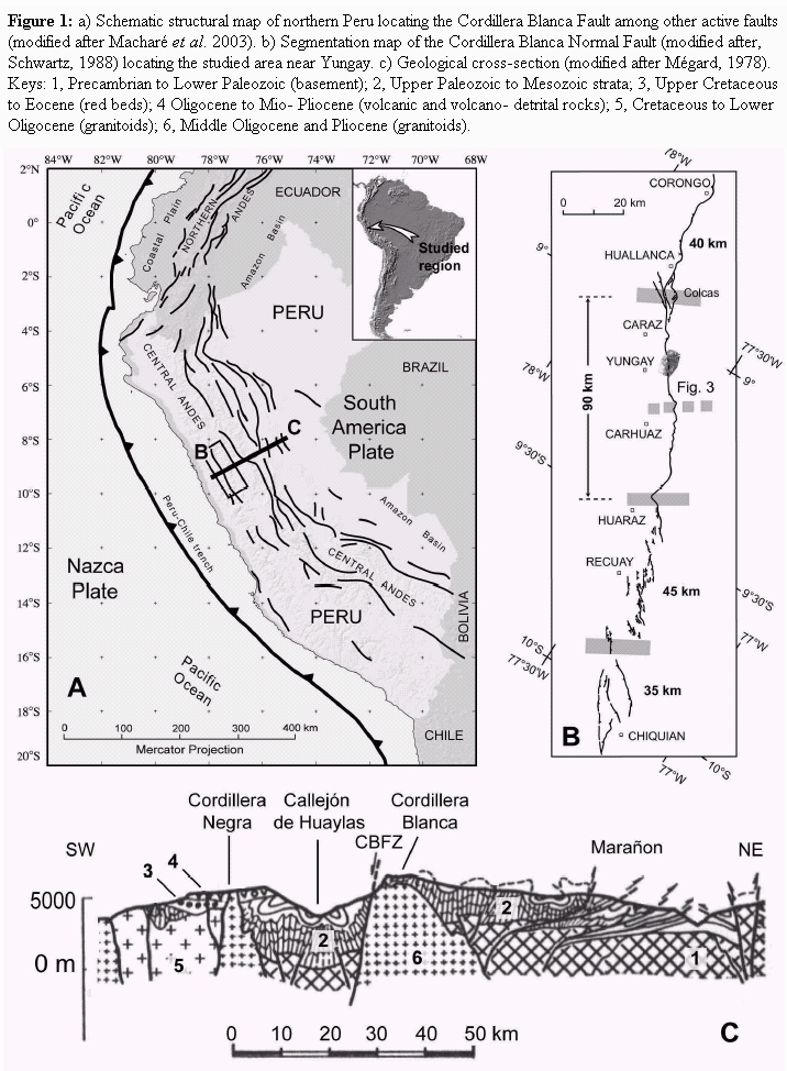
Figure 1: a) Schematic structural map of northern Peru locating the Cordillera Blanca Fault among other active faults (modified after Macharé et al. 2003). b) Segmentation map of the Cordillera Blanca Normal Fault (modified after, Schwartz, 1988) locating the studied area near Yungay. c) Geological cross-section (modified after Mégard, 1978). Keys: 1, Precambrian to Lower Paleozoic (basement); 2, Upper Paleozoic to Mesozoic strata; 3, Upper Cretaceous to Eocene (red beds); 4 Oligocene to Mio- Pliocene (volcanic and volcano- detrital rocks); 5, Cretaceous to Lower Oligocene (granitoids); 6, Middle Oligocene and Pliocene (granitoids).
Seismic hazard studies in several countries around the world increasingly rely upon identification and characterization of tectonically active geological structures. In such studies, one important step consists in determining long-term, integrated fault slip rates using offset geomorphic markers (e.g ., glacial moraines, fluvial and glacial terraces, alluvial fans, or drainage networks). Since the past decade, the development of dating methods using in situ-produced cosmogenic nuclides (e.g., Gosse and Phillips 2001) offers to Earth scientists the opportunity to better constrain rates of landscape evolution. Under favorable geomorphic conditions, such methods have been applied to active tectonic studies (e.g., among others, Ritz et al. 1995, Siame et al. 1997, Brown et al. 1998, Van der Woerd et al. 1998, Siame et al. 2002). In such studies, Cosmic Ray Exposure dating is used to place time controls on the emplacement and abandonment of passive geomorphic markers (alluvial fans and terraces) that are tectonically offset. When combined with the measurement of cumulative displacements, Cosmic Ray Exposure dating allows calculating long-term fault slip-rates, one of the key parameters used for seismic hazard assessments.
In this study, we examined the possibility to determine long-term slip rates associated with the Cordillera Blanca Normal Fault activity using Cosmic Ray Exposure dating of the fault morphology itself. Indeed, the interplay between the Cordillera Blanca range exhumation, due to the long-term Cordillera Blanca Normal Fault activity, and a series of Quaternary glacial valleys led to well-developed, ~1 km high, triangular facets. In addition, this fault system exhibits continuous geomorphic evidence of repeated displacements, underlined by 2 to 70 mhigh scarps that correspond to vertical displacements cumulated since Late Pleistocene and Holocene periods (Bonnot et al. 1988, Schwartz, 1988).We thus sampled the Quaternary fault escarpment (i.e., triangular facet) for 10Be Cosmic Ray Exposure dating to evaluate if this approach can reveal the long-term activity of the Cordillera Blanca fault. Up to now, only in situ-produced 36Cl surface exposure dating of exposed fault bedrock scarps in carbonated environments has allowed determining earthquake time-slip histories (e.g., Zreda and Noller 1998, Mitchell et al. 2001, Palumbo et al. 2004). In this study, we also sampled an exposed fault bedrock scarp to evaluate if 10Be cosmic ray exposure dating of the exposed crystalline rocks can help determining earthquake time-slip histories of the Cordillera Blanca fault.
GEODYNAMICS AND GEOLOGICAL SETTING
The NNW-striking Cordillera Blanca batholith is located between 9° and 11°S latitude with an average elevation over 4000 m, including the 6768 m-high Huascarán Peak. It belongs to the Western Cordillera of Peru (Fig. 1), which is the western part of the Andean High Plateau where was located the former Miocene magmatic arc. This Peruvian region is located above the North Peruvian flat slab segment (Cahill and Isacks 1992), characterized by an absence of volcanic activity since Pliocene times (Macharé, 1987). The Cordillera Blanca batholith is a ~200 km-long, granite and granodiorite elongated body that intruded roughly 8.2 Myr ago at ~3 kbar (McNulty et al. 1998) a sequence of Jurassic shales and sandstones. During its emplacement, the magma ascent was strongly controlled by periods of extension along the NNW-trending Cordillera Blanca Fault Zone (Petford and Atherton 1992). Fission track analyzes on apatite suggest that the average minimum uplift rate experienced by the Cordillera Blanca Fault Zone over the last 3 Myr should be on the order of 2 mm/yr (Garver et al. 1999). This active normal fault has been either regarded as a consequence of the compensated high Andean topography (Sébrier et al. 1988, Mercier et al. 1992) or, more recently, as a crustal detachment fault marking the juvenile phase of metamorphic core complex formation (McNulty and Farber 2002).
THE CORDILLERA BLANCA FAULT ZONE
This fault zone can be regarded as the most active fault of northern Peru (Macharé et al. 2003). It extends southward from Corongo to Chiquian, bounding the western flank of the Cordillera Blanca range in the intracordilleran basin of the Callejón de Huaylas (Bonnot et al. 1988, Schwartz 1988, Macharé et al. 2003). The Cordillera Blanca Normal Fault is roughly 210 km long, and strikes N145°E (Fig. 1). It dips roughly 40°W along much of its length, separating Miocene granite and granodiorite intruded within Mesozoic shales and sandstones in the footwall from Lower Pliocene tuff and Pliocene-Quaternary detritus in the hanging- wall (Fig. 1). It marks the boundary between the Cordillera Blanca range and the Callejón de Huaylas Basin which is filled by a ~2000 m thick, Pliocene continental sequence including basal tuff dated at about 5 Ma (Bonnot et al. 1988). Above the basal tuff, the Pliocene strata thicken and coarsen upward from fine-grained sediments to fanglomerates containing, toward the top, glacially-striated clasts. All together, those sedimentary characteristics indicate that the topography created by the Cordillera Blanca Normal Fault was already high enough by the Upper Pliocene to allow the development of a glacial environment. Above the Pliocene sequence, the Quaternary is mainly composed by a ~300 m thick sequence of glacial deposits and mass wasting dominated alluvial fans (Bonnot et al. 1988). From this detailed sedimentary study of the Plio-Quaternary strata that accumulated in the Callejón de Huaylas Basin, Bonnot et al. (1988) estimated that the Cordillera Blanca experienced at least 5 km of exhumation during the last 5 Myr, yielding a minimum, long-term uplift rate of about 1 mm/yr.
Though it exhibits continuous geomorphic evidence of repeated late Pleistocene and Holocene fault displacements (Schwartz 1988), the Cordillera Blanca Normal Fault has not experienced surface rupture in historic times since at least the early 1500s (Silgado 1978). Along its entire length, Pleistocene and Holocene fault scarps define the youthful trace and affect glacial moraines, glacial and post-glacial lacustrine and fluvial deposits, as well as alluvial fans and debris flows (Schwartz 1988). Near Colcas, pre-Inca irrigation walls are locally built up to and across the fault scarp of the Northern Cordillera Blanca. Using the relationships between those pre-Inca ruins, the fault, and debris flow deposits, Schwartz (1988) suggested that the walls were constructed relatively close in time to the most recent event, i.e., 1600-2200 years ago. On the basis of fault geometry and structural features, Schwartz (1988) proposed to subdivide the fault zone into four to possibly five major segments (Fig. 1). Generally, the fault trace is characterized by a main westfacing scarp running at the toe of the Quaternary fault escarpment, but graben features, back-tilted surfaces, and associated antithetic scarps can occur in zones a few tens to several hundred meters wide (Bonnot et al. 1988, Schwartz 1988). Those extensional features are particularly welldeveloped along the southern segments where the surface deformation is much more distributed than along the 120 km long fault trace north of Huaraz city (Fig. 1). Conversely, the 90 km long fault segment that extends from the bedrock salient located about 10 km north of Huaraz towards the Colcas ruins (Schwartz, 1988) is characterized by a single surface fault trace that correlates with both maximum icecapped peak elevation and relief (Fig. 2). Along this segment, the Cordillera Blanca Normal Fault is mostly expressed by a single and unique normal fault, which accommodated the total vertical movement that cumulated during Pliocene-Quaternary times. The interplay between range exhumation, due to the long-term Cordillera Blanca Normal Fault activity, and a series of Quaternary glacial valleys led to well developed, ~1 km high, triangular facets that result from the cumulated Quaternary deformation (Fig. 2). When compared to the other Cordillera Blanca Normal Fault segments, the vertical offsets recorded by the crests of Late Pleistocene glacial moraines (see hereafter) located along this fault segment also appear to be greater. Indeed, they are generally on the order of 30-40 m, with a maximum offset of about 60 ± 10 m (Bonnot et al. 1988). Conversely, the vertical offsets recorded by the crest of the late Pleistocene glacial moraines along the southern segment are only on the order of 12- 15 m (Schwartz 1988). Regarding these geomorphic characteristics, the 90 km long segment appears thus to be the most active one of the Cordillera Blanca Normal Fault.
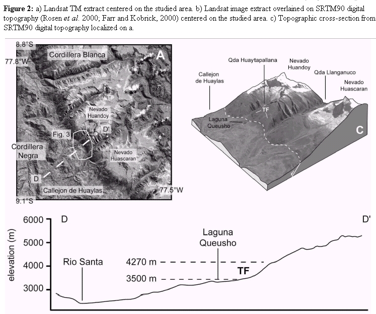
Figure 2: a) Landsat TM extract centered on the studied area. b) Landsat image extract overlained on SRTM90 digital topography (Rosen et al. 2000; Farr and Kobrick, 2000) centered on the studied area. c) Topographic cross-section from SRTM90 digital topography localized on a.
COSMIC RAY EXPOSURE DATING ON THE FAULT MORPHOLOGY ASSOCIATED TO THE HUARAZCOLCAS SEGMENT
Along the Huaraz-Colcas segment, the Cordillera Blanca Normal Fault is exposed as a spectacular, ~3 km high fault escarpment with ~1 km high triangular facets in its lower part. This escarpment most probably corresponds to the vertical displacement cumulated during the last 1-2 Myr (Fig. 2). As the fault activity exhumed the hanging-wall block with respect to the subsiding Callejón de Huaylas Basin, the granodiorite rocks have been exposed to the cosmic ray irradiation so that quartz minerals have been accumulating in situ-produced 10Be in their lattices. Theoretically, assuming negligible erosion, the cosmogenic nuclide built-up in the rocks that form the fault escarpment should thus increase with elevation, reflecting the fault activity through time.
GEOMORPHIC SETTING AT LAGUNA QUEUSHO
The studied area is located near Yungay (Fig. 3), at the toe of the Nevado Huandoy (6395 m). At Laguna Queusho (3480 m), the 900 m high triangular facets, situated between the Quebrada Huaytapallana to the north and the Quebrada Llanganuco to the south, have been selected because they appear to be among the best preserved (Figs. 2 and 3). Nevertheless, even though the planar, triangular shape of the facets is relatively well-preserved, the slope of the facets diminishes upward from ~40° at the basis to less than 30° close to its summit (Fig. 2). Moreover, detailed inspection of the slope morphology during fieldwork revealed that the outcropping granodioritic mylonite that arms the facet below ~4000 m has been scoured (roches moutonnées) and that unweathered, poorly consolidated, moraine deposits cover the slope of the facet above elevation higher than 4000 m. At Laguna Queusho, the local geomorphology also indicates imprints of glacial processes in the landscape. Indeed, at least 2 generations of moraines can be identified at the toe of the triangular facets (Fig. 3). The most conspicuous group consists of relatively well-preserved, steeply slopped, lateral moraines bounding the glacial valley of Quebrada Huaytapallana, perpendicularly to the western side of the Cordillera Blanca Range (Fig. 3). Another group consists of poorly preserved moraine arcs that are topographically more subdued. These moraines trend approximately northward, that is roughly parallel to the mountain range (Fig. 3). Geomorphic characteristics and relationships between the two families of moraines suggest that the well-preserved lateral moraines partly overlapped the subdued moraine arcs.

Figure 3::a) Schematic geomorphic map of Laguna Queusho area overlained on an aerial photograph extract (Servicio Aerofotográfico Nacional, 1962) locating the CRE samples: TF, triangular facet; LM, LGM lateral moraines; FM, early Late Glacial frontal moraines. b) Nevado Huandoy, 6354 m, Cordillera Blanca, Perú (Servicio Aerofotográfico Nacional, 1948). This aerial oblique view illustrates the geomorphic features detailed in the text: TF, triangular facet; LM, lateral moraine. The 60±10 m high, fault scarp running at the toe of the triangular facet is underlined by its own shadow. c and d) Field photographs showing the geomorphic features, and particularly the 60±10 m high, fault scarp running at the toe of the triangular facet associated to the Cordillera Blanca Normal Fault.
COSMIC RAY EXPOSURE DATING OF THE QUATERNARY TRIANGULAR FACETS
We sampled surface rocks from the triangular facets at various elevations using with hammer and chisel, and the location of each sample was recorded using a handled GPS device (Table 1). To account for the horizon shielding due to the surrounding topography, we integrated the functions described by Dunne et al. (1999) over the studied area, using an extract of the SRTM90 digital elevation model (Farr and Kobrick 2000). The measured 10Be concentrations have been converted to minimum surface exposure ages using a mean sea level, high latitude production rate of 5.1±0.3 atoms.g-1.yr-1, and using altitude, latitude-depend polynomials proposed by Stone (2000). The results are listed in Table 1.
Table 1: In situ-produced 10Be concentrations and minimum cosmic ray exposure ages of samples from the Cordillera Blanca Fault morphology. Measurements of 10Be were undertaken at the Tandétron AMS Facility at Gif-sur-Yvette, France (Raisbeck et al, 1987, 1994), using NIST 10Be standard (Standard Reference Material #43-25, 10Be/9Be = 2.68x10⁻¹¹, August 86). For each sample, the analytical uncertainty associated with the 10Be concentration results from uncertainties based on counting statistics (1s), conservative assumptions of 5% variability in Tandétron response, and a 50% uncertainty in the chemical blank corrections. The uncertainty on the minimum CRE ages includes the analytical uncertainty plus an assumed 15% error associated with variation through time of the modern, calibrate sea-level high latitude production rate value of 5.1±0.3 atoms 10Be/g quartz-year (Stone, 2000). *Elevation extracted from SRTM90 digital elevation model. **Shielding factors (horizon blockage by surrounding topography and slopes) are calculated according to Dunne et al. (1999) using SRTM90 data. ***Surface production rates are calculated using Stone (2000). # weigthed-means are calculated using  and
and  where xi and si are the CRE age and its absolute uncertainty for a sample i. The absolute uncertainty associated to the weighted-mean is given by

The glacially-polished rocks collected roughly 115 m above the basis of the facet have a minimum cosmic ray exposure age of 50.8±9.4 10Be-ka (PE96-004, 3613 m), whereas those located at higher elevations have lower minimum ages of 25.0±4.4 10Be- ka (PE96-005, 3724 m) and 19.8±3.7 10Beka (PE96-006, 3873 m). The weightedmean for this couple of samples is 22.5±2.9 10Be-ka (Table 1) and provides a good estimate for the exposure duration at the middle of the triangular facet. The glacial boulder samples collected at 4156 m, i.e., close to the summit of the facet, have minimum exposure ages of 13.9±2.3 10Be-ka (PE96- 008A) and 11.4±2.1 10Be-kyr (PE96-008B). These minimum exposure ages are in agreement with that calculated for a glaciallypolished bedrock sample (10.9±2.1 10Be-ka, PE96-007). The weighted-mean for this last triplet of samples is 12.2±1.3 10Be-ka (Table 1) and provides a good estimate for the exposure duration at the summit of the triangular facet.
COSMIC RAY EXPOSURE DATING OF THE BEDROCK FAULT PLANE
At the toe of the Quaternary fault escarpment, a main west-facing fault scarp cuts through the morphology (Fig. 3). Where the fault trace cuts the crests of the Quebrada Huaytapallana lateral moraines associated to the outreach of glacial valleys, the main fault scarp is associated to smaller, antithetic scarps producing graben-like zones a few tens meters wide (Bonnot et al. 1988). The vertical offset recorded by the crest of these lateral moraines is on the order of 60±10 m (Bonnot et al. 1988). From place to place, the fault plane itself is exposed as a ~40° west-dipping, planar surface cut into the granodioritic mylonite, offering the possibility to directly date the recent exposure of the fault plane (Table 1). The 10Be concentrations measured along the fault bedrock scarp are significantly lower than those measured in the rocks sampled along the fault escarpment, suggesting a younger tectonically-driven exposure history (Fig. 4). Nevertheless, excepting the lowermost sample, no 10Be built-up difference can be depicted between the samples, precluding any possibility to estimate a precise seismic recurrence. Indeed, those cosmic ray exposure data clearly indicate that nearly the whole mylonitic fault plane has been exposed roughly 3±1 10Be-kyr ago, most probably as the consequence of a large landslide event that may have been triggered by a destructive earthquake on the Cordillera Blanca Normal Fault. Interestingly, the sample collected at the toe of the fault plane shows a relatively young minimum cosmic ray exposure age of 708 ± 376 10Be-yr, suggesting that two different events (landslide and/or earthquake) are necessary to explain the ages on the fault plane (Fig. 4). These cosmic ray exposure ages fit both the regional historical seismicity (Silgado, 1978), which recorded no destructive earthquake on the Cordillera Blanca Normal Fault during the last 500 years, and the paleoseismological results (Schwartz, 1988), which indicate an average recurrence interval of 1000-3000 years during the last 15 kyr.

Figure 4: :Plot of the 10Be concentrations as a function of elevation, and their interpretation in terms of tectonic activity and glacial imprint on the landscape (wm: weighted-mean).
DISCUSSION AND CONCLUSIONS
First, the minimum cosmic ray exposure ages, calculated for the glacially-polished rocks collected from the faceted slope, should be discussed in the light of the regional glacial chronology. Along the western border of the Cordillera Blanca, Claperton (1972, 1983) identified three Pleistocene moraine groups and concluded that the ubiquitous, relatively well-preserved lateral and terminal moraines were deposited during the last glacial maximum. Further south, Rodbell (1993) estimated that the frontal ice-tongue reached the confluence between the Río Negro and the Quebrada Rurec more than 18 14C-ka BP. In the same area, in situ-produced 10Be dates for the younger moraines indicate that the end of the last glacial cycle comprised two separate advances at ca. 29 ka and ca. 16.5 ka (Farber et al. 2005). Furthermore, in the Cordillera Vilcanota-Quelcaya ice cap region (Southern Peru), the moraines deposited during the last glacial maximum are bracketed by maximum limiting radiocarbon ages of ca. 28.6 and 31.2 ka, and by a minimum limiting age of ca. 14 ka (Mercer and Palacios, 1977). The glacially-polished rocks (PE96-05 and PE96-06) that we sampled on the triangular facet at Queusho have minimum cosmic ray exposure ages that are in relative agreement with the regional time interval for the last glacial maximum lateral moraines. In striking contrast, the sample PE96-04 provides a cosmic ray exposure age that is significantly older. This suggests that the erosional processes that occurred during the end of the last glacial cycle did not reshape the faceted slope down-to the toe of the escarpment, allowing the preservation of the glacially-polished rocks dated at 50.8±9.4 10Be-kyr. In this framework, the lateral moraines bounding the Quebrada Huaytapallana glacial valley are most probably associated to one of the glacial advances at ca. 29 ka and ca. 16.5 ka (e.g., Farber et al. 2005) whereas the subdued moraine arcs may be considered as remnants of frontal moraines associated to an older Late Pleistocene glacial advance on the slope of the Cordillera Blanca.
Even though Cosmic Ray Exposure dating on the faceted slope reflect in first order the glacial imprint on the landscape during the last 60 kyr, some lines of tectonic implications can be drawn, using two end member hypotheses. The first one considers that the current topographic position (115 ± 20 m above the toe of the fault escarpment) of the glacially-polished rocks dated at 51 ± 9 ka is about the same that they occupied when they have been set at the surface by deglaciation. In such a case, the vertical rate associated to the Cordillera Blanca Normal Fault should be close to zero. This hypothesis is not consistent with the vertical offsets recorded by the crests of the last glacial maximum lateral moraines. Moreover, the well-preserved fault scarps running at the toe of the facet demonstrate that fault activity has been occurring during the last 30 ka. The second hypothesis considers that these glacially-polished rocks have cumulated roughly 115 ± 20 m of vertical displacement during the last 51±9 ka, suggesting a maximum vertical slip rate of 2.4 ± 0.8 mm/yr. This is a vertical rate that assumes only dip slip movement. Even if Bonnot et al. (1988) demonstrated that there has been a consistent sinistral component to the Quaternary slip, the amount must be small because lateral offsets of the steeply slopped, lateral moraine is not observed at the outreach of the Quebrada Huaytapallana (Fig. 3). On the other hand, if these lateral moraines are associated to the last glacial cycle (between 29 and 16.5 ka), the 60 ± 10 m vertical offsets cumulated by the moraine crests imply a vertical slip rate on the order of 2.98 ± 1.26 mm/yr, which is in good agreement with the vertical slip rate estimated above. This values are thus probably representative of the vertical slip rate associated to the Huaraz-Colcas segment.
Further south, at Quebradas Cojup and Llaca, glacial moraines dated at ~19 kyr using cosmic ray exposure 10Be are cut by a series of fault traces and exhibit a vertical offset of 25-35 m, and thus suggest an average vertical offset of 1.3-1.8 mm/yr (Farber et al. 2000). At Quebrada Queroccocha, thanks to geomorphic and trench studies, Schwartz (1988) estimated that the slip rate should be on the order of 0.9-1.4 mm/yr for the past 11-14 kyr. When compared with these previous studies, the cosmic ray exposure results obtained for the Huaraz-Colcas segment support the idea that the studied Cordillera Blanca Normal Fault segment may have been approximately two times faster than the end segments of the fault zone.
ACKNOWLEDGEMENTS
We thank the Peruvian Geophysical Institute for fieldwork support, IFEA (Institut Français des Etudes Andes) for travel grants and DRM (Délégation Risques Majeurs, presently MEDD) that fund part of the Peruvian project. Tandétron operation is supported by the CNRS, CEA and IN2P3. Funding for the analyses was partly provided by the PROSE program (INSUCNRS). We thank G.M. Raisbeck and F. Yiou for the AMS developments at the Tandétron of Gif-sur-Yvette, France, as well as J. Lestringuez and D. Deboffle for their expertise in AMS measurements. The authors also thank R. Basili and A. Lavenu for reviewing the manuscript.
WORKS CITED IN THE TEXT
Bonnot, D., Sébrier, M., and Mercier, J. 1988. Evolution géodynamique Plio-quaternaire du bassin intra-cordillerien du Callejon de Huaylas et de la Cordillère Blanche, Pérou. Géodynamique 3: 57-83. [ Links ]
Brown, E.T., Bourlès, D.L., Burchfiel, B.C., Oidong, D., Jun, L., Molnar, P., Raisbeck, G.M. and Yiou, F. 1998. Estimation of slip rates in the southern Tien Shan using cosmic ray exposure dates of abandoned alluvial fans. Geological Society of America, Bulletin 110 (3): 377-386. [ Links ]
Cahill, T. and Isacks, B. 1992. Seismicity and shape of the subducted Nazca plate. Journal of Geophysical Research 97: 17503-17529. [ Links ]
Clapperton, C. M. 1972. The Pleistocene moraine stages of west-central Peru. Journal of Glaciology 11: 255-263. [ Links ]
Clapperton, C. M. 1983. The glaciation of the Andes. Quaternary Science Reviews 2: 83- 155. [ Links ]
Dunne, J., Elmore, D. and Muzikar, P. 1999. Scaling factors for the rates of production of cosmogenic nuclides for geometric shielding and attenuation at depth on sloped surfaces. Geomorphology 27: 3-11. [ Links ]
Farber, D., Hancock, G., Finkel, R., Gallagher, S. and Palacios, O. 2000. The Kinematics of Continental Detachment Faulting: Slip rates along the Cordillera Blanca Detachment fault deduced from in situ produced Cosmogenic Radionuclides 10Be and 26Al. Eos, Transactions, American Geophysical Union 81 (48) F35. [ Links ]
Farber, D.L., Hancock, G.S., Finkel, R.C. and Rodbell, D.T. 2005. The age and extent of tropical glaciation in the Cordillera Blanca, Peru. Journal of Quaternary Science 20 (7-8): 759-776. [ Links ]
Farr, T.G. and Kobrick, M. 2000. Shuttle Radar Topography Mission produces a wealth of data: Amererican Geophysical Union, Eos 81: 583-585. [ Links ]
Garver, J.I., Brandon, M.T., Roden-Tice, M., and Kamp, P.J.J. 1999. Exhumation history of orogenic highlands determined by detrital Fission track thermochonology. Geological Society, Special Publication 154: 283-304, London. [ Links ]
Gosse, J.C., and Phillips, F.M. 2001. Terrestrial in situ cosmogenic nuclides: theory and applications. Quaternary Science Reviews 20(14): 1475-1560. [ Links ]
Macharé, J. 1987. La marge continentale du Pérou: régimes tectoniques et sédimentaires cénozoiques de l'avant-arc des Andes Centrales. Thèse Université de Paris XIOrsay, 391 p. [ Links ]
Macharé, J. Fenton, C.H., Machette, M.N, Lavenu, A., Costa, C. and Dart, 2003. Map and Database of Quaternary Faults and Folds in Peru ans its offshore regions: U.S. Geological Survey Open-File Report 03- 0451, 54 p., 1 plate (1:3,000,000 scale). [ Links ]
McNulty, B. and Farber, D. 2002. Active detachment faulting above the Peruvian flat slab. Geology 30: 567-570. [ Links ]
McNulty, B.A., Farber, D.L., Wallace, G.S., Lopez, R. and Palacios, O. 1998. Role of plate kinematics and plate-slip-vector partitioning in continental magmatic arcs: Evidence from the Cordillera Blanca, Peru. Geology 26(9): 827-830. [ Links ]
Mercer, J. H. and Palacios, O. 1977. Radiocarbon dating of the last glaciation in Peru. Geology 5: 600-604. [ Links ]
Mercier, J.L., Sébrier, M., Lavenu, A., Cabrera, J., Bellier, O., Dumont, J.-L., and Macharé, J. 1992. Changes in the tectonic regime above a subduction zone of Andean type: The Andes of Peru and Bolivia during the Pliocene-Pleistocene. Journal of Geophysical Research 97: 11945-11982. [ Links ]
Mitchell, S.G., Matmon, A., Bierman, P.R., Enzel, Y., Caffee, M. and Rizzo, D. 2001. Displacement history of a limestone normal fault scarp, northern Israel, from cosmogenic 36Cl. Journal of Geophysical Research 106 (B3): 4247-4264. [ Links ]
Palumbo, L., Benedetti L., Bourlès D., Cinque, A., and Finkel, R. 2004. Slip history of the Magnola fault (Apennines, Central Italy) from 36Cl surface exposure dating: evidence for strong earthquakes over the Holocene. Earth and Planetary Science Letters 225 (1- 2): 163-176. [ Links ]
Petford, N. and Atherton, M.P. 1992. Granitoid emplacement and deformation along a major crustal lineament: The Cordillera Blanca, Peru. Tectonophysics 205: 171-185. [ Links ]
Raisbeck, G.M., Yiou, F., Bourlès, D.L., Brown, E.T., Deboffle, D., Jouhanneau, P., Lestringuez, J., and Zhou, Q. 1994. Measurements of 10Be and 26Al with a Tandetron AMS facility at Gif-sur-Yvette: Progress, perturbations and projects. Nuclear Instrument Methods Physics Research B92: 43-46. [ Links ]
Raisbeck, G.M., Yiou, F., Bourlès, D.L., Lestringuez, J., and Deboffle, D. 1987. Measurements of 10Be and 26Al with a Tandetron AMS facility at Gif-sur-Yvette. Nuclear Instrument Methods Physics Research B29: 22-26. [ Links ]
Ritz, J.F., Brown, E.T., Bourlès, D.L., Philip, H., Schlupp, A., Raisbeck, G.M., Yiou, F., and Enkhtuvshin, B. 1995. Slip rates along active faults estimated with cosmic-ray-exposure dates: Application to the Bogd fault, Gobi- Altaï, Mongolia. Geology 23: 1019-1022. [ Links ]
Rodbell, D.T. 1993. Subdivision of late Pleistocene moraines in the Cordillera Blanca, Peru, based on rock-weathering features, soils, and radiocarbon dates. Quaternary Research 39: 133-143. [ Links ]
Rosen, P.A., Hensley, S., Joughin, I.R., Li, F.K., Madsen, S.N., Rodriguez, E., and Goldstein, R.M. 2000. Synthetic aperture radar interferometry. Proceedings IEEE 88: 333-382. [ Links ]
Schwartz, D.P. 1988., Paleoseismicity and Neotectonics of the Cordillera Blanca Fault Zone, Northern Peruvian Andes. Journal of Geophysical Research 93 (B5): 4712-4730. [ Links ]
Sébrier, M., Lavenu, A., Fornari, M., and Soulas, J.-P. 1988. Tectonics and uplift in central Andes (Peru, Bolivia, and northern Chile) from Eocene to present. Geodynamique 3: 85-106. [ Links ]
Siame, L.L., Bellier, O., Sébrier, M., Bourlès, D. L., Leturmy, P., Perez M., and Araujo, M. 2002. Seismic hazard reappraisal from combined structural geology, geomorphology and cosmic ray exposure dating analyses: the Eastern Precordillera thrust system (NW Argentina). Geophysical Journal International 150: 241-260. [ Links ]
Siame, L.L., Sébrier, M., Bellier, O., Bourlès, D.L., Castano, J.-C, and Araujo M. 1997. Cosmogenic dating ranging from 20 to 700 ka of a series of alluvial fan surfaces affected by the El Tigre Fault, Argentina. Geology 25: 975-978. [ Links ]
Silgado, E. 1978. Historia de los Sismos más Notables Ocurridos en el Perú (1513-1974): Instituto de Geología y Minería, Boletín 3 (Serie C, Geodinámica e Ingeniería Geológica) 129 p., Lima. [ Links ]
Stone, J.O. 2000. Air pressure and cosmogenic isotope production. Journal of Geophysical Research 105: 23 753-23 759. [ Links ]
Van der Woerd, J., Ryerson, F.J., Tapponnier, P., Gaudemer, Y., Finkel, R., Meriaux, A.S., Caffee, M., Guaguang, Z. and Qunlu, H. 1998, Holocene left-slip rate determined by cosmogenic surface dating on the Xidatan segment of the Kunlun fault (Qinghai, China). Geology 26(8): 695-698. [ Links ]
Zreda, M. and Noller, J.S. 1998, Ages of prehistoric earthquakes revealed by cosmogenic chlorine-36 in a bedrock fault scarp at Hebgen Lake. Science 292: 1097-1099. [ Links ]
Recibido: 30 de junio, 2006
Aceptado: 15 de noviembre, 2006

