


Services on Demand
Journal

Article
 English (pdf)
 Article in xml format
 Article references
 Send this article by e-mail
Indicators
-
 Cited by SciELO
Related links
-
 Similars in
SciELO
Similars in
SciELO
Share

 Permalink
Revista de la Asociación Geológica Argentina
Print version ISSN 0004-4822On-line version ISSN 1851-8249
Rev. Asoc. Geol. Argent. vol.62 no.4 Buenos Aires Oct./Dec. 2007
Gravimetry and GPS observations at Belgrano II station to test ocean tidal models
Scheinert, M.1, Zakrajsek, A.F.2, Eberlein, L.1, Marenssi, S.A.2, Ghidella, M.2, Dietrich, R.1 and Rülke, A.1
1 Technische Universität Dresden, Institut für Planetare Geodäsie, 01062 Dresden, Germany E-mail: scheinert@ipg.geo.tu-dresden.de
2 Dirección Nacional del Antártico, Instituto Antártico Argentino, Cerrito 1248, (C1010AAZ) Buenos Aires, Argentina
ABSTRACT
In the framework of a joint Argentine-German project gravimetric time series observations are being carried out at the Argentine Antarctic station Belgrano II. Two gravity meters were installed in the first half of February 2007. The set-up of the gravimeters as well as first results of the ongoing observations are discussed. Additionally, kinematic positions derived from a GPS-station at the Vahsel Bay glacier near Belgrano II can be used to get a first insight into the floating behavior of this glacier.
The goal of these observations is to discriminate the effect of ocean tides and to test ocean tidal models. Since ocean tides are an important phenomenon that has to be considered in a variety of geoscientific investigations in polar regions, appropriate corrections have to be applied in the different analyses, e.g. to infer temporal mass variations from satellite data, to investigate ice-shelf dynamics and deformations, or to come up with precise station positions and velocities within a terrestrial reference system. However, the ocean tide models show larger uncertainties in the Antarctic seas and (moreover) at areas covered by ice shelves and, therefore, need to be improved. This joint Argentine-German project is a contribution to the International Polar Year 2007/2008 and its project POLENET. After completion of the recordings at Belgrano II by the end of 2007 it is planned to move the equipment to San Mart ín in order to get a second gravimetric time series during the year 2008.
Keywords: Gravimetry. GPS. Ocean-tides models. Antarctica
RESUMEN
Observaciones gravimètricas y de GPS en la base Belgrano II para probar modelos de mareas oceánicas. En el marco de un proyecto conjunto germano-argentino se están obteniendo registros gravimétricos en la base antártica argentina Belgrano II, mediante dos gravímetros instalados durante la primera mitad de febrero de 2007. Se describen la puesta en marcha del sistema y los primeros resultados obtenidos de las observaciones en curso. Además, posiciones cinemáticas obtenidas mediante una estación GPS emplazada sobre el glaciar de la bahía Vahsel, en un sitio próximo a Belgrano II, pueden ser utilizadas para lograr una primera incursión en el comportamiento flotante del glaciar. La meta de estas observaciones es discriminar el efecto de las mareas oceánicas y poner a prueba los modelos de estas últimas. Siendo que los mareas oceánicas constituyen un importante fenómeno que debe ser considerado por una variedad de investigaciones geocientíficas en regiones polares, se hace necesario aplicar correcciones apropiadas en los distintos análisis, p.ej. para inferir variaciones transitorias de masa a partir de datos de satélite, para investigar la dinámica y deformaciones de barreras de hielo, o para obtener coordenadas y velocidades precisas dentro de un sistema de referencia terrestre. Sin embargo, los modelos de marea oceánica exhiben mayores incertidumbres en los mares antárticos y (más aún) en áreas cubiertas por barreras de hielo, necesitando ser, por consiguiente, mejorados. Tras completar los registros en Belgrano II hacia fines de 2007 se prevé desplazar el equipamiento a la base San Martín para obtener allí una segunda serie de registros gravimétricos durante el año 2008.
Palabras clave: Gravimetría. GPS. Modelos de mareas oceánicas. Antártida.
INTRODUCTION
The IPY project POLENET
One of the major goals of the International Polar Year 2007/ 2008 (IPY), which has been started on 01 March 2007, is to collect "a broad range of measurements that provide a snapshot in time of the state of the polar regions" and "to improve our understanding of global processes in these important areas" (www.ipy.org). With regard to geodesy and geophysics the IPY project 185 "Polar Earth Observing Network" (POLENET) pursues exactly this goal with aiming on deploying autonomous observatories at remote polar sites including GPS, seismics, gravity and tide gauges. Closing observational gaps in polar regions POLENET will substantially help to investigate polar geodynamics and to gain deeper insight into the interactions between cryosphere, solid earth, oceans and atmosphere. Within this framework, tidal gravimetry is one technique contributing to the goals of POLENET. Tidal gravimetry through its observations provides a connection between the aforementioned spheres. Sensing the tides of the solid earth as the main contribution, gravimetric time series observations are sensitive to ocean loading, to ice mass changes and the visco-elastic reaction of the earth linked to these as well as to atmospheric mass changes and loading. Thus, the joint Argentine-German project carrying out gravimetric time series observations at Argentine Antarctic stations is a valuable contribution to the goals of POLENET.
Utilization of ocean tide models for Antarctica
While solid earth tides can be observed, modelled and applied to yield appropriate corrections with sufficient accuracy, the treatment of the ocean tide impact largely depends on the reliability and accuracy of the ocean tide model in the area of investigation. Ocean tides have to be considered for the separation of ice mass changes and oceanic mass transport in Antarctica using temporal mass variations inferred from the Gravity Recovery and Climate Experiment (GRACE) mission (Horwath and Dietrich 2006), for the investigation of ice-shelf dynamics and deformation (Horwath et al. 2006), for the determination of precise offshore heights and height changes using dedicated satellite missions like ICESat and CryoSat (Padman and Fricker 2005), and to infer station positions and velocities from Global Navigation Satellite System (GNSS) observations in the frame of a precise and reliable terrestrial reference frame (Dietrich et al. 2005, Steigenberger et al. 2006). In Antarctica, satellite altimetry - due to the limited latitude range - may only partly or not at all contribute to the determination of ocean tide models. In situ data have to be collected in order to improve the models. Extended regions of poorly known ocean tides still exist especially in Antarctica with its large ice shelves. King et al. (2005) and King and Padman (2005) carried out a validation and assessment of ocean tide models around Antarctica. Using a point positioning strategy (King and Aoki 2003) it was demonstrated how GPS offshore data can be used to test ocean tide models. GNSS turned out to be feasible to overcome limitations of other techniques like coastal tide gauges or bottom pressure gauges, which cannot be deployed at regions with ice shelves or heavy sea ice coverage like the Filchner-Ronne Ice Shelf (FRIS) and the Weddell Sea, or the Ross Ice Shelf (RIS) and the Ross Sea. Tidal gravimetry is a further technique to be applied in ocean tide investigations, which has been discussed in detail for instance by Melchior and Francis (1996). For an overview of tidal gravimetric stations in Antarctica see figure 1. However, most Antarctic stations with long-term tidal gravimetry observations were located far from the large ice shelves, like Amundsen-Scott (Bos et al. 2000) or Syowa (Sato et al. 1997). Nevertheless, Global Navigation Satellite System and gravimetry provide independent data to test ocean tide models through a comparison with the respective load tide vector. For instance, gravimetry may give better estimates for the K1 and K2 constituents, which are systematically biased in GPS observations (King et al. 2005). These authors also showed that discrepancies between different ocean tide models are largest for the semidiurnal constituents (M2, S2) for Filchner-Ronne Ice Shelf, and for the diurnal constituents (O1, K1) for Ross Ice Shelf.
Figure 1: Tidal gravimetry stations in the Antarctic held in the database of the International Centre of Earth Tides (www.astro.oma.be/ICET). Locations of Belgrano II and San Martín are denoted by yellow squares.

GEODETIC TIDE OBSERVATIONS AT BELGRANO II STATION
A priori considerations
Both Belgrano II station as well as San Martín station are situated at a geographic position that allows them to test and improve ocean tide models carrying out gravimetric time series observations. Therefore, a joint Argentine-German project was initiated to record gravimetric time series at those stations. Project partners are Dirección Nacional del Antártico, Instituto Antártico Argentino (IAA) and Technical University of Dresden (TUD).
During 2007, the observations are being carried out at Belgrano II station. An overview of the area of investigation is given in Fig. 2, where an ASTER image (acquisition time 2006-01-16) is used in the background showing the ice surface topography. Belgrano II is situated on top of Bertrab Nunatak at the southern bank of Vahsel Bay in the south-eastern part of the Weddell Sea (see also Fig. 1). Vahsel Bay is covered by a glacier moving in north-west direction. From a preliminary analysis of a pair of ASTER images covering a time span of one year we inferred a flow velocity in the range 150 to 200 m/yr. Comparing the coastline given by the ASTER image with that given by the ADD 4.0 (blue line), the largest offset is visible in the area of the Vahsel Bay for the edge of the glacier flowing into the Weddell Sea. A rough estimation of this offset yields a value of about 3.5 km. The time of surveying of the coastline entering the ADD 4.0 can be assumed to be at least 15 years before the acquisition time of the ASTER image (2006), which would - assuming linear behaviour - result in a flow velocity of about 230 m/yr. Thus, this consideration can only give a preliminary rough estimation of the order of magnitude of the horizontal flow velocity of the Vahsel Bay glacier.
Figure 2: Overview of the surroundings of Belgrano II station. In the background, a high-resolution satellite image is plotted (ASTER-L1B-VNIR 2032694470, acquisition time 2006-01-16). Map source: Antarctic Digital Database 4.0 (ADD Consortium, 2000). Blue line: ADD coastline. Red lines: 200m height contours. Polar stereographic projection.

Furthermore, the dynamics of the floating glacier is influenced by the ocean tide. An ice shelf, regarded as a freely floating plate, would follow the vertical movement of the tidal water masses. Only within a limited transition zone the deformation of the ice shelf changes from zero (grounded ice) to one (freely floating ice). This zone, also denoted as grounding zone, has a width of 1 to 10 km, depending on the mechanical and geometrical properties of the ice plate as well as on the bathymetry (Vaughan 1994). In the case of the Vahsel Bay glacier a response to ocean tides similar to that of ice shelves can be expected. The geometry and extent of the glacial basin makes the great difference: The location of the grounding line given by the ADD (blue line further south-east of the glacier edge) is uncertain. Additionally, the bay has a width of only 10 km at maximum, which yields a situation more complex than that of an ice shelf connected to grounded ice only at one side.
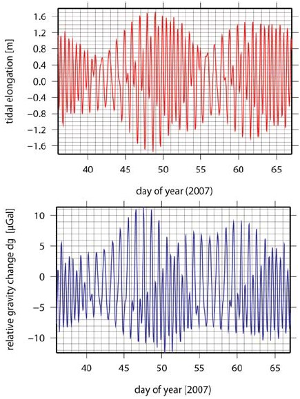
Hence, in order to investigate the ocean tides in the area of Belgrano II station, GNSS (GPS/GLONASS) should be applied to infer information complementary to tidal gravimetry, given the advantage of a direct observation of the motion of the glacier. First, to get an impression of the magnitude of the ocean tides and the corresponding effect of ocean tidal loading in the area of investigation, a model tide series was computed using the model TPXO6.2 (Egbert and Erofeeva 2002) and the SPOTL software (Agnew 1996). To meet that cell of the model which is located closest to Vahsel Bay, the coordinates 77.8°S and 34.8°W were found (location denoted by P in Fig. 2). The expected amplitude of the ocean tides is about 1.7 m at that location (Fig. 3a). The corresponding ocean tidal loading signal at Belgrano II is estimated to have amplitude of about 10 mGal as shown in Figure 3b, which would be far above the accuracy level to be expected from the gravimetric tide series.
Figure 3: Prediction of ocean tides for the location P (Fig. 2) - upper panel (3a) - and prediction of relative gravity changes caused by ocean tidal loading at Belgrano II - lower panel (3b). Both series were computed for a time interval of one month, using the model TPXO6.2 (Egbert and Erofeeva, 2002) and the SPOTL software (Agnew, 1996).
GPS observations at the Vahsel Bay glacier
To carry out real observations, a GPS station was set up for about three days in February 2007 (location denoted by GPS in Fig. 2). The set up is shown in Figure 4. A quick-and-dirty analysis of the GPS data was done using an adapted version of Bernese Software 5.0 (Dach et al., 2007) to solve for a kinematic positioning. As a re-sult, position time series - both in the horizontal as well as in the vertical direction - are derived. These preliminary position ti-me series are shown in Figure 5. It is clear, that further work has to be done in order to gain an improved solution in case of weak satellite geometries or to count for other effects that may still deteriorate the solution. Nevertheless, some conclusions can be drawn from the data: First, fitting a linear trend to the horizontal position changes yields velocities of 67 m/year for the north and -113 m/year for the east direction, resulting in a northwest flow of 131 m/year. Although this velocity measure has to be regarded as preliminary and, therefore, has a large error (even more when considering the very short time span of the observations is considered), it confirms the direction of the glacier flow and the order of magnitude of its velocity. Second, when comparing the vertical position time series with the ocean tide predictions (Fig. 5, lower panel) it appears that the GPS station was indeed placed at the floating glacier and that (at this position) the glacier follows the ocean tide - there is a very good agreement in phase. In the amplitude a certain damping is visible, which can be expected following the discussion above. Further investigation is needed in that respect.
Figure 4: Temporary GPS station at the Vahsel Bay glacier (location denoted by GPS in Fig. 2). In the background, the Bertrab Nunatak is visible.
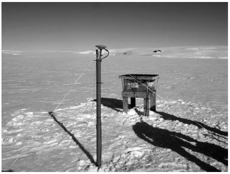
Figure 5: Preliminary results of a quick-and-dirty analysis of the GPS observations at the Vahsel Bay glacier using an adapted version of Bernese Software 5.0 to yield kinematic positions (north and east: upper panels, vertical: lower panel). The green lines show a linear fitting of the horizontal position change. For the vertical, the model predictions of the models TPXO6.2 (blue curve) and FES99 (red curve) are plotted for comparison.

Tidal gravimetric time series at Belgrano II station
For the tidal gravimetry, an especially constructed and prepared hut in the area of Belgrano II is being used (Fig. 6). A hard excavation work was carried out removing more than two cubic meters of intricated granitic stones in order to erect a concrete pillar aiming at a mechanically uncoupling from the surrounding ground and foundations as much as possible. Small grain stones were used to fill up the space between the pillar and the hut's foundations. At this pillar, the TUD gravimeter L&R D-193 together with the feedback DFB-144 as well as the IAA gravimeter G-748 were set up at the beginning of February 2007 (Fig. 7). To allow for a better thermal insulation a thermal box made of Styrodur was erected around the pillar. Further material was put in at the ground to gain the best possible insulation also from beneath.
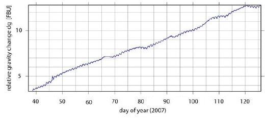
The simultaneous observations with two gravity meters allow to cross-check the performance of the instruments as well as to achieve redundancy. The preliminary raw time series of gravimeter L&R D-193 is shown in Figure 8. This raw time series has still to be corrected for offsets, spikes and the gravimeter drift. Nevertheless, already now the tidal signal is clearly visible. Once the time series observation is finished, it is subject to the processing of the entire data record to estimate and to separate the contributions from solid earth tide, from ocean tidal loading as well as from atmospheric loading. For the latter contribution we will make use of meteorological data being recorded at Belgrano II. After the successful completion of the observations, the instruments need to be moved to San Martín during the upcoming Antarctic season 2007/2008.
Figure 6: Location of the gravimetry hut in Belgrano II station. Upper panel: View in northern direction, the hut is situated in the foreground (center), close to the ozone building. Lower panel: View in north-east direction.

Figure 7: Set-up of the instruments at a grounded pillar within the gravimeter hut, Belgrano II: IAA gravity meter L&R G-748 (left), TUD gravity meter L&R D-193 (right).
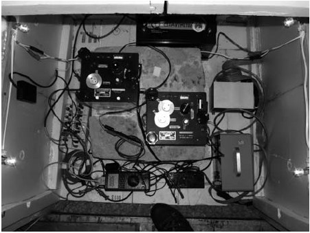
Figure 8: Time series of the gravity registration with gravity meter L&R D-193 at Belgrano II (preliminary raw data, feedback units), February 6 to May 5, 2007.
CONCLUSIONS
The feasibility of conducting gravimetric tide series has been demonstrated. Especially in polar regions this technique provides independent data complementary to GNSS observations. For stations close to the coast the reliability of estimating ocean tide effects from models depends not only from the used ocean tide model itself, but also from the realization of the land-ocean mask. Carrying out a joint Argentine-German project, we can state that the location of the current gravimeter station in Belgrano II at the south-east coast of the Weddell Sea, close to the Filchner Ice Shelf, gives us the great opportunity to test the ocean tide models in that region, especially with regard to the poorly determined constituents M2 and S2. Additional GPS measurements on the floating ice enabled us to directly observe the ocean tides despite a certain damping of the tidal amplitudes that has been observed due to the location of the grounding zone and the mechanical properties of the ice. Combining gravimetry and GPS enables to better discriminate the different effects of ocean tides, ocean tidal loading, solid earth tides and atmospheric loading.
ACKNOWLEDGEMENTS
This joint Argentine-German project is a contribution to the International Polar Year 2007/2008 and its project POLENET. The support of Comando Conjunto Antártico, Comando Antártico de Ejército (CAE) and Dirección Nacional del Antártico (DNA) is gratefully acknowledged. We would like to thank the people of Ejército Argentino and of Laboratorio Belgrano (LaBel), overwintering at Belgrano II station during 2006 and 2007, respectively, for their great support in setting up the gravimeter hut and controlling the gravimeter observations. This joint Argentine-German project is supported by the bilateral scientific-technological cooperation program of SECyT (Secretary of Science, Technology and Productive Innovation, Argentina, grant AL/PA/05-AVII/009) and BMBF (Federal Ministry of Education and Research, Germany, grant ARG-01/Z08).
WORKS CITED IN THE TEXT
Agnew D.C. 1996. SPOTL: Some Programs for Ocean-Tide Loading. SIO Ref. Ser. 96-8, 35 p., Scripps Institution of Oceanography, La Jolla, CA (version 3.2.1 of 26 July 2005). [ Links ]
Bos, M.S., Baker, T.F., Lyard, F.H., Zürn, W.E., and Rydelek, P.A. 2000. Long-period lunar Earth tides at the geographic South Pole and recent models of ocean tides. Geophysical Journal International 143(2): 490-494. [ Links ]
Bos, M.S., Baker, T.F., Röthing, K., and Plag, H.P. 2002. Testing ocean tide models in the Nordic seas with tidal gravity observations. Geophysical Journal International 150: 687-694. [ Links ]
Dach, R. 2007. Bernese Software 5.0. Software Manual, University of Bern. [ Links ]
Dietrich, R., Rülke, A., and Scheinert, M. 2005. Present-Day Vertical Crustal Deformations in West Greenland from Repeated GPS Observations. Geophysical Journal International 163(3): 865-874. doi: 10.1111/j.1365-246X. 2005. 02766.x. [ Links ]
Egbert, G.D. and Erofeeva, S.Y. 2002. Efficient inverse modeling of barotropic ocean tides. Journal of Atmospheric Oceanic Technology 19(2): 183-204. [ Links ]
Horwath, M. and Dietrich, R. 2006. Errors of regional mass variations inferred from GRACE monthly solutions. Geophysical Research Letters 33: L07502, doi:10.1029/2005GL 025550. [ Links ]
Horwath, M., Dietrich, R., Baessler, M., Nixdorf, U., Steinhage, D., Fritzsche, D., Damm, V., and Reitmayr, G. 2006. Nivlisen, an Antarctic ice shelf in Dronning Maud Land: Geodeticglaciological results from a combined analysis of ice thickness, ice surface height and ice flow observations. Journal of Glaciology 52 (176): 17-30. [ Links ]
King, M. and Aoki, S. 2003. Tidal observations on floating ice using a single GPS receiver. Geophysical Research Letters 30(3): 1138, doi:10.1029/2002GL016182. [ Links ]
King, M., Penna, N. T., and Clarke, P. J. 2005. Validation of ocean tide models around Antarctica using onshore GPS and gravity data. Journal of Geophysical Research 110: B08401, doi:10.1029/2004JB003390. [ Links ]
King, M.A. and Padman, L. 2005. Accuracy assessment of ocean tide models around Antarctica. Geophysical Research Letters 32: L23608, doi:10.1029/2005GL023901. [ Links ]
Melchior, P. and Francis, O. 1996. Comparison of Recent Ocean Tide Models Using Ground-Based Tidal Gravity Measurements. Marine Geodesy 19: 291-330. [ Links ]
Padman, L. and Fricker, H. A. 2005. Tides on the Ross Ice Shelf observed with ICESat. Geophysical Research Letters 32: L14503, doi:10.1029/2005GL023214. [ Links ]
Sato, T., Ooe, M., Nawa, K., Shibuya, K., Tamura, Y., and Kaminuma, K. 1997. Longperiod tides observed with a superconducting gravimeter at Syowa Station, Antarctica, and their implication to global ocean tide modeling. Physics of Earth Planetary Interior 103 (1): 39-53. [ Links ]
Steigenberger, P., Rothacher, M., Dietrich, R., Fritsche, M., Rülke, A., and Vey, S. 2006. Reprocessing of a global GPS network. Journal Geophysical Research 111: B05402, doi: 10.1029/2005JB003747. [ Links ]
Vaughan, D.G. 1994. Investigating tidal flexure on an ice shelf using kinematic GPS. Annals of Glaciology 20: 372-376. [ Links ]
Recibido: 11 de septiembre, 2007
Aceptado: 1 de noviembre, 2007

