


Servicios Personalizados
Revista

Articulo
 Inglés (pdf)
 Articulo en XML
 Referencias del artículo
 Enviar articulo por email
Indicadores
-
 Citado por SciELO
Links relacionados
-
 Similares en
SciELO
Similares en
SciELO
Compartir

 Permalink
Revista de la Asociación Geológica Argentina
versión impresa ISSN 0004-4822versión On-line ISSN 1851-8249
Rev. Asoc. Geol. Argent. v.64 n.1 Buenos Aires abr. 2009
Darwin's observation in South America: what did he find at agua de la zorra, Mendoza province?
Stella Poma*, Vanesa D. Litvak *, Magdalena Koukharsky*, E. Beatriz Maisonnave and Sonia Quenardelle*
Laboratorio de Petrología, Departamento de Ciencias Geológicas, FCEN (UBA) y
*CONICET. Emails: stella@gl.fcen.uba.ar; vane@gl.fcen.uba.ar; mkou@gl.fcen.uba.ar; beatriz@gl.fcen.uba.ar; sonia@gl.fcen.uba.ar
ABSTRACT: Scarcely 23 km from Uspallata, along the track of the old national highway 7, lies the district of Agua de la Zorra, in Mendoza province in western Argentina. Charles Darwin visited the area during his South American journeys in the 19th century and discovered a geological sequence that contained a paleoflora never described before. The flora includes an important number of species, particularly what is considered a small conifer forest with many silicified trunks still in life position. Darwin described and interpreted the sequence as sedimentary; his records show a very detailed level of observation. He also wondered about the processes that would cause the burial of the paleoflora, which he considered had happened in a marine sedimentary environment. In the modern geological framework and after a detailed study of the rocks containing the trunks, it is now interpreted that the conifer forest was buried by pyroclastic flows. Darwin accurately described the fine volcanic materials as an essential part of the deposit, but the key of the enigma about the origin of the deposits and the burial of the forest is the identification of the pyroclastic flow features; these were unknown process at the time of Darwin´s observations and interpretation.
Keywords: Darwin Forest; Pyroclastic flow; Triassic; Agua de la Zorra; Mendoza province.
RESUMEN: Las observaciones de Darwin en Sudamérica: ¿Qué encontró en Agua de la Zorra, provincia de Mendoza? A escasos 23 km de Uspallata, a lo largo de la antigua ruta nacional 7, se encuentra la localidad de Agua de la Zorra en la provincia de Mendoza al oeste de Argentina. La región fue explorada por Charles Darwin durante su viaje por Sudamérica en el siglo XIX. Allí descubrió una secuencia geológica conteniendo una paleoflora que no había sido descripta hasta entonces. La flora incluye un importante número de especies y particularmente, un pequeño bosque de coníferas, los que se encuentran silicificados, y en posición de vida. Darwin describió e interpretó la secuencia como sedimentaria; sus notas y descripciones muestran un alto nivel de detalle en las observaciones. Darwin además se cuestionó acerca de los procesos que habrían causado el sepultamiento de la paleoflora, la que de acuerdo a sus deducciones ocurrió en un ambiente sedimentario marino. En el contexto geológico moderno y como consecuencia de un estudio detallado de las rocas que contienen los troncos, se interpreta que el bosque de coníferas fue sepultado por flujos piroclásticos. Darwin fue acertado en describir material volcánico como constituyente esencial del depósito, pero la clave del enigma acerca del origen de la secuencia y el soterramiento del bosque radica en la identificación de las características del depósito. Corresponden a acumulaciones producto del volcanismo fragmentario; que incluye un conjunto de procesos desconocidos al tiempo de las observaciones e interpretación de Darwin.
Palabras clave: Bosque de Darwin; Flujo piroclástico; Triásico; Agua de la Zorra; Provincia de Mendoza.
INTRODUCTION
Charles Darwin travelled around South America between 1832 and 1835. While staying at Valparaiso - one of Chile's most important seaports - during July 1834, HMS Beagle underwent repairs and Captain FitzRoy faced some financial difficulties. This situation provided Dar-win with some spare time and at his expense took a six week land expedition to the east, i.e., the High Andes in Chile and Argentina (Fig. 1). During this journey, Darwin recorded everything he found. In Chapter VII of one of his journals (Darwin 1846) he described the cordilleran geology, particularly the Agua de la Zorra region in Uspallata in Mendoza province. There he found a thick sequence, which he considered sedimentary, that contained some trunks never described before. The objective of this work is to revise Darwin´s XIX century observations at Agua de la Zorra area in the modern geological framework.
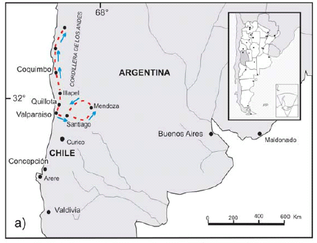

Figure 1: a) Path followed by Darwin from Valparaiso, towards the north in Chile, and towards the east in Argentina, where he visited the Precordillera in Mendoza. b) Geographical location of Darwin Forest in the Agua de la Zorra area, in Uspallata, Mendoza province.
DARWIN´S OBSERVATIONS
First observations of Darwin in the region of Agua de la Zorra in Uspallata are mentioned in Chapter VII (Darwin 1846), where he describes the area and refers to the paleoflora found as: "… I counted the stumps of fifty-two trees. They projected between two and five feet above the ground, and stood at exactly right angles to the strata, which were here inclined at an angle of about 25° to the west". One of the aspects that amazed him was that the trunks were in life position and well preserved. He not only described his finding but also asked advice from specialists about the type of flora: "…Eleven of these trees were silicified and well preserved: Mr. R. Brown has been so kind as to examine the wood when sliced and polished; he says it is coniferous, partaking of the characters of the Araucarian tribe, with some curious points of affinity with the Yew".
His records show a very detailed level of observation: "All the stumps have nearly the same diameter, varying from one foot to eighteen inches; some of them stand within a yard of each other; they are grouped in a clump within a space of about sixty yards across". "They all stand at about the same level. The longest stump stood seven feet out of the ground: the roots, if they are still preserved, are buried and concealed. No one layer of the mudstone appeared much darker than the others, as if it had formerly existed as soil".
Paragraphs ahead, he wondered about the processes that may have explained the origin of the deposits and the associated paleoflora: "Certainly the upright trees have been buried under several thousand feet in thickness of matter, accumulated under the sea. As the land, moreover, on which the trees grew, is formed of subaqueous deposits, of nearly if not quite equal thickness with the superincumbent strata, and as these deposits are regularly stratified and fine-grained, not like the matter thrown up on a sea-beach, a previous upward movement, aided no doubt by the great accumulation of lavas and sediment, is also indicated".
He interpreted a possible origin for the deposits taking into account the regional geological setting known then: "At first I imagined, that the strata with the trees might have been accumulated in a lake: but this seems highly improbable; for, first, a very deep lake was necessary to receive the matter below the trees, then it must have been drained for their growth, and afterwards re-formed and made profoundly deep, so as to receive a subsequent accumulation of matter several thousand feet in thickness. And all this must have taken place necessarily before the formation of the Uspallata range, and therefore on the margin of the wide level expanse of the Pampas! Hence I conclude that it is infinitely more probable that the strata were accumulated under the sea".
STRATIGRAPHIC SETTING OF DARWIN´S DISCOVERY
Darwin's discovery at Agua de la Zorra is located along the old National Highway 7, which links Caracoles de Villavicencio with the town of Uspallata (Fig. 1). The best exposures occur about 800 m to the east of Agua de la Zorra locality (32° 28'39" S and 69°09'09" W). It was only in 1910 that the deposits where Darwin's paleoflora was found were described again by Stappenbeck (1910) and later by Harrington (1941, 1971). Figure 2 shows a schematic geological map of the area. The sequence containing the trunks, sedimentary in origin as Darwin described, is partially covered by alkaline basalts and intruded by sills of similar composition.
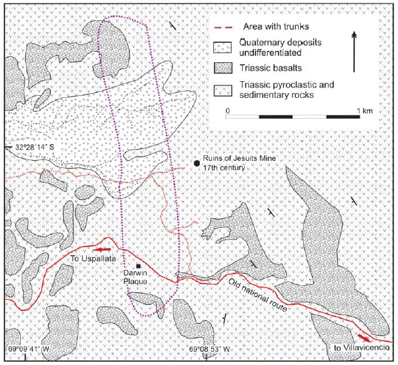
Figure 2: Schematic geologic map of the Agua de la Zorra region in Uspallata, Precordillera of Mendoza, Argentina.
The abundant remains of conifers render it a classic site not only from the paleontological point of view, but also from a geological and historical perspective. Thus, the name of Bosque de Darwin (Darwin's Forest) for the site was formalized in the geological reports of Map 3369- 09, Uspallata (Brodtkorb et al. 1997, Cortés et al. 1997). The geological record of the region was studied by several authors, who also agreed a sedimentary origin for the deposits described by Darwin (Stipanicic 1972, 1979, Rolleri and Criado 1986, Strelkov and Alvarez 1984, Kokogian and Mancilla 1989, Ramos and Kay 1991, Morel 1994, Cortés et al. 1997, Kokogian et al. 1999). Stratigraphicaly, Cortés et al. (1997) identified the deposits described by Darwin as part of the Triassic Paramillo Formation within the Uspallata Group. In a recent analysis of a section of the sequence, Poma et al. (2004) described the volcaniclastic characteristics of the rocks containing the trunks; these are still under study.
The area of Agua de la Zorra is part of the Cuyo Triassic extensional basin. According to Kokogian et al. (1999) the Cuyo Basin evolved through three depositional sequences that characterized different stages of rift evolution. The lowermost deposits, Early Triassic in age, were included in the synrift I stage by Kokogian et al. (1999) which is composed of coarse-grained conglomerates and breccias deposited in alluvial fan areas. These coarse-grained rocks are commonly found close to positive areas and basinwards taper into fluvial sandy ephemeral braided deposits and finally pass into muddy playa-lake sequences in the central parts of the basin. Isolated levels of rhyolitic tuffs occur at some places.
The second sequence, labelled as the synrift II stage (Kokogian et al. 1999), was very probably deposited during the Middle Triassic and shows a wider areal distribution that the above considered synrift I. During this time prevailed different types of high-sinuosity river deposits composed of cross-bedded sandstones, conglomerates and mudstones. Lacustrine and deltaic sediments also appear in this section and indeed are dominant at the uppermost level of this section. Lake deposits are made up of interbedded sandstones-mudstones sequences with sporadic intercalations of organic-rich shales. A noticeable feature of this interval is the occurrence of abundant pyroclastic levels covered by thick basaltic lava flows and sills included in the uppermost part of the synrift II stage.
Finally, during the Late Triassic a sag phase sequence was defined by Ramos and Kay (1991) and Kokogian et al. (1999), which characterized the final stages of subsidence in the basin under limited tectonic and magmatic activity. At this time prevailed sandstones and conglomerates sedimented by anastomosed and braided rivers that were covered by transgressive mudstones, shales and tuffs deposited in lacustrine environments.
GEOLOGY OF THE AGUA DE LA ZORRA REGION
Volcaniclastic deposits
In the Agua de la Zorra region, as Darwin described, there are a series of rocks containing tree trunks typical of coniferous - including Araucarioxylon sp. among them (Brea 1997, 2000) - and buried in life position. As shown in figure 3a, b, and c, Darwin´s paleoflora is contained in a sedimentary/volcaniclastic sequence covered by alkaline basalts, both of Triassic age. According to field and microscope observations the material interbedded with the fossils comprises two main deposit types that are repeated with different thickness along the sequence.
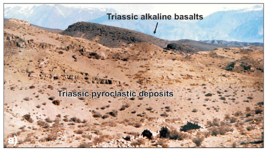

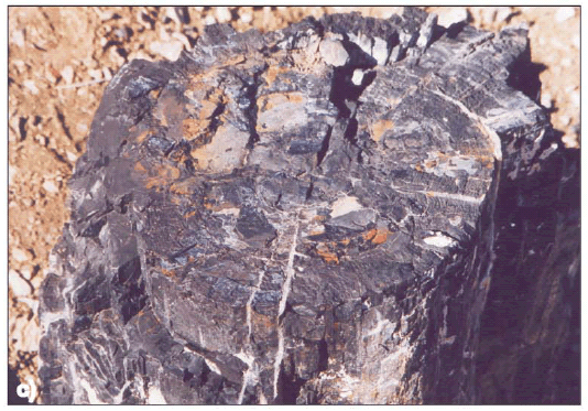
Figure 3: a) General view to the SW of the Triassic pyroclastic deposits covered by Triassic alkaline basalts; b) Closer view of the trunk, paleosoil, roots, and pyroclastic sequence including basal levels; c) Detailed view of the trunk, approximate diameter 40 cm.
One of them is a characteristic pyroclastic flow deposit with crystal fragments, glass shards, pumice lapilli, all of them magmatically fragmented juvenile clasts product of their explosive origin. The crystals are small and irregular quartz grains and tabular or irregular fragments of oligoclase-andesine plagioclase. The matrix contains abundant angular glass shards, most of which have cuspate shape (Fig. 4a, and b). Fine ash fills the interstices between the shards. The shards are characteristically undeformed and some of them retain original bubble wall shapes, suggesting that the deposition was at moderate temperature. The lapilli pumices are concentrated at the lower part of the deposits and are smaller than 16 mm (medium lapilli). Occasionally it is possible to find silicified plant sprigs.
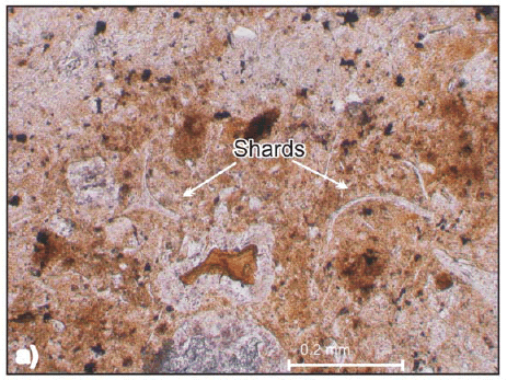
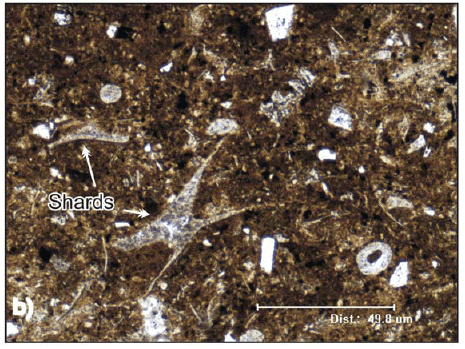
Figure 4: Thin section pictures of Paramillo Formation tuffs. a) Rhyolitic vitric tuff with undeformed shards (Parallel light); b) Rhyolitic vitric tuff with triaxon shards and rounded palagonite fragments of basaltic origin (Cross polarized light).
The rock is classified as a rhyolitic to dacitic medium lapilli tuff (White and Houghton 2006) with thin (decimetre scale) variably diffuse layering, thickness varying between 50 and 20 centimetres. They are defined by gradational grain size between pumice and lapilli. The set repeats itself several times along the sequence. Typically the diffuse stratification is subparallel with local gradual thinning. The rock commonly grades vertically into massive beds. Associated with the tuff and separated by a clearly noticeable surface there is a thin (centimetre to few decimetre scale) and well sorted deposit. It is poorly lithified and is interpreted as an air fall deposit that accompanied the emplacement of pyroclastic flows. It was preserved because a later ignimbritic flow covered it and protected it from erosion.
The conspicuous features in these rocks are pyroclastic cuspate glass shards and pumice fragments. The shards and delicate spines of bubble walls were deposited undeformed, they indicate that the deposit is primary and has not been reworked from primary deposits (Fig. 4a, and b). The glassy shards are now transformed in zeolite and silica material. In the area, some massive lapilli tuff show normal vertical grading patterns defined by more or less gradual changes in grain size. Vertical grading typically occurs across a few decimetres. The record begins (Fig. 5) with a coarse lapilli tuff (White and Houghton 2006) (grain size average between 16 to 64 mm of pumice fragments), crystal fragments and lithics with minor amounts of glassy matrix (<10%), gradually changing to fine lapilli without or with only few pumice fragments. At the base these rocks show channel morphology probably indicative of some erosive behaviour by the flow. In this deposit, generally at lower levels, it is possible to notice small gas escape pipes. These structures are richer in pumice lapilli, lithics and poorer in fine ash than the enclosing tuff. This is characteristic of the removal of fine ash as a result of elutriation by gas escaping through the uncompacted deposit. The pipes were formed simultaneously with the flow accumulation, again illustrating the primary nature of the deposit. The pyroclastic rocks are intercalated with fluvial lenses of fine sandstones to conglomerate, interbedded with shales.
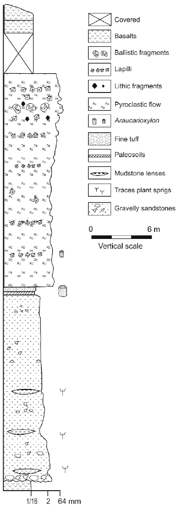
Figure 5: Lithological stratigraphic section of Paramillo Formation of Uspallata Group near Darwin´s monument.
Geomorphology and patterns of thickness variation of the pyroclastic deposits suggest a possible western provenance even though there is no conclusive evidence.
Tuff-basalts transition
The pyroclastic and sedimentary rocks described are intercalated and covered with Triassic mafic rocks. These are sills and lava flows of basaltic composition (Massabie 1986, Ramos and Kay 1991). In the Agua de la Zorra region the olivine-bearing basalts are easily noticeable because of their dark colours, fine grain and scoriaceous or amygdaloidal textures. The vesicles were partially filled with calcium carbonate and silica and zeolites in subordinate amounts. These materials are conspicuous in altered basalts and sometimes are found in pyroclastic and sedimentary rocks.
The lower part of the basalts are resting over a poorly consolidate rhyolitic tuff that contains small spheres of basaltic palagonite lava. The size of the spheres is variable but no larger than 5 cm. They represent the interaction between lava flows and unconsolidated water soaked material. Upwards there are peperites that result from the mingling between basalt, rhyolitic tuff and clastic sediments in variables proportions. These textures suggest that the basalts were produced shortly after or simultaneously with the pyroclastic activity and sedimentation. There were not identified volcanological structures that could relate the rhyolitic pyroclastic deposits with the basaltic lava flows, seeming the latter the result of fissure eruptions.
CHARACTER AND ORIGIN OF THE DEPOSITS
Just as Darwin described, the trunks are arranged vertical to the layers. They stand at approximately the same level, and although Darwin did not identify a normal paleosoil, he understood that these trees had to grow in a dry substrate. He mentioned (Darwin 1846): "As the trees obviously must once have grown on dry land, what an enormous amount of subsidence is thus indicated! Nevertheless, had it not been for the trees, there was no appearance which would have led any one even to have conjectured that these strata had subsided". Obviously, he was amazed at the great thickness of sediments that there are in the sequence, which hinders any simple interpretation on the origin of the set.
Finally, Darwin makes up his mind and chooses the simplest interpretation, even though this is not satisfactory. "That it is infinitely more probable that the strata were accumulated under the sea". On the other hand he observes and describes that the fine material plastered around the trunks as a package preserves the mould with the external texture of the plants: "The bark round the trunks must have been circularly furrowed with irregular lines, for the mudstone round them is thus plainly marked".
According to the observed and previously described characteristics of the deposits, such as their areal distribution, changing thickness, flow nature, type of structures and textures, we interpret that the deposit that encloses Darwin´s Flora in the area of Agua de la Zorra was originated as a consequence of a phreatomagmatic eruption (Poma et al. 2004). The key of the enigma about the origin of the deposits rests in the identification of the pyroclastic features of the rocks containing the trunks, particularly their phreatomagmatic origin; this was an unknown process at the time of Darwin´s observations and interpretation (Darwin 1844).
Along geologic time and humankind history there are numerous examples of flora, fauna and populations buried by this type of processes. Seldom were human witnesses present while volcanic activity was taking place. In those rare cases, men and women were able to describe the catastrophic episode. Pompeii (79 BC), for example, was buried under four meters of ash and debris. Pliny the Younger, a Roman soldier, witnessed much of the eruption (Francis 1993). Pompeii was covered over with a hot cloud of volcanic ash, steam and some mud material. The pyroclastic cloud flowed down the side of the volcano at a speed of 30 meters per second (Francis 1993). It took less than four minutes for the pyroclastic flow to travel from Vesuvius to Pompeii a few kilometres away. In 1815 more than 100,000 people died when Mount Tambora erupted on the Indonesian island of Sumbawa (Sutawidjaja et al. 2006). Despite the presence of witnesses in Mount Tambora and the discovery of Pompeii, among other eruptions, in Darwin´s time advanced knowledge about the mechanism of this volcanic activity was limited.
It was only during the last century and after many eruptions that pyroclastic flows were thoroughly studied and documented by hundreds of volcanologists worldwide, such as the 1980 Saint Helens among others. With detailed monitoring and modeling of active volcanism, eruption styles, type of ejecta, flows and clouds were understood and only then past volcanic expressions could be properly interpreted. In the same way it was only recently that science acknowledged the significant impact of these types of phenomena on climatic change at a planetary scale.
A phreatomagmatic eruption was also responsible for the burial of Darwin`s forest in Agua de la Zorra. In continental volcanic environments the interaction between hot magma and water frequently produces this kind of volcanism, in which a voluminous explosive eruption of magmatic ejects emulsionated with magmatic and external volatiles. Figure 6 shows an interpretation of the eruption. The characteristics of the pyroclastic sequence of Agua de la Zorra allow us to make another interpretation: The eruption was not destructive (at least not in that sector) as the trees remain in life position; so it is inferred the eruption was not laterally directed and can be supposed to be vertical. However, there is no concluding evidence to disregard a lateral eruption, especially if the deposits are distal or out of the lateral blast influence.
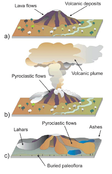
Figure 6: Schematic representation of a three stage evolution for the Darwin´s Forest burial. a) Inactive volcanic center surrounded by the forest; b) Pyroclastic eruption with associated volcanic plumes and pyroclastic flows reaching Darwin´s Forest; c) Darwin´s Forest is buried by the pyroclastic flows and ashes. Lahars recognized by Brodtkorb et al. (1997) are included in the sketch.
Volcanic activity was intense enough to eliminate most of the soft tissues of the flora such as leaves, which are more abundant in the sedimentary levels. Burial must have been in a short time, as a consequence of one or more eruptions but close in time, because there are no recorded breaks between the flows that cover the trunks.
Only one paleosoil was observed below a tree (Fig. 3b). Its thickness is less than 50 cm. It is dark with root marks. It was covered by a thin and diluted flow with low particle/gas ratio; it possibly was a base surge above which a series of pyroclastic flows accumulated. They are stratified and the sequence ends with an ash fall, possibly related to the co-ignimbritic cloud. There is no clear evidence of an extended ash fall deposit besides the coignimbritic cloud deposits already mentioned.
In that regard, the eruptive column is not considered to be too high. As indicated by Sparks and Wilson (1982), a high proportion of steam in phreatomagmatic eruptions results in shorter columns. Changing thickness and varying structures and textures seem to imply an unstable feeding system from the magma chamber to the eruptive column. Instability could have been the consequence of the variations in the magma supply and in any case is responsible for the recorded duality in the massive form or diffusely stratified deposits. This interpretation is consistent with a first deposit in the area made up of initial base surge such as the ones locally observed overlying the paleosoil. Eruptions of these characteristics are violent and also of rapid deposition. This amount of ash had already surprised Darwin who, as we mentioned earlier, had interpreted it as material of sedimentary origin.
CONCLUSIONS
The value of Darwin´s work is the accuracy of the descriptions and the detailed degree of his observations, which are still valid nowadays. He was successful in the interpretation that the forest was buried in life. Despite Darwin misinterpreted the origin of the deposits as sedimentary, he was accurate in describing the fine volcanic materials as an essential part of them, although he never considered the eruptive process as the one responsible for the burial. The present interpretation as a phreatomagmatic mechanism is now plausible because of the advances in volcanological knowledge and understanding during the latter years of the Twentieth Century.
ACKNOWLEDGEMENTS
This work was funded by University of Buenos Aires grant UBACYT X207. The authors are particularly grateful to S. Kay, E. Llambías and P. Sruoga for their review of the manuscript and to Miguel Griffin for his valuable suggestions to improve the English version.
WORKS CITED IN THE TEXT
1. Brodtkorb, A., Cortés, J.M., González Bonorino, G. and Koukharsky, M. 1997. Sitios de interés geológico correspondientes a la Hoja 3369-09, Uspallata, provincia de Mendoza, SEGEMAR, unpublished, 40 p. Buenos Aires. [ Links ]
2. Brea, M. 1997. Una nueva especie fósil del género Araucarioxylon Kraus 1870 emend. Maheshwari 1972 del Triásico de Agua de la Zorra, Uspallata, Mendoza, Argentina. Ameghiniana 34: 485-496. [ Links ]
3. Brea, M. 2000. Paleoflora triásica de Agua de la Zorra, Uspallata, provincia de Mendoza, Argentina: Lycophyta y Filicophyta. Ameghiniana 37: 199-204. [ Links ]
4. Cortés, J.M., González Bonorino, G., Koukharsky, M., Pereyra, F. and Brodtkorb, A. 1997. Hoja geológica 3369-09 Uspallata, provincia de Mendoza. SEGEMAR, (unpublished report) 165 p., Buenos Aires. [ Links ]
5. Darwin, C. 1846. Geological observations on South America. Being the third part of the geology of the voyage of the Beagle, under the command of Capt. Fitzroy, R.N. during the years 1832 to 1836. Smith Elder and Co. 280 p., London. [ Links ]
6. Darwin, C. 1844. Geological observations on the volcanic islands visited during the voyage of H.M.S. Beagle. Smith, Elder and co., 176 p., London. [ Links ]
7. Francis, P. 1993. Volcanoes, a planetary perspective. Clarendon Press. 443 p., New York. [ Links ]
8. Harrington, H.J. 1941. Investigaciones geológicas en las sierras de Villavicencio y Mal País, provincia de Mendoza. Dirección Nacional de Geología y Minería, Boletín 49, 54 p., Buenos Aires. [ Links ]
9. Harrington, H.J. 1971. Descripción geológica de la Hoja 22c, "Ramblón", provincias de Mendoza y San Juan. Dirección Nacional de Geología y Minería, Boletín 114, 81 p., Buenos Aires. [ Links ]
10. Kokogian, D.A. and Mancilla, G.H. 1989. Análisis estratigráfico y secuencial de la Cuenca Cuyana. In Chebli, G. and Spalletti, L. (eds.) Cuencas Sedimentarias Argentinas. Facultad de Ciencias Naturales, Universidad Nacional de Tucumán, Serie Correlación Geológica 6: 169-201. [ Links ]
11. Kokogian, D.A., Spalletti, L., Morel, E., Artabe, A., Martínez, R.N., Alcober, O.A., Milana, J.P., Zavattieri, A.M. and Papú, O.H. 1999. Los depósitos continentales triásicos. In Caminos, R. (ed.) Geología Argentina, Instituto de Geología y Recursos Naturales, Anales 29(15): 377-398, Buenos Aires. [ Links ]
12. Massabie, A. 1986. Filón capa Paramillos de Uspallata, su caracterización geológica y edad, Paramillo de Uspallata, Mendoza. Primeras Jornadas sobre Geología de la Precordillera, Asociación Geológica Argentina, Serie A, 2: 325-330. [ Links ]
13. Morel, E.M. 1994. El Triásico del cerro Cacheuta, Mendoza (Argentina) Parte I: geología, contenido paleoflorístico y cronoestratigrafía. Ameghiniana 31: 161-176. [ Links ]
14. Poma, S., Quenardelle, S. and Koukharsky, M. 2004. Un flujo piroclástico triásico en la Formación Paramillo, provincia de Mendoza. In Brodtkorb, M. K. De, Koukharsky, M., Quenardelle, S. and Montenegro, T. (eds.) Avances en Mineralogía, Metalogenia y Petrología 2004, 385-390, Río Cuarto. [ Links ]
15. Ramos, V.A. and Kay, S. 1991. Triassic rifting and associated basalts in the Cuyo Basin, central Argentina. In Harmon, R.S. and Rapela, C.W. (eds.) Andean Magmatism and its Tectonic Setting, Geological Society of America, Special Paper 265: 79-91. [ Links ]
16. Rolleri, E.O. and Criado, R.P. 1968. La Cuenca Triásica del norte de Mendoza. Terceras Jornadas Geológicas Argentinas (Comodoro Rivadavia), Actas 1: 1-76. [ Links ]
17. Sparks, R.S.J. and Wilson, L. 1982. Explosive volcanic eruptions- V. Observations of plume dynamics during the 1979 Soufrière eruption, St. Vincent. Geophysical Journal Internacional 69: 551-570. [ Links ]
18. Stappenbeck, R. 1910. La Precordillera de San Juan y Mendoza. Ministerio de Agricultura de la Nación, Sección Geología, Mineralogía y Minería, Anales 4(3): 3-187, Buenos Aires. [ Links ]
19. Stipanicic, P.N. 1972. La Cuenca Triásica de Barreal (provincial de San Juan). In Leanza, A.F. (ed.) Geología Regional Argentina, Academia Nacional de Ciencias: 537-566, Córdoba. [ Links ]
20. Stipanicic, P.N. 1979. El Triásico del Valle del Río de Los Patos (provincia de San Juan). In Turner, J.C.M. (ed.) Geología Regional Argentina, Academia Nacional de Ciencias 1: 695-744, Córdoba. [ Links ]
21. Strelkov, E.E. and Alvarez, L.A. 1984. Análisis Estratigráfico y Evolutivo de la Cuenca Triásica Mendocina - Sanjuanina. 9° Congreso Geológico Argentino (Bariloche), Actas 3: 115-130. [ Links ]
22. Sutawidjaja, I.S., Sigurdsson, H. and Abrams, L. 2006. Characterization of volcanic deposits and geoarchaeological studies from the 1815 eruption of Tambora volcano. Jurnal Geologi Indonesia 1(1): 49-57. [ Links ]
23. White, J.D.L. and Houghton, B.F. 2006. Primary volcaniclastic rocks. Geology 34: 677-680. [ Links ]
Recibido: 27 de agosto de 2008
Aceptado: 17 de octubre de 2008

