


Services on Demand
Journal

Article
 English (pdf)
 Article in xml format
 Article references
 Send this article by e-mail
Indicators
-
 Cited by SciELO
Related links
-
 Similars in
SciELO
Similars in
SciELO
Share

 Permalink
Revista de la Asociación Geológica Argentina
Print version ISSN 0004-4822On-line version ISSN 1851-8249
Rev. Asoc. Geol. Argent. vol.64 no.4 Buenos Aires June 2009
ARTÍCULOS
Stratigraphy, tectonic and paleogeography of the Loberia coastline, southeastern Buenos Aires
Federico Ignacio Isla and Marcela Espinosa
Centro de Geología de Costas y del Cuaternario, Mar del Plata. E-mails: fisla@mdp.edu.ar, maespin@mdp.edu.ar
ABSTRACT
The Lobería coastline is dominated by cliffs cut by the inlets of creeks and rivers. These cliffs are the best place to study the relationships between the Cenozoic stratigraphic units that compose the Pampean Plain. Within the inlets, the fluvial deposits are integrated with the remains of the Quaternary sea-level variations. The present erosion of the cliffs is constantly providing fossils that made this area one of the most important sections for the Quaternary period in South America. Present contribution is an updated description considering the present knowledge about ages, a reinterpretation of the paleo-environments based on diatom assemblages, and the tectonic significance of these sequences in relation to other areas.
Keywords: Stratigraphic units; Paleogeography; Lobería.
RESUMEN: Estratigrafía, tectónica y paleogeografía de la línea de costa de Lobería, sudeste de Buenos Aires. La costa de Lobería está dominada por acantilados cortados por las desembocaduras de arroyos y ríos. Estos acantilados son los sitios ideales para el estudio de la relaciones entre las unidades estratigráficas depositadas durante el Cenozoico en la planicie pampeana. Dentro de estas desembocaduras, los depósitos fluviales están interdigitados con los remanentes de las variaciones cuaternarias del nivel del mar. La erosión de los acantilados provee constantemente restos fosilíferos que hicieron de esta área una de las secciones más importantes del Cuaternario de América del Sur. La presente contribución es una descripción actualizada del conocimiento de la edad de estos depósitos, la reinterpretación de los paleoambientes basada en las asociaciones de diatomeas, y el significado tectónico de estas secuencias en relación a otras áreas.
Palabras clave: Unidades estratigráficas; Paleogeografía; Lobería.
INTRODUCTION
The southern coast of Buenos Aires Province between Mar del Plata and Necochea, formerly named the Lobería coastline (Fig. 1), comprises the outcrops of scattered pampean sediments composing erosive cliffs, difficult to correlate but very important for their content in mega and micromammals. These cliffs are located (from east to west) at: Chocorí inlet, Bellamar and Centinela del Mar, in General Alvarado County, and Moromar and El Moro, in the Lobería County. Frenguelli (1928) already described some of these cliffs (Miramar, Chocorí, Bellamar, Centinela del Mar), which have been continuously providing fossil remains; therefore it became necessary for us to redefine some limits between the stratigraphic units, analyzing more precisely ages and facies.

The aim of this paper is to report specific descriptions, thicknesses, and grainsize data from the different stratigraphic units. Also, paleoenvironments defined by Frenguelli (1928) are reinterpreted based on their diatom-assemblages content. As Frenguelli (1928) already proposed a tectonic uplift for the coastline between Mar del Plata and Miramar, while no uplift seemed evident from Miramar to Necochea, another purpose was to use the leveling of the different Plio-Pleistocene units in order to obtain evidence to analyze the tectonic behavior of this coastline during the Quaternary.
STRATIGRAPHIC REFERENCES
The stratigraphy of this portion of the Buenos Aires coastline has been a matter of controversy due to several factors:
Preconceptions of some authors
Several authors arrived to the area with stratigraphic models conceived previously from other regions, or other continents. Frenguelli (1928) constructed a stratigraphic framework for this southern coast of Buenos Aires; later he changed significantly his scheme proposing a model based on pluvial and inter-pluvial intervals (Frenguelli 1950).
Kraglievich (1952) constructed a stratigraphic column for the Chapadmalal-Miramar cliffs, without considering the Upper Pleistocene transgression although he mentioned it as present in the region (Table 1). Later, he incorporated evidences from the northern coast of Mar del Plata, and finally he reinterpreted these units when he came to know the Centinela del Mar sequence bearing the evidences of the Upper Pleistocene transgression (1959).
TABLE 1: Stratigraphic scheme, dominant facies and maximum thickness for the coastal cliffs extending from Mar del Plata to Necochea*

Ancient paleontologists used to collect mammal bones from the cliffs without a careful stratigraphic or taphonomic control. Unfortunately, some concepts based on fossils should be reviewed as some bones could have been transported, e.g. the fluvial facies from the Lobería or Miramar formations. Some mammal groups (milodontids, Paedotherium, rodents) used to construct caves and therefore their bones could be stratigraphically transgressive, in other words younger bones in older host sediments. For example, the xenarthra bones found within the littoral eolianite corresponding to the oxygen isotopic stage (OIS) 5e (Sangamonian, Belgranense) of Centinela del Mar belong to specimens that once lived when the sandstone was already consolidated.
Confusion about some units
Informal "Mammal-stage units" (Pascual et al. 1965) have been usefully introduced to identify some units bearing macrofossils, but these units initiated a controversy between paleontologists and geologists as similar names have been assigned to chronostratigraphic units (Ameghino 1889, Frenguelli, 1928, Tonni et al. 1996, between others) A circular reasoning was originated: fossil remains led to the age of unit, but later the age of the unit conditioned new fossil discoveries.
In the last years, both units (chronostratigraphic and litostratigraphic) have been changing in different directions in relation to new evidences and/or new datings. Biostratigraphic criteria characterized by fossil assemblages were introduced (Cione and Tonni 1995), and they are subject to change when new datings could be assigned.
Overestimation of useful criteria
Several authors attempted to discern the Pampean stratigraphy introducing some useful criteria. For Kraglievich (1952, 1959), colors and grain sizes were the main tools to apply. An improvement was the concept of lateral facies that could repeat in the sequence (Frenguelli 1928); for example, similar greenish sediments could have been confused between the Lobería Formation (also the Camet Norte facies in the sense of Fasano et al. 1984), the pre-Belgranense deposits (Frenguelli 1928), or the San Andrés formation (Kraglievich 1959). Different types of caliche concretions permit to discern some litostratigraphic units at the Chapadmalal- Miramar coast (Teruggi et al. 1974, Tonni and Fidalgo 1982). The regional character of some paleosoil levels has been also used satisfactorily (Fidalgo et al. 1972, Zárate and Fasano 1989).
SETTING
The Pampa Interserrana ("plain between ranges") extends between the ranges of Tandilia and Ventania (Fig. 1). Recently, the 9 km thick Claromecó Basin has been defined between both ranges, considering a certain potential for oil production (Lesta and Sylwan, 2005), and related to the Karroo Basin, Southern Africa (Ramos and Kostadinoff, 2005). As the cliffs of this undulated plain discontinuously appear along the coast, they were assumed to record the tectonic component of the region during the Quaternary. Close to the coast, the undulations are caused by the differential erosion of the more important fluvial valleys (Chocorí, Pescado, Nutria Mansa, Malacara, El Moro).
Some of these old streams converge in the Quequén Grande valley of assymetric development (Teruggi et al. 2005) caused by a fluvial capture during the end of the Pleistocene (Cortizo and Isla 2000).
METHODS
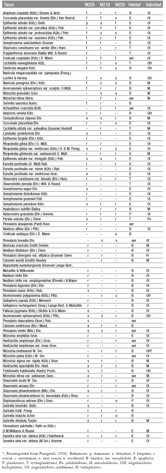
Topographic surveys (teodolite and rule) were conducted to precise some stratigraphic limits (Centinela del Mar, Punta Hermengo). Cliff outcrops were positioned by GPS. Detailed digital photography helped to compare some units between distant outcrops. Sediments were sampled at the pre-Belgranense and Belgranense units. Diatom data from Frenguelli (1926) were updated using synonyms reported by Stoermer et al. (1999). Their ecological affinities were related to salinity tolerances, and habitats were analyzed from several references (De Wolf 1982, Denys 1991 and 1992, Vos and De Wolf 1993).
RESULTS
Stratigraphic units
Schematic profiles from the cliffs were described in order to understand the behavior of the pampean sedimentation along this coastline (Fig. 2).

Figure 2: Schematic profiles of the Buenos Aires coastal cliffs between 58°05' and 58°23'W.
Chocorí estuary (38°23'38"S; 58°05'39 "W)
East of the Chocorí estuary, the base of the cliffs is composed of 2.4 m of compact green silts bearing bone remains and calcrete-filled cracks. Upwards, a layer (0.8 m thick) of silt clasts of similar composition of the matrix, bearing calcrete levels ends in a paleosoil. On top, the sequence continues with 2.4 m of a brownish diamicton with pedogenized levels on top. 1.5 m of a greenish diamicton with caliche nodules continues (OIS 5e). These deposits were similar to those outcropping at Punta Hermengo (Fidalgo and Tonni 1983). The top of the Pampean sequence ends with calcrete levels where rounded sand grains denote the Belgranense transgression.
Estancia Bellamar (38°24 04" S; 58° 06' 47"W)
These cliffs initiate with 4 m of sandy silts with caliche clasts at the base, and a calcrete level on top. A 0.5 m thick level of a calcrete and large clasts continue. Towards the top, there is 1.1 m of greenish silty sands (pre-Belgranense). The top of the sequence is composed of a sandstone 0.3 m thick containing shell remains (Belgranense in the sense of Isla et al. 2000). A poor-selected (1.16) medium sand (1.83 phi units) was sampled; 60% was composed of calcium carbonate. Gliptodon remains were recognized within the sands (Fig. 3).

Figure 3: Inverted carapache of gliptodontid in the Belgranense sandstone at Bellamar
Centinela del Mar (38°26'51"S; 58°14' 42"W)
Centinela del Mar is well known among paleontologists (Tonni et al. 1987, Scanferla et al. 2005, De los Reyes et al. 2006, Cenizo and De los Reyes, 2008, Báez et al. 2008), archaeologists (Cione et al. 2003), and geologists (Parodi and Parodi Bustos 1952, Isla et al. 2000, Schultz et al. 2004). In the year 2008 the site was declared of geologic and paleontologic interest by the General Alvarado authorities. Its importance obeys to the presence of coastal dunes of Upper Pleistocene age; stratigraphicly pointing to the OIS 5e, and therefore indicating a worldwide known event. Six profiles were surveyed at this locality (Fig. 4).

Figure 4: Schematic profiles of the Centinela del Mar cliffs (modified after Isla et al. 2000).
Compact brownish siltstones initiate the base of the cliffs, bearing calcrete levels and clasts of that carbonatic composition, with a conspicuous and extended level of a breccia, also composed of caliche. Within the profiles of the east (4 to 6), there is an ash layer that reaches a maximum thickness of 0.5 m. Volcanic sand grains, to the top of this package, are suggesting the pre-Belgranense levels defined by Frenguelli (1928); in other words, they are demonstrating the presence of an eolian supply of rounded grains related to the OIS 5e coastline.
The second major unit is recognized by laminated greenish silts, containing a diamicton on top. The greenish silts were interpreted as deposited into a shallowwater body. To the west of these outcrops, the greeninsh silts are also covering the diamicton.
The tirth unit is the characteristic and continuous layer of tabular crossbedding composed of sand grains with pieces of shells. These eolianites constitute a coastal sand barrier, composed of poor-selected (1.23-1.36) fine to medium sand (1.5- 2.13 phi units) with a 50% content of calcium carbonate. Coastal dunes have migrated from west to east. Foresets have recorded dips to the east in profiles 3 (N 90º- 110º) and 6 (N 110º-120º), but also to the northwest in profiles 1 (N 295º- 350º) and profile 4 (N 350º- 40º). Maximum slopes of the foresets have been recognized at the center of the cliff, becoming more gentle to the east (Fig. 5 a). Gliptodontid caves from Upper Pleistocene times are excavated within this coastal barrier sandstone (Fig. 5 b). Some of them are very good preserved because it was dug in sand that previously turned into an eolianite. At this locality Frenguelli (1928) did not find the loessic facies of his Basal Ensenadense units; therefore, he assigned most of the sequence to the pre-Belgranense (along the Chapadmalal cliffs, he also considered all the sequence of Punta Vorohué as deposited before the OIS 5e). On the other hand, in his visit to Centinela del Mar, Kraglievich (1959) realized that his formations Vorohué and San Andrés (described in 1952) should be considered only one. He also realized that the sandstones on top of the cliffs correspond to interglacial coastal dunes (Kraglievich 1959).
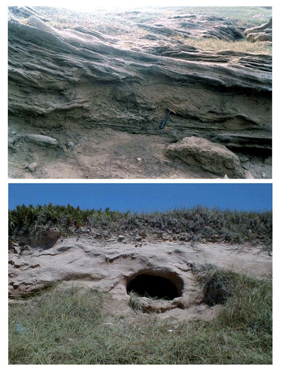
Figure 5: a) Base of dunes of OIS 5e age, migrating over a shallow pond. b) Paleocave within the Belgranense aeolian deposits.
Moromar (38°28º39"S; 58°19'12"W)
The sequence initiates with massive brownish silts composing the foot of the cliffs and also the abrasion platform. Large caves have been recognized there. Laterally, there is a stratified shallow pond (Fig. 6 a) with escoria (material produced by the impact of a small body in the surroundings; Schultz et al. 2004) and convolute bedding to the top. This pond is dipping eastwards. The top of this layer ends with calcrete levels. Upwards, a layer of about 2.5 m is composed of massive silts (laminated and burrowed at the base) with irregular clasts of caliche; laterally there are diamictons, some of them carrying escoria remains. Trough crossbeds, assymptotic to the base, are suggesting point-bar migrations (Fig. 6 b). The top of this thick package ends in a calcrete level. Over this level, the stratum is 2 m thick and consists also of a diamicton deposit with caliche pebbles. At the base, a calcrete level constitutes a paleosoil. The top of the sequence is also composed of calcrete with horizontal and vertical directions of growth.

Figure 6: a) Stratified muds with convolute bedding from a shallow pond from the base of the Moromar cliff (Vorohue Formation). b) Point-bar structure at the lower Pleistocene deposit of El Moro cliff.
El Moro (38°31'38"S; 58°18'26"W)
In this place, the Pampean sequence outcrops not far from the beach. About 1 m of a brownish diamicton, in a matrix of silt, has many calcrete levels. The uppermost calcrete level is an intraformational breccia containing rounded grains of volcanic composition, thus suggesting a supply from the Sangamonian aeolian barrier. These deposits are very common in the region and composed the top of many cliffs, as those cropping out further west at Punta Negra, Necochea (Frenguelli 1928).
Facies interpretations
Pre-Belgranense deposits from the Miramar cliffs were reinterpreted from the samples collected at Punta Hermengo by Frenguelli (1926; these deposits were called Miramar formation by Kraglievich 1952) Based on the presence of some marine diatoms he proposed a marsh for these facies. Freshwater and epiphitic taxa as Epithemia adnata were the most abundant at the three levels. Epiphitic (living over macroalgae or aquatic plants) and benthic assemblages are characteristic of low-energy environments as ponds or very shallow lakes. The marshes proposed by Frenguelli are therefore questioned in regard to sedimentological evidences and a new interpretation of his diatom assemblages. However, and considering pre-sent knowledge of the habitats and salinity tolerances of these fossil diatoms these deposits have evolved in fresh to brackish water (Table 2).
TABLE 2: Diatom content from the pre-Belgranense stage of Miramar*
Paleogeography
120,000 years ago, when the sea level was approximately 6 m over present MSL, the coast of the Argentine Pampas was completely different. There were beaches within the Río de la Plata embayment; remains of these beaches persist at the base of Belgrano cliffs (Buenos Aires city) and Pipinas (Magdalena County). These paleobeaches of Belgrano gave the name of the Belgranense highstand related to the Sangamonian Interglacial or the Oxygen Isotopic Stage (OIS) 5e. The present Samborombón Bay was another wide embayment with beaches emplaced close to the present Pascua Bridge (Fidalgo et al., 1972). The La Plata Bank is a submerged relict of that Belgranense shoreline at the inlet of the Río de la Plata (Isla and Madirolas 2009). There were also beaches close to the western coast of the present coastal lagoon of Mar Chiquita (Isla et al. 2000). The coast extended seawards from the present coastline protruding on top of the southern blocks of the Sierras de Tandilia (Banco Pescadores, Mar del Plata). Coastal deposits were closer to present at the southern coast of Buenos Aires: beaches were surveyed at the interior of the Quequén Grande estuary, a coastal barrier at Centinela del Mar and beaches at Claromecó. Belgranense eolianites, extending from Punta Mogotes to Centinela del Mar, are today interpreted as former sand barriers that became indurated (Isla et al. 2000). Embayments occurred at the present delta of the Colorado River and San Antonio Bay (Fig. 7 a).
Figure 7: Paleogeographic maps of the Buenos Aires coastal plain a) 120,000 years BP; b) 21,000 years BP; c) 10,000 years BP; d) 6000 years BP (modified after Tonni et al. 1999).
21,000 years ago, the sea level was at its minimum level in coincidence with the maximun glaciation phase. Rivers of high discharge (Negro) were crossing the emerged land; other rivers collected water from the foot of the former Belgranense cliffs (Fig. 7 b). Channels of the Paraná System diverted within the Río de la Plata valley but were displaced to the north (Cavalotto 2002, Cavalotto and Violante, 2005). Silty dunes installed where there was plenty of mud and the low water table permitted the deflation of ponds within the plain dominated by silt (Schnack et al. 1982).
10,000 years ago, the sea level was rising (Fig. 7 c). An increase in precipitation promoted the incision of some valleys. Floods characterized this Lujanense unit (in the sense of Zárate et al., 1998), and would have restricted the migration of the larger herbivorous megamammals (Isla 2002). A higher water table would have induced the development of the extended paleosoil Puesto Callejón Viejo (Fidalgo et al., 1972, Zárate et al. 1998).
6,000 years ago, the mid-Holocene highstand of the sea level was about 3 m higher than present (Isla et al. 1986). Beach deposits extended from Mar Chiquita to the north (Fig. 7 d), entering along the embayments of Samborombón Bay and Río de la Plata valley (Cavalotto 2002). At the Lobería coastline, this Holocene transgression is preserved as infilled estuaries: Las Brusquitas, Punta Hermengo, La Ballenera, Quequén Grande (Isla et al., 1986). The Quequén Grande River had already captured the creeks Pescado Castigado, El Chancho, Diamante, Calengueyu, Calaveras, Dulce, Quequén Chico, Quelacintá, de las Mostazas, de los Huesos y Tamangueyú (Cortizo and Isla 2000, Isla et al. 2005).
Tectonic
Side-scan surveys performed offshore Arenas Verdes and Quequén indicated that the basal units composing the abrasion platforms continue to depths of more than 15 m. These rocks cropping out at the inner shelf are more modern than those outcropping at the inner shelf between Miramar and Mar del Plata (Chapadmalalense, in the sense of Parker et al. 2002). The level where it is possible to discern between the pre-Belgranense units and the base of the Belgranense units occur close to the altitude of 6 m. This is in accordance to worldwide accepted OIS 5e maximum sea levels (Isla et al. 2000), and therefore indicating tectonic stability west of Miramar city. This stability is contrasting with the uplifted rates proposed to the east. A horst was assumed between Miramar and Mar Chiquita based on the post-Chapalmalalense uplift (Kraglievich 1952). Submergence was suggested for the blocks extending towards the Salado Depression (Parker et al. 2002). Comparing the levels reached by the postglacial transgression, a tectonic uplift was considered for the sequence of Las Brusquitas creek (Isla et al. 1986).
DISCUSION
The sediments outcropping below the OIS 5e Interglacial deposits are here grouped in the term pre-Belgranense as suggested by Frenguelli (1928), and accepted later by Kraglievich (1959) when he could not differentiate Vorohué and San Andrés formations in Centinela del Mar. Some controversy is derived from the environments where the San Andrés formation was deposited. Kraglievich defined it as "totally subaerial" without any fluvial or alluvial process and composed of fine sand (levels I and III), with calcrete levels becoming dominant at the levels II and IV (1952). However, Zárate and Fasano (1989) clearly described the San Andrés deposits as belonging to floodplain facies composed of clayey siltstones, with lenses of sandy siltstones in 3D crossbeds. Sedimentation would have taken place in shallow ponds. Vorohue formation is, on the other side, characterized by megascale asymptotic crossbeds composed of siltstones and suggesting clearly point-bar facies underlying San Andrés units (Zárate and Fasano 1989). Both facies are interfingered along the cliffs of Lobería, but the expected overlying of shallow-water pond facies on top of point-bar facies does not occur. A marsh is a shallow depression subject to tidal effects and colonized by hallophilous plants. In Patagonia, salt lakes are colonized by salt-tolerant plants but without any tidal effect. Frenguelli (1926) defined marsh facies for the green silts composing the cliffs of Punta Hermengo at Miramar (today these deposits are mostly behind a coastal-wall defense). Although some marine diatoms were recognized, the assemblage is more biased towards brackish/fresh water (Table 2). In this sense, the Punta Hermengo deposit is not related to a marine connection, as the facies of Centinela del Mar and Claromecó.
CONCLUSIONS
Some guidelines to recognize stratigraphic units in the Lobería coastline should be avoided or taken with care (colors, textural-based facies, calcrete levels or their abundance). The use of some regional paleosoils, sea-level highstands, ash layers or impact evidences are better indicators.
The undulation of this plain was dominantly caused by fluvial differential erosion. An uplifting trend is recorded in coincidence to the Tandilia Range, where the Chapadmalalense units are several meters uplifted, and the Holocene estuarine facies at a higher altitude. Out of the domain of the Tandilia Range, there is no significant altitude difference in the Pampa Interserrana sequence along the coastline, indicating no major tectonic effects since the deposition of the sequence. Although the coastal barrier corresponding to the oxygen isotopic stage 5e is recorded at Centinela del Mar -as rounded sand grains (composed of volcanic rocks) on top of the cliffs-, this Upper Pleistocene barrier is similarly related to the coastal cliffs at Chocorí inlet and Punta Negra.
The pre-Belgranense deposits are interpreted in terms of their diatom assemblage contents as low-energy and shallow environments, fluctuating between fresh and brackish waters, but without any connection to coastal marshes.
ACKNOWLEDGEMENTS
L. Cortizo, S. Stutz and A. Dondas helped during the cliff surveys and samplings. J. Codignotto, G. Bujalesky and M.Zárate made useful comments, while the latter improved the manuscript.
WORKS CITED IN THE TEXT
1. Ameghino, F. 1889. Contribución al conocimiento de los mamíferos fósiles de la República Argentina. Actas de la Academia Nacional de Ciencias 6: 1-1027, Córdoba. [ Links ]
2. Báez, A.M., Scanferla, C.A., Agnolin, F.L., Cenizo, M. and De los Reyes, M. 2008. Pipid frog from the Pleistocene of the Pampas of southern South America. Journal of Vertebrate Paleontology 28(4): 1195-1198. [ Links ]
3. Cavalotto, J. L. 2002. Evolución holocena de la llanura costera del margen sur del Río de la Plata. Revista de la Asociación Geológica Argentina 57(4): 376-388. [ Links ]
4. Cavalotto, J.L. and Violante, R.A. 2005. Geología y geomorfología del Río de la Plata. In De Barrio, R., Etcheverry, R.O., Caballé, M. F. y Llambías, E. (eds.) Geología y recursos minerales de la Provincia de Buenos Aires. 16º Congreso Geológico Argentino, Relatorio 237-253, La Plata. [ Links ]
5. Cenizo, M.M. and De los Reyes, L.M. 2008. Primeros registros de Tyto alba (Scopoli, 1769) (Strigiformes, Aves) en el Pleistoceno Medio- Tardío de la provincia de Buenos Aires (Argentina) y sus implicancias taxonómicas. Revista Museo Argentino de Ciencias Naturales 10(2): 199-209, Buenos Aires. [ Links ]
6. Cione, A.L. and Bonomo, M., 2003. Great White shark teeth used as pendants and possible tools by early-middle Holocene terrestrial mammal hunter-gatherers in the Eastern Pampas (Southern South America). International Journal of Osteoarcheology 13: 222-231. [ Links ]
7. Cione, A.L. and Tonni, E.P. 1995. Bioestratigrafía y cronología del Cenozoico Superior de la región pampeana. In Alberdi, M. T., Leone, G. and Tonni, E. P. (eds.) Evolución biológica y climática de la región pampeana durante los últimos cinco millones de años. Consejo Superior de Investigaciones Científicas, Monografías del Museo Nacional de Ciencias Naturales 12: 49-74, Madrid. [ Links ]
8. Cortizo, L.C. and Isla, F.I. 2000. Land-cover change and cliff retreat along the coasts of Necochea and Lobería, Argentina. 9º Simposio Latinoamericano de Teledetección, Universidad Nacional de Luján-Sociedad de Especialistas Latinoamericanos en Percepción Remota, Memorias 525-533, Cataratas del Iguazú [ Links ].
9. De los Reyes, L.M., Cenizo, M.M., Agnolin, F., Lucero, S., Bogan, S., Lucero, R., Pardiñas, U.F.J., Prevosti, F. and Scanferla, A. 2006. Aspectos faunísticos y estratigráficos preliminares de las secuencias plio-pleistocénicas de la localidad de Centinela del Mar, provincia de Buenos Aires. 9º Congreso Argentino de Paleontología y Bioestratigrafía, Academia Nacional de Ciencias, Resúmenes: 105, Córdoba. [ Links ]
10. Denys, L. 1992. A check-list of the diatoms in the Holocene deposits of the Western Belgian coastal plain with the survey of their apparent ecological requirements, I. Introduction, ecological code and complete list. Belgium Geological Survey Professional Paper, 246, 41p. [ Links ]
11. De Wolf, H. 1982. Method of coding of ecological data from diatoms for computer utilization. Med. Rijks Geologie Dienst. 36(2): 95- 99. [ Links ]
12. Fasano, J.L., Isla, F.I. and Schnack, E.J. 1984. Significado paleoambiental de los depósitos del Pleistoceno Tardío de Camet Norte (Partido de Mar Chiquita, Provincia de Buenos Aires. Revista de la Asociación Geológica Argentina 39(3 4): 244 250. [ Links ]
13. Fidalgo, F., Colado, U.R. and De Francesco, F.O. 1972. Sobre ingresiones marinas cuaternarias en los partidos de Castelli, Chascomús y Magdalena (Provincia de Buenos Aires). 5º Congreso Geológico Argentino, Actas 3: 227-240. [ Links ]
14. Fidalgo, F. and Tonni, E.P. 1983. Geología y paleontología de los sedimentos encauzados del Pleistoceno tardío y Holoceno en Punta Hermengo y arroyo Las Brusquitas (partidos de Gral. Alvarado y Gral. Pueyrredon, provincia de Buenos Aires). Ameghiniana 20 (3-4): 281- 296. [ Links ]
15. Frenguelli, J., 1926. Diatomeas fósiles de Prebelgranense de Miramar (Prov. De Buenos Aires). Boletín Academia Nacional de Ciencias de Córdoba, XXIX, 5-107. [ Links ]
16. Frenguelli, J. 1928. Observaciones geológicas en la región costanera sur de la Provincia de Buenos Aires. Universidad Nacional del Litoral, Facultad de Ciencias de la Educación. Anales 2, 145 p., Santa Fe. [ Links ]
17. Frenguelli, J. 1950. Rasgos generales de la morfología y la geología de la Provincia de Buenos Aires. LEMIT, Serie 2, 33: 1-72, La Plata. [ Links ]
18. Isla, F. I. 2002. Significado de las inundaciones Lujanenses (Pleistoceno Final) en la Pampa, Argentina. 15º Congreso Geológico Argentino, Actas 2: 705-712, El Calafate. [ Links ]
19. Isla, F.I., Ferrero, L., Fasano, J.L., Espinosa, M.A. and Schnack, E.J. 1986. Late Quaternary marine estuarine sequences of the Southeastern coast of the Buenos Aires Province, Argentina. Quaternary of South America and Antarctic Peninsula 4: 137 157. [ Links ]
20. Isla, F.I and Madirolas, A. 2009. Submerged Pleistocene highstand at the Inner Shelf of the Rio de La Plata: The Assymetry of the La Plata (Pez Limón) Bank. Thalassas 25(2): 21-26. [ Links ]
21. Isla, F., Massone, H. and Márquez, J. 2005. El riesgo de los mapas de riesgo: Las capturas y desactivaciones fluviales en Argentina. 16º Congreso Geológico Argentino, Actas, 5: 317-324, La Plata. [ Links ]
22. Isla, F.I., Rutter, N., Schnack, E.J. and Zárate, M. A. 2000. La transgresión belgranense en Buenos Aires. Una revisión a cien años de su definición. Revista Cuaternario y Ciencias Ambientales, Publicación Especial 4: 3-14. [ Links ]
23. Kraglievich, J.L. 1952. El perfil geológico de Chapadmalal y Miramar, Provincia de Buenos Aires. Revista Museo Municipal de Ciencias Naturales y Tradicional Mar del Plata 1(1): 8-37. [ Links ]
24. Kraglievich, J.L. 1959. Contribuciones al conocimiento de la geología cuartaria en la Argentina. IV. Nota acerca de la geología costera en la desembocadura del Arroyo Malacara (Provincia de Buenos Aires). Comunicaciones Museo Argentino de Ciencias Naturales B. Rivadavia, Geología 1(17): 3-9. [ Links ]
25. Lesta, P. and Sylwan, C. 2005. Cuenca de Claromecó. In Chebli, G.A., Cortiñas, J.S., Spalletti, L.A., Legarreta, L. and Vallejo, E.L. (eds.) Frontera exploratoria de la Argentina. 6º Congreso de Exploración y desarrollo de hidrocarburos, Instituto Argentino del Petróleo, Actas 217-231, Mar del Plata. [ Links ]
26. Parodi, L.J. and Parodi Bustos, R. 1952. Apuntes para geología de la costa atlántica de la Provincia de Buenos Aires, con descripción de la Formación de Malacara. Anales Sociedad Científica Argentina 153: 139-156, Buenos Aires. [ Links ]
27. Parker, G., Paterlini, C.M., Violante, R.A., Costa, I.P., Marcolini, S. y Cavalotto, J.L. 2002. Geología submarina: Plataforma continental frente a Mar del Plata, Provincia de Buenos Aires. 15º Congreso Geológico Argentino, Actas 8 pp en CD, El Calafate. [ Links ]
28. Ramos, V.A. and Kostadinoff, J. 2005. La cuenca de Claromecó. In de Barrio, R.E., Etcheverry, R.O., Caballé, M.F. and Llambías, E. (eds.) Geología y recursos minerales de la Provincia de Buenos Aires. 16º Congreso Geológico Argentino, Relatorio 473-480, La Plata. [ Links ]
29. Scanferla, C.A., de los Reyes, L.M. and Cenizo, M.M. 2005. Sobre el primer registro fósil del género Lystrophis Cope, 1885 (serpentes-colubridae- Xenodontinae). Studia Geologica Salmanticensia 41: 93-101. [ Links ]
30. Schnack, E.J., Fasano, J.L. and Isla, F.I. 1982. The evolution of Mar Chiquita lagoon, Province of Buenos Aires, Argentina. En Colquhoun, D.J. (ed.) Holocene Sea Level Fluctuations: Magnitudes and Causes. IGCP 61, University of South Carolina, 143 155, Columbia. [ Links ]
31. Schultz, P.H., Zárate, M.A., Hames, B., Koeberl, Ch., Bunch, T., Storzer, D., Renne, P and Wittke, J. 2004. The Quaternary impact record from the Pampas, Argentina. Earth and Planetary Science Letters 219: 221-238. [ Links ]
32. Teruggi, M.E., Andreis, R., Mazzoni, M., Dalla Salda, L.H. and Spalletti, L.A. 1974. Nuevos criterios para la estratigrafía del Cuaternario de las barrancas de Mar del Plata-Miramar. Anales LEMIT, Serie 2, 268: 135-148. [ Links ]
33. Teruggi, L.B., Martínez, G.A., Billi, P. and Preciso, E. 2005. Geomorphologic units and sediment transport in a very low relief basin: Río Quequén Grande, Argentina. In Geomorphologic processes and human impacts in river basins, Proceedings International Conference Solsona, IAHS Publication 299: 154- 160. [ Links ]
34. Tonni, E.P., Berman, W., Fidalgo, F., Goin, F. and Quiroga, J. 1987. La fauna local Centinela del Mar y una nueva unidad mamífero para el Pleistoceno tardío de la Provincia de Buenos Aires. 10º Congreso Geológico Argentino, Actas 3: 175-177. [ Links ]
35. Tonni, E.P., Cione, A.L. and Figini, A.J. 1999. Predominance of arid climates indicated by mammals in the pampas of Argentina during the Late Pleistocene and Holocene. Palaeogeography, Palaeoclimatology, Palaeoecology 147: 257-281. [ Links ]
36. Tonni, E.P., Verzi, D.H., Bargo, M.S., Scillato- Yané, G.J., Pardiñas, U.F.J. 1996. Bioestratigrafía del Cenozoico Superior continental en las barrancas costeras de Necochea y Miramar, provincia de Buenos Aires, República Argentina. 4º Jornadas Geológicas y Geofísicas Bonaerenses, Actas 1: 63-71, Junín. [ Links ]
37. Vos, P. and de Wolf, H. 1993. Diatoms as a tool for reconstructing sedimentary environments in coastal wetlands; methodological aspects. Hydrobiologia 269/270: 285-296. [ Links ]
38. Zárate, M.A., Espinosa, M.A. and Ferrero, L. 1998. Palaeoenvironmental implications of a Holocene diatomite, Pampa Interserrana, Argentina. Quaternary of South America and Antarctic Peninsula 1: 135-152. [ Links ]
39. Zárate, M.A. and Fasano, J.L. 1989. The Plio- Pleistocene record of the central eastern Pampas, Buenos Aires Province, Argentina: The Chapadmalal case study. Palaeogeography, Palaeoclimatology, Palaeoecology 72: 27-52. [ Links ]
Recibido: 14 de agosto, 2008
Aceptado: 2 de junio, 2009

