


Serviços Personalizados
Journal

Artigo
 Inglês (pdf)
 Artigo em XML
 Referências do artigo
 Enviar este artigo por email
Indicadores
-
 Citado por SciELO
Links relacionados
-
 Similares em
SciELO
Similares em
SciELO
Compartilhar

 Permalink
Revista de la Asociación Geológica Argentina
versão impressa ISSN 0004-4822
Rev. Asoc. Geol. Argent. vol.72 no.1 Buenos Aires mar. 2015
ARTÍCULOS
Alluvial architecture of reworked pyroclastic deposits in peri-volcanic basins: Castillo Formation (Albian) of the Golfo San Jorge basin, Argentina
José M. Paredes 1, Nicolás Foix1,2, José O. Allard 1, Ferrán Colombo 3 and Maisa A. Tunik 2,4
1 Dpto. de Geología, Universidad Nacional de la Patagonia "San Juan Bosco", (9005) Comodoro Rivadavia, Chubut, Argentina. E-mail: paredesj@unpata.edu.ar
2 CONICET (Consejo Nacional de Investigaciones Científicas y Técnicas)
3 Dpto. de Estratigrafía, Paleontología y Geociencias Marinas, Fac. de Geología, Universidad de Barcelona. (08028) Barcelona, Spain.
4 Universidad Nacional de Río Negro, Cipolleti, Río Negro. Argentina.
Abstract
Spatial distribution of lithofacies and lithofacies associations is paramount to understand the variations in fluvial styles and dimension of channels, external controls and degree of predictability of the alluvial architecture of reworked pyroclastic deposits preserved in peri-volcanic basins. These issues were addressed by the study of the Albian Castillo Formation of the Golfo San Jorge Basin in the N-S striking San Bernardo Fold Belt, a group of ranges located 190 km eastward of the Andean Volcanic Chain. A detailed stratigraphic framework was carried out, based on 19 sedimentary logs and the characterization of 284 fluvial channels, analyzing seven study locations from the northern basin-margin to the most complete sections at the southernmost part of the Fold Belt. The unit was divided in fifteen lithofacies, which were grouped in six main lithofacies associations: (i) subaerial floodplains and ponds; (ii) proximal floodplain deposits; (iii) low-sinuosity and braided fluvial channels; (iv) subaerial debris-flow deposits; (v) sheetflood deposits; (vi) reworked ash-fall beds. Spatial variation in the lithofacies association proportions and variation in the dimensions of the sandbodies are mainly related to seasonal or episodic delivery of water and volcaniclastic particles in local or regional networks of channels which were developed in areas of variable subsidence rate. In spite of the control of volcanism over the composition of volcaniclastic deposits, the main features of the fluvial system preserved in this peri-volcanic basin were mainly established by intrabasinal processes.
Keywords: Peri-volcanic basins; Fluvial architecture; Golfo San Jorge basin; Cretaceous; Patagonia.
Resumen
Arquitectura aluvial de depósitos piroclásticos retrabajados en cuencas peri-volcánicas: Formación Castillo de la cuenca del Golfo San Jorge, Argentina
La distribución espacial de litofacies y asociaciones de litofacies es primordial para entender las variaciones en los estilos fluviales y dimensiones de los canales, los controles externos y el grado de predictibilidad de la arquitectura aluvial de depósitos piroclásticos retrabajados en cuencas peri-volcánicas. Estos aspectos se analizan en este estudio sobre la Formación Castillo (Albiano) de la cuenca del Golfo San Jorge en la Faja Plegada de San Bernardo, un grupo de sierras con orientación N-S, ubicadas 190 km al este de la Cordillera de los Andes. Se conformó un marco estratigráfico detallado basado en 19 secciones estratigráficas y la caracterización de 284 canales fluviales, analizando siete localidades desde el margen norte de la cuenca, a la sección más completa en el extremo sur de la faja plegada. La unidad se dividió en quince litofacies, agrupadas en seis asociaciones de litofacies: (i) planicies de inundación subaérea y subácuea, (ii) planicie proximal, (iii) canales fluviales de baja sinuosidad y entrelazados, (iv) depósitos de flujos de detritos, (v) flujos no encauzados, (vi) niveles de ceniza retrabajada. Las variaciones en la proporción de asociaciones de litofacies y en las dimensiones de los depósitos clásticos están relacionadas a aporte variable de agua y partículas volcaniclásticas en redes de drenaje locales o regionales desarrolladas en areas de variable tasa de subsidencia. Pese al control del volcanismo sobre la composición de los depósitos volcaniclásticos, los rasgos característicos del sistema fluvial preservado en esta cuenca peri-volcánica fueron mayormente establecidos por procesos intracuencales.
Palabras clave: Cuencas peri-volcánicas; Arquitectura fluvial; Cuenca del Golfo San Jorge; Cretácico; Patagonia.
INTRODUCTION
From the early 1990´s up to date, several studies have addressed volcaniclastic resedimentation processes and deposits in areas located distally to volcanic sources (Moore 1991, Shane 1991, Smith 1991, Turbeville 1991, Nakayama and Yoshikawa 1997, Kataoka and Nakajo 2002, Segschneider et al. 2002, Kataoka 2005, Umazano et al. 2008a, Umazano et al. 2008b, Kataoka et al. 2009; Umazano et al. 2012). Such studies have shown variable sedimentary response to volcanic events as a consequence of different tectonic settings, changes in basin conditions (e.g. hydrology, subsidence history, basin climate), variable distance to the volcanic source, basin location in relation to active volcanoes, and nature of the eruptions (Kataoka et al. 2009). The occurrence of economic accumulations of hydrocarbons in non-marine, volcaniclastic successions preserved in peri-volcanic basins makes necessary the understanding of the main forcing-factors in order to explain the spatial and temporal variability in internal characteristics, shape and distribution of potential hydrocarbon reservoirs (Mathisen and McPherson 1991). For these reasons, detailed observation of lithofacies and lithofacies associations from outcrops, spatial variation in fluvial styles and alluvial architecture data constitute strong tools for the development of accurate volcaniclastic facies models in peri-volcanic basins. Strangely, the number of published case studies dealing with these issues is limited (Kataoka and Nakajo 2002, Kataoka 2005, Umazano et al. 2012), in particular from pre-Quaternary systems.
The Cretaceous sedimentation of the Golfo San Jorge Basin was influenced by the incorporation of large quantities of primary and reworked pyroclastics provided by a subduction-related magmatic arc (Andean Magmatic Arc) developed in the western margin of South America, whose activity started during the Barremian (Ramos et al. 1982). A ca 8,000 m thick succession of non-marine, volcaniclastic deposits of Cretaceous age, known as Chubut Group (Barremian-Campanian?) was deposited in the Golfo San Jorge basin, covering areas up to 180,000 km2 (Fitzgerald et al. 1990, Figari et al. 1999). The Albian Castillo Formation (Lesta and Ferello 1972) is a volcaniclastic unit that represents the reworking of fine-grained ash in fluvial, playa-lake and rarely lacustrine environments. The unit is widely exposed in the N-S trending San Bernardo Fold Belt (Fig. 1), a group of ranges located ~190 km eastward of the Andean Magmatic Arc. The Castillo Formation and correlatable units are hydrocarbon producers in most of the fields in the subsurface of the basin, where thin and discontinuous fluvial sandbodies and diagenetically altered tuffaceous beds are the main reservoirs (Acuña et al. 2011), producing about 10-15% of the hydrocarbons of the basin. As the thicknesses of reservoirs are commonly minor than the resolution of available seismic surveys, outcrop-based studies constitute a good approach to predict the pattern of change in fluvial styles, shape and characteristics of the unit in surrounding areas. In spite of their importance as oil reservoir and large areal distribution, the lack of evident lithological changes among exposures and the development of sedimentological studies covering small areas of the fold belt did not allow documentation of the basin-scale alluvial architecture up to date. The aim of this study was to document the spatial variation in the sedimentology, fluvial architecture and stratigraphic evolution of the Castillo Formation, based on the analysis of several stratigraphical sections and architectural data of fluvial channels obtained from a basin-boundary area to the thickest exposed depocentre. Having this goal in mind, the authors aim to improve understanding of the main forcing-factors controlling the sedimentary evolution of volcaniclastic successions preserved in peri-volcanic basins.

Figure 1: a) Location map and stratigraphy of the Golfo San Jorge basin (ages after Bridge et al. 2000). The dotted line marks the Cretaceous boundary of the Golfo San Jorge basin. The boxed area indicates the location of the San Bernardo Fold Belt. b) Simplified geological map of the San Bernardo Fold Belt, showing the location of measured outcrop sections (encircled numbers) and other outcrop sections referred to in the text, main localities and access roads.
BACKGROUND GEOLOGY
The Golfo San Jorge basin is a dominantly extensional basin formed as a response to the break-up of the Gondwana supercontinent during the Jurassic and Early Cretaceous, and superimposed on the Paleozoic continental crust (Barcat et al. 1989). The infill of the basin started during the Middle to Upper Jurassic (Fig. 1), with deposition of a thick succession dominated by basalts, riolites and ignimbrites known as Lonco Trapial or Bahía Laura Groups (Lesta and Ferello 1972), representing the climax of the rift event that led to the fragmentation of Gondwana in southern South America. A second extensional event took place in the uppermost Jurassic and Early Cretaceous, with the conformation of E-W, NNW-SSE or NE-SW striking half-grabens filled by black shales and coastal, wedge-shaped sandstone bodies of lacustrine origin (Figari et al. 1996); the strata composed the Las Heras Group, only preserved in the subsurface of the basin.
The initial Patagonidic tectonic phase (compressional) in the Andean Ranges produced the eastward shifting of the main depocentres of the basin over a regional unconformity and the incorporation of large volumes of pyroclastic detritus. At the same time, the generation of new WNW-ESE to E-W striking normal faults (Uliana et al. 1989, Chelotti 1997, Paredes et al. 2013) resulted in the creation of accommodation space for the deposition of the Chubut Group (Barremian to Campanian?) in fluvial and lacustrine environments (Hechem et al. 1990, Hechem and Strelkov 2002). The Chubut Group is conformed by five continental formations: Pozo D-129, Matasiete, Castillo, Bajo Barreal and Laguna Palacios Formations. Initial sedimentation ocurred in a widely distributed lacustrine unit (Pozo D-129 Formation - Barremian to Aptian) which was sourced from the north by fluvial systems known as Matasiete Formation (Sciutto 1981, Paredes et al. 2003 and Paredes et al. 2007). Both units are covered by the Castillo Formation (Albian), which shows a large proportion of reworked pyroclastic rocks mainly preserved in fluvial environments (Lesta 1968, Lesta and Ferello 1972, Paredes et al. 2009). The Castillo Formation is covered by the fluvial Bajo Barreal Formation (Senomanian to Campanian?), which has two members: the Lower Member whose outcrops are commonly composed of channeled sandstones interbedded with thicker and finer grained (very fine sandsize) tuffaceous strata; the Upper Member is composed by grey mudstones with isolated channel sandbodies (Sciutto 1981, Figari et al. 1990, Rodriguez 1992, Umazano et al. 2008a). Toward the basin margin, the Upper Member of the Bajo Barreal Formation is laterally replaced by the Laguna Palacios Formation (Sciutto 1981, Genise et al. 2002; Genise et al. 2007), which is characterized by the stacking of pyroclastic paleosoils and minor channels. The Chubut Group contains the main source rock (Pozo D-129 Formation) and oil reservoirs of the basin (Castillo and Bajo Barreal Formations), and it mainly crops out in the San Bernardo Fold Belt, which was formed as a result of the tectonic inversion of extensional depocentres during the Tertiary (Peroni et al. 1995, Homovc et al. 1995).
The Paleocene sedimentation (Fig. 1) is formed by the marine Salamanca Formation and the continental Río Chico Group. The remaining of the Cenozoic succession is completed with the Sarmiento Group, Chenque Formation, Santa Cruz Formation and glaciofluvial gravel strata of Plio-Pleistocene age known as "Rodados Tehuelches".
Castillo Formation: previous studies
Ç Deposits of the Castillo Formation (Lesta and Ferello 1972) received the early denomination of "Green Tuffs" (Feruglio 1949) and they are equivalent to the "Mina del Carmen" Formation in the subsurface of the basin (Lesta 1968). Available radiometric ages suggest that the Castillo Formation ranges from 104.8 to 94.2 Ma, spanning about 10.6 Myr (Bridge et al. 2000). The Castillo Formation, as a whole, is up to 2,200 m thick in the subsurface of the basin (Fitzgerald et al. 1990); and it thins northwards from 964m to ~30m over ca 150 km in the outcrops of the San Bernardo Fold Belt (Fig. 2). The unit shows gradual thickness variations and a centripetal distribution at regionalscale (Fitzgerald et al. 1990) suggesting a thermal (post-rifting) mechanism of subsidence, although Figari et al. (1999) have recognized an episode of extensional reactivation during the initial stages of deposition of the Castillo Formation.

Figure 2: Isopach map of the Castillo Formation in the San Bernardo Fold Belt (and surrounding areas), and of the age-equivalent Mina del Carmen Formation in the subsurface (Fitzgerald et al. 1990). Main depocenters are located in the eastern part of the basin, where major thickness changes are related to fault reactivation. General distribution of environments based on Uliana and Legarreta (1999). The pyroclastic material was provided from the Andean Ranges, located ~170-190 km westward of the San Bernardo Fold Belt. The encircled numbers match those in Fig. 1.
Pioneer outcrop-based studies were developed by oil geologists (Windhausen 1924, Feruglio 1949) in the San Bernardo Fold Belt, where the Castillo Formation is the most widely exposed unit. Sciutto (1981) was able to recognize a lower "section" composed by tuff beds with minor proportion of epiclastic material and an upper "section" consisting of tuff beds and sandstone bodies. Hechem et al. (1990) interpreted the lower "section" as lacustrine and the upper "section" as deposited by meandering fluvial systems. The thickest exposure of the unit (964m) outcrops in the Codo del Senguerr anticline, and Meconi (1990) interpreted its deposits as related to a braided fluvial system, with sheet and ribbon geometries. A review of the upper part of that section (~100m) was carried out by Bridge et al. (2000), who identified mainly single or multi-storey, low-sinuosity sandbodies draining to the SE (125º) with a mean thickness of 3.62m, a lateral extension of 176m and a Width/Thickness ratio of 53 (n=27). A regional review of the Castillo Formation was carried out by Uliana and Legarreta (1999), identifying three main groups of environments in the basin: the outcrops of the San Bernardo Fold Belt were assigned to multi-storey or ephemeral fluvial systems, instead those of the subsurface of the basin were interpreted as high-sinuosity fluvial systems and lacustrine environments (Fig. 2). The exposures of the Castillo Formation at Cerro Colorado de Galveniz (342m thick) and Puerta del Diablo (50m) allowed Umazano et al. (2008b) and Umazano et al. (2012) to carry out a semi-quantitative facies model for the unit. They identified permanent single-channel rivers with channel-margin bars and floodplains constructed from aqueous reworking of pyroclastic substrates (including sheetfloods, debris-flows and shallow lacustrine) or by preserved ash-fall deposits. Fluvial reworking of volcaniclastic particles. 41 Based on this information, Umazano et al. (2012) proposed a fully syn-eruptive stage during the deposition of the Castillo Formation. In the Cerro Colorado de Galveniz (location in Fig. 1) the stacking patterns and the alluvial organization were linked probably to tectonic activity, and no changes were recognised in the climate of the study area (Umazano et al. 2012). Paredes et al. (2009) identified fifteen lithofacies and six main lithofacies associations in the Castillo Formation: (LA1) subaerial floodplains and ponds; (LA2) proximal floodplain deposits; (LA3) lowsinuosity and braided fluvial channels; (LA4) subaerial mudflow deposits; (LA5) sheetflood deposits; (LA6) reworked ashfall beds. Details and dimensions of alluvial channels and channel belts in the Codo del Senguerr and Sierra Silva anticlines were presented in Paredes (2009).
METHODOLOGY
Approximately 3,500 m of detailed measured sections and up to 284 descriptions of fluvial channels form the foundation of the data set. Nineteen sedimentary log sections were measured on the Castillo Formation in seven main study locations of the San Bernardo Fold Belt, covering roughly a N-S transect of ~150 kilometers. The exposures of the Castillo Formation were analyzed from the northern basin-boundary in the Tronador Canyon, where the unit is ~31m thick, through five study locations that show increasing subsidence (Sierra Nevada anticline, Sierra del Castillo anticline, Sierra Silva anticline, Las Pulgas anticline, Papelía anticline) to the most complete section in Codo del Senguerr anticline in the southern end of the San Bernardo Fold Belt (Fig. 1 and Fig. 3). Lithofacies and lithofacies associations were described and interpreted. Approximately 2,500 paleocurrent measurements, derived primarily from several varieties of cross-bedding, supplement the lithofacies information and aid in the reconstruction of the paleogeographic setting. Paleocurrents were structurally corrected according to the geometrical methods (Ramsay 1961) using a declination of 9ºE. Two-dimensional panels ofmulti-storey fluvial channels or sheetflood complexes include information of bounding surfaces, cross-sectional geometry, internal lithofacies and bedding architecture to depict lateral and vertical lithofacies relationships. The real dimensions (width, thickness and width/thickness ratio) of individual or multi-storey channels were measured using GPS point data in their margins, and correcting their apparent width using the mean of the paleocurrent data for each channel. The real width/thickness ratio of fluvial channels (hereafter abbreviated as W/ Th) was obtained and plotted in log-log diagrams. Thickness data of individual fluvial channels from each study location are presented, and statistical analyses of the measurements are provided. Geometry of fluvial channels were broadly classified as ribbons (W/Th<15), narrow sheets (15>W/Th<100) and broad sheets (W/Th>100) following Friend et al. (1979) and Gibling (2006) criteria.

Figure 3: Regional stratigraphic cross-section of the Castillo Formation in the San Bernardo Fold Belt. Datum is the top of the Castillo Formation. Drainage was mostly to the east-southeast in the southern regions, and to the south-southeast in the northern areas. The north is at the top of the page. Four main Regions (e.g. Region 1 to 4) can be defined owing to the preserved thickness and characteristics of the unit. The lack of detail in finegrained lithologies of the Papelía anticline section is due to bad quality of exposures. See figures 1 and 2 for location of the sections.
CHARACTERIZATION OF THE DEPOSITIONAL SYSTEM
The Castillo Formation is a fluvial succession mainly composed of reworked pyroclastic sediments, and it consists of tuffaceous gravels, tuffaceous sandstones and tuffaceous mudstones, intercalated with ash-fall tuffs. Based on their lithology, grainsize, sedimentary structures, geometries and boundaries we have identified fifteen lithofacies. A brief summary of their main attributes, flow properties and interpretation is presented in Table 1 and typical features are shown in Fig. 4. Meter-scale architectural elements, equivalent to lithofacies associations (Bridge 1993a), record short-term physical processes (Miall 1991) providing a basis for understanding the nature of the depositional system. Six main lithofacies associations occur in the fluvial succession, their descriptive aspects and interpretations are given below. The main lithofacies associations are interpreted as (i) subaerial floodplains and ephemeral ponds; (ii) proximal floodplains, with three sub-types: crevasse-splay, overbank fines and crevasse channels; (iii) low-sinuosity or braided fluvial channels; (iv) sheetflood deposits; (v) subaerial debris -flow deposits and (vi) reworked ashfall beds. The names of the lithofacies associations and individual lithofacies, although partly interpretative, were chosen deliberately in order to simplify the following discussion. In terms of facies and depositional processes, our findings expand the results of Paredes et al. (2009) and Umazano et al. (2012) in relation to large part of the San Bernardo Fold Belt. In this context, significative changes in the proportion of the different facies associations were observed along the exposures, implying intra-basin variability in fluvial dynamics. Detailed sedimentological sections with indication of facies associations are shown in Fig. 5.
Table 1: Lithofacies identified in the Castillo Formation.

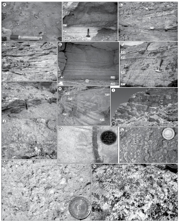
Figure 4: Examples of lithofacies observed in the Castillo Formation. a) Massive, matrix supported strata (lithofacies LF1). Clasts that lack vertical gradation in sizes and show angular-to-rounded shapes. The pen is 0.13m long. b) Massive, matrix supported strata (lithofacies LF1) in sharp, non-erosive contact with finelylaminated tuffs (lithofacies LF12). The hammer is 0.3 meters long. c) Superimposed cycles of channel fill separated by erosional surfaces (indicated by dotted lines) as part of a multistorey, low-sinuosity sandbody (lithofacies association LA3). The lower packages are composed of coarse-grained sandstones with lowangle cross-bedding (lithofacies LF5). The upper package is coarser-grained; it has a boulder-to-cobble basal lag containing tuffaceous clasts up to 20 cm in diameter and trunk fragments. The hammer (arrow) is 0.3m long. d) Trough cross-bedded tuffaceous sandstones (lithofacies LF6), observed in a normal view to the palaeoflow. Each side of the compass (arrow) is 8 cm long. e) Parallel-laminated tuffaceous sandstones (lithofacies LF4) as part of the infill of a sheetflood complex (Lithofacies association LA4)covering interbedded coarse and fine tuffaceous sandstones (lithofacies association LA2). Note the lack of a basal lag and vertical variations in the thickness of laminae in the upper package. The coin is 13 mm in diameter. f) Channelized sheet facies association (LA4) dominated by parallel-laminated sandstones (lithofacies LF4). g) Medium-grained sandstone bed of lobate geometry (lithofacies LF9) encased in poorly-exposed, tabular tuff strata (lithofacies LF11). The hammer is 0.30m long. h) Plane-laminated tuffacepus strata (lithofacies LF14) interbedded with low-angle cross-bedded tuffaceous beds (lithofacies LF15) in a poorly-channelized sheet facies association (LA6) representing the reworking of ash-fall strata. The strata have low-amplitude and high wavelength, with shallow scours at their bases. The hammer is 0.30m long. i) Tabular tuffaceous strata (LF11) associated with deposition in a distal floodplain environment (lithofacies association LA1). A person for scale (encircled). j) Densely-packed accrettionary lapilli in vitric tuffs, their cores are strongly altered by Fe-oxides (diagenetic). The coin is 13mm in diameter. k) Primary and low-order lateral root traces (rhizoliths) in grey, massive strata. Slightly decoloured drab haloes around roots represent Fe and Mn depleted areas. The coin is 13mm in diameter. l) Monoespecific cluster of back-filled, meniscate burrows attributed to Taenidium. The transversal section show near-cylindrical burrow shapes. The coin is 13mm in diameter. m) Pumice-rich tuffaceous strata from Las Pulgas area. The pumice fragments have been diagenetically altered and partially disaggregated. The coin is 13mm in diameter. n) Low-relief, asymmetrical ripples with nearstraight crest lines on top of white, fine-grained ash strata (lithofacies LF12). The side of the compass in the upper right margin of the picture is 8 cm long.

Figure 5: Detailed sedimentological logs of the Castillo Formation, with indication of lithofacies and lithofacies associations. a) Detailed outcrop section of the Castillo Formation at Tronador Canyon (Region 1). Notice the fine grainsize of the Castillo Formation and the lack of well-developed sandstone beds. b) Detailed outcrop section of the Castillo Formation from the Sierra del Castillo anticline. c,d) Detailed stratigraphic logs of the Castillo Formation in the Sierra Silva anticline. Deeply bioturbated, fine-grained ash beds are randomly interbedded with coarse-grained sandbodies that represent low-sinuosity fluvial channel deposits, sheetflood deposits or mudflow deposits. See Fig. 3 for location of the stratigraphical sections and references.
LA1. Tabular tuffs and reworked tuffs: subaerial floodplains and ephemeral ponds
Description: This lithofacies association refers to clay-sized to very-fine grained vitric ash beds that constitute up to 70% of the unit in all the study locations (see below). Individual strata range from tens of centimetres to more than 1,5 metres thick, and can be traced laterally by hundreds to thousands of meters; their stacking conforms aggradational successions of several tens of meters thick (Fig. 4i). It is either characterized by the occurrence of white-to pale green, tabular tuff beds containing fossil traces (Fig. 4l), root traces, asymmetrical ripples and core-type accretionary lapilli (Fig. 4j) (lithofacies LF11) or by thin tuff beds that preserve symmetrical ripples (Fig. 4n), debris plant and coal remains (lithofacies LF12). Fossil traces assigned to Planolites and Palaeophycus are preserved on bedding surfaces; vertical, cylindrical burrows were attributed to Skolithos. Rarely, meniscate, backfilled traces attributed to Taenidium and insect pupation chambers were identified. Patches of plane-laminated tuffs (lithofacies LF14) were found. Strata could also contain vertically-oriented rhizoliths up to 0.3 m deep, pale grey mottling or desiccation cracks on bedding surfaces. Rhizoliths (Klappa 1980) are frequently replaced by iron oxides with yellow-brown colour; they show grey and red rims with circular cross sections (Fig. 4k). Paleosoils show no development of any typical or diagnostic horizon, but in the Sierra del Castillo and northward exposures the presence of carbonate concretions is relatively common (Bellosi et al. 2002). Interbedded sandstones and tuffs preserved in the Sierra del Castillo contain internal moulds of molusks of the Curbiculoidea Superfamily, and gastropods that belong to Viviparidae Family (Caenogastropoda) and to Physidae (Pulmonata) (Lazo et al. 2011).
Interpretation: The fine grainsize of ash particles suggests a distal volcanic source for the pyroclastic materials (Walker 1971). Their preservation as tabular, very extensive beds indicates a general low-relief floodplain environment. Plane laminations in tuff strata are due to primary deposition or they can reflect reworking by air currents or floods. The occurrence of accretionary lapilli is due to contemporary rains in the basin during pyroclastic ash-fall events (Fisher and Schmincke 1984); in distal volcaniclastic environments it is a feature only preserved in the subaerial floodplain, due to destruction of non-welded ash-aggregated particles by water (Cas and Wright 1987). The rhizoliths evidence colonization of the substrate during periods of reduced sediment supply; red and grey rims around the rhizoliths were formed as result of Fe- and Mn- depleted areas by fluctuating soil-moisture (Kraus and Hasiotis 2006). Common mottling of the bioturbated sediment and occurrence of carbonate concretions also indicate fluctuation of the water table (Retallack 1990). The lack of distinctive horizons in paleosoil profiles and pyroclastic parent material allows classifying the paleosoils as andisoils, entisoils or inceptisoils. The ocurrence of Taenidium isp. is attributed to the displacement of worms in dried substrates (Bromley 1990, Minter et al. 2007), a process also evidenced by the occasional occurrence of desiccation cracks on bedding surfaces. This lithofacies association mainly represents a subaerial floodplain environment, although subaqueous environments are inferred in tuffaceous strata that preserve oscillatory or current ripples, coal fragments and fine organic debris. Such features were likely developed in poorlydrained, ephemeral ponds, reflecting the formation of standing bodies of water laterally adjacent to the fluvial sandbodies. The single bioclastic association identified in Sierra del Castillo represents a very shallow, lacustrine environment (Lazo et al. 2011).
LA2. Thin-bedded sandstone and tuff alternations: proximal floodplain
Description: This lithofacies association is characterized by moderately-sorted, coarse to very-fine grained tuffaceous sandstones interbedded with silt- to clay-sized ash beds that represent less than 5% of the thickness of the measured sections (see below). Tuff strata that integrate this lithofacies association are tens of centimetres thick and show tabular appearance, they are generally massive due to intense burrowing by Planolites or Skolithos, or they could contain parallel-lamination (lithofacies LF11). The coarser-grained component ranges from 10 cm up to 80 cm thick, mostly forming fining-upward sequences of parallel-laminated or cross-bedded strata (lithofacies LF4, LF5, LF6, LF9; Table I) with occasional preservation of asymmetrical ripples at their tops (lithofacies LF8) and burrowing (lithofacies LF10). The sandstone and tuff alternations occur in three distinctive arrangements: (a) tuffaceous sediments and sandstone bodies can display a sheet-like geometry with medium to fine-grained sandbodies of plane base and convex-upward top (Fig. 4g), integrated by lithofacies LF4, LF5, LF8, and rarely by lithofacies LF1, (b) thinly laminated (1 cm to 10 cm) alternations of nonerosive, sheet-like sandstone (lithofacies LF4, LF8) and tuff alternations that thicken- upward in vertical sections, and (c) tabular tuff beds (lithofacies LF11) locally dissected by coarse to fine-grained sandstones with erosive, concave-upward basal boundary and ribbon geometry, integrated by lithofacies LF5, LF4 and rarely by lithofacies LF1.
Interpretation: A proximal floodplain environment is inferred due to the alternation of fine-grained lithologies, the small scale of the interbedded sandstone bodies and their spatial association with fluvial channels (Fig. 5b and Fig. 6). The deposition of silt- to clay-sized ash beds occurs from suspension in a lowenergy environment as a result of primary pyroclastic deposition, or by later reworking by water during floods. Some fine-grained tuffs can also be provided by air-currents. The interbedded sandstone strata reflect periods of increased sediment supply to the floodplain, likely associated to floods. Lobate bodies were deposited from unconfined flows during high-discharge events (Smith et al. 1989) as crevasse-splays. Massive sandstone also evidences rapid deposition. Thinly laminated sandstone and tuff beds represent overbank sedimentation, in which coarsening-upward successions reflect the increase in the involved flows arriving at a low-energy environment (Smith et al. 1989), and fining-upward trends are related to the increase in the distance to a main fluvial channel or the gradual decrease in the flow conditions (Jones and Hajek 2006). Scoured-based sandbodies are interpreted as crevasse channels, formed as a result of the crevassing of a major river channel (Coleman 1969, Mjos et al. 1993, Farrell 2001)

Figure 6: Features of the proximal floodplain and fluvial channel lithofacies associations. Thickening-upward alternation of tuffaceous strata and fine-grained sandstones (lithofacies association LA2) below a multi-storey, low sinuosity fluvial channel (lithofacies association LA3). Notice the sharp basal surface of the overlying sandbody and the alternation of bioturbated, fine-grained sandstones with ash-fall strata. Each storey of the multistorey channel fill is indicated by dotted lines. Flow is from right to left. The width of the picture is 30m.
LA3. Cross-stratified, sheet-like sandstones and conglomerates: low-sinuosity and braided fluvial channels
Description: This lithofacies association includes poorly-sorted conglomerates and very coarse- to fine-grained sandstone beds that conform ungraded or finingupward successions up to 9.5 m thick. The base of this lithofacies association is a channel-shaped scour surface upon which pebble to cobble-sized clasts up to 20 cm are concentrated. The infill of this lithofacies association either consist of a unique channel fill succession with 1-2 m thick and 30-80 m wide, or a number of nested channel fills that are up to 9.5 m thick and ~ 230 m wide, separated each other by scour surfaces (Fig. 4c). Strata are poorlysorted, and contain mainly low-angle and trough cross-beddings (Fig. 4d) (LF5 and LF6, respectively), parallel-lamination (lithofacies LF4) and minor planar crossbedding (lithofacies LF7). At the base, lithofacies LF1 can be found. Upper reaches of the sandbodies can contain trails, root traces, mottling and burrows (lithofacies LF10). Burrows are simple, and unbranched. They have unlined walls and show massive or meniscate fills. Paleocurrent measurements in single channel fills are unimodal and generally show low dispersion (< 30 % around the main vector). Although many sandbodies lack of clear macroscale inclined strata set (sensuBridge 1993b), two main types of large scale low-angle-inclined bounding surfaces were identified in normal views to the paleocurrent directions of channel-fills.
(i) The most common type consists of several inclined surfaces (<10°) up to 0.5 m thick and 20 m wide defining sandstone bodies of lobate geometry, preserved on a single margin of the channel-fills (Fig. 7), with low-angle dips (<30°) to associated cross-bedded structures; and (ii) convexupward bounding surfaces up to 1.2 m thick and 25 m wide, that dip in opposite direction toward adjacent channel-fills on both sides; large-scale bounding surfaces have high-angle dips (>65) to the paleocurrents obtained from the channel-fills. Interpretation: The occurrence of fluvial channel bars and fill is interpreted because of the presence of a concave-upward basal surface, lenticular to sheet-like geometries, a coarse-grained infill that fines upward, unidirectional paleocurrents, and the lack of marine or lacustrine fossils. Most of the infill of the channels evidences the migration of subaqueous dune forms, such as 3-D dunes (lithofacies LF6), 2-D dunes (lithofacies LF7) and low-relief duneforms (LF5). Interbedded strata containing parallel-lamination (lithofacies LF4) are suggestive of increasing discharge conditions, and sediment transportation in upper flow regime conditions during floods. The stages of increased sediment supply are also evidenced from the occurrence of matrixsupported conglomerates and sandstones (lithofacies LF1). Trails and burrows on top of the channel-fills are consistent with the final abandonment of the fluvial channel and the formation of a temporally, very shallow water body. The infilling styles of the fluvial channels allow us to recognize (i) single-thread channel fills, interpreted due to the lack of internal erosion surfaces and the uniformity of cross-sets of the channel fills (Lunt et al. 2004), and (ii) multi-storey and multilateral channel fills, that show well defined basal and internal erosional surfaces, vertical stacking of fining-upward cross-sets, and channel dimensions that reflect lateral shifting and reoccupation of channels that were significantly narrower than the resulting channel sandbody.

Figure 7: Schematic representation of a multi-storey, low-sinuosity fluvial channel (Codo del Senguerr anticline section). The lower packages show several large-scale inclined surfaces at bases of coarse-grained stories that fine upward. The upper part of the channel fill shows a slightly aggrading, single-channel stage with well developed alternate bars (AB) and finer grainsize. Paleoflow reading is represented by encircled arrows. The north is at the top of the figure. The detailed vertical section (inset) shows a typical lithofacies succession of the fluvial channel lithofacies association.
The fluvial channel lithofacies association can also be characterized by its internal architecture in (i) low-sinuosity fluvial channels, interpreted due to the preservation of downstream migrating macroforms located in the margin of the active channel fills and low paleocurrents spread in individual channels, that suggest relatively straight flow paths, providing evidence for the low sinuosity of the channels (Bridge et al. 2000). The absence of lateral accretion surfaces also implies that the channels were laterally stable (Bridge 2003), or that the regional depositional dip was relatively important. Secondly, (ii) braided channels, interpreted by the identification of laterally adjacent channel fills with convex-upward, largescale inclined strata, interpreted as braid bars (Bridge 2003). Braided sandbodies represent a minor proportion of the fluvial channel lithofacies association.
LA4. Parallel-laminated conglomerates and sandstones: sheetfloods
Description: This lithofacies association is composed of coarse to fine-grained sandstone beds that are up to 2.5 m thick and 600 m wide. The basal surface can be either a scour surface covered by pebblesized clasts, or a nearly flat surface that lacks of a basal lag (Fig. 4e and Fig. 4h). Commonly associated lithofacies include coarse- to medium-grained sandstone beds with horizontal lamination (lithofacies LF4) and low-angle cross bedding (lithofacies LF5) on scour surfaces (Fig. 8). Massive, coarse-grained lenses constituted by fine gravel clasts (lithofacies LF1) or isolated, outsized pebble clasts can be found. Most of the sandstone strata are finely laminated, with differences in grainsize between laminae and they could contain very-low angle scour surfaces that separate packages where individual laminae can be traced laterally by several meters (Fig. 4f). Paleoflow direction shows very low dispersion of measurements (StD<15°). Locally, convolute lamination and carbonate concretions were observed. Most of the sheet-like sandbodies (sensu Friend et al. 1979) develop scouring at the bases and margins, and have a width/thickness ratio between 50 and 100; but thinner sandbodies can be broad sheets (Gibling 2006) of plane base with a width/thickness ratio of up to 200. Commonly, there are burrows in the upper part of the sandbodies (lithofacies LF10).
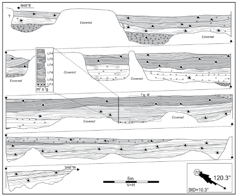
Figure 8: Line drawing of a sheetflood complex (Codo del Senguerr anticline section). Individual laminae can be traced laterally for meters, and they can be associated with low angle crossbedding. Low relief, scour surfaces separate packages with differences in grainsize and internal arrangement of sedimentary structures. Note the low dispersion in the paleocurrent. The detailed vertical section (inset) shows a typical lithofacies succession of the sheetflood deposits.
Interpretation: Sheetflood deposits record the flashy nature of the discharge of the fluvial system, through deposition of unchannelized flood waters across the alluvial plain (Friend 1983, Graf 1988). The dominance of horizontal lamination in the infill reflects dominant bedload transport (Hampton and Horton 2007), the occurrence of shallow, highenergy flow conditions, and vertical aggradation of the substrate (McKee et al. 1967, Tunbridge 1981). The transportation of particles took place in an upperto- transitional flow regime during highdischarge events (Fielding 2006) with minor reworking and generation of lower flow regime structures (lithofacies LF5) during waning flows. The lack of other typical sedimentary structures of lower flow regime (e.g. asymmetrical ripples) is due to the general coarse grainsize of the deposits (> 0.7 mm), but it could also be due to high concentration of coarse ash fragments carried in suspension into the flow, which could suppress the flow separation and reduce the turbulence (Allen and Leeder 1980, Bridge and Best 1997). Soft-sediment deformations indicate rapid dewatering, probably due to quick accumulation of the sand (Allen 1977). Most of their features are preserved in actual ephemeral fluvial systems in arid (Bromley 1991, Tooth 2000) or semi-arid (Turbeville 1991) regions.
LA5. Massive conglomerates and sandstones: subaerial debris-flow deposits
Description: This lithofacies association is composed by cobble to pebble-sized tuffaceous conglomerates and sandstone beds up to 3.5 m thick and 100 meters wide, but most of them are less than 1 m thick and a few tens of meters wide. They frequently have a slightly irregular to planar base (Fig. 4b). The infill of these sandbodies is matrix supported, it has a bimodal grainsize distribution and could show slightly fining-upward trends. The matrix is composed of fine to medium-grained tuffaceous sandstones; larger clasts consisting of variably-rounded gravel clasts ranging in size from 0.5 to 10 cm. They lack any preferred orientation (Fig. 4a) or they can be slightly imbricated, sometimes found in upper reaches of the sandbodies. Most of the strata are constituted by massive conglomerates (lithofacies LF1) or inversely graded (lithofacies LF2) conglomerates and sandstones; few sandbodies preserve parallel-laminated sandstones (lithofacies LF4) and low-angle cross bedding (lithofacies LF5) on top. Trails, vertical burrows and mud cracks are also common on upper reaches (lithofacies LF10).
Interpretation: Poor sorting, coarse grainsize, massive appearance and general lack of current structures evidence transportation and rapid deposition (Smith 1987a, Smith 1991) from a cohesionless, subaerial debris-flow (Nemec and Steel 1984). The small scale of the involved sandbodies, coarse grainsize and internal features are consistent with the transportation in a gravity-driven catchment, suggesting a local source of detritus and the reworking of pyroclastic material as a result of heavily sediment-laden stream floods. High concentration of particles in the flow avoids the development of structures typical of dilute flows (e.g. ripples and cross bedding) due to suppressed turbulence in the flow (Fisher 1971, Martin and Turner 1998). Dilution by stream water is interpreted by the occurrence of current structures (Alexander and Fielding 1997) and finer lithologies upward (Fig. 5d). Mud cracks record desiccation of the bed surface after flood events (Collinson 1996).
LA6. Lenticular tuffs: reworked ashfall beds
Description: This lithofacies association consists of isolated lenses of clay to finegrained reworked tuff beds that are up to 0.7 m thick and 15 m wide. Its deposits are interbedded with packages of tabular tuffs of tens of meters thick (LA1 lithofacies association). Erosively-based, these lithofacies show poorly defined lateral boundaries with deposits of LA1. Massive appearance of fine-grained particles is the most common feature (lithofacies LF12), with random alignment of variably-rounded tuffaceous or (rarely) pumice clasts of up to 1 cm in size (Fig. 4m). Parallel laminated reworked tuffs (lithofacies LF13) and lowangle cross-bedded reworked tuffs (lithofacies LF14) can be found in low proportion in the infill.
Interpretation: Massive strata suggest en masse sedimentation (Best 1992). ParaFluvial reworking of volcaniclastic particles. 49 llel-laminated strata and low-angle crossbedding are produced by vertical aggradation of the substrate during transitional to upper flow-regime stages in fast-flowing, shallow waters (Smith and Lowe 1991). The fine-grained size characteristic and its relation to association LA1 are suggestive of local reworking of ash-fall beds during heavy rains in small-scale depressions of the floodplain.
SPACIO-TEMPORAL VARIABILITY
The seven study locations selected for this study of the Castillo Formation in the San Bernardo Fold Belt cover ca 150 km in a N-S direction (Fig. 1). Along this belt the Castillo Formation shows a systematic southward increase in its thickness (Fig. 3). Although the overall proportion of coarse- grained lithofacies associations (LA3 + LA4 + LA5 + LA6) is quite similar among the study locations (Fig. 9a), there are systematic variations in their relative proportion among them (Fig. 9b). Except for the sheetflood complexes, the sandbodies increase their thickness southwards (Fig. 10). On the other hand, log-log plots of W/Th data of coarse-grained sandbodies from three selected study locations show no significant changes in the averaged external shape, and further analysis of these values will be given below. The interpretation of the spatial organization of lithofacies associations and the thickness of fluvial sandbodies have been integrated into an overall depositional model. The reworking of pyroclastic particles took place mainly in a low-gradient fluvial basin, with several varieties of fluvial sandbodies; coeval lacustrine facies should be mainly preserved in the subsurface of the basin (e.g. Uliana and Legarreta 1999, Hechem and Strelkov 2002).

Figure 9: a) Spatial variation in proportion to the lithofacies associations of the Castillo Formation. The proportion of coarse-grained sandbodies (LA3+LA4+LA5+LA6) and proximal floodplain deposits (LA2) is quite similar along different areas, with the exception of the northern basin-margin location (Region 1), where only deposition of ash-fall strata (LA1) is preserved. b) Spatial changes in the proportion of coarse-grained sandbdodies of the Castillo Formation from exposures at the basin margin (Region 1) to the southern San Bernardo Fold Belt (Region. 4). Data show dominance of sub-aerial mudflow deposits (LA5) and sheetflood deposits (LA4) in low-subsidence areas (e.g. Region 2), and dominance of low-sinuosity fluvial sandbodies (LA3) in southern study locations (e.g. Region 4), where higher subsidence rate values occurred. In intermediate study locations (e.g. Region 3) there is a tripartite subdivision of fluvial styles.

Figure 10: Comparative plots for different types of coarse-grained sandbodies (LA3, LA4, LA5 and LA6) of the Castillo Formation among studied locations. Statistical variations are presented as box diagrams. Following convention, the box defines the area between the 25th and 75th percentiles and the centre line represents the median. For a population with less than 4 points, the box is omitted and the centre line represents the median (n=3) or maximum thickness (n=1). Except for the sheetflood complexes, the sandbodies show an increase in their thickness in the southern exposures. Braided fluvial channels are extremely rare in the unit.
At the northern basin-margin exposures (Region 1: Tronador Canyon) the succession is dominated by amalgamated ash-fall beds (LA1) that were deeply burrowed in subaerial conditions, with extreme condensation of the sedimentary record and the lack of coarse-grained lithofacies associations (Fig. 8a). The occurrence of small-scale sandbodies mainly associated to debris-flows (LA5) or sheetflood processes (LA4) as those mainly preserved in the northern part of the study area (Region 2: Sierra Nevada and Sierra del Castillo anticlines) (Fig. 9b) is indicative of variable and episodic delivery of water and volcaniclastic particles in a poorly-integrated network of fluvial channels. Such processes of fluvial resedimentation occurred probably during short-lived periods of seasonal, high-discharge events. Thus, the highly changing behaviour of the fluvial system in these study locations is likely a response to temporal variability in precipitations, which favours the development of a channel network that is not in equilibrium with their slopes or discharge conditions. Fully lacustrine conditions were infrequent, but ocassionally occurr. A quite similar situation can be interpreted for the fluvial system preserved in areas of increasing subsidence (Region 3: Sierra Silva and Las Pulgas anticlines) due to the common occurrence of subaerial debris- flows (LA5) and sheetfloods (LA4). However, the increase in the proportion of low-sinuosity fluvial channels (LA3) and the larger scale of the coarse-grained sandbodies suggest a more integrated drainage network. The fluvial succession preserved at the southernmost part of the San Bernardo Fold Belt (Region 4: Papelía and Codo del Senguerr anticlines) was preserved in an area of higher relative subsidence. Sub-aerial debris-flows are absent and sheetflood deposits are scarcely represented (Fig. 9b); most of the fluvial channels are of lowsinuosity and they evidence the development of a perennial and well-integrated network of channels probably draining larger catchment areas located westward.
CONTROLS ON THE SEDIMENTARY EVOLUTION
Changes in the characteristics of the Castillo Formation are related to the variable importance among four main controls: tectonics, base level changes, climate and pyroclastic supply.
Tectonics: The deposition of the Castillo Formation has been produced during a period of reduced tectonic activity, which is evidenced by the dominance of cakelayer successions and gradual thickness variations at regional scale (Fitzgerald et al. 1990, Fig. 2). However, the tectonic control occured due to the identification of high-angle, synsedimentary normal faults in the subsurface (Figari et al. 1999, Cayo et al. 2011, Paredes et al. 2013) and at outcrops. The synsedimentary faults observed in the Codo del Senguerr anticline are high-angle (> 70°) normal faults with Az of 120-145° and a dip-slip displacement of tens of centimetres to a few meters (Fig. 11). The normal faults show thickness variations across fault planes, upward reduction in the dip-slip displacement, and the presence of small-scale domino-faults with displacement of a few centimetres. Paleocurrent measurements in the Codo del Senguerr anticline show a consistent paleoflow direction toward the southeast (mean: 117°, n=1487; StD=16°), parallel to the orientation of the Early Cretaceous normal faults mapped in the subsurface of surrounding areas (Homovc et al. 1995), suggesting the occurrence of tectonically controlled, longitudinal valleys. The strong positive inversion of the San Bernardo Fold Belt and extensive flood basalts of Neogene age avoid further analysis of tectonic controls on the sedimentation at outcrops.
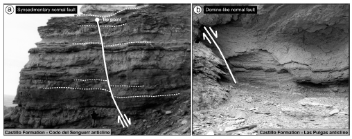
Figure 11: Synsedimentary faulting during the deposition of the Castillo Formation. a) High-angle, synsedimentary normal fault. The geologist is 1.90m tall. Note the vertical reduction in fault displacement and the changes in thickness across the fault plane. b) Small-scale domino fault system preserved in the fault zone of a major extensional fault. The pen is 0.14m long.
Base-level changes: Major relief at the base of multi-storey systems and the presence of mature interfluve paleosoils are commonly considered to be strong evidence for significant base-level falls and the presence of sequence boundaries (Van Wagoner et al. 1990). Neither feature has been identified in the analyzed outcrops; the lack of significant coeval lacustrine successions also prevents the analysis of basinward facies shift. Based on the section of Cerro Colorado de Galveniz, Umazano et al. (2012) identified three depositional system tracts in the Castillo Formation following the criteria proposed by Legarreta et al. (1993) to relate base- level shifts using the vertical variation in the proportion of channel belts and floodplain fines, and defining "foresteeping", backsteeping" and "aggradational" system tracts (sensu Legarreta et al. 1993). Although this approach is valid for fully continental succesions, its applicability using a single section is speculative and the results can be of local character, with no relation to contemporary baselevel shifts.
Mid-Cretaceous climate: The influence of the climate has been commented above in the development of the depositional model of the Castillo Formation. Additionally, data from this study can be integrated to the sparse data of the Mid-Cretaceous climate of the Golfo San Jorge basin in Central Patagonia. The Lower Cretaceous Matasiete-Pozo D-129 depositional system shows some evidences that point to a semiarid environment, such as the presence of Classopolis pollen, the common occurrence of oolitic grainstones and Botryococcus-like algal forms in the lacustrine facies (Hechem et al. 1987; Van Nieuwenhuise and Ormiston 1989). The presence of vertisoils and the abundance of carbonate concretions in floodplain facies of the Matasiete Formation (Paredes et al. 2007) also point to a semi-arid environment. In contrast, studies in the overlying Lower Bajo Barreal Formation (Archangelsky et al. 1994) evidence humid, continental mild to warm climate during Late Albian-Cenomanian. Similar conditions have been also reported from the southernmost areas of Patagonia in the Late Albian-Cenomanian Kachaike Formation (Barreda and Archangelsky 2006). Those studies evidence that during the mid-Cretaceous a climatic shift from semi-arid environments to more humid conditions occurred in the Golfo San Jorge basin and surrounding areas of Southern Patagonia. A comparative analysis of the fluvial architecture of the Matasiete and Castillo Formations shows a noticeable reduction in the thickness and lateral extent of fluvial sandbodies of the Castillo Formation (Paredes et al. 2007, their fig. 10) and the ending of regional lacustrine deposition. Reduction in the sediment supply and discharge of the fluvial systems could be interpreted as a response to the Mid-Cretaceous climatic variation from semi-arid to more humid conditions (Schumm 1968, Schumm 1993), probably related to changes in the type of vegetation with increasing precipitation (Langbein and Schumm 1958).
Pyroclastic supply: Delivery of a large volume of pyroclastic particles during eruptions and resedimentation processes of such particles are major control on the characteristics of volcaniclastic successions preserved close to volcanoes (e.g. volcaniclastic aprons). It is generally assumed that rates of pyroclastic supply are high enough to impose major changes in the nature of the fluvial system, as can be the occurrence of braided channels during syn-eruptive or early inter-eruptive stages (Vessell and Davies 1981, Smith 1987a, Smith 1987b, Smith 1991, Best 1992, Nakayama and Yoshikawa 1997, Kataoka and Nakajo 2002). In the Golfo San Jorge basin, the two-stage model first proposed by Smith (1991) has been tested by Umazano et al. (2008a) and Umazano et al. (2012); in their studies they have found no systematical relations between channel patterns or fluvial styles and the occurrence of inter-eruptive and syn-eruptive stages, evidencing a nonpredictable behaviour of the fluvial system with volcanic activity. A distinctive feature of the Castillo Formation is the unusual occurrence of braided channels, being only recognized in the southernmost part of the study area (e.g. Region 4) as a subordinate style. Scarcity of braided channels implies that the deposition of pyroclastic particles as ash-fall material delivered to fluvial channels never exceeded the in-channel threshold for aggradation, suggesting an equilibrium between the rate of pyroclastic supplies and the rate of aggradation during eruptions. Furthermore, volcaniclastic units in distal environments that contain braided channels could not have a direct relation with the activity of volcanic centres, because the aggradation and supply of ash to the receiving basin could have occurred long time after the ending of the eruptive event, so the braided style could have no temporal relationship with eruptions. Facies studies in the Castillo Formation (Umazano et al. 2012) advocated the occurrence of debris flow processes to the collapse of volcanic edifices, removilization of primary pyroclastic deposits by intense rains or snow melting. Our data indicate that debris-flow deposits of the Castillo formation are dominant in the unit toward the north of the study area (Fig. 9b), where they mainly occur in small-scale channels (Fig. 10), with no evidence of a large-scale drainage network that could transport detritus from the Andes, located up to 190 km westward. From this, we consider that most of the debris-flow deposits are associated with local sources, inference that is consistent with the lack of welded ignimbrites or any other evidence of transportation- removilization of particles by hot (pyroclastic) flows. Although there are several papers (Mothes et al. 1998, Manville et al. 2009) that have demonstrated the transportation of volcaniclastic particles by a mixture of dusty gas and hot water for distances up to 100 kilometers from the source, the transpotation of particles in hot conditions has not been proven, and the inferred relief of the volcanic arc coeval with deposition of the Castillo Formation should be significatively lower to those analized by Mothes et al. (1998), where volcanic ediffices are about 3,000 m above sea level. Thus, in spite of the importance of the volcaniclastic participation in the composition of the floodplain and channel infill, a direct link between the activity of the volcanoes in the Andes and the dynamics of the fluvial system is still unproved. We advocate the idea that the occurrence of extensional tectonics coeval with deposition of the Castillo Formation has favoured the creation of intrabasin highs that promote processes of removilization of volcanic particles in small-scale, partially isolated basins bounded by local threshold, as has been demonstrated by Cayo et al. (2011) and Paredes et al. (2013) in the subsurface of the basin. In this scenario, intense rains favoured reworking of coarse grained particles in small-scale channel belts (Fig. 12). The field information collected during this research does not support regional drainage systems that directly transport volcaniclastic particles from proximal volcaniclastic sources.
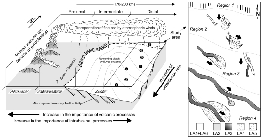
Figure 12: Conceptual cartoon showing the depositional model of the Castillo Formation in the San Bernardo Fold Belt. Ash fall beds provided from the Andean Ranges were reworked in a low-gradient fluvial basin that shows an increase in contemporary subsidence in the southern part of the study area. Volcaniclastic resedimentation processes were mainly related to small-scale, subaerial mudflows and sheetfloods in areas of low subsidence (e.g. Region 2), and to low sinuosity fluvial channels of larger scale and sheetfloods in areas of higher subsidence (eg. Region 4). General direction of paleoflow in study locations is indicated by arrows.
Application to hydrocarbon exploration
Integration of 3-D seismic surveys, welllogs and cores allows us to cover different scales of observation of geological features during exploration and the development of oil fields. 3-D seismic data can provide detailed images of the planform geometry of fluvial channels (e.g. Posamentier et al. 2007, Ethridge and Schumm 2007). Electric well logs and cores allow a reliable recognition of drilled sandstone bodies, their internal heterogeneities, vertical arrangement of lithofacies and lithofacies associations, and petrophysical data. However, to define the volume of hydrocarbons that can be recovered from a single reservoir; the real lateral extent of the potential reservoir must be obtained from seismic data or from the analysis of correlatable outcrop sections.
The Castillo Formation is currently a risky hydrocarbon reservoir in the Golfo San Jorge basin. Uncertainty is due to the presence of oil-bearing reservoirs that are about 3 m thick, below the available vertical resolution of seismic surveys (~ 20 m), and by the abundance of volcaniclastic particles in channel sandbodies and floodplain areas, making it difficult for us to identify the reservoirs using electric welllogs. Another intrinsic source of uncertainty is due to the lateral extent of the potential oil-bearing reservoirs, which are mainly smaller than 215 metres (Fig. 10, Fig. 13). Such a limited lateral extent avoids a reliable correlation of potential reservoirs between well logs of productive wells, which are frequently separated 250- 300 m from each other; but on the other hand this implies that a large number of coarse-grained volcaniclastic sandstones has not been drilled yet using the current well-to-well separation. Published data on the dimensions of the sandstone bodies of the Castillo Formation correspond to Bridge et al. (2000) and Umazano et al. (2012). The former authors analyzed the southern side of the Senguerr river elbow identifying single and multi-storey, low-sinuosity sandbodies draining to the SE (125º) with a mean thickness of 3.62 m, a mean lateral extent of 176 m and a mean W/Th ratio of 53 (n=27). Umazano et al. (2012) provided average thickness values of channel belts from Cerro Colorado de Galveniz (n=19; Average Th= 2.73 m) and Cañadón Puerta del Diablo (n=11; Average Th= 1.86 m). The average data from measured sandbodies at Codo del Senguerr anticline indicate a mean thickness of 2.89 m (StD= 1.59 m); the mean lateral extent of the sandbodies is 114 m, with StD of 101 m (n=86). The W/Th ratio of these sandbodies evidence that most of the fluvial channels are narrow sheets (Gibling 2006) with an average W/Th ratio of 42 and an StD of 38 (Paredes 2009). The W/Th data compilated in this study from the outcrop sections exposed in different geographical and geological areas of the basin (e.g. Region 2 to Region 4) show that although there are clear changes in the infill styles of fluvial sandbodies, their average W/Th ratio does not change significantly, having mean values around 40-47 in the studied locations (Fig. 13). Such relations, although limited to the analysis of a few hundred fluvial sandbodies and with the shown statistical variations, are the first quantitative data obtained from outcrops and could help to define more accurate prediction of efficient well spacing, improving capital investment projections and field economics.

Figure 13: Log-Log width to thickness ratio (W/Th) plots for different types of coarse-grained sandbodies from Region 2 (Sierra del Castillo anticline), Region 3 (Sierra Silva anticline) and Region 4 (Codo del Senguerr anticline). Statistical variation of thickness, real lateral extent and W/Th ratio are shown.
CONCLUSIONS
The Albian Castillo Formation of the Golfo San Jorge basin in the San Bernardo Fold Belt represents the distal reworking of volcaniclastic particles from the Andes in a fluvial basin. About 3.500 m of detailed measured sections and 284 descriptions of fluvial channels were carried out in seven main study locations that include exposures from the northern basinmargin to the most complete exposures at the southernmost San Bernardo Fold Belt, covering ca 150 km in an N-S direction. The fluvial succession comprises fifteen lithofacies that were integrated in six main lithofacies associations: (i) subaerial floodplains and ponds; (ii) proximal floodplain deposits; (iii) low-sinuosity and braided fluvial channels; (iv) subaerial debrisflow deposits; (v) sheetflood deposits; (vi) reworked ash-fall beds.
Depending on the differential subsidence of the basin, the spatial variations in the proportion of the recognized lithofacies associations and the thickness of the coarse-grained sandbodies, four main Regions can be identified (named 1 to 4). At the northern basin-margin (Region 1) the 31-m thick section consists of an aggradational succession of fine-grained ashfall beds with presence of core-type accretionary lapilli, variable pedogenesis and the lack of coarse-grained deposits, reflecting condensation of the sedimentary record. In areas proximal to the northern basin-margin (Region 2) the succession is less than 300 m thick and consists mainly of small-scale subaerial debrisflow deposits and sheetflood deposits, evidencing a poorly integrated network of channels and a great variation in discharge. In the southern areas (Region 3) the unit is 300-500 m thick and it is characterized by thicker fluvial sandbodies, where alternation of subaerial debrisflow deposits, sheetflood deposits and low-sinuosity fluvial channels reflects a highly variable fluvial dynamics. In areas of high-subsidence at southern San Bernardo Fold Belt (Region 4) the unit is up to 800 m thick and the fluvial sandbodies are of low-sinuosity style, mainly single or multi-storey, as part of a well integrated drainage network, in which great variations in discharge are evidenced by sheet-flood deposits.
Analyzed sections of the Castillo Formation are outcrop analogs of the oil-bearing succession preserved in the subsurface of the basin. The detailed data set of thickness and real width obtained from channels and channel belts show predictable patterns of change in the thickness and lateral extent of the coarse-grained sandbodies, with W/Th values around 40-47. The importance of determining channel-body shapes, relations between the thickness and real width of the coarse- grained sandbodies in fluvial successions has direct implications in the development of oil-bearing reservoirs, and it constitutes a strong tool to improve the well spacing between productive wells or the location of injection wells in enhanced recovery projects. Although almost 70% of the unit is composed of fine-grained ash-fall strata preserved in wide floodplains via ash-fall or reworked during floods, volcanic activity in the Andes appears to play a subordinate role in the evolution of the unit. The complex alluvial organization and the changes among the study locations suggest that the main features are mostly related to seasonal or episodic delivery of water and volcaniclastic particles in local or regional drainage networks linked to changes in the subsidence associated to coeval extensional tectonics.
ACKNOWLEDGEMENTS
The Facultad de Ciencias Naturales of the U.N.P.S.J.B. is thanked for logistic support. This research was partially founded by PI CIUNPAT Nº 868 (U.N.P.S.J.B.) and PICT 2012-1369 (ANPCyT-FONCyT). The manuscript reviewers (K. Kataoka and M.A. Umazano) and the editor (R.E. Giacosa) of this publication are greatly acknowledged for their extensive and very helpful comments and suggestions to improve and clarify an earlier draft of this paper.
WORK CITED IN TEXT
1. Acuña, C., Schiuma, A., Parra, D., Droeven, C., Bernedo, M. and Paredes, J.M. 2011. Modelo paleoambiental de la Formación Mina del Carmen en el Yacimiento Cerro Dragón, Cuenca del Golfo San Jorge, Argentina. 8° Congreso de Exploración y Desarrollo de Hidrocarburos, Trabajos Técnicos, pp. 419- 439. Mar del Plata. [ Links ]
2. Alexander, J. and Fielding, C. 1997. Gravel antidunes in the tropical Burdekin River, Queensland, Australia. Sedimentology 44: 327-337. [ Links ]
3. Allen, J.R.L. 1977. The possible mechanics of convolute lamination in graded sand beds. Geological Society of London, Journal 134: 19-31. [ Links ]
4. Allen, J.R.L. and Leeder, M.R. 1980. Criteria for the instability of upper-stage plane beds. Sedimentology 27: 209-217. [ Links ]
5. Archangelsky, S., Bellosi, E.S., Jalfin, G.A. and Perrot, C. 1994. Palinology and alluvial facies from the mid-Cretaceous of Patagonia, subsurface of San Jorge basin, Argentina. Cretaceous Research 15: 127-142. [ Links ]
6. Barcat, C., Cortiñas, J., Nevistic, V. and Zucchi, H. 1989. Cuenca del Golfo San Jorge. In: Chebli, G. and Spalletti, L.A. (Eds.), Cuencas Sedimentarias Argentinas, Serie de Correlación Geológica 6: 319-345. San Miguel de Tucumán, Argentina. [ Links ]
7. Barreda, V. and Archangelsky, S. 2006. The southernmost record of tropical pollen grains in mid-Cretaceous of Patagonia, Argentina. Cretaceous Research 27: 778-787. [ Links ]
8. Bellosi, E.S., Gonzalez, M. and Genise, J. 2002. Paleosuelos y sedimentación cretácica de la cuenca San Jorge (Grupo Chubut) en la Sierra de San Bernardo, Patagonia Central. 15° Congreso Geológico Argentino, Actas 2: 747- 753. Calafate. [ Links ]
9. Best, J.L. 1992. Sedimentology and event timing of a catastrophic volcaniclastic mass flow, Volcan Hudson, southern Chile. Bulletin of Volcanology 54: 299-318. [ Links ]
10. Bridge, J.S. 1993a. Description and interpretation of fluvial deposits: a critical perspective. Sedimentology 40: 801-810. [ Links ]
11. Bridge, J.S. 1993b. The interaction between channel geometry, water flow, sediment transport and deposition in braided rivers. In: Best J.L. and Bristow C.S. (Eds.) Braided Rivers. Geological Society of London, Special Publication 75: 13-71. [ Links ]
12. Bridge, J.S. 2003. Rivers and Floodplains: Forms, Processes and Sedimentary Record. Blackwell, Oxford, 491 pp. [ Links ]
13. Bridge, J.S. and Best, J.L. 1997. Preservation of planar laminae due to migration of low-relief bed waves over the transition from dunes to upper-stage plane beds: comparisons of experimental data with theory. Sedimentology 35: 753-763. [ Links ]
14. Bridge, J.S., Jalfin, G.A. and Georgieff, S.M. 2000. Geometry, lithofacies, and spatial distribution of Cretaceous fluvial sandstone bodies, San Jorge Basin, Argentine: outcrops analog for the hydrocarbon-bearing Chubut Group. Journal of Sedimentary Research 70: 319-337. [ Links ]
15. Bromley, R.G. 1990. Trace fossils, biology and taphonomy. Unwin Hyman, London, 280 pp. [ Links ]
16. Bromley, M.H. 1991. Variations in fluvial style as revealed by architectural elements, Kayenta Formation, Mesa Creek, Colorado, USA: evidence for both ephemeral and perennial fluvial processes. In: Miall A.D. and Tyler, N. (Eds.) The Three-dimensional Facies Architecture of Terrigenous Clastic Sediments and its Implications for Hydrocarbon Discovery and Recovery, SEPM Concept in Sedimentology and Paleontology 3: 94-102. [ Links ]
17. Cas, R.A.F. and Wright, J.V. 1987. Volcanic successions, modern and ancient. Allen and Unwin, London, 528 pp. [ Links ]
18. Cayo, E.L., Crovetto, C.B., Plazibat, S.G., Stein, J.E., Diaz, M.T. y Paredes, J.M. 2011. Control tectónico sobre la sedimentación de la Formación Mina del Carmen en el Yacimiento Cerro Dragón, Cuenca del Golfo San Jorge, Argentina. 8° Congreso de Exploración y Desarrollo de Hidrocarburos, Trabajos Técnicos, pp. 397-418. Mar del Plata. [ Links ]
19. Chelotti, L.A. 1997. Evolución tectónica de la Cuenca del Golfo San Jorge en el Cretácico y Terciario: algunas observaciones desde la interpretación sísmica. Boletín de Informaciones Petroleras 49: 62-82. [ Links ]
20. Coleman, J.M. 1969. Brahmaputra River: Channel processes and sedimentation. Sedimentary Geology 3: 131-239. [ Links ]
21. Collinson, J.D. 1996. Alluvial sediments. In: Reading H.G. (Ed.) Sedimentary Environments: Processes, Facies and Stratigraphy, 3rd Ed., Blackwell, Oxford, pp. 37-82. [ Links ]
22. Coussot, P. and Meunier, M. 1996. Recognition, classification and mechanical description of debris flows. Earth-Science Reviews 40: 209- 227. [ Links ]
23. Dasgupta, P. 2003. Sediment gravity flow – the conceptual problems. Earth-Science Reviews 62: 265-281.
24. Ethridge, F.G. and Schumm, S.A. 2007. Fluvial seismic geomorphology: a view from the surface. In: Davies, R.J., Posamentier, H.W., Wood, L.J. y Cartwright, J.A. (Eds.) Seismic Geomorphology: Application to Hydrocarbon Exploration and Production. Geological Society of London, Special Publication 277: 205-222. [ Links ]
25. Farrell, K.M. 2001. Geomorphology, facies architecture, and high-resolution, non-marine sequence stratigraphy in avulsion deposits, Cumberland Marshes, Saskatchewan. Sedimentary Geology 139: 93-150. [ Links ]
26. Feruglio, E. 1949. Descripción Geológica de la Patagonia. Yacimientos Petrolíferos Fiscales, Tomo 1, 1-334. Buenos Aires. [ Links ]
27. Fielding, C.R. 2006. Upper flow regime sheets, lenses and scour-fills: extending the range of architectural elements for fluvial sediment bodies. Sedimentary Geology 190: 227-240. [ Links ]
28. Figari, E.G., Hechem, J.J. y Homovc, J.F., 1990. Arquitectura depositacional de las "Areniscas Verdes" de la Formación Bajo Barreal, provincia del Chubut, Argentina. 3º Reunión Argentina de Sedimentología, 1:130-138. [ Links ]
29. Figari, E.G., Cid de la Paz, M.S. and Laffitte, G. 1996. Neocomian half graben in the western San Jorge basin, Argentina: petroleum systems, origin and tectonic inversion. American Association of Petroleum Geologists Bulletin 80: 1289-1290. [ Links ]
30. Figari, E., Strelkov, E., Laffife, G., Cid de la Paz, M., Courtade, S, Celaya, J., Vottero, A., Lafourcade, P., Martínez, R. y Villar, H. 1999. Los sistemas petroleros de la Cuenca del Golfo San Jorge: Síntesis estructural, estratigráfica y geoquímica. IV Congreso de Exploración y Desarrollo de Hidrocarburos, pp. 197-237. Buenos Aires. [ Links ]
31. Fisher, R.V. 1971. Features of coarse-grained, high-concentration fluids and their deposits. Journal of Sedimentary Petrology 41: 916- 927. [ Links ]
32. Fisher, R.V. and Schmincke H.U. 1984. Pyroclastic Rocks. Springer-Verlag, Berlin. 472 pp. [ Links ]
33. Fitzgerald, M.G., Mitchum, R.M. Uliana, M.A. and Biddle, K.T. 1990. Evolution of the San Jorge Basin, Argentina. American Association of Petroleum Geologists Bulletin 74: 879-920. [ Links ]
34. Friend, P.F. 1983. Toward the field classification of alluvial architecture or sequence. In: Collinson J.D. and Lewin J. (Eds.) Modern and Ancient Fluvial Systems. International Association of Sedimentologists Special Publication 6: 345-354. [ Links ]
35. Friend, P.F., Slater, M.J. and Williams, R.C. 1979. Vertical and lateral building of river sandstone bodies, Ebro basin, Spain. Geological Society of London, Journal 136: 39-46. [ Links ]
36. Genise, J.F., Sciutto, J.C., Laza, J.H., González, M.G. and Bellosi, E.S. 2002. Fossil bee nests, coleopteral pupal chambers and tuffaceous paleosols from the Late Cretaceous Laguna Palacios Formation, Central Patagonia (Argentina). Palaeogeography, Palaeoclimatology, Palaeoecology 177: 215-235. [ Links ]
37. Genise, J.F., Melchor, R., Bellosi, E.S., Gonzalez, M.G. and Krause, M. 2007. New insect pupation chambers (Pupichnia) from the Upper Cretaceous of Patagonia, Argentina. Cretaceous Research 28: 545-559. [ Links ]
38. Gibling, M.R. 2006. Width and thickness of fluvial channel bodies and valley fills in the geological record: a literature compilation and classification. Journal of Sedimentary Research 76: 731-770. [ Links ]
39. Graf, W.L. 1988. Fluvial processes in dryland rivers. Springer-Verlag, Berlín, 346 pp. [ Links ]
40. Hampton, B.A. and Horton, B.K. 2007. Sheetflow fluvial processes in a rapidly subsiding basin, Altiplano plateau, Bolivia, Sedimentology 54: 1121-1147. [ Links ]
41. Hechem, J.J., Figari, E.G. y Musacchio, E.A. 1987. Hallazgo de la Formación Pozo D-129. Petrotecnia 28: 13-15. [ Links ]
42. Hechem, J.J., Homovc, J.F. y Figari, E.G. 1990. Estratigrafía del Chubutiano (Cretácico) en la Sierra de San Bernardo, cuenca del Golfo San Jorge, Argentina. 11º Congreso Geológico Argentino, Actas 3: 173-176. San Juan. [ Links ]
43. Hechem J.J. and Strelkov, E.E. 2002. Secuencia sedimentaria mesozoica del Golfo San Jorge. In: Haller, J.M. (Ed.) Geología y recursos Naturales de Santa Cruz. Relatorio del 15º Congreso Geológico Argentino, pp. 129-147. Buenos Aires. [ Links ]
44. Homovc, J.F., Conforto, G.A., Lafourcade, P.A. and Chelotti, L.A. 1995. Fold belt in the San Jorge Basin, Argentine: an example of tectonic inversion. In: Buchanan J.G. and Buchanan P.G. (Eds.) Basin Inversion. Geological Society of London, Special Publication 88: 235-248. [ Links ]
45. Jones, H.L. and Hajek, E.A. 2006. Characterizing avulsion stratigraphy in ancient alluvial deposits. Sedimentary Geology 202: 124-137. [ Links ]
46. Kataoka, K. 2005. Distal fluvio-lacustrine volcaniclastic resedimentation in response to an explosive silicic eruption: the Pliocene Mishuno tephra bed, central Japan. Geological Society of America Bulletin 117: 3-17. [ Links ]
47. Kataoka, K. and Nakajo, T. 2002. Volcaniclastic resedimentation in distal fluvial basins induced by large-volume explosive volcanism: The Edisutoge-Fukuda tephra, Plio-Pleisocene boundary, central Japan. Sedimentology 49: 319-334. [ Links ]
48. Kataoka, K.S., Manville, V., Nakajo, T. and Urabe, A. 2009. Impacts of explosive volcanism on distal alluvial sedimentation: Examples from the Pliocene-Holocene volcaniclastic successions of Japan. Sedimentary Geology 220: 306-317. [ Links ]
49. Klappa, C.F. 1980. Rhizoliths in terrestrial carbonates: classification, recognition, genesis and significance. Sedimentology 26: 613-629 [ Links ]
50. Kraus, M.J. and Hasiotis, S.T. 2006. Significance of different modes of rhizolith preservation to interpreting paleoenvironmental and paleohydrologic settings: examples from Paleogene paleosols, Bighorn basin, Wyoming, U.S.A. Journal of Sedimentary Research 76: 633-646. [ Links ]
51. Langbein, W.B. and Schumm, S.A. 1958. Yield of sediment in relation to mean annual precipitation. Transactions of the American Geophysical Union 39: 1076-1084. [ Links ]
52. Lazo, D., Cataldo C., Paredes, J.M., Foix, N., Allard, J.O. and Mussel, F.J. 2011. Primer registro de moluscos procedentes de la Formación Castillo, Albiano de la Cuenca del Golfo San Jorge, Patagonia Argentina. Reunión Anual de Comunicaciones de la Asociación Argentina de Paleontología, pp. 38-39. Luján, Argentina. [ Links ]
53. Legarreta, L., Uliana, M., Larotonda, C.A. and Meconi, G.R. 1993. Approaches to nonmarine sequence stratigraphy - theoretical models and examples from Argentine basins. In: Eschard, R., Doliez, B. (Eds.) Subsurface Reservoir Characterization from Outcrop Observations. Collection Colloques et Séminaires, vol. 51. Editions Technip, Paris, pp. 125-145. [ Links ]
54. Lesta, P. 1968. Estratigrafía de la Cuenca del Golfo San Jorge. 3° Jornadas Geológicas Argentinas, Actas 1: 251-289. [ Links ]
55. Lesta, P. and Ferello, R. 1972. Región Extraandina del Chubut y norte de Santa Cruz. En Leanza A. (Ed.) Geología Regional Argentina, pp. 601-654. Academia Nacional de Ciencias. Córdoba. [ Links ]
56. Lunt, I.A, Bridge, J.S. and Tye, R.S. 2004. A quantitative, three-dimensional depositional model of gravelly braided rivers. Sedimentology 51: 377-414. [ Links ]
57. Manville, V., Segschneider, B., Newton, E., White, J.D.L., Houghton, B.F. and Wilson, C.J.N. 2009. Environmental impact of the 1.8 ka Taupo eruption, New Zealand: Landscape responses to a large-scale explosive rhyolite eruption. Sedimentary Geology 220: 318- 336. [ Links ]
58. Martin, C.A.L. and Turner, B.R. 1998. Origins of massive-type sandstones in braided river systems. Earth-Science Reviews 44: 15-38. [ Links ]
59. Mathinen, M.E. and McPherson J.G. 1991. Volcaniclastic deposits: implication for hydrocarbon exploration. In: Fisher, R.V., y Smith, G.A. (Eds.) Sedimentation in Volcanic Settings, SEPM Special Publication 45: 27-36. [ Links ]
60. McKee, E.D., Crosby, E.J. and Berryhill, H.J. Jr. 1967. Flood deposits, Bijou Creek, Colorado, June 1965. Journal of Sedimentary Petrology 37: 829-851. [ Links ]
61. Meconi, G. 1990. Facies, arquitectura fluvial y paleoambientes del Grupo Chubut en el Codo del Río Senguer, límite provincial de Chubut-Santa Cruz. 3° Reunión Argentina de Sedimentology, Actas 1: 193-196. San Juan. [ Links ]
62. Miall, A.D. 1985. Architectural-element analysis: a new method of facies analysis applied to fluvial deposits. Earth-Science Reviews 22: 261-308. [ Links ]
63. Miall, A.D. 1991. Hierarchies of architectural units in clastic rocks, and their relationship to sedimentation rate. In: Miall, A.D. and Tyler, N. (Eds.) The three-dimensional facies architecture of terrigenous clastic sediments, and its implications for hydrocarbon discovery and recovery. SEPM Concepts in Sedimentology and Paleontology 3: 224-232. [ Links ]
64. Miall, A.D., 1996. The Geology of Fluvial Deposits: Sedimentary Facies, Basin Analysis and Petroleum Geology. Springer-Verlag, Berlin, pp. 582. [ Links ]
65. Minter, N.J., Krainer, K., Lucas, S.G., Braddy, S.J. and Hunt, A.P. 2007. Palaeoecology of an Early Permian playa lake trace fossil assemblage from Castle Peak, Texas, USA. Palaeogeography, Palaeoclimatology, Palaeoecology 246: 390-423. [ Links ]
66. Mjos, R., Walderhaug, O. and Prestholm, E. 1993. Crevasse-splay sandstone geometries in the Middle Jurassic Ravenscar Group of Yorkshire, UK. In: Marzo, M. and Puigdefabregas, C. (Eds.) Alluvial Sedimentation. International Association of Sedimentologists Special Publication 17: 167-184. [ Links ]
67. Moore, C.L. 1991. The distal terrestrial record of explosive rhyolitic volcanism: an example from Auckland, New Zealand. Sedimentary Geology 74: 25-38. [ Links ]
68. Mothes, P.A., Hall, M.L. and Janda, R.J. 1998. The enormous Chillos Valley lahar: an ashflow- generated debris flow from Cotopaxi volcano, Ecuador. Bulletin of Volcanology 59: 233-244. [ Links ]
69. Nakayama, K. and Yoshikawa, S. 1997. Depositional processes of primary to reworked volcaniclastics on an alluvial plain; an example from the Lower Pliocene Ohta tephra bed of the Tokai Group, central Japan. Sedimentary Geology 107: 211-229. [ Links ]
70. Nemec, W. and Steel, R.J. 1984. Alluvial and coastal conglomerates: their significant features and some comments on gravelly massflow deposits. In: Koster, E.H. and Steel, R.J. (Eds.) Sedimentology of Gravels and Conglomerates. Canadian Society of Petroleum Geologists Memoir 10: 1-31 [ Links ]
71. Paredes, J.M., 2009. Sedimentary Evolution of the Golfo San Jorge Basin, Central Patagonia, Argentina. In: Ibañez L.M., Moyano M.S. and Aceñolaza G.F. (Eds.) Argentinean Fluvial Basins: Ancient and present day examples, Excursion Guide Book, 9° International Conference on Fluvial Sedimentology. San Miguel de Tucumán, pp 187-275. [ Links ]
72. Paredes, J.M., Hudecek, R., Foix, N., Rodriguez, J. y Nillni, A. 2003. Análisis paleoambiental de la Formación Matasiete (Aptiano) en su área tipo, noroeste de la Cuenca del Golfo San Jorge, Argentina. Asociación Argentina de Sedimentología Revista 10: 82-101. [ Links ]
73. Paredes, J.M., Foix, N., Colombo, F., Nillni, A. and Marquillas, R. 2007. Volcanic and climatic control on fluvial style in a high-energy system: the Lower Cretaceous Matasiete Formation, Golfo San Jorge basin, Argentina. Sedimentary Geology 202: 96-123. [ Links ]
74. Paredes, J.M., Foix, N., Allard, J.O. and Colombo, F. 2009. Main controls on the evolution of distal volcaniclastic successions in continental environments: Castillo Formation (Albian) of the Golfo San Jorge basin, Argentina. 9° International Conference on Fluvial Sedimentology. pp. 52-53. San Miguel de Tucumán. [ Links ]
75. Paredes, J.M., Plazibat, S., Crovetto, C., Stein, J., Cayo, E. and Schiuma, A. 2013. Fault kinematics and depocenter evolution of oil-bearing, continental successions of Mina del Carmen Formation (Albian) in the Golfo San Jorge basin, Argentina. Journal of South American Earth Sciences 46: 63-79 [ Links ]
76. Peroni, G., Hegedus, A., Cerdan, J., Legarreta, L., Uliana, M. and Laffite, G. 1995. Hydrocarbon accumulation in an inverted segment of the Andean Foreland: San Bernardo Belt, Central Patagonia. In: Tankard, A., Suarez, R. and Welsink, H. (Eds.) Petroleum basins of South America. American Association of Petroleum Geologists Memoir 62: 403-419. [ Links ]
77. Posamentier, H.W., Davies, J.R., Cartwright, J.A. and Wood, J. 2007. Seismic geomorphology: an overview. In: Davies, R.J., Posamentier, H.W., Wood, L.J. and Cartwright, J.A. (Eds.) Seismic Geomorphology: Application to Hydrocarbon Exploration and Production. Geological Society of London, Special Publication 277: 1-14. [ Links ]
78. Ramos, V.A., Niemeyer, H., Skarmeta, J. and Muñoz, J. 1982. Magmatic evolution of the Austral Patagonian Andes. Earth-Science Reviews 18: 411-443. [ Links ]
79. Ramsay, J.G. 1961. The effects of folding upon the orientation of sedimentary structures. Journal of Geology 69: 84-100. [ Links ]
80. Retallack, G.J. 1990. Soils of the Past. Unwin- Hyman, London. 520 pp. [ Links ]
81. Rodriguez, J.F.R. 1992. Interpretación paleoambiental de la Formación Bajo Barreal (Cretácico tardío) en Estancia Ocho Hermanos, Chubut. 4° Reunión Argentina de Sedimentología, Actas 2: 81-88. La Plata. [ Links ]
82. Schumm, S.A. 1968. Speculations concerning paleohydrologic controls of terrestrial sedimentation. Geological Society of America, Bulletin 79: 1572-1578. [ Links ]
83. Schumm, S.A. 1993. River response to base-level changes: Implications for sequence stratigraphy. Journal of Geology 101: 279-294. [ Links ]
84. Sciutto, J.C. 1981. Geología del Codo del Río Senguerr, Chubut, Argentina. 8° Congreso Geológico Argentino, Actas 3: 203-219. San Luis. [ Links ]
85. Segschneider, B., Landis, C.A., Manville, V., White, J.D. and Wilson, C.J. 2002. Environmental response to a large, explosive rhyolite eruption: sedimentology of post-1.8 ka pumice- rich Taupo volcaniclastics in the Wawke´s Bay region, New Zealand. Sedimentary Geology 150: 275-299. [ Links ]
86. Shane, P.A.R. 1991. Remobilized silicic tuffs in middle Pleistocene fluvial sediments, southern North Island, New Zealand. New Zealand Journal of Geology and Geophysics 34: 489-499. [ Links ]
87. Smith G.A. 1987a. The influence of explosive volcanism on fluvial sedimentation: The Deschutes Formation (Neogene) in central Oregon. Journal of Sedimentary Petrology 57: 613-629. [ Links ]
88. Smith, G.A. 1987b. Sedimentology of volcanism- induced aggradation in fluvial basins: examples from the Pacific Northwest, U.S.A. In: Ethridge, F.G., Flores, R.M. and Harvey, M.G. (Eds.) Recent Development in Fluvial Sedimentology. SEPM Special Publication 39: 217-228. [ Links ]
89. Smith, G.A. 1991. Facies sequences and geometries in continental volcaniclastic sediments. In: Fisher, R.V. and Smith, G.A. (Eds.) Sedimentation In Volcanic Settings. SEPM Special Publication 45: 109-120. [ Links ]
90. Smith, G.A. and Lowe, D.R. 1991. Lahars: volcano- hidrologic events and deposition in the debris flow – hyperconcentrated flow continuum. In: Fisher, R.V. and Smith, G.A. (Eds.) Sedimentation In Volcanic Settings. SEPM Special Publication 45: 59-70.
91. Smith, N.D., Cross, T.A., Dufficy, J.P. and Clough, R.S. 1989. Anatomy of an avulsion. Sedimentology 36: 1-23. [ Links ]
92. Todd, S.P. 1996. Process deduction from fluvial sedimentary structures. In: Carling, P.A. and Dawson, M.R. (Eds.) Advances in Fluvial Dynamics and Stratigraphy, pp. 299-350. Wiley, Chichester. [ Links ]
93. Tooth, S. 1999. Floodout in Central Australia. In: Miller A.J. and Gupta, A. (Eds.) Varieties of Fluvial Form, John Wiley, Chichester. pp. 219-247 [ Links ]
94. Tooth, S. 2000. Process, form and change in dryland rivers: a review of recent research. Earth-Science Reviews 51: 67-107. [ Links ]
95. Tunbridge, I.P. 1981. Sandy high-energy flood sedimentation - Some criteria for recognition, with an example from the Devonian of S.W. England. Sedimentary Geology 28: 79-95. [ Links ]
96. Turbeville, B.N. 1991. The influence of ephemeral processes on pyroclastic sedimentation in a rift-basin, volcaniclastic-alluvial sequence, Española basin, New Mexico. Sedimentary Geology 74: 139-155. [ Links ]
97. Uliana, M.A. and Legarreta, L. 1999. Jurásico y Cretácico de la Cuenca del Golfo San Jorge. En Caminos, R. (Ed.) Geología Argentina, pp. 496-510. Subsecretaría de Minería de la Nación, Buenos Aires. [ Links ]
98. Uliana, M.A., Biddle, K. and Cerdán, J. 1989. Mesozoic extension and the formation of Argentine sedimentary basins. In: Tankard, A.J. and Balkwill, H.R. (Eds.) Extensional Tectonics and Stratigraphy of the North Atlantic Margins. American Association of Petroleum Geologists Memoir 46: 599-614. [ Links ]
99. Umazano, A.M., Bellosi, E., Visconti, G. and Melchor, R. 2008a. Mechanism of aggradation in fluvial systems influenced by explosive volcanism: An example from the Upper Cretaceous Bajo Barreal Formation, San Jorge Basin, Argentina. Sedimentary Geology 203: 213-228. [ Links ]
100. Umazano, A., Bellosi, E.S. and Melchor, R.N. 2008b. Volcaniclastic resedimentation in the Lower Cretaceous Castillo Formation, San Jorge Basin, Central Patagonia, Argentina. 12° Reunión Argentina de Sedimentología, pp. 178. Buenos Aires. [ Links ]
101. Umazano, A., Bellosi, E.S., Visconti, G. and Melchor, R.N. 2012. Detecting allocyclic signals in volcaniclastic fluvial successions: Facies, architecture and stacking pattern from the Cretaceous of central Patagonia,Argentina. Journal of South American Earth Sciences 40: 94-115. [ Links ]
102. Van Nieuwenhuise, D.S. and Ormiston, A.R. 1989. A model for the origin of source-rich lacustrine facies, San Jorge Basin, Argentina. 1° Congreso Nacional de Exploración de Hidrocarburos, Actas 2: 853-883. [ Links ]
103. Van Wagoner, J.C., Mitchum, R.M., Campion, K.M. and Rahmanian, V.D. 1990. Siliciclastic Sequence Stratigraphy in Well Logs, Cores and Outcrops. American Association of Petroleum Geologists, Methods in Exploration Series 7, 55 pp. [ Links ]
104. Vessell, D.K. and Davies, D.K. 1981. Nonmarine sedimentation in an active fore arc basin. In: Etheridge, F.G. y Flores, R.M. (Eds.) Recent and Ancient Nonmarine Depositional Environments: Models for Exploration. SEPM Special Publication 31: 31-45. [ Links ]
105. Walker, G.P.L. 1971. Grain size characteristics of pyroclastic deposits. Journal of Geology 79: 696-714. [ Links ]
106. Windhausen, A. 1924. Líneas generales de la constitución geológica de la región situada al oeste del Golfo de San Jorge. Boletín de la Academia Nacional de Ciencias 27: 167- 320. Córdoba. [ Links ]
107. Zanchetta, G., Sulpizio, R. and Di Vito, M.A. 2004. The role of volcanic activity and climate in alluvial fan growth at volcanic areas: an example from southern Campania (Italy). Sedimentary Geology 168: 249-280. [ Links ]
Recibido: 6 de noviembre, 2014
Aceptado: 30 de marzo, 2015

