


Servicios Personalizados
Revista

Articulo
 Inglés (pdf)
 Articulo en XML
 Referencias del artículo
 Enviar articulo por email
Indicadores
-
 Citado por SciELO
Links relacionados
-
 Similares en
SciELO
Similares en
SciELO  uBio
uBio
Compartir

 Permalink
Ecología austral
versión On-line ISSN 1667-782X
Ecol. austral vol.29 no.3 Córdoba ago. 2019
ARTÍCULO
Glyphosate and nutrient retention in preferential flow pathways
Gustavo C. M. Giaccio1,*; Pedro Laterra2; Virginia C. Aparicio3; José L. Costa3 & Marino M. Puricelli3
1 Chacra Experimental Integrada Barrow. INTA. Tres Arroyos, Argentina.
2 Consejo Nacional de Investigaciones Científicas y Técnicas (CONICET) - Fundación Bariloche. San Carlos de Bariloche, Argentina.
3 Estación Experimental Agropecuaria Balcarce. INTA. Balcarce, Argentina.
Recibido: 26 de Noviembre de 2018
Aceptado: 24 de Junio de 2019
Editor asociado: Gervasio Piñeiro
Abstract
Riparian vegetation strips (RVS) reduce surface runoff volume and retain sediments, pesticides and nutrients that are transported across them from adjacent crop-fields (CF). The ability of these strips to retain glyphosate has been demonstrated using experimental plots, but the spatial variability of that process is unknown. In this work, the influence of microtopography inside the RVS on the retention of glyphosate (and its major metabolite, AMPA), phosphorus and nitrogen were analyzed within a RVS of agricultural landscapes. Retention levels inside and outside preferential flow pathways (PFP) were compared under presence and absence of a tree stratum. Soil glyphosate + AMPA concentration within PFP was 88-fold higher than outside. Phosphorus and nitrogen soil concentrations, clay and bulk density were also higher inside than outside the PFP. The tree stratum did not modify soil concentration of glyphosate + AMPA, phosphorus, nitrogen, clay content, nor the morphometry of the PFP. Bulk density and clay content recorded in adjacent CF and in PFP, in addition to the high glyphosate, phosphorus and nitrogen concentrations in PFP soil, are consistent with a hydraulic connection between the CF and the PFP. These results contrast with some conclusions obtained from experimental studies under uniform plots and emphasize the importance of taking into account the genesis and structure of PFP in the design, evaluation and management of the filtering function of RVS.
Keywords: Overland flow; Runoff; Riparian retention; Riparian vegetation strips; Ecosystem services of riparian vegetation strip.
Resumen
Retención de glifosato y nutrientes en vías de flujo preferencial.
Las franjas de vegetación ribereña (RVS) reducen el volumen del flujo de escorrentía superficial y retienen los sedimentos, los pesticidas y los nutrientes que esas aguas transportan desde los campos de cultivo (CF) adyacentes. La capacidad de estas franjas para retener el glifosato se demostró por medio de parcelas experimentales, aunque se desconoce la variabilidad espacial de ese proceso. En este trabajo se analizó la influencia de la microtopografía dentro de las RVS en la retención de glifosato (y su metabolito principal, AMPA), fósforo y nitrógeno dentro de las RVS de paisajes agropecuarios. Se compararon los niveles de retención dentro y fuera de las vías de flujo preferencial (PFP), en presencia y ausencia de un estrato arbóreo. La concentración de glifosato + AMPA en los suelos dentro de las PFP fue 88 veces mayor que fuera de la PFP. Las concentraciones de fósforo y nitrógeno, el contenido de arcilla y la densidad aparente también fueron más altos dentro que fuera de las PFP. La presencia del estrato arbóreo no modificó las concentraciones de glifosato + AMPA, ni de fósforo, ni de nitrógeno, ni el contenido de arcilla, como tampoco la morfometría de las PFP. La densidad aparente y el contenido de arcilla, registrados en los CF y en las PFP, junto con las concentraciones más altas de glifosato, fósforo y nitrógeno en los suelos de las PFP, son consistentes con una conexión hidráulica entre los CF y las PFP. Estos resultados contrastan con algunas conclusiones obtenidas a partir de estudios experimentales en parcelas uniformes y ponen en evidencia la importancia de tomar en cuenta génesis y estructura de las PFP en el diseño, evaluación y manejo de la función de filtrado de las RVS.
Palabras clave: Flujo superficial; Escorrentía; Retención ribereña; Franjas de vegetación ribereña; Servicios ecosistémicos de las franjas de vegetación ribereña.
INTRODUCTION
Riparian vegetation strips (RVS) can play an important role in the maintenance of aquatic environments and water quality in agricultural basins through the retention of nutrients (e.g., Mayer et al. 2007; Hoffmann et al. 2009; Ranalli and Macallady 2010) and pesticides (Syversen 2003; Syversen and Bechmann 2004). Current agricultural production systems have been intensified and transformed into net consumers of external inputs. Among them are pesticides, phosphorus and nitrogen, whose surplus remains in the soil matrix (Okada et al. 2017), with the consequent risk of losses through runoff to surface and groundwater (Kronvang et al. 2012). The retention function of RVS has a renewed interest for Argentina, where the utilization of both fertilizers and pesticides has being dramatically increased throughout the last decades (Orué et al. 2007; Sasal et al. 2010; Giaccio 2017) and where particular concern exists there is a particular concern about the overuse of glyphosate (Aparicio et al. 2015).
Glyphosate retention in RVS has been reported by Syversen and Bechmann (2004) and the influence of riparian vegetation structure in the retention of nutrients and glyphosate was analyzed by Giaccio et al. (2016). They found that grassy RVS had a higher glyphosate retention capacity than RVS with trees, while vegetation structure had no effect on phosphorus and nitrogen retention. Although many authors assume that the retention capacity is uniform throughout the channels of RVS, others show that runoff converges and diverges in different places, due to micro-topographic and edaphic differences (Dillaha et al. 1989; Sheppard et al. 2006; Hösl et al. 2012). This heterogeneity leads to a preferential flow pathway (PFP), which is probably related to the underlying cause of a heterogeneous capacity of pollutant retention within the RVS (Figure 1).
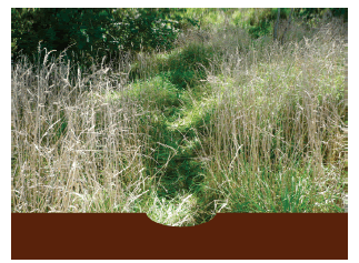
Figure 1. Preferential flow pathways in riparian vegetation strips.
Figura 1. Vía de flujo preferencial en franja de vegetación ribereña.
When considering PFP as open channels, its capacity to conduct the surface water flow can be quantified by the hydraulic radius (Rh) (Wobus et al. 2006), and their impact could be related to the hydraulic connection between the CF (source of pollutants) and the water courses where it discharges (Kouwen and Li 1980). Pollutant retention within the PFP may be also related to the surface roughness, which reduces the speed of runoff flow (Leeds- Harrison et al. 1999), the volume of surface runoff and, consequently, the detachment and transport of soil sediments (Cogo et al. 1983; Amoah et al. 2013). In this sense, Burwell and Larson (1969) demonstrated a highly positive correlation between soil infiltration capacity and rugosity. Neglecting this retention heterogeneity in RVS leads to wrong assessments and then to inappropriate environmental policies and/or wrong management decisions.
Therefore, the objective of the current article is to provide evidence of the magnitude and relevance of the heterogeneity of retention capacity of RVS. We hypothesize that: a) the retention of glyphosate, and its metabolite AMPA, phosphorus and nitrogen is not spatially uniform in RVS, and that can be detected areas of PFP where the retention is greater than in other areas, and b) there are hydraulic connections between adjacent CF and PFP where edaphic and hydraulic properties of PFP affecting those connections varying between PFP with or without trees.
MATERIALS AND METHODS
Study area and sampling design
The Pampas ecoregion is the most important grassland ecosystem of Argentina, comprising a surface of approximately 540000 km2. It has a relatively flat terrain with a gentle slope towards the Atlantic Ocean and soils suitable for crop production and cow-calf operation. The Austral Pampas is the most southern portion of this ecoregion and most of its area is devoted to annual crops (Soriano et al. 1991). The fluvial system is well defined and the area shows an exoreic basin with slow course meandering streams, low gradient riverbeds, silty or clay bottom and abundant organic detritus (Ringuelet 1962).
On this region, four sampling sites were selected in Azul, Tandil and Balcarce departments in order to cover a wide geographic area, taking into account their accessibility, similar slopes and soil textures, and presence of the most common vegetation, i.e., grassy vegetation dominated by the tall fescue, Festuca arundinacea Schreb., with or without a arboreal strata composed by willow, Salix fragilis L. (Giaccio et al. 2017). Geographical coordinates of the sampling sites are shown in Table 1 and their geographical locations are shown in Figure 2.
Table 1. Location of selected sampling sites.
Tabla 1. Ubicación de los sitios de muestreo seleccionados.


Figure 2. Location of the sampling sites (black dots) on Southern Pampa (Argentina): (A) Del Azul, (B) La Pastora, (C) San Felipe and (D) Napaleofú streams.
Figura 2. Ubicación de los sitios de muestreo (puntos negros) en la Pampa Austral de la Argentina: en arroyos (A) Del Azul, (B) La Pastora, (C) San Felipe y (D) Napaleofú.
In the four selected sites, sampling sites were located in "Del Azul", "La Pastora", "San Felipe" and "Napaleofú" streams on May 18, 2012 and August 24, 2012, there were significant floods caused by heavy rains (120 to 180 mm in 24 h) (Cazenave 2012). These periodic phenomena of short duration generated overflow of streams and water contributions by superficial flows which were utilized for detecting and selecting the most representative PFP (Figure 3).
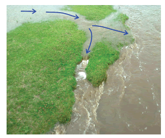
Figure 3. Preferential flow pathways.
Figura 3. Vía de flujo preferencial.
In each of the four sampling sites (Figure 4), five independent sampling areas were defined: CF, those outside of PFP with an arboreal stratum (PFPOT), outside of PFP without arboreal stratum (PFPO), inside of PFP with an arboreal stratum (PFPIT), and inside of PFP without arboreal stratum (PFPI). The relative area of PFP within the RVS was less than 10%, both in presence or absence of trees.

Figure 4. Riparian vegetation strips with and without trees and their preferential flow pathways in Del Azul (A), La Pastora (B), San Felipe (C) and Napaleofú (D) streams. Images of the GeoEye-1 satellite of 7/3/2013 provided by Google Earth Plus.
Figura 4. Franjas de vegetación ribereña con y sin árboles y sus vías de flujos preferenciales en arroyos Del Azul (A), La Pastora (B), San Felipe (C) y Napaleofú (D). Imágenes del satélite GeoEye-1 del 03/07/2013 provistas por Google Earth Plus.
Soil sampling
Composite soil samples were taken within each sampling plot between November 23rd and 26th, 2015. Each composite sample consisted of 20 cylindrical sub-samples of 2.5 cm diameter and 10 cm long for the analysis of nutrients and glyphosate concentration, and three additional subsamples of 5 cm diameter and 5 cm long for bulk density. The final sampling design was as follows: at least ten sampling positions were established on cropfield (CF) and RVS, each one separated by a distance of 10 m along sampling lines. Samples collected on inside of the PFP were called PFPI, while those obtained on the RVS but outside of PFP were named PFPo (Figure 5).

Figure 5. Spatial distribution of soil samples (X) in cropfield (orange area) and riparian vegetation strips (green area): inside and outside of preferential flow paths (PFPI and PFPO, respectively). Adapted from Sheppard et al. (2006).
Figura 5. Distribución espacial de muestras de suelo (X) en campos de cultivo (área naranja) y franjas de vegetación ribereña (área verde): dentro y fuera de las vias de flujo preferencial (PFPI y PFPO, respectivamente). Adaptado de Sheppard et al. (2006).
Soil glyphosate analysis
Glyphosate and AMPA concentrations were determined by liquid chromatography coupled to a tandem mass spectrometer (LC MS/MS), the limit of detection (LD) was 5 μg/ kg for AMPA and glyphosate, and the limit of quantification (LQ) was 10 μg/kg (Aparicio et al. 2013). Soil samples were thoroughly homogenized and refrigerated at 4 °C until their analysis.
Soil chemical analysis
Soil samples were taken for chemical analysis: available phosphorus (Pav) by Bray and Kurtz method Nº 1 (1945); total phosphorus (Pt) (Sommers and Nelson 1972); nitrate (NO3-) using the colorimetric technique of phenol disulfonic acid (Bremner and Keeney 1965); total nitrogen (Nt) by Kjeldahl semimicro method (Bremner and Mulvaney 1982) and pH was measured with a pH meter (Orion Expandable Ion Analyzer EA 940).
Physical and micro-topographic characterization
Bulk density was measured by the cylinder method (Blake and Hartge 1986) and soil texture was determined by the pipette method according to Robinson (Soil Conservation Service 1972). Surface microtopography was characterized by two morphometric descriptors: Rh and roughness. The Rh determinations were carried out to characterize the profile of the PFP in relation to the soil surface with or without trees. On the other hand, chain roughness (Cr) determinations were made in the RVS and PFP, both with and without trees.
A vertical needle frame was used to determine Rh (Allmaras et al. 1966). The choice of this method was based on its simplicity, reliability and low cost (García Moreno et al. 2008b; Moreno et al. 2008). Six measurements were made within each PFP, locating the frame parallel to the stream channel and along a transect perpendicular to it. Within each transect, the frame was located at variable distances trying to maximize the microtopographic variability of the site (the use of fixed distances can cause loss of information). Considering a triangle with rounded bottom as an approximation to sections of natural channels of small and medium size, the Rh coefficient is calculated following Chow (1994) (Equation 1), as
Rh = A / P Equation 1
where A is the wetted area, defined as the cross-sectional area of the flow, perpendicular to the flow direction, expressed in square meters, and P is the wetted perimeter, defined as the surface of the channel bottom and sides in direct contact with the aqueous body, expressed in meters.
Roughness was estimated using the chain method or chain roughness (Thomsen et al. 2015) was used to calculate the Cr index, as a measure of the roughness (Saleh 1993). A chain of 1.29 m of length was randomly placed within the sampling areas. Length measurements between the chain extremes were registered at four times by plot. Since we were interested in the roughness due to soil microtopography plus vegetation we did not remove the vegetation cover and the chain was carefully placed over it. The ratio between the chain lengths (L1) over the Euclidean distance between its extremes (L2) was used to calculate the Cr index, using Equation 2 (Saleh 1993).
Cr = 100 * (1 - L2 / L1) Equation 2
Statistical analysis
The results were expressed as the averages of four replicates (streams) and tested for normality, variance homogeneity, independence and block-treatment additivity. To test for the first hypothesis, the physicalchemical variables of the studied soils were analyzed by means of a one-way analysis of variance (ANOVA) following a randomized complete block design with four replicates. Two factors were considered as classification variables: 1) presence or absence of arboreal stratum, and 2) microtopographic position (inside or outside of PFP). The second hypothesis was tested using one-way analysis of variance (ANOVA) for a block design (streams) and five treatments: CF, PFPOT, PFPO, PFPIT and PFPI. Variables showing significant differences at a 5% probability level were subjected to multiple comparison analysis using the Tukey test. Statistical analyses were performed using the R-Commander package (Fox 2005) software (R Core Team 2016).
RESULTS AND DISCUSSION
Retention in preferential flow pathways
Glyphosate and AMPA concentration was 88 times higher in the PFP with or without trees (PFPI and PFPIT) than outside (PFPOT and PFPO). A significant interaction between presence or absence of an arboreal stratum and microtopographic position was detected, where glyphosate and AMPA concentration was higher in the PFP without trees (PFPI) than in the PFP with trees (PFPIT) (Figure 6). Glyphosate concentrations within PFP were similar to those found in uniform RVS plots by Syversen (2003) and Syversen and Bechmann (2004).

Figure 6. Glyphosate and AMPA concentration in soil samples from outside PFP with and without an arboreal stratum (PFPOT and PFPO, respectively) and inside PFP with and without an arboreal stratum (PFPIT and PFPI, respectively). Vertical bars represent standard deviation of the mean and different letters indicate significant differences among means (P≤0.05).
Figura 6. Concentración de glifosato y AMPA en muestras de suelo fuera de las PFP con y sin un estrato arbóreo (PFPOT y PFPO, respectivamente) y dentro de las PFP con y sin estrato arbóreo (PFPIT y PFPI, respectivamente). Las barras verticales representan la desviación estándar de la media y las letras diferentes indican diferencias significativas entre las medias (P≤0.05).
Available and total phosphorus and nitrate concentrations were higher in the PFP than outside, regardless of the presence or absence of trees (Figures 7A, 7B, 7C). While the differences in total nitrogen were not significant among treatments (PFPOT: 341; PFPO: 335.75; PFPIT: 454; PFPI: 355.75, respectively). The high nutrient content inside of the PFP not only reflects a high runoff flow, but also a great nutrient retention which agrees with similar studies (e.g., Suescún et al. 2017). Alternatively, riparian soils act as a sink or source of phosphorus to the overlaying water due to phosphorus sorptiondesorption processes (Bai et al. 2017). These results suggest that even in regions of very low slope, hydraulic connectivity between CF and surface water bodies is favoured by PFP (Taboada et al. 2009), where part of sediments, phosphorus and pesticides carried by runoff are retained (Sheppard et al. 2006; Zaimes et al. 2008).

Figure 7. Available phosphorus (A), total phosphorus (B) and nitrate (C) concentrations in sample soils from outside PFP with and without an arboreal stratum (PFPOT and PFPO, respectively) and inside PFP with and without an arboreal stratum (PFPIT and PFPI, respectively). Vertical bars represent standard deviation of the mean and different letters indicate significant differences among means (P≤0.05).
Figura 7. Concentración de fósforo disponible (A), fósforo total (B) y nitratos (C) en muestras de suelos fuera de las PFP con y sin un estrato arbóreo (PFPOT y PFPO, respectivamente) y dentro de las PFP con y sin un estrato arbóreo (PFPIT y PFPI, respectivamente). Las barras verticales representan la desviación estándar de la media y las letras diferentes indican diferencias significativas entre las medias (P≤0.05).
Due to its high solubility in water, nitrate is easily transported by leaching to groundwater (Haag and Kaupenjohann 2001). However, the high concentration of nitrate recorded inside of the PFP suggests that when surface runoff occurs, nitrate is not only horizontally transported through the PFP, but also adsorbed within them (Oenema and Roest 1998; Hatch et al. 2002; Roberts et al. 2012). Another possibility could be that the soil of the RVS is saturated due to a close to the surface water table. In this case the measured nitrate would correspond to the soil solution. Therefore, glyphosate, phosphorus and nitrate content in the PFP depend on a dynamic balance among the input, retention efficiency and removal rates. The low topographic position of RVS in the landscapes, and the presence of the water table at shallow depth can remove or import part of these retained nitrate through mass flow (Haag and Kaupenjohann 2001; Kuglerová et al. 2014). The magnitude of these losses depends on the amount of nitrate present in the soil and the volume of drained water (Vinten and Smith 1993).
The great retention within PFP is due to the fact that the glyphosate molecules, as well as those of phosphorus, present a high affinity to adsorb superficially to clay particles (Carriquiriborde 2010), which are detached from the adjacent soils by erosive effects, transported by runoff and deposited in the PFP (Welten 2000; Carriquiriborde 2010). In addition, clay is the sediment component that is most retained in riparian soils (Magette et al. 1989; Lyons et al. 2000; Ghadiri et al. 2001; Giaccio et al. 2016). Likewise, glyphosate has high solubility in water (Mayer et al. 2006) that favours its transport by runoff.
Inside vs. outside PFP conditions
Both the bulk density and clay content are higher in the CF and PFP than outside the PFP, regardless of the presence of a tree stratum (Figures 8A, 8B), suggesting a higher hydraulic connection of CF with PFP than CF with the rest of the RVS. The lower values of bulk density outside PFP than in the CF agree with similar studies which probably ignored the PFP assuming that RVSs are homogeneous (e.g., Stutter and Richards 2012). The relatively high values of bulk density in the PFP could be associated to trampling by livestock (Hairsine et al. 2001) and deposition of clay carried by runoff from CF within the macropores, which, in turn, would promote reductions in the infiltration rates (Jones 1987; Chappell and Ternan 1992), increasing the surface runoff within PFP (O'Connell et al. 2007; Magner et al. 2008).

Figure 8. Comparison of bulk density (A) and clay content (B) of soil samples of the crop-field (CF) adjacent and outside PFP with and without an arboreal stratum (PFPOT and PFPO, respectively) and inside PFP with and without an arboreal stratum (PFPIT and PFPI, respectively). Vertical bars represent standard deviation of the mean and different letters indicate significant differences among means (P≤0.05).
Figura 8. Comparación de la densidad aparente (A) y del contenido de arcilla (B), de las muestras de suelos de campos de cultivo (CF) adyacentes, fuera de las PFP con y sin un estrato arbóreo (PFPOT y PFPO, respectivamente) y dentro de las PFP con y sin un estrato arbóreo (PFPIT y PFPI, respectivamente). Las barras verticales representan la desviación estándar de la media y las letras diferentes indican diferencias significativas entre las medias (P≤0.05).
The presence of contrasting vegetation did not modify the Rh of the PFP (0.01 and 0.02 for PFP with and without trees, respectively). The soil surface roughness increases with grass cover and that was highest when there were no trees, both inside and outside the PFP (Dillaha et al. 1989; Orué 2008). Soil surface roughness was 1.2 times higher outside the PFP than inside it, and in turn, 1.5 times higher outside the PFP without trees than outside the PFP with trees, as revealed by the additive effects among PFP factors and presence or absence of trees (Figure 9). Our results highlight the need to evaluate previous conclusions based on uniform experimental plots in RVS with caution and the current work also shows the relevance of taking into account the genesis and structure of superficial PFP in the design, evaluation and management of RVS. Therefore, in agreement with other studies focused on non-uniform RVS, the presence of PFP proved to be much more important as a predictor of their retention capacity than the type of vegetation (Dillaha et al. 1989; Sheppard et al. 2006; Hösl et al. 2012).

Figure 9. Comparison of soil surface roughness measured on outside PFP with and without an arboreal stratum (PFPOT and PFPO, respectively) and inside PFP with and without an arboreal stratum (PFPIT and PFPI, respectively). Vertical bars represent standard deviation of the mean and different letters indicate significant differences among means (P≤0.05).
Figura 9. Comparación de la rugosidad de la superficie del suelo medida fuera de las PFP con y sin un estrato arbóreo (PFPOT y PFPO, respectivamente) y dentro de las PFP con y sin un estrato arbóreo (PFPIT y PFPI, respectivamente). Las barras verticales representan la desviación estándar de la media y las letras diferentes indican diferencias significativas entre las medias (P≤0.05).
In conclusion, glyphosate and AMPA, available and total phosphorus and nitrate in RVS were found more retained (as reflected by soil content) inside than outside of the PFP and presence and functionality of PFP was put in evidence. Therefore, due to higher values of bulk density and clays in the CF and inside PFP than outside of the PFP, as well as by the higher retention values inside than outside them, an active hydraulic connection exists between the PFP and the CF. In presence of PFP, vegetation characteristic shows only a minor relevance to retention capacity. In contrast to previous results (Kouwen and Li 1980), micro-topographic and texture differences due to presence or absence of trees seemed to be not enough to modify the retention levels in most of the cases. This could be explained by a relatively low accumulation of litter in the undergrowth of Salix sp., which does not influence the ability to flow and reduce the speed of runoff flows.
ACKNOWLEDGEMENTS
This work is part of the doctoral studies of Gustavo Carlos María Giaccio at the Facultad de Ciencias Agrarias, Universidad Nacional de Mar del Plata (Argentina). Nutrients and glyphosate content in soil samples were performed by the Chemical Analysis Laboratory of the Universidad Nacional del Sur, and the INTA Balcarce Agricultural Experimental Station. This research was funded by the projects BEST-p (Bridging Ecosystem Services and Territorial Planning); Inter-American Institute for Global Change Research (IAI) CRN3095 which is supported by the US National Science Foundation (Grant GEO-1128040), MINCYTArgentina (PICT 2012-0607 and PICT 2015 0672), VESPLAN (CYTED Red413RT0472) and Instituto Nacional de Tecnología Agropecuaria.
REFERENCES
1. Allmaras, R. R., R. E. Burwell, W. E. Larson, R. Holt, and W. W. Nelson. 1966. Total porosity and random roughness of the inter row zone as influenced by tillage. United States Department of Agriculture. Washington, D.C. Conservation Research Report N° 7. Pp. 22. [ Links ]
2. Amoah, J. K. O., D. M. Amatya, and S. Nnaji. 2013. Quantifying watershed surface depression storage: determination and application in a hydrologic model. Hydrological Processes 27:2401-2413. https://doi.org/10.1002/hyp.9364. [ Links ]
3. Aparicio, V., E. De Gerónimo, K. Hernández Guijarro, D. Pérez, R. Portocarrero, and C. Vidal. 2015. Los plaguicidas agregados al suelo y su destino en el ambiente. 1a ed. Balcarce, Buenos Aires; Famaillá, Tucumán; Reconquista, Santa Fe. Ediciones INTA. Pp. 73. [ Links ]
4. Aparicio, V. C., E. De Gerónimo, D. Marino, J. Primost, P. Carriquiriborde, and J. L. Costa. 2013. Environmental fate of glyphosate and aminomethylphosphonic acid in surface waters and soil of agricultural basins. Chemosphere 93(9): 1866-1873. https://doi.org/10.1016/j.chemosphere.2013.06.041. [ Links ]
5. Bai, J., X. Ye, J. Jia, G. Zhang, Q. Zhao, B. Cui, and X. Liu. 2017. Phosphorus sorption-desorption and effects of temperature, pH and salinity on phosphorus sorption in marsh soils from coastal wetlands with different flooding conditions. Chemosphere. https://doi.org/10.1016/j.chemosphere.2017.08.117. [ Links ]
6. Blake, G. R., and K. H. Hartge. 1986. Bulk density. Pp. 363-382 in A. Klute (ed.). Methods of Soil Analysis. Part 1. 2nd ed. Agronomy Monograph 9, American Society of Agronomy - Soil Science Society of America, Madison. USA. [ Links ]
7. Bray, R. H., and L. T. Kurtz. 1945. Determination of total, organic and available forms of phosphate in soils. Soil Science 59(1):39-45. https://doi.org/10.1097/00010694-194501000-00006. [ Links ]
8. Bremner, J. M., and D. R. Keeney. 1965. Steam distillation methods for determination of ammonium, nitrate and nitrite. Analytica Chimica Acta 32:485-495. https://doi.org/10.1016/S0003-2670(00)88973-4. [ Links ]
9. Bremner, J. M., and C. S. Mulvaney. 1982. Total Nitrogen. Pp. 595-624 in A. Klute (ed.). Methods of Soil Analysis. Part 2. Agronomy Monograph 9, American Society of Agronomy - Soil Science Society of America, Madison. USA.
10. Burwell, R. E., and W. E. Larson. 1969. Infiltration as influenced by tillage induced roughness and pore space. Soil Science Society of America, Proceedings 33(3):449-452. https://doi.org/10.2136/sssaj1969.03615995003300030032x. [ Links ]
11. Carriquiriborde, P. 2010. Toxicidad de glifosato en peces autóctonos: estudios de laboratorio y campo. Pp. 114 en M. Camino and V. Aparicio (eds.). Aspectos ambientales del uso de glifosato. Ediciones INTA. EEA Balcarce. [ Links ]
12. Cazenave, G. 2012. Inundaciones del 18 y 24 de agosto de 2012. Informe de actividades. Instituto de Hidrología de Llanuras. Universidad Nacional del Centro de la Provincia de Buenos Aires. Pp. 11. [ Links ]
13. Chappell, N., and L. Ternan. 1992. Flow path dimensionality and hydrological modelling. Hydrological Processes 6: 327-345. https://doi.org/10.1002/hyp.3360060307. [ Links ]
14. Chow, V. T. 1994. Hidráulica de canales abiertos. Ed. McGraw-Hill. ISBN: 958-600-228-4. Pp. 19-23. [ Links ]
15. Cogo, N. P., W. C. Moldenhauer, and G. R. Foster. 1983. Effect of crop residue, tillage-induced roughness and runoff velocity on size distribution of eroded soil aggregates. Soil Science Society of America Journal 47:1005-1008. https://doi.org/10.2136/sssaj1983.03615995004700050033x. [ Links ]
16. Dillaha, T. A., R. B. Reneau, S. Mostaghimi, and D. Lee. 1989. Vegetative filter strips for agricultural nonpoint source pollution control. Transactions of the American Society of Agricultural Engineers 32:513-519. https://doi.org/10.13031/2013.31033. [ Links ]
17. Fox, J. 2005. The R Commander: A basic-statistics graphical user interface to R. J Stat Softw 19(9):1-42. https://doi.org/10.18637/jss.v014.i09. [ Links ]
18. García Moreno, R., A. Saa Requejo, A. M. Tarquis Alonso, S. Barringron, and M. C. Díaz. 2008b. Shadow analysis: a method for measuring soil surface roughness. Geoderma 146:201-208. https://doi.org/10.1016/j.geoderma.2008.05.026. [ Links ]
19. Ghadiri, H., C. W. Rose, and W. L. Hogarth. 2001. The influence of grass and porous barrier strips on runoff hydrology and sediment transport. Transactions of the American Society of Agricultural Engineers 44:259-268. https://doi.org/10.13031/2013.4687. [ Links ]
20. Giaccio, G. C. M. 2017. Retención de sedimentos, nutrientes y glifosato por ecosistemas ribereños en paisajes agrícolas de la Pampa Austral. Tesis de Doctorado en Ciencias Agrarias. Universidad Nacional de Mar del Plata. Argentina. Pp. 208. [ Links ]
21. Giaccio, G. C. M., P. Laterra, and F. Cabria. 2017. Floristic associations and filtering ability of riparian vegetation strips. Phyton, International Journal of Experimental Botany 86:112-123. [ Links ]
22. Giaccio, G. C. M., P. Laterra, V. C. Aparicio, and J. L. Costa. 2016. Glyphosate retention in grassland riparian areas is reduced by the invasion of exotic trees. Phyton, International Journal of Experimental Botany 85:108-116. [ Links ]
23. Haag, D., and M. Kaupenjohann. 2001. Landscape fate of nitrate fluxes and emissions in Central Europe. A critical review of concepts, data, and models for transport and retention. Ecosystems and Environment 86:1-21. https://doi.org/10.1016/S0167-8809(00)00266-8. [ Links ]
24. Hatch, D., K. Goulding, and D. Murphy. 2002. Nitrogen. Pp. 502 in P. M. Haygarth and S. C. Jarvis (ed.). Agriculture, Hydrology and Water Quality. Institute of Grassland and Environmental Research, North Wyke Research Station, Devon, UK. [ Links ]
25. Hoffmann, C. C., C. Kjaergaard, J. Uusi-Kämppä, H. C. B. Hansen, and B. Kronvang. 2009. Phosphorus retention in riparian buffers: Review of their efficiency. Journal of Environmental Quality 38:1942-1955. https://doi.org/10.2134/jeq2008.0087. [ Links ]
26. Hösl, R., P. Strauss, and T. L. Glade. 2012. Man-made linear flow paths at catchment scale: Identification, factors and consequences for the efficiency of vegetated filter strips. Landscape and Urban Planning 104:245-252. https://doi.org/10.1016/j.landurbplan.2011.10.017. [ Links ]
27. Jones, J. A. A. 1987. The effect of soil piping on contributing areas and erosion patterns. Earth Surface Processes and Landforms 12:229-248. https://doi.org/10.1002/esp.3290120303. [ Links ]
28. Kouwen, N., and R. M. Li. 1980. Biomechanics of vegetative channel linings. Journal of Hydraulics Division 106:1085- 1103. https://doi.org/10.1007/978-3-642-67138-8_2. [ Links ]
29. Kronvang B., J. Audet, A. Baattrup-Pedersen, H. S. Jensen, and S. E. Larsen. 2012. Phosphorus load to surface water from bank erosion in a Danish lowland river basin. Journal of Environmental Quality 41:304-313. https://doi.org/10.2134/jeq2010.0434. [ Links ]
30. Kuglerová, L., R. Jansson, Å. Annelli, L. Hjalmar, and B. Malm-Renõfält. 2014. Groundwater discharge creates hotspots of riparian plant species richness in a boreal forest stream network. Ecology 95(3):715-725. https://doi.org/10.1890/13-0363.1. [ Links ]
31. Leeds-Harrison, P. B., J. N. Quinton, M. J. Walker, C. L. Sanders, and T. Harrod. 1999. Grassed buffer strips for the control of nitrate leaching to surface waters in headwater catchments. Ecological Engineering 12:299-313. https://doi.org/10.1016/S0925-8574(98)00075-5. [ Links ]
32. Lyons, J., S. W. Trimble, and L. K. Paine. 2000. Grass versus trees: managing riparian areas to benefit streams of central North America. Journal of the American Water Resources Association 36(4):919-930. https://doi.org/10.1111/j.1752-1688.2000.tb04317.x. [ Links ]
33. Magette, W. L., R. B. Brinsfield, R. E. Palmer, and J. D. Wood. 1989. Nutrient and sediment removal by vegetated filter strips. American Society of Agricultural and Biological Engineers 32(2):0663-0667. https://doi.org/10.13031/2013.31054. [ Links ]
34. Magner, J. A., B. Vondracek, and K. N. Brooks. 2008. Grazed riparian management and stream channel response in Southeastern Minnesota (USA) streams. Environmental Management 42:377-390. https://doi.org/10.1007/s00267-008-9132-4. [ Links ]
35. Mayer, P. M., S. K. Reynolds, M. D. McCutchen, and T. J. Canfield. 2007. Meta-analysis of nitrogen removal in riparian buffers. Journal of Environmental Quality 36:1172-1180. [ Links ]
36. Mayer, P. M., S. K. Reynolds, M. D. McCutchen, and T. J. Canfield. 2006. Riparian Buffer Width, Vegetative Cover, and Nitrogen Removal Effectiveness: A Review of Current Science and Regulations. EPA/600/R-05/118. U.S. Environmental Protection Agency, Cincinnati, OH. https://doi.org/10.2134/jeq2006.0462. [ Links ]
37. Moreno, R., M. C. Díaz Álvarez, A. M. Tarquis Alonso, S. Barrington, and A. Saa Requejo. 2008. Tillage and soil type effects on soil surface roughness at semiarid climatic conditions. Soil and Tillage Research 98:35-44. https://doi.org/10.1016/j.still.2007.10.006. [ Links ]
38. O’Connell, E., J. Ewen, G. O’Donnell, and P. Quinn. 2007. Is there a link between agricultural land-use management and flooding? Hydrology and Earth System Science 11:96-107. https://doi.org/10.5194/hess-11-96-2007.
39. Oenema, O., and C. W. J. Roest. 1998. Nitrogen and phosphorus losses from agriculture into surface waters: the effects of polices and measures in the Netherlands. Water Science and Technology 37(2):19-30. https://doi.org/10.2166/wst.1998.0167. [ Links ]
40. Okada, E., J. L. Costa, and F. Bedmar. 2017. Glyphosate Dissipation in Different Soils under No-Till and Conventional Tillage. Pedosphere. https://doi.org/10.1016/S1002-0160(17)60430-2. [ Links ]
41. Orué, E. 2008. Manejo de ambientes ribereños. Guía práctica para el diseño óptimo de franjas filtro vegetadas. Not published. [ Links ]
42. Orué, E., P. Laterra, and F. Cabria. 2007. Expansión de la frontera agrícola en Argentina y erosión hídrica: mapas de riesgo utilizando el modelo USLE con apoyo de SIG. Pp. 185-192 en R. Rivas, A. Grisotto and M. Sacido (eds.). Teledetección. Hacia un Mejor Entendimiento de la Dinámica Global. [ Links ]
43. R Development Core Team. 2009. R: A language and environment for statistical computing. R Foundation for Statistical Computing. Viena, Austria. [ Links ]
44. Ranalli, A. J., and D. L. Macallady. 2010. The importance of the riparian zone and in-stream processes in nitrate attenuation in undisturbed and agricultural watersheds - A review of the scientific literature. Journal of Hydrology 389:406-415. https://doi.org/10.1016/j.jhydrol.2010.05.045. [ Links ]
45. Ringuelet, R. A. 1962. Ecología Acuática Continental. EUDEBA. Buenos Aires. Pp. 137. [ Links ]
46. Roberts, W., M. I. Stutter, and P. M. Haygarth. 2012. Phosphorus retention and remobilization in vegetated buffer strips. Journal of Environmental Quality 41:389-399. https://doi.org/10.2134/jeq2010.0543. [ Links ]
47. Saleh, A. 1993. Soil roughness measurement? Chain method. Journal of Soil and Water Conservation 48:527-529. [ Links ]
48. Sasal, M. C., A. E. Andriulo, M. G. Wilson, and S. I. Portela. 2010. Pérdidas de glifosato por drenaje y escurrimiento en Molisoles bajo siembra directa. Información Tecnológica 2:135-142. https://doi.org/10.4067/S0718-07642010000500017. [ Links ]
49. Sheppard, S. C., M. I. Sheppard, J. Lonj, B. Sanipelli, and J. Tait. 2006. Runoff phosphorus retention in vegetated field margins on flat landscapes. Canadian Journal of Soil Science 86:871-884. https://doi.org/10.4141/S05-072. [ Links ]
50. Sommers, L. E., and W. Nelson. 1972. Determination of total phosphorus in soils: a rapid perchloric and digestion procedure. Soil Science Society of America Proceedings 36:902-903. https://doi.org/10.2136/sssaj1972.03615995003600060020x. [ Links ]
51. Soil Conservation Service. 1972. Soil Survey Laboratory Methods and Procedures for Collecting Soils Samples. Soil Survey. Report 1. USDA, WA. [ Links ]
52. Soriano, A., R. J. C. León, O. E. Sala, R. S. Lavado, V. A. Deregibus, M. A. Cahuepé, O. A. Scaglia, C. A. Velázquez, and J. H. Lemcoff. 1991. Río de la Plata Grasslands. Pp. 367-407 in R. T. Coupland (ed.). Natural grasslands. Introduction and western hemisphere. Ecosystems of the World. Elsevier, New York. [ Links ]
53. Suescún, D., J. C. Villegas, J. D. León, C. P. Flórez, V. García-Leoz, and G. A. Correa-Londoño. 2017. Vegetation cover and rainfall seasonality impact nutrient loss via runoff and erosion in the Colombian Andes. Regional Environmental Change 17:827-839. https://doi.org/10.1007/s10113-016-1071-7. [ Links ]
54. Syversen, N. 2003. Cold-climate vegetative buffer zones as pesticide-filters for surface runoff. Diffuse Pollution Conference Dublin. Pp. 7. [ Links ]
55. Syversen, N., and M. Bechmann. 2004. Vegetative buffer zones as pesticide filters for simulated surface runoff. Ecological Engineering 22:175-184. https://doi.org/10.1016/j.ecoleng.2004.05.002. [ Links ]
56. Taboada, M. A., F. Damiano, and R. S. Lavado. 2009. Inundaciones en la Región Pampeana. Consecuencias sobre los Suelos. Pp. 103-127 en M. A. Taboada y R. S. Lavado (eds.). Alteraciones de la fertilidad de los suelos: el halomorfismo, la acidez, el hidromorfismo y las inundaciones. EFA, Buenos Aires. ISBN 978-950-29-1162-5. [ Links ]
57. Thomsen, L. M., J. E. M. Baartman, R. J. Barneveld, T. Starkloff, and J. Stolte. 2015. Soil surface roughness: comparing old and new measuring methods and application in a soil erosion model. Soil 1:399-410. https://doi.org/10.5194/soil-1-399-2015. [ Links ]
58. Vinten, A., and K. Smith. 1993. Nitrogen Cycling in agricultural soil. Pp. 39-74 in T. P. Burt, A. L. Heathwaite and S. T. Trudgill (eds.). Nitrate: Processes, Patterns and Management, Wiley, New York. [ Links ]
59. Welten, R. 2000. Ecotoxicity of contaminated suspended solids for filter feeders (Daphnia magna). Environmental Contamination and Toxicology 39(3):315-323. https://doi.org/10.1007/s002440010110. [ Links ]
60. Wobus, C. W., G. E. Tucker, and R. S. Anderson. 2006. Self-formed bedrock channels. Geophysical Research Letters 33: L18408. https://doi.org/10.1029/2006GL027182. [ Links ]
61. Zaimes, G. N., R. C. Schultz, and T. M. Isenhart. 2008. Total phosphorus concentrations and compaction in riparian areas under different riparian land-uses of Iowa. Agriculture, Ecosystems and Environment 127:22-30. https://doi.org/10.1016/j.agee.2008.02.008. [ Links ]

