


Servicios Personalizados
Revista

Articulo
 Inglés (pdf)
 Articulo en XML
 Referencias del artículo
 Enviar articulo por email
Indicadores
-
 Citado por SciELO
Links relacionados
-
 Similares en
SciELO
Similares en
SciELO
Compartir

 Permalink
Ciencia del suelo
versión On-line ISSN 1850-2067
Cienc. suelo vol.26 no.2 Ciudad Autónoma de Buenos Aires ago./dic. 2008
TRABAJOS
Regional scale modeling of erosion related to land cover evolution: a case study in brazilian southeastern region
Alexandre Marco Da Silva 1
1 Departamento de Engenharia Ambiental - UNESP - Campus Sorocaba. Avenida Três de Março, 511. Bairro Altos da Boa Vista - Sorocaba - SP, Brasil. Zip code 18.087-180. E-mail: amsilva@sorocaba.unesp.br
Recibido: 14/08/07
Aceptado: 22/08/08
ABSTRACT
Accelerated soil erosion is, at present, one of the most widespread environmental problems in the world. Geographic Information Systems (GIS) have become an essential tool in soil erosion studies and consequently in the development of appropriate soil conservation strategies. The objective of this paper was to assess the degree of soil erosion associated with land cover dynamics through GIS analysis and to validate the modeling with indicators of soil erosion. Universal Soil Loss Equation (USLE) model, GIS technology and ground-truth dataset (erosion indicators) were employed to elaborate the soil loss maps for four dates at Sorocaba Municipality (SP, Brazil). It was verified that, although the predicted soil loss rate is normally small along the study area, such rate is significantly greater than the soil formation rate. This shows a non-sustainable situation of soil and land cover management. Unplanned urban expansion seems be the main driving force that acts in increasing the erosion risk/occurrence along the study area.
Key words. Environmental change; Water erosion; USLE; GIS.
Modelagem em escala regional da erosão relacionada com a evolução da cobertura do solo: um estudo de caso no sudeste do Brasil
RESUMO
A erosão acelerada é um dos maiores problemas ambientais ocorrentes em larga escala na atualidade. Por sua vez, Sistemas de Informação Geográfica (SIG) tornou-se uma ferramenta essencial em estudos de erosão e conseqüentemente no desenvolvimento de estratégias apropriadas para a conservação do solo. O objetivo deste trabalho foi avaliar o grau de erosão do solo associada com a dinâmica da cobertura do solo através de uma análise geoespacial e validar a modelagem com indicadores de erosão. Utilizou-se a Equação Universal de Perda de Solo (EUPS), recursos de SIG e dados de campo (indicadores de erosão) para elaborar os mapas de perda de solo para quatro datas para o município de Sorocaba (SP, Brasil). Verificou-se que, embora a taxa de perda de solo ao longo da área de estudo é normalmente baixa, esta taxa é expressivamente maior que as taxas de formação do solo. Isto mostra uma situação não sustentável de uso da terra. Expansão urbana não planejada parece ser o principal agente que proporciona o crescimento da ocorrência/risco de erosão ao longo da área de estudo.
Palavras chave. Alteração ambiental; Erosão hídrica; EUPS; SIG.
INTRODUCTION
Soil erosion is a geomorphic process that occurs under many circumstances worldwide. It can be caused by wind, snowmelt and/or raindrop/runoff actions. It is a natural phenomenon that is responsible for the modeling of the Earth's topography through soil loss, sediment transport and deposition. Conversely, the anthropogenic erosion is an accelerated form of the natural erosion process and the soil loss rates are much higher than the natural rates (Kirkby, 2001).
Land-use and land-cover change are the result of many interacting processes (Verburg et al., 2002). Land cover change through time is closely driven by human population increase and distribution (L.R.R.B., 2003), rendering the soil more susceptible to erosion.
The erosion process can be observed and quantified under various methods (Boix-Fayos et al., 2006). One of the most common is the mathematical approach, where many mathematical models have been developed. In general, the aim is to understand and predict the soil loss according to environmental conditions, some of them integrated with GIS technology (Mati et al., 2000).
In order to complement the GIS work and validate the results obtained from the modeling, ground-truth data is commonly used, both quantitative and/or qualitative.
Quantitative data is usually obtained from experimental plots (Jimoh, 2001). On the other hand, qualitative data are obtained from erosion indicators (Okoba & Sterk, 2006) and can also be used to complement the GIS work and modeling.
In Brazil, the erosion processes occur in different forms and intensities due to the big territorial dimensions of the country. Rainfall is the main factor that initiates the soil erosion process (Silva, 2004). Conversely, the anthropogenic influence varies along the country and results in different forms of soil and land cover management.
The State of São Paulo is the most developed Brazilian State and encompasses a great part of the Brazilian population and of the Gross National Product. In addition, Sorocaba is an important Brazilian municipality (Seade, 2006). Due to the high importance that the erosion process exerts, at equilibrium, of the ecological dynamics of a region, for Sorocaba Municipality it is considered a poorly investigated phenomenon both in urbanized and in rural areas.
Hence, the objective of this paper was to investigate the rate of soil loss that is associated with land use dynamics in Sorocaba Municipality and to validate the modeling with indicators of erosion.
PROCEDURES
Study Area
Our case study is Sorocaba, located in the Southeastern Brazilian region (São Paulo State) (Figure 1). It has an area of 456 km2 and approximately 532,000 inhabitants, 98% of them living in urban settlements. It is an important socio-economic center, encompassing 1,078 industries (Seade, 2006) and showing an advanced urban expansion (Figure 1).
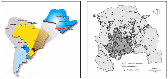
Figure 1. Localization of the study area (not scaled, left) and land use map for Sorocaba Municipality (2003).
Figura 1. Localização da área de estudo (sem escala, esquerda) e mapa de uso da terra para o município de Sorocaba (2003).
The annual average temperature is 21.4 oC and the annual average rainfall is 1,285 mm. The elevation ranges from 500 to 1,033 m above sea-level. Topography is highly variable: in the western area, where the land is intensively used for agriculture, the relief is flat or smoothly rolling. In the eastern area, topography is rolling to hilly. In the latter area the natural remnant vegetation occurs more frequently. There are two main soil classes: Yellow-red Alfisols and Red Oxisols, both dystrophic (Oliveira et al., 1999).
Land cover maps
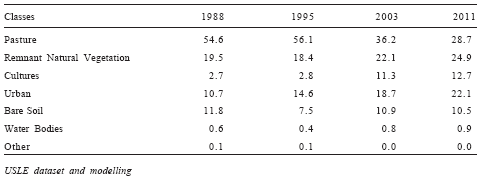
Four land cover maps of the study area were compiled by Silva (submitted) using three Landsat satellite images (1988, 1995 and 2003). The fourth land cover map was of 2011 and was compiled through Markov chain model (Aaviksoo, 1995; Eastman, 2004). The land cover classes and the percentage of occurrence of each land cover class according to the year are presented in Table 1. These land cover maps were used for determination of the C and P factors layers of the Universal Soil Loss Equation.
Table 1. Percentage of occurrence of each land cover class for each analyzed year.
Tabela 1. Porcentagem de ocorrência da cada classe de cobertura do solo para cada ano analisado.
The Universal Soil Loss Equation (USLE) was the mathematical model used for predicting soil loss along the study site (Wischmeier & Smith, 1978). The USLE is:
Where: A - rate of soil loss (Mg ha-1 y-1), R - annual rainfall erosivity (MegaJoule mm ha-1 hr-1 y-1), K - soil erodibility (Mg hr MegaJoule-1 mm-1), L - slope length, S - slope steepness, C - cover management, and P - supporting practices. The last four factors are dimensionless.
All six parameters of the USLE were separately investigated and subsequently integrated through GIS techniques (Idrisi - Kilimanjaro version (Eastman, 2004)):
R factor layer - this layer was elaborated using the database and digital map of the rainfall erosivity for the Brazilian territory, extracted from the database elaborated and cited in Silva (2004).
K factor layer - it was generated by using the São Paulo state pedological map (Oliveira et al., 1999) and erodibility values according to soil unity. The detailed erodibility database for soil unities occurring along São Paulo State is presented in Silva & Álvares (2005). The classes Oxisol and Ultisol showed K values of 0.0162 and 0.0425 Mg h MJ-1 mm-1, respectively (Silva & Álvares, 2005).
The pedological map used in this study includes the class "urbanization". According to De Kimpe & Morel (2000), within urban and suburban areas, soils are the support for diversified anthropocentric activities and needs: as infrastructure at the soil surface and underground, source and sink of raw materials; food production; recreational activities (e.g., parks); and memory and cultural heritage (e.g., cemeteries). As it is currently impossible to check the soil classes occurring along the urban area of Sorocaba, the average value for erodibility for this soil category was adopted (0.0293 Mg h MJ-1 mm-1).
LS factor layer - a 30-m resolution Digital Elevation Model (DEM) of the study area was used. The LS factor layer was generated using the DEM and the USLE-2D software (Van Oost & Govers, 2005). The value of each cell of this layer corresponds to the LS factor.
C factor layer - digital land cover maps (1988, 1995, 2003 and 2011) were used for checking the land cover classes (the land cover classes were the same). A specific "C" value was attributed to each land cover class, (Mitchell & Bubenzer, 1980). The land cover classes Pasture and Urban received C values = 0.01. The value for Remnant Natural Vegetation was 0.001; 0.1 for Cultures; 1.0 for Bare Soil; 0 for Water Bodies and 0.005 for Other.
P factor layer - similarly as the C factor, the same four land cover maps were used to elaborate the "P" factor layer and a dataset was also extracted from Mitchell & Bubenzer (1980) and Cerri et al. (2001). The value "0.5" was given to Pasture and Cultural classes since contour farming is a common practice. For the remaining land cover classes support practices are not used. Hence, the P value was 1. Such information was obtained through many field surveys.
The same C and P values were assumed for each land cover class for all land cover maps (1988, 1995, 2003 and 2011).
Once the information for each USLE factor was determined, the respective layers were gathered in order to generate the Soil Loss Expectative map (SLE). The SLE map was reclassified into five interpretation classes.
Validation of the USLE modelling
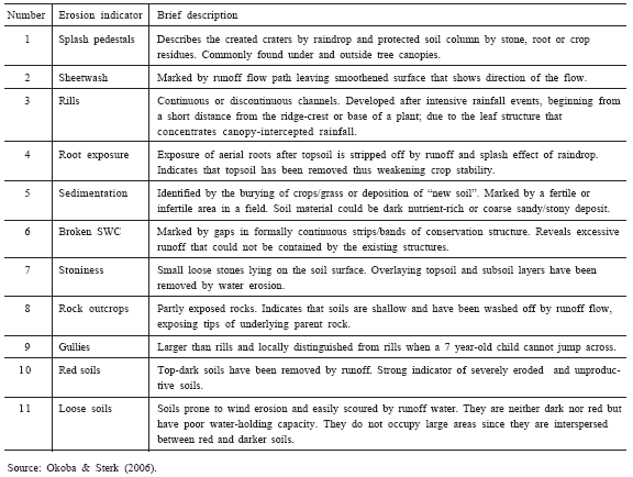
The validation of the USLE application and SLE map for the study area was carried out with soil erosion indicators, following descriptions made in Okoba & Sterk (2006). These authors presented eleven erosion indicators that were identified according to their causes, and which were closely concordant with scientific knowledge. The occurrence of indicators (features) is briefly explained in Table 2, and was surveyed through field incursions. In 100 georreferenced observation points (randomly chosen, where each observation point had approximately 100 to 200 m2) the presence or nonappearance of erosion indicators was investigated along the study area and compared with the soil expectation map through GIS techniques.
Table 2. Description of the erosion indicators frequently found along the study area.
Tabela 2. Descrição dos indicadores de erosão encontrados com freqüência ao longo da área de estudo.
RESULTS AND DISCUSSION
Figure 2 shows the Soil Loss Expectation maps (SLE) for Sorocaba, expressed in six broad classes and ranging from "null - very low" risk areas (< 10 Mg ha-1 y-1) to "very high" risk areas (> 200 Mg ha-1 y-1). As Figure 2, Table 3 also indicates that the predominant class is "null - very low" for the four erosion maps. This class occurred in 79.9% of the 1988 SLE map, in 82.3% of the 1995 SLE map, in 76.8% of the 2003 map and in 76.8% of the 2011 map.
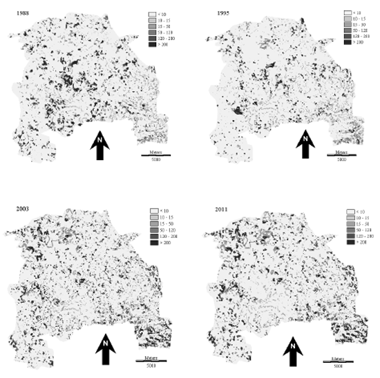
Figure 2. Soil loss expectation maps for Sorocaba (values in Mg ha-1 y-1). In the legend, class "<10" means null/very low soil loss expectation, "10 - 15" means low, "15 - 50" means medium, "50 - 120" means medium / high, "120 - 200" means high and"> 200" means very high.
Figura 2. Mapas de expectativa de perda de solo para Sorocaba (valores em Mg ha-1 a-1). Na legenda, a classe "<10" significa expectative nula / muito baixa, "10 - 15" baixa, "15 - 50" média, "50 - 120" média / alta, "120 - 200" alta e "> 200" muito alta.
Table 3. Percentages of occurrence of each SLE class according to the studied years.
Tabela 3. Porcentagens de ocorrência de cada classe de expectativa de perda de solo conforme os anos estudados.
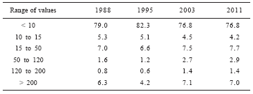
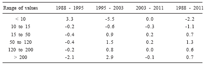
Table 4 indicates that small alterations in the percentage of occurrence of each class have occurred in the investigated period. In general, the two classes that indicate smaller soil loss rates decreased between 1988 and 2011 and the four classes that indicate major soil loss rates increased. This situation is closely linked to areas where bare soils/suburban settlements occurred. These areas were slowly substituted by the "urban settlement" class through the years, causing a decrease in the erosion risk.
Table 4. Percentage increase or decrease for each SLE class according to the considered time interval.
Tabela 4. Percentual de aumento ou diminuição de cada classe de EPS conforme o intervalo de tempo considerado.
Similarly as observed by Sparovek & Schnug (2001) in Piracicaba City (Brazil - 100 km from the study area) and Mati et al. (2000), large and uninterrupted areas of low soil loss values were observed for the land cover classes "pasture" and "forest". On the other hand, highest erosion risk areas were scattered throughout the study area, with some concentrations occurring in the central part of the municipality, as also reported by Cerri et al. (2001) for the Piracicaba River Basin.
Sparovek & Schnug (2001) also mention the average rate of soil formation (-0.0002 m y-1) and the constant value adopted for soil density (1,200 kg m-3). Taking into account these values and comparing with soil loss rates observed in this study, we could suppose that the soil loss rate in Sorocaba is higher that the average rate of soil formation in 94.2% of the area for the 1988 SLE map, 93.9% of the area for 1995, 92.7% of the area for 2003, and will be 91.8% of the area for 2011. Considering these set of values as an indicator of environmental sustainability (Van der Werf & Petit, 2002), we may conclude that, although the soil loss is predominantly low along the study area, the land cover and use of Sorocaba is far from being sustainable.
Table 5 presents the occurrence of erosion indicators in relation to each SLE map class. Almost all observed erosion indicator categories appear predominantly in the SLE class "< 10". This shows the inevitable uncertainties that exist in the erosion mapping, as also reported by Lu et al. (2003) and Oliveira et al. (2007). In the study carried out by Oliveira et al. (2007), the authors did not find high soil loss expectative values in the mapping (also executed using USLE and GIS). However, in many places they registered, photographically, the occurrence of erosion features. They registered the occurrence of rills and sedimentation, two of the most common erosion indicators found in the present study. Here, the occurrence of erosion indicator number 5 (sedimentation) mainly in class"< 10" was not considered a surprise because in areas with plane relief, USLE frequently outputs low values of soil loss, mainly due to LS factor (most markedly the S factor - slope) (Desmet & Govers, 1996).
Table 5. Number of observed erosion indicators in relation to SLE map classes.
Tabela 5. Número de indicadores de erosão observados em relação às classes do mapa de expectativa de perda de solo.
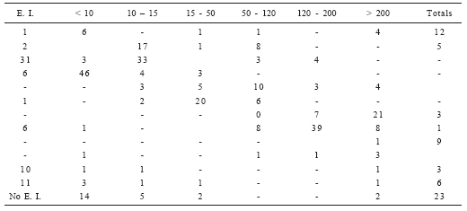
Gullies occurred in three occasions and two of them are directly associated with the mismanagement of the runoff generated in the adjacent highway.
Such apparent inconsistency between erosion mapping and occurrence of erosion indicators along the study area is probably due to the resolution of the digital material used in this study (30 meters) and, on the other hand, the majority of the erosion indicators occured in a relatively small area.
Two erosion indicators that successfully showed a relationship with erosion mapping were sediment delivery ratio in the rivers (Silva, 1999; Lu et al., 2003) and evaluation of loss of soil fertility, the latter especially for sheet erosion that is normally present in rural areas.
As detailed in LRRB (2003), the basic steps to control erosion and sediment loss are the following: 1. Minimize both the area and time that soil is exposed. 2. Manage storm water moving across a site by reducing its speed and volume. 3. Install erosion and sediment control measures early in construction (keep them well maintained). 4. Keep sediment on site. 5. The seeding activity can reduce erosion by 90% in areas under human interventions (urban or agricultural). 6. Maximize vegetation establishment by knowledgeably selecting the appropriate seed, preparing the seedbed, and planting at the right time. Hence, these the first procedures that should be considered to avoid problems of sediment accumulation in streams and also avoid flooding and other related hydrological problems.
CONCLUSIONS
Taking into account the wide spatial diversity and some limitation in the data (especially for erodibility) it was found that in general the USLE successfully predicted the soil loss expectation in the study area. Un-planned urban intensification was considered the most important driving force that accelerated soil loss. The GIS-USLE simulations for 1988, 1995 and 2003 revealed similar general trends - that the erosion risk in most of the city is low and that areas at high erosion risk are localized.
Although these latter areas are scarce compared to the study area, they have a significant negative impact on the soil and water quality of the area, and programs to reduce the erosion risk need to be implemented.
ACKNOWLEDGMENTS
The author is grateful to FAPESP for the financial support and scholarship (grants 04/13096-7 and 04/15796-6) and UNESP / Sorocaba for the logistic support in some parts of the study (mainly field incursions).
BIBLIOGRAPHY
1. Aaviksoo, K. 1995. Simulating vegetation dynamics and land use in a mire landscape using a Markov model. Landscape and Urban Planning 31: 129-142. [ Links ]
2. Boix-Fayos, C; M Martínes-Mena; E Arnau-Rosalé; A Calvo- Cases; V Castillo & J Albaladejo. 2006. Measuring soil erosion by field plots: understanding the sources of variation. Earth- Science Reviews 78: 267-285. [ Links ]
3. Cerri, CEP; JAM Dematte; MVR Ballester; LA Martinelli; RL Victoria & E Roose. 2001. GIS erosion risk assessment of the Piracicaba river basin, Southeast Brazil. Mapping Sciences and Remote Sensing 38(3): 157-171. [ Links ]
4. De Kimpe, CR & JL Morel. 2000. Urban soil management: a growing concern. Soil Science 165(1): 31-40. [ Links ]
5. Eastman, R. 2004. Idrisi GIS software - user's manual. Clark University - Worcester - USA. [ Links ]
6. I.B.G.E. (Brazilian Institute for Geography and Statistic), 2006. (date of consulting), Cidades - o Brasil município por município. Address: www.ibge.gov.br [ Links ]
7. Kirkby, M. 2001. (consulted in September 2006), Physical aspects of soil erosion control. Available at www.geog.leeds.ac.uk/people/m.kirkby/Text_docs/athens121r.doc [ Links ]
8. Jimoh, HI. 2001. Erosion studies in a Nigerian city: a methodological approach. The Environmentalist 21: 97-101. [ Links ]
9. L.R.R.B. (Minnesota Local Road Research Board). 2003. Erosion control handbook. Manual number 2003 - 08. US Department of Transportation. Electronic manuscript. Available at: www.lrrb.gen.mn.us/PDF/200308.pdf [ Links ]
10. Mati, BM; RP Morgan; FN Gichuki; JN Quinton; TR Brewer & HP Liniger. 2000. Assessment of the erosion hazard with the USLE and GIS: A case study of the Upper Ewaso Ngiro North basin of Kenya. JAG 2(2): 78-86. [ Links ]
11. Lu, H; IP Prosser; CJ Moran; JC Gallant; G Priestley & JG Stevenson. 2003. Predicting sheetwash and rill erosion over the Australian continent. Australian Journal of Soil Science 41: 1037-1062. [ Links ]
12. Mitchell, JK & GD Bubenzer. 1980. Soil loss estimation. [Chapter 2 (p. 17 - 62)] In: MJ Kirkby & RPC Morgan, Soil erosion. John Wiley & Sons Ltd. [ Links ]
13. Okoba, BO & G Sterk. 2006. Farmer's identification of erosion indicators and related erosion damage in the Central Highlands of Kenya. Catena 65: 292-301. [ Links ]
14. Oliveira, AMM; SAF Pinto & F Lombardi Neto. 2007. Caracterização de indicadores da erosão do solo em bacias hidrográficas com o suporte de geotecnologias e modelo predictivo. Estudos Geográficos 5(1): 63-86. [ Links ]
15. Oliveira, JB; MN de, Camargo; M Rossi & B. Calderano Filho. 1999. Mapa Pedológico do Estado de São Paulo. Legenda Expandida. Campinas: Instituto Agronômico; Rio de Janeiro: EMBRAPA - Solos, 64 p. [ Links ]
16. Scharrón, CE & LH MacDonald. 2007. Runoff and suspended yields from an unpaved road segment, St John, US Virgin Islands. Hydrological Processes 21: 35-50. [ Links ]
17. SEADE (Fundação Serviço de Análise de Dados do Estado de São Paulo). Date of consulting: 2006. Base de dados da População Paulista. Address: www.seade.sp.gov.br [ Links ]
18. Silva, AM. Submitted. Predicting Land-cover change in the Sorocaba - SP - Brazil. Revista Brasileira de Cartografia, 15 p. [ Links ]
19. Silva, AM. 1999. Aplicação de técnicas de geoprocessamento do estudo das relações entre os processo erosivos e sedimentológicos em bacia hidrográfica. Tese de Doutoramento (EESC - USP), São Carlos, SP, 249 p. [ Links ]
20. Silva, AM. 2004. Rainfall erosion map for Brazil. Catena 57(3): 251-259. [ Links ]
21. Silva, AM & CA Álvares. 2005. Levantamento de informações e estruturação de um banco de dados sobre a erodibilidade de classes de solos no Estado de São Paulo. Geociências 24(1): 33-42. [ Links ]
22. Sparovek, G & E Schnug. 2001. Temporal erosion-induced soil degradation and yield loss. Soil Science Society American Journal 65: 1479-1486. [ Links ]
23. Van der Werf, HMG & J Petit. 2002. Evaluation of the environmental impact of agriculture at the farm level: a comparison and analysis of 12 indicator-based methods. Agriculture, Ecosystems & Environment 93: 131-145. [ Links ]
24. Van Oost, K & G Govers. 2005. (Date of consulting). USLE 2D - software. Available at: http://www.kuleuven.be [ Links ]
25. Verburg, PH; WS Veldcamp; R Espaldon & SSA Mastura. 2002, Modeling the spatial dynamics of regional land use: the clues model. Environmental Management 30(3): 391-405. [ Links ]
26. Wischmeier, WH & DD Smith. 1978. Predicting rainfall erosion losses: a guide to conservation planning. Agricultural Handbook 537. US Department of Agriculture, Washington, DC, 58 p. [ Links ]

