


Servicios Personalizados
Revista

Articulo
 Inglés (pdf)
 Articulo en XML
 Referencias del artículo
 Enviar articulo por email
Indicadores
-
 Citado por SciELO
Links relacionados
-
 Similares en
SciELO
Similares en
SciELO
Compartir

 Permalink
Ciencia del suelo
versión On-line ISSN 1850-2067
Cienc. suelo vol.31 no.2 Ciudad Autónoma de Buenos Aires dic. 2013
TRABAJOS
Effect of temporal resolution of wind data on wind erosion prediction with the revised wind erosion equation (RWEQ)
Juan E Panebianco1* & Daniel E Buschiazzo1, 2
1 Institute for Earth and Environmental Sciences of La Pampa, Nacional Council for Science and Technology (INCITAP-CONICET) and Facultad de Agronomía-UNLPam, C.C. 300, 6300 Santa Rosa, Argentina
2 National Institute for Agricultural Technology (INTA), Exp. Station Anguil, Argentina * Autor de contacto: panebianco@agro.unlpam.edu.ar
Recibido: 11-03-13
Recibido con revisiones: 12-06-13
Aceptado: 23-06-13
ABSTRACT
In wind erosion modelling and assessment, wind speed is a crucial variable. Available records for large regions of the world generally show relatively low temporal resolution. The effect of using wind data of different temporal resolutions in RWEQ discrete and continuous versions was assessed. Wind erosion was measured during 82 high-wind events occurring between 2005 and 2008. Simulated and measured erosion values were compared. For wind erosion simulation during discrete periods, the model was loaded with wind speeds averaged in 5 minutes and 1 hour- intervals. For continuous simulation, a weather file for RWEQ/ 97 was developed and Weibull factors were calculated using both hourly and daily wind speeds. When the discrete version of RWEQ was used with hourly wind speeds instead of five-minute averages, the total simulated soil loss was reduced by 44%. The model efficiency was not significantly affected by wind speed data resolution. RWEQ continuous version, loaded with monthly Weibull parameters using hourly wind speeds, calculated zero erosion. Monthly Weibull distribution scale factors calculated using daily wind speeds were reduced by 32% on average with respect to hourly data. Increasing the Weibull scale parameter by up to 50% slightly improved the monthly simulated erosion rates. Using low resolution wind speed data reduces the model outputs. This may be corrected but a large amount of field information is needed.
Key words. Wind erosion prediction; wind data; wind energy; RWEQ.
Efecto de la resolución temporal de los datos de viento en la predicción de la erosión eólica con el modelo RWEQ
RESUMEN
El viento es la variable fundamental en la simulación de la erosión eólica. A partir de los registros de velocidad de viento, los modelos calculan la energía eólica disponible para producir erosión. En vastas regiones del mundo, los registros de viento presentan una resolución temporal relativamente baja. Se evaluó el efecto del uso de registros de viento de diferente resolución temporal en la versión discreta y continua del modelo RWEQ. La erosión eólica se midió en una parcela experimental durante 82 eventos de viento fuerte ocurridos entre 2005 y 2008. Los valores de erosión simulados y medidos fueron comparados. Para la simulación de la erosión eólica durante períodos discretos, se utilizó una hoja de cálculos conteniendo las ecuaciones del modelo RWEQ. El modelo se cargó con velocidades de viento registradas cada 5 minutos, y promediadas en intervalos de 1 hora. Para la simulación continua se utilizó el modelo RWEQ/97, para el cual se elaboró una base de datos climáticos utilizando registros de viento horarios, y otra utilizando registros diarios. Cuando la versión discreta de RWEQ se utilizó con velocidades del viento horarias en lugar de promediadas cada 5 minutos, la pérdida total del suelo simulada se redujo en un 44%. La eficiencia del modelo no se vio afectada significativamente por la resolución temporal de los registros de viento. La versión continua RWEQ/97 cargada con los parámetros de Weibull mensuales calculados utilizando registros horarios simuló cero erosión. Los factores de escala de la función de Weibull se redujeron en promedio un 32% al utilizar velocidades de viento diarias en lugar de horarias. El incremento de los parámetros de escala de la función de Weibull en un 50% mejoró ligeramente los valores mensuales de erosión simulados. El uso de registros de velocidad de viento de menor resolución tem-poral redujo los valores simulados. La corrección de estos valores es factible, pero requiere de una gran cantidad de mediciones de campo.
Palabras clave. Predicción de la erosión eólica; datos de viento, energía eólica; RWEQ.
INTRODUCTION
Input data resolution can be considered as one of the most critical aspects for modelling wind erosion in any research area. In wind erosion modelling, wind speed is a key variable because the wind energy is the driving force of the erosion process. Stand-alone versions of wind erosion models are simplified versions used for discrete-short period simulations. The full and more complex versions are used for continuous simulation along fixed time steps. In any version, wind speed records are used to simulate the wind transport capacity. Furthermore, wind speed records are used in wind erosion models to calculate the parameters of the Weibull distribution function for simulating wind speeds. Wind erosion models were generally validated and tested at the field level using high temporal resolution wind speed records. However, available records for large regions of the world generally show relatively low temporal resolution.
The importance of using good quality wind speed records for wind erosion modelling was recurrently mentioned (Fryrear et al., 1998; Wagner et al., 1992; Skidmore and Tatarko, 1990). Despite this, the problem of wind data temporal resolution in wind erosion modelling was only assessed by Stetler and Saxton (1997). According to these authors, erosive wind energy is reduced when hourly averages are used instead of one-minute averages. Consequently, the simulated wind transport capacity should also be reduced. Possible consequences of this reduction include underestimations of soil losses, reduced model efficiency, or even inability to predict wind erosion during certain time periods. Underestimation and even no-erosion simulation was reported previously (Funk et al., 2004; Feng and Sharrat, 2007), but wind data temporal resolution has been scarcely considered as a potential cause of this effects. Despite this, different wind erosion models might have different calculation routines, and use different erosive wind energy equations. Hence, a reduction in the resolution of wind speed data should affect the simulated wind energy to a different extent in each model.
The two most widely used models that may require high-resolution wind speed data are the Revised Wind Erosion Equation (RWEQ) and the Wind Erosion Prediction System (WEPS). The discrete version of RWEQ has been used in several places of the world, mainly for experimental purposes, using 1 min (Fryrear et al., 1998; Van Pelt et al., 2004; Visser et al., 2003) and 5 min (Mendez and Buschiazzo, 2010) temporal resolution wind records. The full computer program version of RWEQ was used by Fryrear et al. (2001) while working on site weather data. However, the influence of different temporal resolution wind speed records in RWEQ performance was never analyzed. Skidmore et al. (2006) concluded that WEPS can be used with relatively limited wind data, but they found a reduction in simulated erosion when using only four selected hourly averages per day instead of 24. This reduction could be an indirect evidence of lowered values of the Weibull distribution function parameters.
In many regions of the world, only daily or hourly wind speed averages are available. It is necessary to assess the effects of wind data temporal resolution in wind erosion models performance in order to determine its magnitude, and hence the feasibility of using wind erosion models in regions where only low temporal resolution wind data are available. The objective of this study was to evaluate the effects of using different temporal resolution wind speed data in wind erosion simulation models, comparing simulated values with field measurements.
MATERIALS AND METHODS
RWEQ
Only the basic processes and equations of the RWEQ model are given here. For more detailed information about RWEQ processes and input parameters, please refer to Fryrear et al. (1998). The RWEQ makes estimates of soil transported by wind between the soil surface and a height of two meters for specified periods (Fryrear et al. , 1998). The model calculates aeolian mass transport within the field from the balance between wind erosivity and soil erodibility. Based on field observations of soil movement resulting from windstorms, soil movement is represented by a steady state equation that assumes the existence of a wind transport capacity (Merrill et al. , 1999):
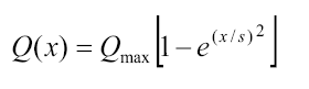
where x is the downwind distance (meters) from the noneroding boundary, Qmax (kg/m) is the transport capacity and s is the distance where 63% of the maximum transport capacity is reached, called the critical field length.
The transport capacity (Qmax) and the critical field length (sp) are determined by several factors:
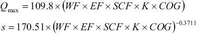
where WF is the weather factor, K ¡s the soil roughness factor, COG ¡s the combined crop factor, SCF ¡s the soil crust factor and EF is the erodable fraction of the soil. The WF is a function of the wind factor (Wf, soil wetness (SW) and snow depth (SD). The wind factor is calculated from wind speed measurements at a height of 2 m and soil wetness is a function of rainfall history and solar radiation. K is a function of oriented and random roughness, measured with the chain of Saleh (1993) and the COG is determined by the dead, lying and standing vegetation cover and the living crop cover (Visser and Sterk, 2005).
Wind erosion measurement
The study site was located in central Argentina, at the Facultad de Agronomía of the Universidad Nacional de La Pampa, Santa Rosa (36°30' S. latitude and 64° 30' W. longitude). The soil of the experimental site was a fine sandy loam Entic Haplustoll with an A-AC-C1-C2k horizon sequence. The organic matter content (Walkley and Black, 1934) of the A-horizon was 1.25%, and the particle size distribution determined with the pipette method (Day, 1965) was: 2000µm - 246µm, 15.7%; 246µm - 104µm, 30.2%; 104µm - 74µm, 15%; 74µm - 50µm, 11.7%; 50µm - 20µm, 9.7%; 20µm - 2µm, 7.4% and <2µm, 10.2%. The standard USDA textural category for this soil is sandy loam.
Wind erosion was measured in a 1 ha square field surroun-ded by a non- erodible boundary during 82 high wind events occurring between 2005 and 2008. The field was tilled periodically with a disk harrow in order to keep it bare and with minimum surface roughness during wind erosion measurements. Annual average soil roughness measured by the chain method (Saleh, 1993) in the field was 1.2%; standard deviation (SD) = 0.45, and visual estimated weed cover varied between 0% and 10%.
Wind erosion in the eroding field was measured with BSNE samplers (Fryrear, 1986) located in four sampling points at the middle of each field. The horizontal mass flux was calculated in each sampling point using an exponential equation proposed by numerous authors (Williams, 1964; Fryrear and Saleh, 1993; Namikas; 2003; Dong and Quian, 2007); the methodology was thoroughly described by Panebianco et al. (2010). The net soil loss for each event was estimated by subtracting the incoming material from the material leaving the field, considering the predominant wind erosion direction. The prevailing direction of the erosive winds was determined for each event by comparing the wind force vectors coming from different directions according to the method described by Skidmore (1965). The threshold wind speed used for calculating erosive energies was 4.9 m/s at 2 meters high, based on the results obtained by de Oro and Buschiazzo (2008) for the same experimental plot.
For each event, soil loss values were calculated considering the distance along the prevailing wind erosion direction between the non-erodible boundary and the sampling clusters located at the edge of the field, to accomplish the definition of soil loss given by Fryrear et al. (1998) for RWEQ. Then, a mean soil loss value for the one-hectare field was computed.
Wind energy
The formula for describing the relationship between erosive wind energy and wind speed used in this study was the one proposed in RWEQ:
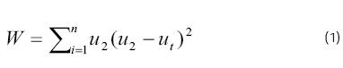
where W is the wind valué (m/s)3; u2\s the wind speed at 2 meters high; ut is the threshold wind speed at 2 meters (5 m/s) and n is the number of wind speed observations during the simulation period.
While in the discrete or static versión the wind speed records are directly entered into the model for computing the wind valué, in the continuous or dynamic versión the RWEQ program computes 500 wind speeds for each period using the monthly Weibull scale and shape parameters (Fryrear eía/., 1998). Wind valúes computed with this equation were used for calculating the RWEQ weather factors (WF) for each wind erosión event.
Discrete simulation
For wind erosion simulation during discrete periods, an Excel® spreadsheet provided by Dr. Zobeck and containing all the basic algorithms used in RWEQ was used. The model was loaded with soil and climate data measured periodically. Following the procedures carried out by other authors (Funk et al. , 2004), a protocol was used for running the model in a more systematic and objective way:
a) Wind angle: Wind angle of prevailing erosive wind allows determining the mean fetch distance to the sampler cluster for evaluating soil loss with the RWEQ Excel® spreadsheet version according to the definition given by Fryrear et al. , (1998). This discrete version does not calculate a median travel distance. Hence, the field distance loaded in the model was 100m if wind angle was 90 degrees (N-S, E-W), 112m if the wind angle was 25 degrees (NNE-NNW, SSE-SSW) and 71m if the wind angle was 45 degrees (NE-NW, SE-SW). Then, a mean soil loss value for the one-hectare field was computed.
b) Soil roughness: Soil random roughness was measured at five points along a NE-SW diagonal using the chain method (Saleh, 1993) at the moment of collecting the wind eroded sediment samples. Unfortunately, it was not possible to obtain roughness data for every event. In the cases where roughness data were missing for an event, a mean roughness value (1.36%) based on all measurements made immediately after a tillage operation was used, and a mean random roughness degradation of 0.03% per day was estimated according to the successive measurements made during the whole sampling period. Oriented roughness similar to field observations (3 cm ridge height and 61cm ridge spacing) was obtained from available databases for erosion models (RUSLE, WEQ, RWEQ) for disk harrows. Due to the scarce presence of ridges and furrows in the field, oriented roughness was kept constant during all the events. Wind angle in relation to tillage direction was loaded for each event according to field data.
c) Vegetative cover: the canopy percent cover for each event was estimated visually.
d) Rain, solar radiation and temperature: When rain occurs, the soil wetness routine is activated and solar radiation values are needed for calculating the potential relative evapotrans-piration, therefore hourly solar radiation was loaded during these cases. Only seven low intensity (<5 mm/h) and amount (<6 mm) rain events were considered for simulation. During these events, erosive winds occurred after the rain; hence the rainfall amount was loaded in the model for simulating the reduction of soil erodibility. Average temperature was loaded for every event because it affects air density.
e) Crusting: If the soil was crusted during a wind erosion event, then a soil crust factor of 0.58 was considered.
Continuous simulation
A weather file for RWEQ/97 containing 19 lines with parameters describing wind speed distributions, wind directions, solar radiation, snow cover and rain data for each month (Fryrear et al. , 1998) was developed. Monthly scale and shape factors for the Weibull distribution function were calculated using hourly averages from a seven-year series (1994-2001) obtained in a meteorological observatory located 500m away from the experimental wind erosion plot. Previously, wind speeds were adjusted to a 10 m-reference height according to:

Where u1 y u2 represent wind speeds at height z1 y z2 respectively (Elliot, 1979). A Weibull distribution function with the calm periods eliminated was used:
![]()
Where F0 = frequency of the calm periods, c = scale parameter (m/s), k = shape or dispersión parameter (dimensionless). Monthly wind speed frequency distributions were based on speed class intervals of 1 m/s, starting in 0.5 m/s (Wagner et al., 1992). The monthly scale and shape parameters were calculated by the method of least squares applied to the cumulative distribution function, as described by Skidmore and Tatarko (1990). According to these authors, the period of historical record should be at least five years in length. The highest temporal resolution, long term (>5 years) wind records for the study site are hourly averages, but the typical temporal resolution of the historical wind speed records for the región are daily averages. For comparison purposes, scale and shape parameters were calculated using both hourly and daily wind speed averages, considering the same seven-year period (1994-2001) and the same study site.
Using monthly averages (1981-1990) from the National Meteorological Service of Santa Rosa, located 8km away from the experimental site, wind erosión forces were calculated for 8 wind directions. The magnitude of each wind erosión forcé vector rj was calculated as:
![]()
where Of is the mean wind speed in each class interval (i), and f. is a duration factor expressed as the fraction of the total observations that occur in the /th direction within the Zth speed class (Skidmore, 1965).
Parallel and perpendicular forces to each direction were calculated as:

where 0 is the angle which indicates the orientation of an imaginary Une representing each direction. The ratio of parallel to perpendicular wind forces for each direction is the preponderance of the prevailing wind erosión direction, symbolized R. The máximum valué of this parameter indicates the prevailing wind erosión direction, while the magnitude of this valué indicates the preponderance of this direction (Skidmore, 1965). Parallel forces coming from opposite directions where calculated in a similar way, according to Skidmore (1965).
Máximum and mínimum temperatures used were obtained from data (1977-2001) recorded 500m away from the experimental plot (Vergara and Casagrande, 2002). Solar radiation (1973-2005) and precipitation (1921-2005) data were obtained from a weather station located at INTA Anguil, 25 km away from the experimental site.
Erosive energy index (EI) was calculated from data recorded at the experimental plot during the wind erosion measurement period. For the calculation of EI, different authors have considered various minimum precipitation intensities but precedents for the studied region do not exist. Hence, precipi-tation intensity considered for the analysis was 5 mm/h, which is the smallest value that has been considered for this calculation according to Colotti (1996).
Rainfall kinetic energy (E) was calculated according to Brown and Foster (1987). The I30 is defined as the maximum intensity registered considering 30-minute intervals during a precipitation event. EI30 was originally calculated using breakpoint rainfall intensity data derived from recording rain gauges. Hence, monthly EI30 values were calculated and transformed for data recorded by automatic weather stations during fixed intervals (5 min.), applying the methodology described by Yin et al. (2006).
RESULTS AND DISCUSSION
Wind data resolution effect on simulated soil losses
When using low resolution (hourly) wind data for calculating wind values (W) with equation (1) for 82 wind erosion events, weather factors (WF) were reduced by 21% on average, in relation to values calculated using high resolution (5 min.) wind data (Fig. 1). All the other parameters and factors (air density, acceleration due to gravity, soil wetness, soil roughness, soil cover, etc) were kept constant, so this reduction was caused by an equivalent reduction (21%) in the erosive wind energy, which is defined in RWEQ as the wind factor (Wf) .

Figure 1. Relative magnitude of weather factors (WF) calculated using wind speed data recorded at different time intervals.
Figura 1. Factores climáticos (WF) relativos calculados a partir de velocidades de viento registradas en diferentes intervalos de tiempo.
These results are similar to those of Stetler and Saxton (1997), who found a reduction of 30% in wind energy values when using hourly data instead of one minute data. The ten-percent difference between Stetler and Saxton (1997) results and those of Figure 1, can be attributed to the use of different minimum temporal intervals (one minute and five minutes, respectively).
The linear correlation between high temporal resolution (WF5min) and low temporal resolution (WF1h) weather factors was high (WF1h = 0.86 WF5min - 0.44; R2 =0.96; p<0.001).
The linear correlation between the simulated soil loss values using high and low temporal resolution wind data showed that for higher wind speed erosion events the correlation tended to be linear, but not for wind erosion events with lower wind speeds (Fig. 2a). When the simulated soil surface was highly erodable (flat, loose and dry), the computed soil loss values tended to follow a linear correlation pattern despite the lowered weather factors (WF1h). The good linear correlation between WF1h and WF5min shows that the wind energy reduction was generally proportional for high and low-wind speed events. Hence, this result reflects the additional effect of the variables that reduce the soil erodibility in simulated mass transport, mainly random roughness and aggregate stability in this study, but also crusting, soil wetness, and vegetative cover.
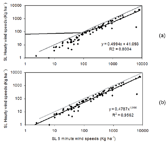
Figure 2. Correlation between RWEQ-simulated soil losses (SL, n=82) using: a) high (5 min) and b) low resolution wind speed data (1hour). Logarithmic scale on both axes.
Figura 2. Correlación entre las pérdidas de suelo simuladas con RWEQ (SL, n = 82) utilizando velocidades de viento de: a) alta resolución temporal (5 minutos), y b) baja resolución temporal (1 hora). Escala logarítmica en ambos ejes.
According to these results, the correlation between simulated soil losses using high and low resolution wind speed data was described by a potential function, as shown in Figure 2b. This means that the protecting effect of variables such as aggregate stability, random roughness, soil crusting, and low vegetative cover becomes proportionally more effective in RWEQ when the simulated wind energy is lower. These results indicate that a wind energy loss produced by the use of hourly instead of 5-minute intervals of wind speed in RWEQ could be corrected using the power function shown in Figure 2b, in order to consider low wind erosion events as well as high ones.
As stated by Stetler and Saxton (1997), wind erosion duration, defined as the number of times that the recorded wind speed is higher than the threshold (5 m/s), is reduced when using lowered resolution wind speed data. Moreover, a reduction in the number of recorded wind speeds not only produces less data but also lower wind speeds (Fig. 3), and this clearly affects the calculated erosive wind energy values.

Figure 3. Effect of time resolution on wind speed data recorded during one wind erosion event.
Figura 3. Efecto de la resolución temporal en los datos de velocidad de viento registrados durante un evento de erosión eólica.
As shown in Figure 1, not in all cases the difference between weather factors calculated with high and low resolution wind data remains proportional. On the other hand, Figure 3 shows that, as indicated by Stetler and Saxton (1997), wind energy contained in wind gusts (maximum wind speeds) is missing in hourly data. For this reason, the observed differences between weather factors calculated with high resolution and low resolution wind speed data can be attributed to the variability in atmospheric stability within the boundary layer, producing different levels of gustiness.
Wind data resolution effect on discrete simulation efficiency
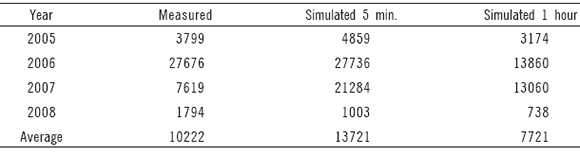
Despite the good correlation between RWEQ simulated soil losses using different temporal resolution wind speed records, and the 21% reduction in the weather factors, annual simulated soil loss was reduced by 43.7% on ave-rage when using low resolution wind speed data (Table 1).
Table 1. Measured and simulated annual soil losses (kg ha-1) using different wind speed resolution records.
Tabla 1. Pérdidas de suelo anuales medidas y simuladas (kg ha-1) utilizando registros de velocidad de viento de diferente resolución temporal.
This was expected due to the simulated geometric increment in mass transport in relation to wind energy increment.
The correlation between simulated and measured soil loss values using five- minute wind speeds can be considered good (r=0.64, p<0.001). According to the Nash Sutcliffe criterion (Nash and Sutcliffe, 1970), the model was more efficient than using a mean soil loss value (NS= 0.34) (Fig. 4a).

Figure 4. Double logarithmic graphs showing the correlation between measured and RWEQ simulated soil loss values using five minute (4a) and hourly (4b) wind speeds (n= 82). The regr ession line shows the deviation from the ideal (1:1) line.
Figura 4. Gráficos doble logarítmicos que muestran la correlación entre los valores medidos y simulados con RWEQ utilizando registros de velocidad de viento de cinco minutos (4a) y de una hora (4b) (n = 82). La regresión lineal muestra la desviación de la línea ideal (1:1).
Finally, the mean deviation (MD) was of -171 kg/ha, reflecting the tendency of RWEQ to overestimation. RWEQ was developed using wind data recorded during severe wind erosion events, so it is expected to better simulate these events and not the smaller wind erosion events which were more frequently observed in this study. In addition, the tendency to overestimate the smaller erosion events might be enhanced by the fact that the model was originally adjusted to field erosion values that were calculated with techniques different from those used in this study. Such differences might have produced higher erosion values than real during some events. These differences in methodologies applied probably produced important variations in mass transport values (Panebianco et al., 2010).
The correlation between simulated and measured soil loss values using hourly wind speeds was similar to the one obtained with higher temporal resolution data (r=0.67, p<0.001), and the model also resulted more efficient than using a mean soil loss value, according to the Nash Sutcliffe criterion (NS= 0.41) (Fig. 4b).
The slight improvement in the determination coeffi-cients and NS indexes when using hourly data resulted from the reduction in wind energy and the consequent improvement of the simulated wind erosion of low magni-tude erosion events, which were preponderant during this study.
Results obtained are very similar to those of van Pelt et al. (2004) who stated that, despite the relatively low correlation between simulated and observed values, their order of magnitude was rather similar. Funk et al. (2004), using the standalone version of WEPS, found correlation coefficients similar to those found in this study, under comparable experimental field conditions. As indicated by many authors, differences between measured and simulated values are due to modelling limitations related to field temporal and spatial variability; for example soil surface roughness or soil crusting (van Pelt et al., 2004; Funk et al., 2004; Visser et al., 2005; Feng and Sharrat, 2006). Some of these differences can be increased when extrapolating empirically-based models to regions different from where they were developed. Nevertheless, the model resulted better, in terms of Nash Sutcliffe efficiency (NS), than using a simple mean soil loss value as an estimator of wind erosion rates.
Wind energy reduction effect on continuous simulation efficiency
Monthly Weibull distribution scale factors calculated using daily wind speeds were reduced by 32% on average with respect to hourly data for the same period and region (Fig. 5a).This reduction in scale factors can be explained by analogy with the erosive wind energy reductions for discrete events. If wind speed is averaged over longer time periods, when grouping wind speeds in speed intervals of 1m/s for calculating Weibull parameters (Wagner et al., 1992, Skidmore and Tatarko, 1990), the occurrence frequency of the higher wind speeds is reduced, producing a decrease in the scale factor of the adjusted probability function. Since the scale factor represents the mean wind speed for any location, this effect will produce lower simulated wind speeds, and consequently lower mass transport in wind erosion models that depend on Weibull distribution function parameters.
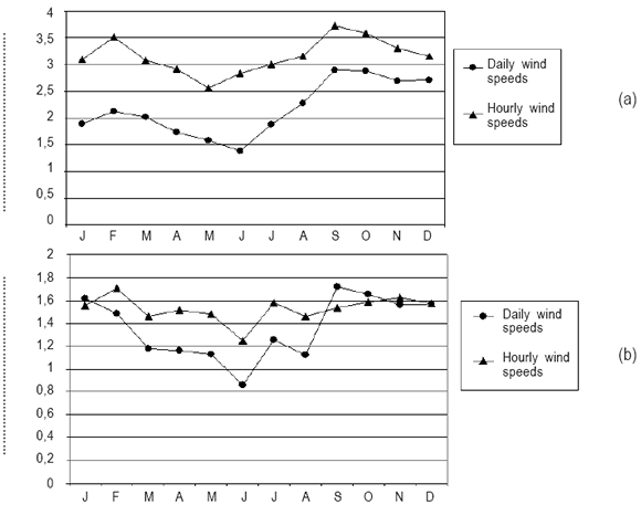
Figure 5. Monthly Weibull distribution function scale (a) and shape (b) parameters for Santa Rosa, Argentina, calculated using hourly and daily wind speeds.
Figura 5. Parámetros mensuales de escala (a) y de forma (b) de la función de distribución de Weibull para Santa Rosa, Argentina, calculados utilizando velocidades de viento horarias y diarias.
The shape parameters of the Weibull distribution function were also affected when using daily instead of hourly averages (Fig. 5b). In this case, not every monthly Weibull shape parameter value was reduced, as the averaged reduction was only 12%. However, during the higher wind erosion risk periods (spring and summer) the parameters were less affected.
When simulating monthly wind erosion for the experimental plot using RWEQ/97 software, zero erosion was calculated, even under low roughness and no vegetative cover simulated conditions (K' varied between 0.25 and 0.08; K'' between 0.24 and 0.08; V values were all equal to 1.00). If a 32% reduction in the scale factors occurred when using daily instead of hourly wind speeds, a considerable wind energy increment in the scale factors should be expected when using five-minute data. Unfortunately, there was not enough continuous five-minute wind data for calculating the Weibull distribution factors for evaluating the wind energy loss with respect to hourly wind data (because high resolution wind data was collected mainly during measurement periods only, and also due to malfunction of the weather station). Hence, considering the 21% wind energy reduction observed when using hourly data during discrete events simulation, Weibull scale factors were increased by 21%. Consequently, the monthly simulated erosion values resulted higher, mainly during spring (Fig. 6), but model efficiency resulted negative (NS = -0.34). When correcting scale factors by 50% instead of 21% (considering the approximately 44% reduction in simulated soil loss when using hourly data with stand alone version), simulated values resulted higher even during summer (Fig. 6), but model efficiency was still low (NS = -0.01; R2=0.06). As discussed in section 3.2, this result can be attributed to modelling limitations (van Pelt et al., 2004; Funk et al., 2004; Visser et al., 2005; Feng and Sharrat, 2006) especially considering the higher complexity of the continuous version compared to the discrete one.
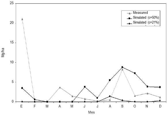
Figure 6. Monthly measured and simulated soil loss with increased monthly scale factors (c).
Figura 6. Pérdida de suelo mensual medida y simulada incrementando los factores de escala mensuales (c).
CONCLUSIONS
The effects of using wind speed data of different temporal resolution in RWEQ performance were evaluated. Wind erosion was simulated with a discrete and a continuous version of RWEQ, and the results were compared with field measurements.
When the discrete version of RWEQ was used with hourly wind speeds instead of five-minute averages, the wind energy was reduced by 21%. Hence, the total simulated soil loss during 82 events was reduced by 44%.
This reduced erosion value still represented 75.5% of the measured soil loss. Nevertheless, the model efficiency for simulating discrete wind erosion events was not significantly affected by wind speed data resolution.
The RWEQ continuous version loaded with monthly Weibull parameters calculated using hourly wind speeds resulted in zero simulated annual erosion, even under very low roughness and vegetative cover conditions. An increase of the Weibull scale parameter by 21% improved the monthly simulated erosion rates, but the model efficiency remained low. A similar result was obtained when increasing scale parameters up to 50%.
Relatively complex wind erosion models were developed using high temporal resolution wind speed records. The model outputs can be corrected, accounting for the reduction in wind energy due to low temporal resolution wind speed records, but this may be misleading unless there is enough field information to compare simulated against measured erosion rates for the studied sites. In regions where wind speed data with a resolution lower than an hour are available, it may be preferable to employ simpler, less demanding wind erosion models for soil conservation purposes.
REFERENCES
- Brown, LG & GR Foster. 1987. Storm erosivity using idealized intensity distributions. Transactions of the ASAE 30: 379-386. [ Links ]
- Colotti, E. 1996. Aplicabilidad de los datos de lluvia horaria en el cálculo de la erosividad. Tesis de Maestría. Facultad de Humanidades y Educación. Universidad Central de Venezuela. Caracas, Venezuela.
- Day, PR. 1965. Particle fractionation and particle size analysis. In: Black, CA (ed.). Methods of Soil Analysis, Part I, Physical and Mineralogical Properties Including Statistics of Measurements and Sampling. ASA, Madison, WI, pp 545-547.
- de Oro, LA & DE Buschiazzo. 2008. Threshold wind velocity as an index of soil susceptibility to wind erosion under variable climatic conditions. Land Degradation and Development 20: 14-21. [ Links ]
- Dong, Z & G Quian. 2007. Characterizing the height profile of the flux of wind eroded sediment. Environmental Geology 51: 835-845. [ Links ]
- Elliot, DL. 1979. Adjustment and analysis of data for regional wind energy assessments. Proceedings of the Workshop on Wind Climate, November 12-13, Asheville, NC.
- Feng, G & B Sharrat. 2007. Validation of WEPS for soil and PM10 loss from agricultural fields within the Columbia Plateau of the United States. Earth Surface Processes and Landforms 32: 743-753. [ Links ]
- Fryrear, DW. 1986. A field dust sampler. Journal of Soil and Water Conservation 41: 117-120. [ Links ]
- Fryrear, DW & A Saleh. 1993. Field Wind Erosion: Vertical Distribution. Soil Science 155: 294-300. [ Links ]
- Fryrear, DW; A Saleh; JD Bilbro; HM Schomberg; JE Stout & TM Zobeck. 1998. Revised Wind Erosion Equation (RWEQ). Wind Erosion and Water Conservation Research Unit, USDA-ARS-SPA Cropping Systems Research Laboratory. Technical Bulletin No. 1.
- Fryrear, DW; PL Sutherland; G Davis; G Hardee & M Dollar. 2001. Wind erosion estimates with WEQ and RWEQ. In: Stott, DE, Mohtar, RH, Steinhardt, GC (eds.), Sustaining the global farm. Selected papers from the 10th International Soil Conservation Organization Meeting held on may 24-29 1999 at Purdue University and the USDA-ARS National Soil Erosion Research Laboratory, pp 760-765.
- Funk, R; EL Skidmore & LJ Hagen. 2004. Comparison of wind erosion measurements in Germany with simulated soil losses by WEPS. Environmental Modelling and Software 19: 177-183. [ Links ]
- Mendez, MJ & DE Buschiazzo. 2010. Wind erosion risk in agricultural soils under different tillage systems in the semiarid Pampas of Argentina. Soil and Tillage Research 106: 311-316. [ Links ]
- Merrill, SD; AL Black; DW Fryrear; A Saleh; TM Zobeck; AD Halvorson & DL Tanaka. 1999. Soil Wind Erosion Hazard of Spring Wheat-Fallow as Affected by Long-Term Climate and Tillage. Soil Science Society of America. Journal 63: 1768-1777. [ Links ]
- Namikas, SL. 2003. Field measurement and numerical modelling of aeolian mass flux distributions on a sandy beach. Sedimentology 50: 303-326. [ Links ]
- Nash, JE& JV Sutcliffe. 1970. River flow forecasting through conceptual models. Part I -A discussion of principles. Journal of Hydrology 10: 282-290. [ Links ]
- Panebianco, JE; DE Buschiazzo & TM Zobeck. 2010. Comparison of different mass transport calculation methods for wind erosion quantification purposes. Earth Surface Processes and Landforms 35: 1548-1555. [ Links ]
- Saleh, A. 1993. Soil surface roughness measurement: Chain method. Journal of Soil and Water Conservation 48: 527-529. [ Links ]
- Skidmore, EL. 1965. Assessing wind erosion forces: Directions and relative magnitudes. Soil Science Society of America Proceedings 29: 602-608. [ Links ]
- Skidmore, EL & J Tatarko. 1990. Stochastic wind simulation for erosion modeling. Transactions of the ASAE 33: 1893-1899. [ Links ]
- Skidmore, EL; C Liao & SJ van Donk. 2006. Simulation of wind speed and direction from limited data. International Soil Conservation Organization Proceedings, Marruecos, may 14-19.
- Stetler, LD & KE Saxton. 1997. Analysis of wind data used for predicting soil erosion. In: Proceedings of the Wind Erosion: an International Symposium/Workshop, 3-5 June 1997. Manhattan, Kansas: USDA-ARS.
- Van Pelt, RS; TM Zobeck; KN Potter; JE Stout &TW Popham. 2004. Validation of the wind erosion stochastic simulator (WESS) and the revised wind erosion equation (RWEQ) for single events. Environmental Modelling and Software 19: 191-198. [ Links ]
- Vergara, GT & GA Casagrande. 2002. Estadísticas agro climáticas de la Facultad de Agronomía, Santa Rosa, La Pampa, Argentina. Revista de la Facultad de Agronomía 13: 74-78. [ Links ]
- Visser, SM; G Sterk & D Karssenberg. 2005. Wind erosion modelling in a Sahelian environment. Environmental Modelling and Software 20: 69-84. [ Links ]
- Wagner, LE; J Tatarko & EL Skidmore. 1992. WIND-GEN: A statistical database and generator for wind data. ASAE meeting presentation. Paper Nº 922111.
- Walkley, A & IA Black. 1934. An examination of Degtjareff method for determining soil organic matter and a proposed modification of the chromic acid titration method. Soil Science 37: 29-37. [ Links ]
- Williams, G. 1964. Some aspects of the eolian saltation load. Sedimentology 3: 257-287. [ Links ]
- Yin, S; Y Xie; MA Nearing & C Wang. 2006. Estimation of rainfall erosivity using 5- to 60-minute fixed-interval rainfall data from China. Catena 70: 306-312. [ Links ]

