


Services on Demand
Journal

Article
 Spanish (pdf)
 Article in xml format
 Article references
 Send this article by e-mail
Indicators
-
 Cited by SciELO
Related links
-
 Similars in
SciELO
Similars in
SciELO
Share

 Permalink
Meteorologica
On-line version ISSN 1850-468X
Meteorologica vol.33 no.1-2 Ciudad Autónoma de Buenos Aires Jan./Dec. 2008
ARTÍCULOS ORIGINALES
Estudio de secuencias secas en la Cuenca del Plata. Implicancias con las sequias.
Gustavo Naumann1,2, Walter M. Vargas1,2 , Juan L. Minetti2,3
1 Departamento de Ciencias de la Atmósfera y los Océanos - UBA
2 CONICET
3 Departamento de Geografía de la UNT Buenos Aires - Argentina
dirección electrónica: gnaumann@at.fcen.uba.ar
Manuscrito recibido el 27 de Febrero de 2009, en su versión final el 30 de Septiembre de 2009
RESUMEN
El trabajo estudia las secuencias secas en el ámbito de la Cuenca del Plata. Los datos utilizados son diarios y pertenecen a 98 estaciones que incluyen periodos variables desde 1900 hasta 2005. El propósito fundamental es caracterizar las secuencias secas y en especial sus casos extremos o sequías meteorológicas en términos diarios. Como marco general se presentan los campos de tendencias de diferentes propiedades de las secuencias secas. A partir de esta información se detectan y comparan cambios temporales en los estados secos. Las tendencias estimadas por dos métodos distintos evidencian un decrecimiento especialmente en el este de la Cuenca en el período común 1972-1998. Finalmente, se analiza la ocurrencia de la sequía de 1988 en escala hemisférica. Esta sequía es una de las más intensas y de mayor extensión que ha ocurrido en gran parte de la cuenca del Río de la Plata. El impacto que este evento produjo en la economía argentina fue mayor a $4 billones de dólares de perdida.
Palabras clave: Secuencias secas; Sequías; Cuenca del Plata
Dry spells in the La Plata basin. Monitoring and trend stability. Drought implication.
ABSTRACT
This paper studies the dry spells observed in the La Plata Basin, using daily data supplied by 98 stations during variable periods between 1900-2005. The main purpose of this study was to define dry spells, especially their extreme cases (meteorologi cal droughts), and to consider them on a daily basis. Trends in over different properties of precipitation and dry spells are presented as a general framework to detect and compare temporal changes in dry states. These trends, estimated by two different methods, show a decrease, especially in the east of the basin during the period 1972-1998. The study of the coherence of extreme dry spell shows that these phenomena occur in subregions reducing the risk of occurrence of one of these events in the entire basin. Also the extreme dry spell occurrence show a seasonal preference suggesting that there is a slight and complex dependence on the annual cycle of precipitation. Finally, the occurrence of the 1988 drought was analyzed in a hemispheric scope. The 1988 drought is considered to be the longest dry spell in the basin. Droughts are studied in detail because water deficits translate to Argentinean economic losses of more than $4 billion dollars.
Keywords: Dry spells; Drought; La Plata Basin.
1. INTRODUCTION
The study of droughts is one of the main concerns of climatology, for it is one of the recurring phenomena with the greatest impact in all areas. The definition of drought is controversial. In same cases, the definitions refer to different systems that are affected by dryness (e.g. agriculture and water resources). Another approach takes advantage of the fact that droughts are local phenomena that affect subregions and that persist for prolonged periods (Dracup et al, 1980). This has led to the development of a number of indices to represent drought situations as in Keyantash and Dracup (2002). The issue of defining droughts that the American Meteorological Society has divided drought definitions and types into five categories: meteorological, climatological, agricultural, hydrological, and socio-economic.
A meteorological drought is one that lasts several months or years, during which precipitation is reduced or absent, and it can develop quickly and end abruptly; in some cases, the transition can occur almost literally overnight. An agricultural drought can result when short-term dryness in the surface layers (root zone) occurs at a critical time during the growing season. Such a drought can severely reduce crop yields, even though deeper soil levels may be saturated. Hot temperatures, low relative humidity, and desiccating winds often exacerbate the impact of the lack of rainfall (Condra, 1944). The onset of an agricultural drought may lag that of a meteorological drought, depending on the prior moisture status of the surface soil layers. Precipitation deficits over a prolonged period that affect surface or subsurface water supply, thus reducing streamflow, groundwater, reservoir, and lake levels, will result in a hydrological drought, which persists long after a meteorological drought has ended. Socioeconomic drought associates the supply and demand of some economic goods with elements of meteorological, agricultural, and hydrological droughts. The relationships among the different types of drought are complex. For example, streamflow is the key variable to analyze in order to describe droughts for many water supply activities, such as hydropower generation, recreation, and irrigated agriculture, where crop growth and yield are largely dependent on water availability in the stream. Consequently, drought has been defined by the international meteorological community in general terms as a"prolonged absence or marked deficiency of precipitation," a "deficiency of precipitation that results in water shortage for some activity or for some group," or a "period of abnormally dry weather sufficiently prolonged for the lack of precipitation to cause a serious hydrological imbalance" (World Meteorological Organization 1975; American Meteorological Society 2003).
Preceding literature on the statistics of dry spells is limited. Papers that could be found have dealt primarily with the length of dry and wet spells (Longley, 1953; Williams, 1952; Feyerherm, 1965 and 1967; Caskey, 1963; Gringorten, 1971; and Gabriel, 1962). One of the goals of studying dry spells is that their absolute maxima would help determine the phenomenon called drought.
In general, from the atmospheric point of view, droughts are mainly studied on a monthly basis or even over longer periods of time. Droughts or extreme dry spells occur over a certain number of days that occasionally may coincide with a month or be included within it. To take a novel approach to drought studies, we decided to work with daily data and to define dry spells and droughts on a daily scale. Another reason for this decision is that, for applications such as risk estimation and the impacts of droughts, it is most convenient to precisely define the lengths of dry spells.
Taking all of this into consideration, the goal of this work is to represent dry states in the La Plata Basin by taking in account only daily data from testing stations in the basin, and then to analyze their dominant structure. The rainfal l deficiency's definition regarding dryness is that of meteorological drought.
In contrast to most existing research on droughts, which is carried out as studies of particular cases and elaborated on monthly to annual scales, this work uses daily precipitation values collecting over a long period to define dry spells on the daily scale.
The objective of this paper is t o carry out an analysis of spatio-temporal variability involved in the different properties of dry events. To perform this analysis some inference about the length of the analysed period were performed. To analyze the dryness events that has the highest impact on the region by considering the evolution of precipitation anomalies in specific droughts, as an approach to monitoring dry events.
2. METHODS AND DATA
Daily rainfall data collected at 98 stations positioned in the La Plata Basin were used. Stations are located in Argentina, Brazil, Paraguay and Uruguay, as shown in Figure 1 and Table I. Data were supplied by the Meteorological Services of the countries and by the Aneel Base (Prosur Project).

Figure 1. Stations used in this study and basin borders in bold line.
Table I. Stations used in this study.

The data were subjected to different levels of internal consistency, according to a variety of publications like the WMO Guides to Hydrometeorological Practices (1970). Only the series that contain less than 10 % of missing data were used.
Reference stations were selected for carrying out specific analyses; these stations contained daily records for at least 50 years, except for the Parana region with records for 20 years.
Dry spells were defined in the same terms as a drought, i.e. an occurrence of consecutive dry days without measurable precipitation. Days with less than 0.3 mm of rainfall was considered dry days. In addition, dry spells in our definition had to occur between wet spells, which were defined as periods of daily rainfall of at least 10 mm. This additional condition took into account the quick runoff and daily evaporation of ~10 mm in this region.
In order to estimate trends, the correlation coefficient (r) between dry spell length and time through coefficient Z (normalized r), which is the quotient between z/zcrict, were calculated. The significance level of r is representative of the slope.


In this work, the confidence level. (a is 5%, using a two sided tail.
We compared the trends of the dry spells length in different periods. Maximum spells were defined as the three maximum dry spells of each year; the average of these dry spells length was also considered.
The years in which the five dryest spells occurred at each of the stations, in the overlapping period between them, were used to measure spatial coherence. The results were compared with those of the complete periods.
Precipitation anomalies were studied, including those occurring during specific droughts at reference points in the region. We represent the lengths and occurrence dates of regional maximum dry spells.
Before studying other details and properties of dry states, we present below some aspects of the rainfall regime in this region. Although this regime has been studied before, we discuss aspects that complement existing studies of droughts.
3. CLIMATIC ASPECTS OF LOW FREQUENCIES IN ANNUAL RAINFALL SERIES
One of the most important aspects in understanding rainfall regime behavior is rainfall at low frequencies, as indicated by trends and the aggregate measure of annual precipitation. As can be observed in Figure 2a, during the longest periods of the stations, trends tend to cause an increase in precipitation in southern Brazil, northwestern subregions of Argentina, and the north of the basin.

Figure 2. Estimation of annual precipitation trends through the statistic Z, with a level of confidence of 5%, for the complete period (a) and for the common period of 1959-1998 (b). Red and blue circle indicates positive and negative significative trends respectively.
Using the common period 1959-1998 of the series in the region (in this case was only used the series that satisfy this period length) and studying the results generated by all stations, we observe that fields in Figure 2b are similar, except in the north of the basin, where significant positive trends disappear in some stations. First, it can be observed that the results of both data collection networks are modified in some regions, though this depends on period length chosen. In other words, in both cases, the regions showing significant positive trends are divided into sectors, although they tend to show the effect of period length in the negative ones.
Similar results are seen when analyzing the annual frequency of rainfall days. In this case, changes in the period length affect specific areas both broadly
and regionally.
In Figure 3 the trends at seasonal accumulated precipitation are shown, where different behavior for the different seasons were found. Only a decrease of the summer precipitation is observed in the North region of the basin, near Rio de Janeiro. In the other seasons it's observed increases in accumulated precipitation in the middle and lower basin. This increase mainly in spring seems to be similar to the observed annual trends.

Figure 3. Estimation of seasonal precipitation trends through the statistic Z, with a level of confidence of 5%, for summer (DJF), autumn (MAM), winter (JJA) and spring (SON). Red and blue ci rcle indicates positive and negative significative trends respectively
In order to compensate for the lack of details in the annual and monthly studies, in the following step other aspects of the climatology of dry spells were studied.
4. CLIMATOLOGY OF THE DRY SPELLS
In order to analyse the series of dry spells for stations with the longest period we select four stations (Campinas (bcampinas), Corrientes (ag000470), Tucumán (ag00tucu) and O.C. Buenos Aires (ag00i156)), we find that these series show little or no persistence and that randomness seems to govern their occurrence (Figure 4). This leads to certain inferences on circulation patterns of dry spells. Analysis of these series shows clearly that most spells last on the order of weeks and that longer spells are uncommon.

Figure 4. Temporal variations of dry spells length in (a) Campinas, (b)Tucumán (c) Corrientes (d) O.C. Buenos Aires.
In addition, these series of spells show certain climatic characteristics. Tucumán, located in north-western Argentina, for example, presents long-term spells, many of which are due to the climatic regime that causes winter droughts in the region. This implies a need for a more detailed seasonal analysis of this station and the region to which it belongs.
From a regional point of view, the estimation of trends of all dry spells shows a particular field in Figures 5 (a) and (b) for the common and complete periods of each station, which reveals the effects of differences of periods between stations and the effects of these differences on trends arising during the same period. A trend towards a decrease in dry spell length is observed in south-eastern Brazil, Uruguay, and the northern Mesopotamian region, with the exception of a region in southern Brazil that borders Uruguay. The addition of total periods reveals the effect of dry spell length on trends, and it also shows the appearance of negative trends in zones where they did not previously exist. We deduce that processes between rains in at the last years are shorter, which implies an increase in low frequencies in the series of dry spells.
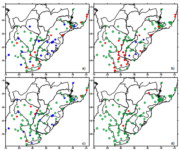
Figure 5. Estimation of the trends of all dry spells by the Z statistic with a confidence level of 5% for the complete period (a) and for the common period 1972-1998 (b) and Estimation of trends of the annual longest dry spell for complete period (c) and common period 1972-1998 (d). Red and blue circle indicates positive and negative significative trends respectively.
It is also important to present variation in terms of means and low frequencies of this property, removing high frequencies in order to highlight interannual variability, evidence of climate change, and other phenomena.
For this purpose, Figure 6 presents the series of annual occurrence of dry spells at four reference stations. From the data we deduce that a year with high frequencies implies higher interchange in meridional flow, whereas one with low frequency may represent less but more intense meridional flow.

Figure 6. Annual occurrence of dry spells in Campinas, Corrientes, Tucumán, and O.C. Buenos Aires
If the four stations with the longest records of annual occurrence of dry spells are analysed (Buenos Aires, Corrientes, Tucumán, and Campinas). It is possible to see that, unlike in Tucumán and Buenos Aires, in Campinas there is no defined trend in this property. If we take into consideration the findings of Minetti and Vargas (1983) regarding variability between the 1940s and 1960s, we see that in Tucumán and Buenos Aires the cooling effect described in this work is reflected in this parameter, which makes the trend and its estimation more complex. In conclusion, the observation of an increase in the frequency of dry spells, together with no decrease in precipitation, suggests that dry spells should be shorter and more numerous.
If long dry spells imply meridional advection in a wide latitude range, processes in the four stations should be coherent over time. Although this is not shown, this does not occur, which indicates that most more frequent meridional advections occur in a narrower latitude range than in the region from Campinas (S23º) to Buenos Aires (S34.5º). This means that deep penetrations of dry air from the north to the south and cold ones from the south to the north in this context are less probable. In addition, there is a closer similarity of regimes between Campinas and Corrientes (S27.4º) than that existing between Tucumán (S26.8º) and OCBA, since spell frequencies are generally higher in OCBA than in Tucumán.
In order to approach the concept of drought (extreme situations of no rain), we found the three longest dry spells per year and their average so as to establish four annual series of so-called meteorological drought.
Figure 7 presents the three maximum dry spells and their average. Dry spell series generally occur randomly at most of the stations, but they present spectral peaks in the lower frequencies, reflecting in some cases the presence of trends (not shown).

Figure 7. Three longest dry spells per year at Campinas (a) and O.C. Buenos Aires (b). longest dry spell (lds), second longest dry spell (2lds), third longest dry spell (3lds) and its average.
To analyse the extreme dry spell regionally (Figure 7), we present two stations located in the north and south of the basin to show that long-term dry spells have negative trends, but that maximum spell grouping is different at the stations, with no specific wavelength common to all stations. Extreme dry spells represented by annual maximum dry spells show significant negative trends, especially in south-eastern Brazil, with no sign of positive trends in any part of the region.
This supports an increase in precipitation in the region at the expense of drought occurrence, such as may be observed in Buenos Aires, where the presence of low frequencies over a long period of time (140 years) is significant in the series of the two extreme dry spells, the average of the three absolute maxima and the absolute maxima.
Again, from a regional point of view (Figure 5 c and d), it can be observed that the increase or decrease of annual longest dry spell is determined by well-defined zones. In addition, the existence of a significant dependence on the period, especially when dealing with low frequency oscillations, can be seen at all stations containing records over the longest period (Figure 5c). In this case, this property is very sensitive to the period length, indicating that as the period increases, new negative trends are found. Given the differences entailed by period length, we conducted a methodological analysis on trends and their implications.
The characteristics of wet spells that indicate the beginnings and ends of dry spells are important when modeling dry spells. Wet spells are also closely related to the definition of drought. One association between the meteorological and hydrological droughts can be performed with the array that represent the longest dry spell per year and the accumulated precipitation of the wet spells that occurs before and after the longest dry spells minus the average daily evaporation (10 mm). In figure 8 can be inferred that the wet spells mentioned above have an accumulated precipitation that less than the average daily evaporation. This result suggests in many cases that the meteorological drought can be associated with a hydrological drought.

Figure 8. Longest dry spell per year (vertical axis) and the array that represent accumulated precipitation of the wet spells that occurs before (horizontal component) and after (vertical component) the longest dry spells minus the average daily evaporation (10 mm) at Buenos Aires. Both positive/negative components indicat ing positive negative/balance.
To complete and expand the analysis, we examine the rainfall and length of wet spells that occur before and after dry spells longer than 15 days. Figure 9 presents the maximum annual dry spells and rainfall associated with wet spells defining the beginning and end of the dry spells. The analysis of all the dry spells longer than 15 days and their associated wet spells reveals that there is no explicit relationship between the wet spells involved, nor is there a relationship between wet and dry spells, as proven by the low significance of the correlation coefficients.

Figure 9. Accumulated rainfall (a) and length of wet spells (b) previous (white) and posterior (black) to the maximum annual dry spells at O.C.B.A.
5. METHODOLOGICAL ASPECTS IN TREND ESTIMATION
One of the most important factors in trend estimation is the choice of period over which to calculate the trend. A trend reflects the effect of waves that are longer than the period of estimation; therefore, a trend may be defined as the sum of the effects of low frequency wave s in the series with periods longer than the recording period. This implies a restricted definition of trends, particularly when trends are calculated over short periods of time (Vargas et al, 2006). In Figure 10, correlation coefficients are shown for two series located in the extremes of the basin. Lapses of estimation begin with the total period up until the last twenty years of each record. Through the examples of Figure 10, it can be inferred that the correlation coefficient is unstable, which implies the existence of low frequency waves that modify the values and natures of trends in various ways, depending on the period chosen.

Figure 10. Estimation of linear trends of annual precipitation for different periods in OCBA (a) and Campinas (b) and significant values at 5% (lines). Periods decrease in 10 years from left to right.
This may be due to the fact that in the time period common to the different testing stations there is no notion of waves with periods larger than the records, and that only fragments of these waves are observed. For this reason, trend values in this work are calculated in two ways: for the same period across all stations and for the total period available at each one of the stations individually.
In this way, another question has to be solved, which is the effect on the trend estimation of some missing information in the series? To do that some modifications over a time series with significant trend and long period were performed over the annual precipitation time series at Buenos Aires:
a: the z statistic over the complete time series was estimated
b and c: ten years were subtracted randomly
d: the five first and last years of the time series are subtracted
The table 2 shown that all Z statistics are significative at 5% confidence level . With this results it's possible infer that the Z statistic maintain its significance if the missing information is less than 10 %. Similar results were found by Vargas et al (2006).
Table II. Z statistic for the four modifications applied to the annual rainfall time series at O.C.B.A in the period 1908-2002. Values of Z greater than 1 are significant

6. ASPECTS OF THE REGIONAL EXTENT OF DRY STATES
One of the problems c oncerning drought impacts and risk factors is the affected surface. How well this can be estimated depends on the density of data collection stations. As since this region is not dense, we chose specific parameters of coherence and simultaneity of occurrence between stations to estimate the regional sizes of droughts. For this reason, we studied the occurrence of the most prolonged droughts at each station, as well as the longest drought during each one-year period.
In this case, we chose to use initially all the basin stations, taking into consideration the shorter records available in the Paraná region (Brazil). Priority was given to regional more than temporal aspects. Figure 11 shows the number of stations where the most prolonged droughts occurred in each year during the period 1972-1998. In 1988, the largest number of stations reported their maximum drought. This indicates a larger i mpact area than that observed in the second most prolonged drought, which occurred in 1995. We analyze the year 1988 in more detail below. It must be reported that according to records on impacts there have been other extreme dry periods during the years 1933 and 1951, especially in the wetland Argentina. In this analysis are not discussed in particular.

Figure 11. Frequencies of the 5 most prolonged droughts in stations of the basin, (for the common period 1972-1998)
Both droughts had important social and economic impacts on the region. Moreover, we note that the second most prolonged drought occurred in the same years in equal proportions as in the previous case. This shows the uniqueness of the year 1988, since the occurrence of two droughts possibly related to the same large-scale physical processes in sub-areas of the region indicates persistence. Despite this double occurrence, the probability of generalized droughts in the La Plata Basin is virtually nil and can be considered unusual. In addition, this involves restricting the area of occurrence and the characteristics of dry states in the region.
As can be clearly noticed in Figure 11, the droughts does not cover the total area of the humid and semi-humid zones of Argentina, not even in the year with the largest quantity of stations reporting drought. This indicates that dry events occur in subregions and rarely over a large percentage of the area. At the same time, it is possible that these frequencies estimate the occurrence of more than one dry state at a station per year.
Therefore, we note that if intensity is proportional to occupied area, drought is very unlikely to occur in most of the productive zone. From a mathematical point of view, an intense meteorological drought will require a low probability of occurrence, meaning that it can be considered an extraordinary event.
Understanding the regional characteristics of extreme droughts and predicting them requires establishing the days on which droughts frequently start or conclude. In this way, we determined the starting days of extreme drought for 12 stations selected from all over the basin for the common period 1972-1998. The Figure 12 shows that extreme droughts occur preferentially in the winter (centred in June and July); in contrast, only a small number of stations reported extreme droughts in the summer or autumn, and practically none in the spring. The results are different for the ending days of extreme droughts; in this case, most ending days occur in the spring. The starting days show a dependence on the annual precipitation cycle, since the minimum of precipitation for most of the region occurs in the winter. We can infer, then, that maximum dry spells tend to interact with variability on an annual scale; in other words, these occur during the monthly minimum of the annual precipitation cycle.

Figure 12. Seasonality of extreme dry spells: starting (black) and final (grey) days
If we consider the entire observation network, despite the gaps in the data collection during certain years, and carry out the same analysis as above for the common period, we note that the 1988 and 1995 droughts show more developed regional characteristics than in the case of the analysis of the common period. This argues that specialized study of those years is needed in order to understand the dominant circulation patterns.
In addition, it is important to note that in considering the five longest spells or the station maximum droughts in the region, only five stations shows two droughts per year. Furthermore, it is implicit that a change in period length may alter the conclusions of the frequency studies.
7. DAILY RAINFALL ANOMALIES
One of the problems faced during modeling rainfall anomalies is the definition of anomaly.
This is particularly evident when dealing with daily rainfall anomaly series in models to analyze dry spells used in hydrology and agriculture. Figure 13 presents the average of daily precipitation calculated with respect to the average daily rainfall of all the days on record and with respect to the rainfall average of rain days at two stations in the basin.

Figure 13. Average of daily rainfall of all the days in the record (dashed line) and with respect to the rainfall average of rain days (solid line) at O.C.B.A. (grey) and Rivera (black).
Small in amplitude, the shape of both annual cycles has a slight trough in winter and peaks in the fall and spring. On the other hand, there is great inter-daily variability. The annual averages of both cycles are between 3 and 12 mm at OCBA, and 4 and 18 mm at Rivera. It must be mentioned that the first series assigns greater importance to the mathematical structure required imposed by the mathematical model, while the second emphasises a physical representation of the rainfall statistic obtained from rainfall values greater than zero. In other words, all the elements in the series should have an equivalent definition. This is fulfilled by the first average, whereas each term in the second average may be the result of quotients with different denominators, or may become a partial series.
We analysed the annual cycles of both daily anomalies: the ones estimated with respect to the average daily rainfall of all the days on record (P*) and those estimated with respect to the rainfall average of rain days (P**).
Three regimes of annual rainfall (dry, normal, and wet) are analyzed at OCBA and Rivera to demonstrate the discrimination possible using annual totals, even though the annual rainfall during the dry period is of the greatest interest for this study. The histograms of both anomalies (not shown) are similar, although as expected the main statistics of the distribution shows some no significative differences in both stations (Table III). The asymmetry reveals that the normal and rainy years are significantly different than the dry years, if P* at OCBA is analyzed. Moreover at Rivera the statistics shown opposite behavior. The kurtosis of P* is greater than P**, indicating the effect of the different properties of the averages. The skew towards greater positive values indicates the difference among the regimes (dry, moist, and normal according of a percentile representation of annual precipitation) and is the result almost exclusively of the strength of the events, rather than the increased frequency. Finally, the statistics for both distributions represent different regimes of precipitation at each station.
Table III. Main statistics of P* and P**for dry, moist and normal years at OCBA (ag00i156) and Rivera (uyrivera).

8. EVENTS IN 1988 IN THE US, ARGENTINA AND BRAZIL
The year 1988 was characterized by extreme droughts in regions important for food and power production in the world. These include the prairies in the United States and the Plata Basin, among others. The mechanisms that caused the event in the US will not be described here and were studied in detail by Trenberth and Guillemot (1996), Trenberth and Branstator (1992), Kalnay et al. (1990) , Chen and Newman (1998) and Liu, Ting, and H. Wang (1998). The main conclusion can be summarized as follows: "...in 1988 disturbances were weaker and displaced far enough to the north to avoid most of the moisture source, and the drought was perpetuated by the dry conditions. Consequently, these effects should be viewed as feedbacks that amplify and prolong the response, while from the standpoint of the atmosphere, the anomalous tropical Pacific sea surface temperatures are a notable (but not the sole) external forcing of the patterns..." That drought took place between April and July, as in the Plata Basin, Namias (1991). However, other months in that year also presented multiple, simultaneous events, although total symmetry is not observed in some months. In the case of the southern hemisphere, and more precisely in southern South America, a strong anticyclonic anomaly was observed, and at the hemispheric level, a disturbance in the easterlies. In any case, the Plata Basin event has not been studied in enough detail and deserves greater attention. A strong La Niña event took place in 1988, which may also be the cause of the events studied here, Palmer and Brankovic, (1989).
The analysis of the evolution of daily rainfall anomalies in 1988 allows a complete description of this drought, as it allows us to estimate the level of soil moisture in each of the sub-regions represented by the stations mentioned in Figure 14. We observe a balance between losses and inputs until March, although these areas experience water deficit due to evaporation. The balance is not general, since the stations in the province of Buenos Aires recorded a water deficit in February.

Figure 14. Cumulative rainfall anomalies at OCBA (black) and Corrientes (grey) for wet years (1959, 1998), 1988 and its average (bold lines).
One remarkable fact is that the stations in central - eastern Buenos Aires receive a cumulative input of 50 - 300 mm in approximately one week. Generalized soil drying continues from March through nearly the end of the year. This water deficit translates to economic losses in Argentina of more than US$4 billion.
Circulation at 1000 hPa, from a NCEP/NCAR reanalysis from May through August (Figure 15), reveals a relative coincidence between the positive and/or normal anomalies in the areas mentioned. Although not included here, geopotential height maps, e.g. at 300 hPa, show similar patterns in both regions. This dominance of subsidence makes it possible to infer humidity, radiation, and soil-drying conditions. The same conditions occur in other months of the year, though not all at the same time. Although not demonstrated here, droughts tend to occur simultaneously during intense La Niña events.
Figure 15. Geopotential height anomalies at 1000 hPa (contours) and specific humidity anomalies at 850 hPa (shaded) in the period May (a), June (b), July (c) and August (d) during the drought of 1988.
Also Figure 15 provides evidence for these statements by showing specific humidity anomalies for those months of 1988. The significant coincidence in the low specific humidity values in the different regions indicates the low availability of atmospheric water during this event.
This example is mentioned because of the importance of both regions for the production of soybean and other crops, and because the 1988 drought caused losses estimated at tens of millions of dollars in the US and thousands of millions of dollars in the Plata Basin.
9. CONCLUSION
The region chosen for this study constitutes, in hydrological terms, one of the most important of the world. However, not always has this region all the necessary detailed information available. With the results of the study, the La Plata Basin counts on a different approach depending on the network, which is partially offset by daily series some of them of great length. The purpose of this study is to provide results, in terms of spells, so as to define droughts in specific conditions as well as to offer syntheses that may be included in models that require it, such as climatic risk estimation, damage attenuation, facilities provision, and management in general. This is visible in several points.
As this is a subject dealing with a very important event, the atmospheric water deficit, an extensive literature exists that exposes a variety of definitions of what is understood by the maximum deficit called drought.
Virtually all of them are conditioned by other systems to which they affect, such as water resources, agrarian and cultural activities. In addition a monthly scale, at a minimum, has been generally chosen to deal with this problem. In each particular case general comparison may be difficult, since data availability, particularly those of soil are not extensive in all countries.
This study shows important characteristics of dry spells and its extreme cases that are necessary for risk estimation in general models of management and for a different elaboration of drought diagnosis, since in this study drought is taken on a daily basis. As a conclusion, it may be s aid that there is a trend towards a decrease in annual occurrence of dry spells lengths, essentially on the east side of the region. This fact is in accordance with annual precipitation total trends and annual precipitation day frequencies. However, after a methodological trail, it is observed that trends are strongly affected by the length of periods. This implies a lower risk of long-term droughts in the region at expense of an increase in precipitation. The dominant process for daily scale dry spells is randomness, which has an impact on the low frequencies where synoptic scale processes are included.
Finally there are two inferences that may be relevant: 1. the study of the coherence of extreme dry spell (drought) occurrence shows that these phenomena o ccur in subregions reducing the risk of occurrence of one of these events in the entire basin. 2 The extreme dry spell occurrence show a seasonal preference suggesting that there is a slight and complex dependence on the annual cycle of precipitation.
Acknowledgments . This research was sponsored by projects UBA X-228 and CONICET PIP 5139.
References
1. Anonymous, 1970. Guide to hydrometeorological practices. WMO 168 T.P. 82, 2nd Edition. [ Links ]
2. Caskey J.E., 1963. A Markov chain model for the probability of. precipitation occurrence in intervals of various length. Monthly Weather Rev. 91, 298- 301 [ Links ]
3. Chen, P., and M. Newman, 1998. Rossby Wave Propagation and the Rapid Development of Upper-Level Anomalous Anticyclones during the 1988 U.S. Drought. J. Climate , 11, 2491-2504. [ Links ]
4. Condra, G. E., 1944. Drought, it effects and measure of control in Nebraska. Nebraska University, Conservation and Survey Division, Conservation Bulletin 25. [ Links ]
5. Dracup, J. A., K. S. Lee, and E. G. Paulson, Jr. 1980. On the definition of Droughts. Water Resources Research 16, no. 2: 297-302. [ Links ]
6. Feyerherm A.M and L.D. Bark, 1965. Statistical Methods for Persistent Precipitation Patterns. J. Appl. Met. 4, 320-328 [ Links ]
7. Feyerherm A.M and L.D. Bark, 1967. Goodness of Fit of a Markov Chain Model for. Sequences o f Wet and Dry Days. J. Appl. Met. 6, 770-773 [ Links ]
8. Gabriel, K. R. and Neumann, J 1962. A Markov chain model for daily rainfall occurence at Tel - Aviv. Quart. J. R. Met. Soc., 88, 90-95. [ Links ]
9. Gringorten I.I., 1971. Modeling conditional probability. J. Appl. Meteor., 10, 646-657. [ Links ]
10. Kalnay, E., Kanamitsu, M. and Baker, W. E. 1990. Global Numerical Weather Prediction at the National Meteorological Center. Bull. Am. Meteorol. Soc. 71,1410-1428. [ Links ]
11. Keyantash, J. and J.A. Dracup, 2002. The Quantification of Drought: An Analys is of Drought Indices. Bull. Amer. Meteor. Soc., 83 (8), 1167-1180. [ Links ]
12. Liu, A.Z., M. Ting, and H. Wang, 1998. Maintenance of Circulation Anomalies during the 1988 Drought and 1993 Floods over the United States. J. Atmos. Sci., 55, 2810-2832. [ Links ]
13. Longley R. W., 1953. The lenght of dry and wet periods. Quat. J. Roy: Meteor. Society. 79, 520. [ Links ]
14. Meteorological Drought (Adopted by AMS Council on 23 December 2003), Bull. Amer. Met. Soc., 85 [ Links ]
15. Minetti, J.L., W.M. Vargas, 1983. El enfriamiento de la década de 1950 en la República Argentina. Meteorológica. Vol. XIV. Nº 1-2, 175 - 188. [ Links ]
16. Namias, J., 1991. Spring and Summer 1988 Drought over the Contiguous United States- Causes and Prediction. J. Climate, 4, 54-65. [ Links ]
17. Palmer, T. N., and C. Brankovic, 1989. The 1988 United States drought linked to anomalous sea surface temperature. Nature,338, 54-57. [ Links ]
18. Hounam, C.E. Burgos, J.J., Kalik, M.S., Palmer, W.C., Rodda, J., 1975. Technical Note No. 138. Drought and Agriculture (Report of the CAgM Working Group on Assessment of Drought). WMO No. 392, 127 pp. [ Links ]
19. Trenberth, K. E., and C. J. Guillemot, 1996. Physical processes involved in the 1988 drought and 1993 floods in North America. J. Climate, 9, 1288-1298. [ Links ]
20. Trenberth, K. E., and G. W. Branstator, 1992. Issues in establishing causes of the 1988 drought over North America. J. Climate 5, 159-172. [ Links ]
21. Vargas W. M., G. Naumann y J. L. Minetti, 2006. Las Tendencias de la temperatura máxima y mínima en Series de Referencia del Sudeste de Sudamérica. Aspectos metodológicos. Revista de Geografía, VIII, Nº 10, 67-74. [ Links ]
22. Williams C. B., 1952.Sequences of wet and of dry days considered in relation to the logarithmic series. Quat. J. Roy: Meteor. Society. 78, 335 91- 96 [ Links ]

