


Services on Demand
Journal

Article
 English (pdf)
 Article in xml format
 Article references
 Send this article by e-mail
Indicators
-
 Cited by SciELO
Related links
-
 Similars in
SciELO
Similars in
SciELO
Share

 Permalink
Latin American journal of sedimentology and basin analysis
On-line version ISSN 1851-4979
Lat. Am. j. sedimentol. basin anal. vol.19 no.2 La Plata July/Dec. 2012
ARTICLES
Hydrosedimentological studies in the paciencia dam, southeastern Brazil
Jefferson V. Bandeira 1, Vinícius V. M. Fereira 1, Lécio H. Salim 1, Namir de S. Vieira 1, Marina S. M. Meneghini 1, Denise M. Sales 1, Marília V. Junqueira 2, Marcela D. de Carvalho 3 and Helen R. Mota 3
1 CDTN - Development Center of Nuclear Technology. Av. Antônio Carlos 6627, Campus UFMG - CEP 31270-901, Belo Horizonte - MG - Brasil. vvmf@cdtn.br, jvb@cdtn.br, salimlh@cdtn.br, nsv@cdtn.br, msmm@cdtn.br, dms@cdtn.br
2 CETEC - Technological Center of Minas Gerais. Av. José Cândido da Silveira, 2000, Horto - CEP. 31035-536, Belo Horizonte - MG - Brasil. marilia.junqueira@cetec.br
3 CEMIG - Energetic Company of Minas Gerais. Av. Barbacena, 1200, Santo Agostinho - CEP 30190-131, Belo Horizonte - MG - Brasil. marcela.david@cemig.com.br; helen.mota@cemig.com.b
Abstract:
The utilization of dams for many purposes, such as water supply, navigation, flood control, irrigation, storage of water and generation of electricity, among others, solves several problems but unfortunately creates many others. Water management is not a simple task, and the presence of dams generates social, physical, chemical, biological and environmental consequences. Among these severe impacts associated to the implantation and operation of dams, the issues related to the transported and deposited sediments are very significant, although many times hard to evaluate. The objective of this paper is to present the results of studies performed close to the dam of a small hydro power plant located in the Paraibuna River, in the southeast part of Brazil. A grain size analysis of the sediments and its chemical characterization were evaluated before and after a bottom discharge. Two bathymetric surveys in a section of 1.6 km upstream the dam were also performed, one just before and other just after the bottom discharge, in order to evaluate its influence in the bathymetry of the river. The results showed that after the bottom discharge, the amount of muddy sediments upstream the dam became smaller. Regarding to the heavy metal content, the bottom sediments collected upstream and downstream the dam presented, in several samples, values higher than the threshold above which a probable adverse effect on the biota is expected, in particular for cadmium, chromium and zinc, in order of importance.
Keywords: Sedimentation; Bottom discharge; Environmental evaluation; Paciência dam; Brazil.
Resumo:
A utilização de barragens para diversos fins, tais como abastecimento e armazenamento de água, navegação, controle de cheias, irrigação e geração de energia elétrica, entre outros, resolve vários problemas, mas, infelizmente, cria muitos outros. A gestão da água não é uma tarefa simples, e a presença de barragens gera consequências sociais, físico-químicas, biológicas e ambientais. Entre os vários impactos associadosà implantação e operação de barragens, as questões relacionadas ao transporte e deposição de sedimentos são muito significativas, embora muitas vezes difíceis de avaliar. O objetivo deste trabalho é apresentar os resultados de estudos realizados próximo à barragem de uma pequena usina hidrelétrica localizada no Rio Paraibuna, na parte sudeste do Brasil. A granulometria dos sedimentos e sua caracterização química foram avaliadas antes e após uma descarga de fundo. Dois levantamentos batimétricos em uma seção de 1.6 km a montante da barragem foram também realizados, um logo antes e outro logo após a descarga de fundo, para avaliar a sua influência na batimetria do rio. Os resultados mostraram que, após a descarga pelo fundo, a quantidade de sedimentos finos a montante da barragem tornou-se menor. No que se refere à presença de metais pesados, os sedimentos de fundo coletados a montante e a jusante da barragem apresentaram, em diversas amostras, valores superiores ao limiar acima do qual efeitos adversos na biota são esperados, em particular para o cádmio, chumbo e zinco, em ordem de importância.
Palavras chave: Sedimentação; Descarga de fundo; Avaliação ambiental; Barragem de Paciência; Brasil.
Introduction
Sedimentation is one of the main causes of the environmental problems that happen each time a dam is built (Ibanez et al., 1998; Dauble et al., 1999; Sear, 1995). For example, due to the dams, the Mississippi River transports only half of its original load of sediments, contributing to the extensive loss of cultivable lands in the American State of Louisiana (Ferreira et al., 2007). In the 1930s, the Colorado River transported about 125 to 150 million tons of sediments to the delta in the Gulf of California. However, due to the construction of dams along the river course, a reduced flow of essential nutrients now reaches the agricultural areas downstream, which causes loss of land production. Also, other consequences in this basin were changes in the salinity regime, reduction in the diversity of local fauna species and increase in the concentration of chemicals and toxic substances such as mercury (Ferreira, 2004).
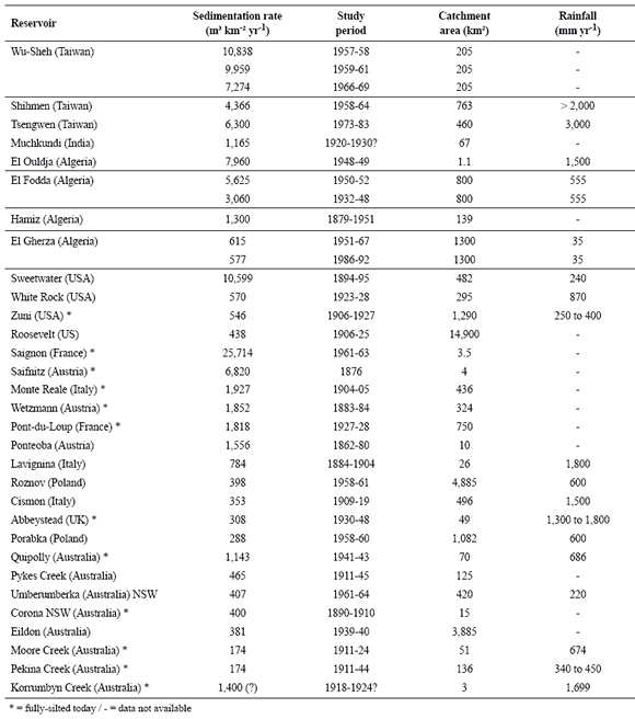
In other example, sedimentation caused the reduction of 80% of the capacity of the Anchicaya reservoir in the State of Columbia, USA, whose original volume was five million cubic meters (LePreste, 1989). Studies conducted some years ago in 17 major reservoirs in India showed a sedimentation rate three times higher than expected, like the Kotapalli reservoir that reduced 55.7% of its operational volume due to sedimentation (Reddy, 2002). In Egypt, the suspended sediment concentration was measured during the period 1968-1979, to evaluate the sediment transport along the Aswan High Dam Reservoir. The results showed that the average annual rate of sediment inflow was 130 million tons, and the average annual rate of outflow was only 6 million tons (Shalash, 1982). In fact, the problems and effects of the Aswan Dam are seen, until today, as a major challenge for the Egyptian society (Tortadaja et al., 2012). Chanson and James (2006) reviewed some data related to silting problems in many reservoirs, showing that severe sedimentation problems can be observed all around the world (Table 1). It can be seen that in some cases, extreme sedimentation rates cause the reservoir to fall into disuse.
Table 1. Examples of extreme reservoir sedimentation rates (Chanson and James, 2006).
The here studied Paciência small hydro power plant (SHP) is located in Matias Barbosa, State of Minas Gerais, Brazil (Fig. 1). It operates in the Paraibuna River, which is part of Paraíba do Sul hydrographic basin. It started its operations in 1930, and today it is controlled by CEMIG - Energetic Company of Minas Gerais. The height of the dam is 9 m, and no lake was built for its operation. The powerhouse has three generating units, totaling an installed capacity of 4.08 MW.
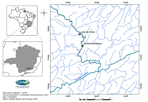
Figure 1. Location of Matias Barbosa and of the Paraibuna River.
The Paraíba do Sul hydrographic basin is located in southeastern Brazil. It has a total area of 55,400 km², a length of 1,150 km and supplies water to over 180 municipalities, what represents about 8.7 million people (Pinto et al., 2009). The vegetation in the basin is severely impacted due to the occupation and land use, resulting in erosion and sedimentation of the rivers. Nowadays, the most notorious and damaging sources of pollution in the basin are domestic sewage, agricultural effluents and solid waste from the cities located along the rivers course, mainly those ones that come from Juiz de Fora, the biggest city in the area which has an important industrial park. The considerable population growth and the intense and diversified industrial development in the past decades in the region are reflected in the quality of the waters of the basin (Soares et al., 2010). The Paraibuna River supplies 600,000 people, and studies done in the area found that the average value of its flow ranges from 16 to 42 m3 s-1, although in extreme cases it reaches values much higher (Ribeiro, 2007). According to the data of a sedimentometric station located in the Paraibuna River, close to Paciência SHP, the annual suspended sediment load measured after a ten years study was 53,049 ton, considering a drainage area of 971 km2. These data was obtained for an average flow of 20.40 m3 s-1 and considering 82.50 mg l-1 as the historical average concentration (SERLA, 1997).
In 2010, a research project named "Environmental evaluation of the Paraibuna River, downstream the dam of the Paciência SHP, after the bottom discharges", supported by CEMIG and National Agency of Electrical Energy (ANEEL) was endorsed. The Development Center of Nuclear Technology (CDTN) and the Technological Center of Minas Gerais (CETEC) were the institutions that conducted the field procedures. A bottom discharge is done twice a year in the SHP.
It is worth mention that the transported sediment in the aquatic environment is an important parameter in the management of watersheds. According to an IAEA (International Atomic Energy Agency) technical report, in general about 90% of this transport occurs in the form of suspended sediments within the liquid mass (Forstner and Schoer, 1984). The muddy sediment (< 0.063 mm) moves primarily in suspension and is an important vector in the transport of metals and other pollutants as well of organic matter in the aquatic environment due to the preferential adsorption of these elements to the muddy sediment (Carvalho, 1994).
The goal of this work is to present the results of hydrosedimentological studies done in the region where the Paciência SHP is located. In particular, the performed studies evaluated, before and after a bottom discharge, the grain size of the sediments and its chemical characterization, together with two bathymetric surveys in a section of 1.6 km upstream the dam. The obtained results showed the depths along the reservoir and helped to estimate the sedimentation rate of the dam.
Methods
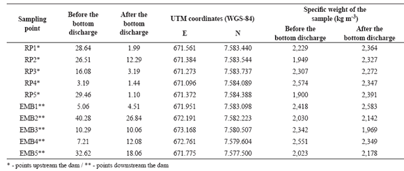
Sediment analysis included two field campaigns done in 2011 to collect the bottom river sediments. The first one was made before a bottom discharge of the Paciência SHP performed in June, and the second one two days after its discharge. The bottom sediments were collected in ten sampling points along the Paraibuna River, in five locations upstream and five points downstream the dam. The ten samples were stored in glass vials, cooled, and transported to CETEC, in Belo Horizonte, for grain size analysis and determination of heavy metals levels, organochlorine pesticides, polycyclic aromatic hydrocarbons, total organic carbon and nutrients. The results were compared to the values exposed in the Resolution 344/2004 of the Environment National Council (CONAMA - Resolution 344/2004), which establishes the general guidelines and the minimum procedures for evaluating the material to be dredged in Brazilian waters. The bottom discharge of reservoirs is a form of dredging.
The specific weights of the dry samples were estimated in the laboratory. The specific weight of water is known and equal to 1,000 kg m-3. To estimate the value of the specific weight of wet sample "in situ" it is necessary to use samplers that do not deform the sample or by means of nuclear equipment. To cover this gap, an average value of 1,600 kg m-3 was used. This value is based on dredging works done by the CDTN using nuclear equipment, where several measurements were performed (Minardi, 1984). The weight of the muddy sediments and sand dumped downstream were calculated based on the measurement of the volume and concentration of samples collected downstream.
The two bathymetric surveys conducted before (June 1st) and after (June 18th) the bottom discharge, took place between the SHP and a concrete bridge located 1.6 km upstream the dam, along the course of the river (Fig. 2). In the bathymetric surveys the displacement of the boat used in the studies followed a perpendicular route along the longitudinal axis of the river, at an average speed of 0.40 m s-1. A limnimetric scale located in the Paciência dam was adopted as a reference to correct the depths. In both cases - after and before the discharge -, the scale was read every 30 minutes.

Figure 2. River section where the bathymetric studies took place and location of the five sampling points upstream the dam- RP1 to RP5 (Source: Google Earth)
The bathymetric surveys were performed through four main equipments: a small motorized boat (6 m long, 0.20 m draft and flat bottom), a DGPS positioning system, an echo sounder and a notebook. To monitor the depths, an echo sounder SENBON DENKI model PDR-130, made in Japan, was used. It operates at 12 V DC provided by a common battery. Although this equipment possesses an analog depth recorder, which prints the data on a continuous heatsensitive paper, a notebook was also used to collect and store the available data in digital form, in order to expedite the processing of data (Bandeira et al., 2011a).
The transmitter-receiver system (transducer) of the echo sounder, encapsulated in stainless steel, emits a signal in a standard frequency of 200 kHz, and it was engaged on board the boat at 0.20 m below the water level. Since the speed of sound in water is already known, the determination of the depth of the water course system is based on the elapsed time between emission and reception of echo signal after its reflection at the bottom. The correspondence between depth measurements and geographical position of the measure allows the achievement of a set of geographically referenced depth. Thus, in parallel to the operation of the echo sounder, a DGPS positioning system (Differential Global Positioning System satellite), model Mobile Mapper (Thales Navigation) was used. Compared to the traditional GPS (Global Positioning System), the differential system improves the precision of the coordinates, correcting systematic errors that are caused by extrinsic receptors. Among these errors are those caused by signal delays in the atmospheric layers, the effects of reflected signals and receiver noise.
The operating principle of the differential system, which consists of two satellites communication units, corrects the position recorded by a mobile receiving station, placed in the boat, taking as basis the corrections generated in a base station situated on land at a point of known coordinates. Currently, IBGE - Brazilian Institute of Statistics and Geography, has a network of base stations throughout the country. Thus, for correcting the position of the boat, the closest IBGE base station, located in the city of Rio de Janeiro, was considered as the reference to optimize the data. In the two bathymetric surveys conducted, the horizontal datum used was WGS84 (World Geodetic System) and, as a system of coordinates, the UTM (Universal Transverse Mercator) was adopted. The positioning data stored in digital format by the DGPS receiver located on the boat, along with the base station data provided by IBGE, was processed by a software named MMOffice (Thales Navigation). This computer program fix the position of the vessel referenced to the data from the base station. The result is a database of the vessel position, corrected and available each second (Bandeira et al., 2011b).
The processing of the depth data, monitored and stored in a notebook every second, consisted mainly in reducing the values to a same datum reference, defined as the share of 505.00 m of the limnimetric scale located at the dam. So, a XYZ data file was built, consisting of the coordinates of the position of the vessel versus the depth.
The software SURFER, version 9.7 (Golden Software Inc.), was used for the production of plants that correspond to the bathymetric surveys conducted on 06/01 and 06/18, between the dam and
a concrete bridge. This software aims to interpolate spatially irregular XYZ data into a grid of spaced data, which allows the calculation of areas and volumes, the construction of graphs and contours of three-dimensional surfaces. For the bathymetric surveys conducted, an interpolation method called "Natural Neighbor", which allows a good fidelity to the original data, was used. The studied area was spit in six sections, and the program SURFER was used to calculate the volume of each section. In possession of the area of each one of the six segments of the reservoir, the average depth in each section was estimated dividing the volume of each one by the superficial area that corresponds to the surveys conducted before and after the bottom discharge To calculate the quantitative size order of the muddy sediments and sand, provided by each sector, and also the total, dumped downstream the dam, it is necessary to know the values of concentration of solid material in different sectors. This was obtained using the following equation (Bandeira et al., 2011b):
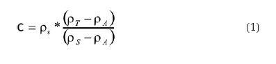
where C = concentration (kg m-3);
ρS = specific weight of the dry sample (kg m-3);
ρA = specific weight of water (kg m-3);
ρT = specific weight of the wet sample "in situ" (kg m-3)..
Results
Sediment Analysis
The level of muddy sediment (< 0.063 mm) fell drastically after the bottom discharge in most of the sampling points. The results presented in Table 2 show that after the discharge, the amount of muddy sediments collected in the sampling points become smaller. This indicates that a major quantity of muddy sediments was carried downstream the dam in the process. It can be observed that the reduction of muddy sediments is much more important upstream, since the dams avoid their natural flow along the river course. To understand the dynamics of sediments downstream the dam, additional studies are being done with the help of radioactive (technetium 99) and fluorescent (rodamine WT) tracers. The dispersion of the marked sediments in the Paraibuna River was monitored by nuclear probes. Preliminary observations indicate that the morphology of the river, including its declivity and the presence of dead zones, could answer the questions associated to the deposition of the sediments downstream.
Table 2. Percentage by weight of sediments passing through a 0.063 mm sieve (muddy sediments).
It is worth emphasizing that the transport capacity of the sediments by the river is another important factor that explains its dynamics. The transport of sediments in a watercourse is a function of its velocity, however there is a maximum capacity that can be carried. After the saturation limit is achieved, a watercourse cannot carry more sediment, even if there is an increment in the velocity of the waters (Tucci, 1993). Figures 3 and 4 show the changes in the grain size of bottom sediments before and after the bottom discharge.
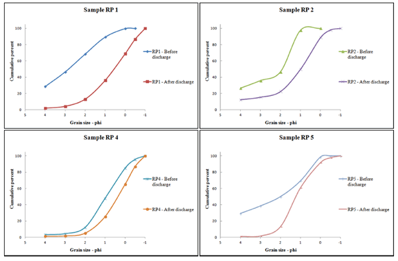
Figure 3. Grain size distribution of samples located upstream the dam before and after the bottom discharge.
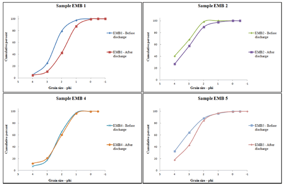
Figure 4. Grain size distribution of samples located downstream the dam before and after the bottom discharge.
Chemical analysis was done in order to characterize the collected bottom sediments. The parameters evaluated were the total organic carbon, total volatile solids, total phosphorus and total Kjeldahl nitrogen of the collected samples. Table 3 shows the obtained results.
The CONAMA Resolution 344/2004 establishes the reference values for total organic carbon, total volatile solids, total phosphorus and total Kjeldahl nitrogen of the material to be dredged, in order to support its management in the disposal area. The alert values for these parameters are:
- Total organic carbon: 10%
- Total phosphorus: 2,000 (mg kg-1) = 0.20%
- Total Kjeldahl nitrogen: 4.800 (mg kg-1) = 0.48%
Table 3. Total organic carbon and nutrients of the samples collected before and after the bottom discharge.
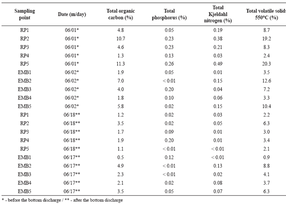
According to this legislation, it can be seen that in the obtained results before the bottom discharge (Table 3), some values are higher than the reference values listed above.
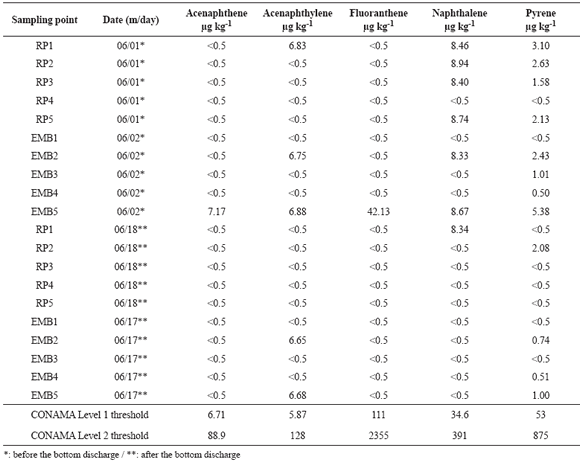
Chemical characterization, according to CONAMA, shall determine the concentrations of pollutants in the sediments (heavy metals, total organic carbon and nutrients) of the material that can be dredged. Regarding to the heavy metal content, Table 4 shows that the bottom sediments collected upstream and downstream the SHP present, in several samples, values higher than Level 2 (threshold above which a probable adverse effect on the biota is expected) for the elements Cd (cadmium) Cr (chromium) and Zn (zinc), in order of importance. Considering the Level 1 (threshold below which a low probability of adverse effects to biota is expected), the vast majority of the samples were greater than these values. Only in relation to As (Arsenic) all samples show levels smaller than Level 1. It is valid to observe that CONAMA reference values are presented in the last two lines of Table 4.
Table 4. Content of heavy metals of the samples collected before and after the bottom discharge.

In the ten sampling points, the level of organochlorine pesticides present in the sediments samples was also evaluated. Due to technical reasons, it was not possible to test the level for polychlorinated biphenyls. The pesticides analyzed were: BHC, DDD, DDE, DDT, Endrin, Dieldrin and Chlordane. Several pesticides that are not in the list of CONAMA were also tested, like Alachlor, Aldrin, Atrazine, Bromacil, Butachlor, alfa Endosulfan, beta Endosulfan, Endosulfan sulfate, Endrin aldehyde, Endrin ketone, Heptachlor, Heptachlor epoxide, Metolachlor, Methoxychlor, Prometon and Simazine. In all samples, the obtained levels were smaller than 1 μg kg-1, what agree with the requirements of CONAMA.
Other important pollutants to be measured are hydrocarbons, in this case the results of the analysis done for polycyclic aromatic hydrocarbons (PAHs) in the sediments are shown in Table 5. The PAHs were divided by CONAMA in two different groups: "alternant" (A) and "nonalternant" (B). The distinction is based on the electron density associated with the molecule. According to the United States Department of Health and Human Services (HHS), "alternant PAHs have an equally distributed electron density, whereas nonalternant PAHs behave almost as if they were two different molecules because of an uneven distribution of electron density from one portion of the molecule to another. The toxicological significance of this difference is that alternant and nonalternant PAHs appear to behave differently, for example, with regard to how they are metabolized to ultimate carcinogens" (HHS, 1995). It can be observed that only sample EMB3 presents a result that does not match the CONAMA requirements for group A - 106,41 μg kg-1 for Dibenz [a,h] anthracene (the limit is 6,22 μg kg-1).
Table 5. Levels of alternant PAHs in sediments collected before and after the bottom discharge.
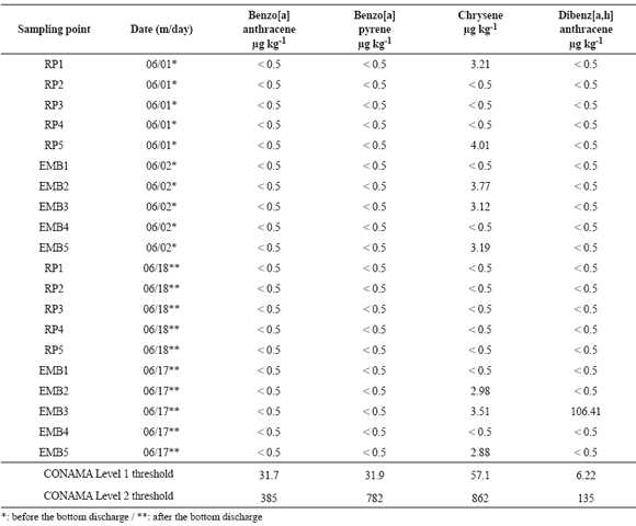
Table 6 shows the results for group B. The results of the analysis done for Anthracene, Phenanthrene and Fluorene were suppressed from the table since for all samples those values were very close to zero. Due to technical reasons it was not possible to evaluate only the level of one PAH in the samples: 2 methylnaphthalene. No found values were bigger than CONAMA Level 2. The reference values of CONAMA 344/2004 Resolution for fresh water are presented in the last two lines of Tables 5 and 6.
It can be seen that samples EMB2 and EMB5, before and after the bottom discharge, present an Acenaphthylene level slightly above the CONAMA Level 1 threshold (5.87 μg kg-1). For the sample RP1 this fact happens only before the discharge. For EMB5, before the bottom discharge, the level of Acenaphthene is also superior to CONAMA Level 1 threshold. EMB 3 has a higher level than Level 1 for Dibenz [a, h] anthracene after the bottom discharge. For the other PAHs in all samples, the levels were always below those ones present in CONAMA Resolution 344/2004.
Table 6. Levels of nonalternant PAHs in sediments collected before and after the bottom discharge.
Also, given the obtained values of organochlorine pesticides and PAHs in the bottom sediment sampled in the region upstream and downstream the Paciência SHP, before and after the bottom discharge, it is possible to see that these pollutants have values always below the CONAMA Level 2 threshold.
Bathymetric Survey
The order of the average net volume of the section of the river under study, calculated by the program SURFER to the survey conducted in June 1st, before the bottom discharge, was 149,800 m3, considering 505.0 m as the upper surface of the lake. On this day the maximum depth monitored was 6.20 m. In June 18th, after the bottom discharge, the calculations indicated a volume of approximately 174,200 m3, for a maximum depth monitored of 6.57 m. These volume estimates show that the bottom discharge resulted in an increase of net volume of approximately 24,400 m3, what can be considered the sedimentation rate of the dam in a six month period since bottom discharges are done twice a year in this SHP. Since each dam project has particular specifications, according to the characteristics of the region where it is located, it is difficult to compare the obtained results to those ones found for others dams. However, the sedimentation rate of the Juturnaíba dam, also located in the southeastern Brazil, was estimated as 150,000 m3/semester (Wasserman et al., 2008). Also in the same region, the sedimentation rate estimated for the Pampulha dam was close to 190,000 m3/semester (Bandeira, 2004). For Funil dam (Rio de Janeiro State), the sedimentation rate was estimated as 400,000 m3/ semester between 1969 and 1992 (Vilhena, 2003) and for Cachoeira Dourada dam (Minas Gerais State) this number was close to 2,108,000 m3/semester between 1959 and 2005 (Cabral et al., 2009). It is valid to observe that all these dams are much bigger than the one studied in this work.
The Paraibuna river was divided into six sections (Fig. 5), delimited by perpendicular sections to the longitudinal axis, to further evaluate the influence of bottom discharge depths along the surveyed section of the river (Bandeira et al., 2011c). Table 7 shows the coordinates of the surveyed sectors.
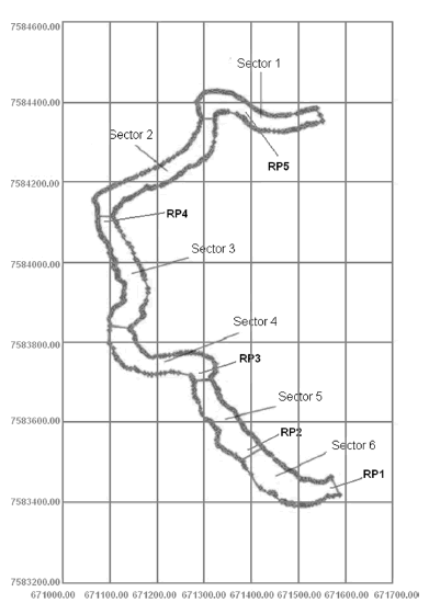
Figure 5. Six sectors of the studied area and position of five sampling points.
Table 7. Straight segments that define the boundaries of the sections.
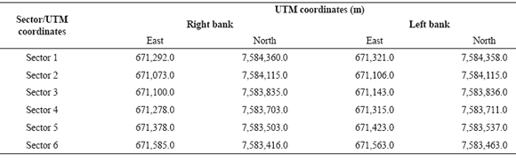
Figure 6 shows, graphically, the average depths calculated over the reservoir on June 1st and 18th. It is possible to see that the average depths along the reservoir after the bottom discharge are always higher than those ones prior to the discharge, meaning an increased deepening of the surveyed section of the river. Figure 7 shows the changes in the depth caused by the discharge along the river course.
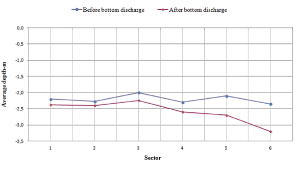
Figure 6. Average depth in each sector before and after the bottom discharge.
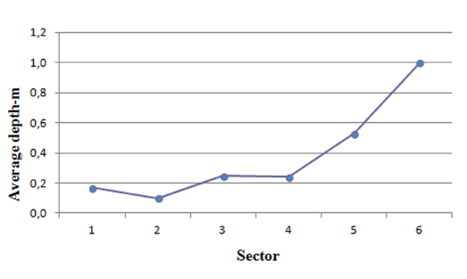
Figure 7. Increment in the depth in each studied sector after the bottom discharge.
Based on the data of the useful volume of the surveyed stretch of the river by sector, the increase in the volume after the bottom discharge was calculated. The values are shown in Table 8 along with other data from the samples collected in the studied area. Due to the absence of information related to the percentage of muddy sediments and of the dry specific weight of the section 2, the average values of sectors 1 and 3 were used.
Table 8. Weight of the muddy sediments and sand dumped downstream the dam after the bottom discharge.
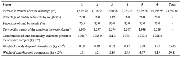
It can be seen from Table 8 that approximately 25 thousand tons of muddy material and sand were dumped downstream of the dam during the discharge, of which 6,400 tons are of muddy sediments.
Conclusions
Based on the sediment sampling, its grain size and chemical analyses, and also on the bathymetrical surveys performed before and after the bottom discharge the following results were found:
1) The bottom discharge increased the volume of the river section between the dam and a bridge 1.6 km upstream in an amount of 24,400 m3. This value can be considered as the sedimentation rate of the dam in a six month period. It was estimated that 6.4 tons of muddy sediment and 20.8 tons of sand were carried downstream the dam due to the bottom discharge.
2) The sedimentation rate of the Paciência dam is not very high, however it is necessary to observe that it is a small hydro power plant and no lake was built for its operation. Previous studies done in Brazil for bigger dams showed higher sedimentation rates, like those ones found in Cachoeira Dourada, Funil, Juturnaíba and Pampulha.
3) The level of muddy sediment (smaller than 0.063 mm) fell drastically after the bottom discharge, especially in the samples collected upstream the Paciência SHP, showing that the bottom discharge is the mainly process that carries the muddy sediments.
4) The comparison of the analyzed samples with the CONAMA Resolution 344/2004, showed that the bottom sediments collected upstream and downstream the SHP presented for heavy metals,
in several samples, values higher than Level 2 (threshold above which a probable adverse effect on the biota is expected) for the elements Cd (cadmium) Cr (chromium) and zinc (Zn), in order of importance. Considering the Level 1 (threshold below which a low probability of adverse effects to biota is expected), the vast majority of the samples were greater than these values. Only in relation to As (Arsenic) all samples show levels smaller than Level 1. In relation to total organic carbon, total volatile solids, total phosphorus and total Kjeldahl nitrogen, it was found that in few samples, the values are bigger than the reference values.
5) The levels of organochlorine pesticides and polycyclic aromatic hydrocarbons have values always below the Level 2 of the CONAMA Resolution 344/2004. A few samples showed values slightly higher than the Level 1 for Acenaphthylene and only one sample has a higher level than Level 1 for Dibenz [a, h] anthracene. Another sample has a higher level than CONAMA threshold for Acenaphthene.
References
1. Bandeira, J.V., 2004. Desenvolvimento de técnicas nucleares e correlatas para estudos em Hidrologia Urbana - Aplicações na Bacia Hidrográfica da Pampulha e no Rio das Velhas, MG. Doctorate Thesis in Sanitation, Environment and Hydro Resources. Engineering School of the Federal University of Minas Gerais. Belo Horizonte, MG, Brazil. [ Links ]
2. Bandeira, J.V., L.H. Salim and M.V. Junqueira, 2011a. Technical Report number 3 - Batimetria e coleta de amostras de sedimentos. Project GT 198 CEMIG/CDTN/CETEC: Environmental evaluation of the Paraibuna River. Belo Horizonte, Brazil. [ Links ]
3. Bandeira, J.V., L.H. Salim and M.V. Junqueira, 2011b. Technical Report number 4 - Análises sedimentológicas e biológicas. Project GT 198 CEMIG/CDTN/CETEC: Environmental evaluation of the Paraibuna River. Belo Horizonte, Brazil.
4. Bandeira, J.V., L.H. Salim and M.V. Junqueira, 2011c. Technical Report number 5 - Levantamentos batimétricos e análises biológicas bentônicas e físico-químicas da água. Project GT 198 CEMIG/CDTN/CETEC: Environmental evaluation of the Paraibuna River. Belo Horizonte, Brazil.
5. Cabral, J.B.P., L.A. Fernandes, I. Scopel, V.A. Becegato and A.P. Fiori, 2009. Evaluation of Sedimentation State in Cachoeira Dourada Reservoir (GO/MG), Brazil. Sociedade & Natureza 21:97-119.
6. Carvalho, N.O., 1994. Hidrossedimentologia Prática. CPRM Books. Rio de Janeiro, Brazil. 372 p. [ Links ]
7. Chanson, H. and P.D. James, 2006. Learning from experience? International Water Power and Dam Construction Magazine. Available at http://espace.library.uq.edu.au/eserv/UQ:8519/ iwpdc06.pdf.
8. CONAMA - Environmental National Council, Ministry of Environment (Brazil), 2004. Resolution number 344, 03/25/2004. Available at http://www.mma.gov.br/port/conama/ legiabre.cfm?codlegi=445.
9. Dauble, D.D., R.L. Johnson and A.P. Garcia, 1999. Fall Chinook Salmon Spawning in the Tailraces of Lower Snake River Hydroelectric Projects. Transactions of the American Fisheries Society 128:672-679.
10. Ferreira, V.V.M., 2004. Avaliação de Externalidades do Setor Hidrelétrico no Estado de Minas Gerais. Doctorate Thesis in Sanitation, Environment and Hydro Resources. Engineering School of the Federal University of Minas Gerais. Belo Horizonte, MG, Brazil.
11. Ferreira, V.V.M., O.E.A. Branco and P.M. Fleming, 2007. Avaliação de Externalidades Agropecuárias na Usina Hidrelétrica de Aimorés. XXIX Congresso Brasileiro de Engenharia Sanitária e Ambiental. Belo Horizonte - MG, Brazil.
12. Forstner, U. and J. Schoer, 1984. Some typical examples of the importance of the role of sediments in the propagation and accumulation of pollutants. In IAEA TECDOC 302 - Sediments and pollution in waterways: general considerations. Research co-ordination meeting on the role of the accumulation and transport of radionuclides in waterways. Vienna, Austria. Available at http://www-pub.iaea.org/MTCD/Publications/ PDF/te_302_web.pdf
13. HHS - United States Department of Health and Human Services, 1995. Toxicological profile for Polycyclic Aromatic Hydrocarbons. Agency for Toxic Substances and Disease Registry - Public Health Service.
14. Ibanez, C., N. Prat, and A. Canicio, 1998. Changes in the hydrology and sediment transport produced by large dams on the lower Ebro River and its estuary. Regulated Rivers: Research & Management 12:51-62. [ Links ]
15. LePreste, P.G., 1989. The World Bank and the Environmental Challenge. London Associated University Press. 263 p.
16. Minardi, P.S.P. 1984. Experiências de carga na cisterna da draga "Boa Vista I", utilizando técnicas nucleares - Technical Report CDTN/NUCLEBRÁS - DERL. PD-021/84.
17. Pinto, B.C.T., F.G. Araújo, V.D. Rodrigues and R.M. Hughes, 2009. Local and ecoregion effects on fish assemblage structure in tributaries of the Rio Paraíba do Sul, Brazil. Freshwater Biology 54:2600-2615. [ Links ]
18. Reddy, D.N., 2002. Recent Water Management Strategies. Water: will there be enough for all? Site available at http://www.indiatogether.org/environment/water/cre-water3.htm.
19. Reinhold, J.O., A.J. Hendriks, L.K. Slager and M. Ohm, 1999. Transfer of Microcontaminants from Sediment to Chironomids, and the Risk for the Pond Bat Myotis Dasycneme (Chiroptera) Preying on them. Aquatic Ecology 33:363-376.
20. Ribeiro, C.B.M., 2007. Sistema de alerta ambiental fundamentado em estudo teórico experimental de transporte e dispersão de poluentes solúveis em cursos de água. Doctorate Thesis in Agricultural Engineering. Federal University of Viçosa, Minas Gerais, Brazil.
21. Sear, D.A., 1995. Morphological and sedimentological changes in a gravel-bed river following 12 years of flow regulation for hydropower. Regulated Rivers: Research & Management 10:247-264.
22. SERLA - Fundação Superintendência Estadual de Rios e Lagos do Governo do Estado do Rio de Janeiro. 1997. Technical Report - Diagnóstico preliminar das condições hidrossedimentológicas do Rio Paraíba do Sul e de seus principais afluentes. Projeto BRA/96/017 - MPO/SEPURB/PQA-ABC-PNUD-UFRJ. Available at http://www.hidro.ufrj.br/pqarj/paginas/36/..%5C..%5Cr elatorios%5Cps-re-29.pdf. Rio de Janeiro, Brazil.
23. Shalash, S., 1998. Effects of sedimentation on the storage capacity of the High Aswan Dam reservoir. Hydrobiologia 91-92:623- 639.
24. Soares, J.H.P., A.C.J. Ribeiro and H.A.S. Guedes, 2010. Avaliação da Capacidade de Transporte e Dispersão do Rio Paraibuna Utilizando Traçadores Fluorescentes. Trecho: Distrito Industrial a UHE Marmelos - Juiz de Fora/MG. Revista Brasileira de Recursos Hídricos 15:45-56.
25. Tortadaja, C., A.K. Biswas and D. Altinbilek, 2012. Impacts of Large Dams; a Global Assessment. Springer Berlin Heidelberg. 405 p.
26. Tucci, C.E.M. (org.), 1993. Hidrologia: Ciência e Aplicação. Coleção ABRH de Recursos Hídricos, volume 4. Editora da Universidade Federal do Rio Grande do Sul / Editora da Universidade de São Paulo / Associação Brasileira de Recursos Hídricos, 914 p.
27. Vilhena, R.M., H.L. Roig and P.R. Meneses, 2003. Determinação do assoreamento de reservatório utilizando técnicas de geoprocessamento, o caso do reservatório de Funil - RJ. XI Simpósio Brasileiro de Sensoriamento Remoto (SBSR). Belo Horizonte - MG.
28. Wasserman, J.C., S.R.S. Barros and C.M. Volcker, 2008. Technical Report - Viabilidade de utilização dos recursos hídricos da Bacia do Rio São João para o Complexo Petroquímico do Rio de Janeiro. Fluminense Federal University. Niterói, RJ, Brazil.

