


Servicios Personalizados
Revista

Articulo
 Inglés (pdf)
 Articulo en XML
 Referencias del artículo
 Enviar articulo por email
Indicadores
-
 Citado por SciELO
Links relacionados
-
 Similares en
SciELO
Similares en
SciELO
Compartir

 Permalink
Latin American journal of sedimentology and basin analysis
versión On-line ISSN 1851-4979
Lat. Am. j. sedimentol. basin anal. vol.21 no.1 La Plata jun. 2014
TRABAJOS DE INVESTIGACIÓN
Seismic sequence stratigraphy of a foreland unit inthe Magallanes-Austral Basin, Dorado Riquelme Block, Chile: Implications for deep-marine reservoirs
Rocío E. Gallardo 1
Departamento de Ciencias de la Tierra, Facultad de Ciencias Químicas, Universidad de Concepción, Víctor Lamas 1290, Concepción, Chile.
(1) Present address: Instituto de Estudios Andinos-CONICET, Departamentode Ciencias Geológicas, Universidad de Buenos Aires, Argentina. rocio.gallardo.jara@gmail.com
Received March 14, 2014
Accepted March 16, 2015
Abstract
This contribution presents geological data that provides a sequence-stratigraphic-based exploration model for Oligocene units in the central Magallanes-Austral Foreland Basin, and identifies the related sedimentary deposits that constitute basin-floor fan reservoirs. The study area is located in the Magallanes Region, Chile, and it was discovered in 2009-2010 by the joint venture of the National Oil Company of Chile and Methanex group at Dorado Riquelme Block. Seismic stratigraphic analysis of the Magallanes-Austral Foreland Basin enabled the definition of four evolutionary stages using 3D seismic information from a 91.6 km long section, as well as lithostratigraphic and biostratigraphic records and wireline logs. The clinoforms observed in the Foreland III stage of the Magallanes-Austral Foreland Basin are the focus of this study. Six seismic units (SU-1 to SU-6) and twenty-five depositional sequences were identified there, based on temporal affinity and genetic mechanisms. The youngest four seismic units comprise alternating forestepping and downstepping prograding patterns, while the fifth seismic unit is characterized by a backstepping pattern, which is followed by a sixth seismic unit in which forestepping patterns are again developed. The most important reservoirs were identified in seismic unit SU-2, and they are associated with sandstone-prone deposits accumulated in basin-floor fans. Their development is associated in this contribution with periods of relative sea-level fall during forced regressions.
Keywords: Sequence stratigraphy; Tropilla basin-floor fan; Foreland III succession; Magallanes-Austral Foreland Basin; Dorado Riquelme exploration block.
INTRODUCTION
A re-new phase of gas exploration was initiated by the joint venture Empresa Nacional del Petróleo (hereafter ENAP) and Methanex in the Magallanes-Austral Foreland Basin in 2004, including the acquisition of 1800 km2 of 3D seismic and the drilling of 66 wells. The basin fill in the area was thoroughly revised under a sequence-stratigraphic approach, identifying main evolutionary stages of the basin (syn-rift, post-rift, transitional, and foreland) and the most important unconformities. Within the foreland stage, four different phases (I-IV) were identified (Mpodozis et al., 2011). Subsequently, new subsurface data was collected in the northern Strait of Magellan edge, the so-called Dorado Riquelme Block (hereafter DRB). Well Tropilla-1 proved gas reserves in the Oligocene basin-floor fan in the North of Gregorio area, termed Tropilla Reservoir, which drew the attention to carry a detailed analysis on the deep-marine reservoirs in the area. This contribution describes and discusses seismic patterns of the Foreland Phase III and their sequence-stratigraphic implications.
The Foreland III succession consists of a large asymmetric wedge of sediments thinning eastwards, with strata occurring both in outcrops and subsurface. This succession lies over a mudstone-condensed section with subparallel clinoform configurations and continuous reflectors. On its westernmost edge, this wedge outcrops as the Loreto Group (Keidel and Hemmer, 1931), and Bahía Inútil Formation (Cañon, 1968). Towards the eastern edge, this succession is present in the subsurface as the Areniscas Arcillosas, and in outcrops as Brush Lake Formation (Barwick, 1955). In the DRB, it reaches up to 1500 m in thickness and becomes progressively thinner eastward in Vellón-Kimiri Aike, where it does not exceed more than 900 m.
A number of studies have tried to explain the stratigraphic relationship and paleogeographic implications of these units (Martínez, 1957; Martínez et al., 1964; Cañon, 1968; Natland et al., 1974; Cañon and Ernst, 1975; Malumián and Caramés, 1977; Malumián, 2002; among others). However, poor outcrop continuity, as well as marked variations in facies and depositional environments have hindered any attempt to understand the regional stratigraphy in a more precise and integral manner.
The main aim of this contribution is, firstly, to document the seismic patterns and sediments comprising the Foreland III wedge, integrating high-quality 3D seismic and wireline logs. In order to do so, seismic geometries and stratal terminations within the unit are first presented and discussed. Subsequently, the potential relationships between observed seismic stacking patterns, accommodation, sediment supply, and resulting sand-prone deep-water reservoirs are discussed.
GEOLOGIC SETTING
The Magallanes-Austral Basin is situated in the southernmost part of South America, between 47° and 55° S latitude, southward from the Chile Triple Junction (Fig. 1). The basin covers about 200.000 km2 and has an elongated geometry oriented NNW-SSE. It reaches a maximum width of 370 km and a length of 700 km (Biddle et al., 1986; Wilson, 1991). To the south and west the area is limited by the Patagonian Andes, and towards the east the Río Chico-Dungeness High represents an elevated portion of the metamorphic basement that separates it from the Malvinas Basin (Fig. 1).
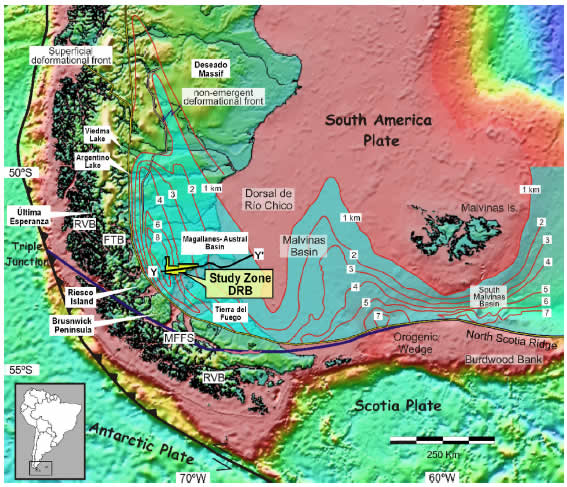
Figure 1. Map of the Magallanes-Austral Foreland Basin with main morpho-structural elements and adjacent basins (modified after Ghiglione et al., 2009). The study area, the Dorado Riquelme Block (DRB), is also shown (yellow square). The Magallanes-Austral Basin structure contours indicate foreland sediment thickness (in kilometers) within the undeformed depocenters. FTB: fold thrust belt; RVB: Rocas Verdes Marginal Basin; MFFS: Magallanes-Fagnano Fault System. Y-Y' represents the regional west-to-east seismic line shown in the Figure 2.
Currently, the foredeep is developing towards the east and the north of the orogenic front, and is not affected significantly by the compressive tectonic processes. The geologic evolution of the Magallanes-Austral Basin followed in this contribution is mostly based on the work of Mpodozis et al. (2011). In terms of geodynamic evolution, the Magallanes-Austral Basin can be divided into four main tectonic stages: syn-rift, sag/post-rift, transitional, and foreland stages (Figs. 2, 3).

Figure 2. a) General seismic configuration of the Magallanes-Austral Basin near the Magallanes strait (inset map with seismic line transect, Y-Y'; modified after Mella et al., 2010). This regional seismic line and the interpreted line shown in b) clearly illustrate the onlap configuration of the early Foreland Stage strata onto previous deposits. Units Foreland I and II are interpreted to represent foredeep sediments, following the sketch presented in c), which has been adapted from Horton and DeCelles (1997). TWT: reflection transit time in seconds (the same for figures 3, 4, 5, 8, and 9). Foreland III stage is the focus of this contribution.

Figure 3. a) Seismic line of the study area (X-X'), highlighting the main evolutionary stages of the Magallanes-Austral Basin from the syn-rift state to the foreland stage. b) Map with the location of the seismic-line transect shown in a) and the topographic map of the Dorado Riquelme Block. In this topographic map, black circles represent drilled wells used in this contribution. 1: Manzano 1; 2: Manzano GMC-2; 3: Cruceros 2; 4: Punta del Cerro 5; 5: Punta del Cerro 2; 6: Punta del Cerro 4; 7: Tropilla 1; 8: Tropilla 3; 9: Matungo D; 10: Vellón 1. Figures a) and b) modified after Mella et al. (2010).
Syn-rift Stage. This stage is related to the initial extensional breakup of Gondwana, which affected the whole Austral Patagonia (Gust et al., 1985; Pankhurst et al., 2000). Extensional tectonics produced NNW-SSE-oriented grabens and hemigrabens onto a pre-existing Paleozoic metamorphic basement, which were lately filled mostly with volcanic and volcaniclastic rocks (Moraga, 1996). Syn-rift successions, mostly middle Jurassic in age, are known as Ibañez, Tobífera, and Complejo El Quemado (Uliana et al., 1986; Hanson and Wilson 1991; Féraud et al., 1999; Pankhurst et al., 2000). As a result of this extensive phase, the continental crust broke and the sea-floor emerged along the western margin of the Patagonian Andes, the so-called Rocas Verdes Basin (Katz, 1963; Stern, 1980; Biddle et al., 1986).
Sag/Post-rift Stage. After the rifting stage, the basin evolved into a sag stage characterized by thermal subsidence. The stratigraphic record represents a long-term retrogradational event (Fig. 3) that spans from the latest Jurassic to early Cretaceous (Biddle et al., 1986; Robbiano et al., 1996), which continued to extend eastward and northward into the Magallanes Basin (Mpodozis et al., 2006). In this initial stage, the Springhill Formation was deposited. These transgressive deposits are characterized by quartz arenites with bipyramidal quartz clasts (Varela et al., 2012). This unit grades laterally and vertically into a thick deep-marine succession represented mostly by mudstones, and known as Zapata, Erezcano, Estratos con Favrella and Río Mayer Inferior formations (Biddle et al., 1986; Macellari, 1988; Wilson, 1991; Varela et al., 2012).
Transitional Stage. During Aptian to Albian times, a transition to a foreland tectonic regime took place. This transitional stage correlates with a time of a quick oceanic expansion of the Atlantic Ocean and the Wedell Sea, and occured simultaneously with an increase in the convergence speed between the Pacific and the South American Plates (Dalziel, 1986; Ramos, 1988). Additionally, this stage is also characterized by the beginning of the subduction process towards the west of the inner edge of the Rocas Verdes Basin, ultimately closing during the Turonian (Fildani et al., 2003; McAtamney et al., 2011; Mpodozis et al., 2011). Evidence of this process is documented towards the south of the Beagle Channel (Hardy and Yaghan formations: Dott et al., 1977; Suárez, 1979; Suárez et al., 1985), and in the Magallanes area (Canal Bertrand Formation: Castelli et al., 1992; Mella, 2001). A subduction system developed throughout the west margin of South America, generating a magmatic arc called Southern Patagonian Batholith, which is composed of plutons with calk-alcaline affinity and whose magmatic activity can be observed since the early Cretaceous toward the west of Rocas Verdes Basin (Stern and Stroup, 1982; Bruce et al., 1991), with its maximum activity between 110 and 90 My (Hervé, 2005).
Foreland Stage. The paleogeography of southern South America changed drastically during the late Cretaceous, starting with the production of tectonic pressure and cortex flexure, caused by the Austral Andean tectonic rise and the tectonic stacking from derived material of the Rocas Verdes Basin and the western Magallanes shelf margin on the continental edge (Biddle et al., 1986; Dott et al., 1977; Wilson, 1991; Mpodozis et al., 2011). Data integration from surface and subsurface allowed for the establishment of four successively developing phases in the Foreland Basin, whose orogenic deformation front migrated eastward and northward (Moraga et al., 2004; Mella et al., 2007; Mpodozis et al., 2011). These phases are called Foreland I, II, III, and IV in this contribution and are summarized briefly below in order to place in context, the stratigraphic record of Foreland III, the focus of this study (Figs. 2, 3).
Foreland I (Coniacian - Maastrichtian). It forms a wedge that thickens westwards (Figs. 2, 3). This unit represents a long-term progradational event, with development of slope fans and basin-floor fans migrating from the north-northwest (Punta Barrosa and Cerro Toro formations: Katz, 1963; Cortés, 1964; Winn and Dott, 1979; Wilson, 1991; Fildani et al., 2003), culminating with deltaic systems coming from the north and west during Campanian-Maastrichtian times (Tres Pasos, Latorre, Fuentes, La Anita, Cerro Fortaleza, Chorrillo and Mata Amarilla formations: Katz, 1963; Charrier and Lahsen, 1969; Macellari, 1988; Covacevich, 1991; Wilson, 1991; Fildani et al., 2003; Shultz and Hubbard 2005; Varela et al., 2012). Toward the east, in the Atlantic margin, contemporaneous facies are deposited in offshore settings (Arroyo Alfa and Cabeza de León formations: Robbiano et al., 1996).
The first deposits in this phase have been dated in the Punta Barrosa Formation from Última Esperanza Province, and the age was estimated in 90±1 My (Fildani et al., 2003). Then, Fosdick et al. (2011) obtained new zircon U-Pb ages from an interbedded volcanic ash in the Zapata-Punta Barrosa transition, suggesting an age of 101±1 My. Recently, Varela et al., (2012) using the U-Pb method dated detrital zircons from Mata Amarilla Formation from the Santa Cruz Province, yielding an age of 96±0.71 My.
Foreland II (Paleocene - Eocene). Its base lies over an erosive unconformity that becomes non-depositional towards the east (“onlap” surface) and therefore the unit thins in that direction (Figs. 2, 3). The progressive Foreland Basin migration to the craton also triggered a simultaneous eastward shifting of the Tertiary basin, recorded in an extensive transgression (Glauconitic Zone Formation: Hauser, 1964; Natland et al., 1974), creating a depocenter in the Manzano area (Fig. 3) (Natland et al., 1974; Mella, 2001; Moraga et al., 2004). The foredeep deposits consist of a thick, transgressive, deep-marine to shallow-marine section (Chorrillo Chico, Agua Fresca and Tres Brazos formations: Thomas, 1949; Todd and Kniker, 1952; Cañon and Ernst 1975), whose sediments extend as far as Tierra del Fuego, where the southern margin is supplied with clastics from the raised and eroded Fuegian Andes foothill (Ballena Formation: Ghiglione et al., 2002; Rojas and Mpodozis, 2006).
Foreland III (late Eocene - early Miocene). This stratigraphic interval, which is the focus of this study, consists of an asymmetric sedimentary wedge, widely distributed across the area. Since middle Eocene a reactivation by flexure took place in the basin, causing it to become deeper as well as changing the polarity of the sedimentation pattern, with an offlap break migration from the north and the southeast (Castro, 1977; Mella, 2001; Malumián, 2002; Carpinelli and Mella 2006; this work). As the tectonic load from the south has decreased for this time, the north-south thickness variation is less significant at this phase than in the previous ones. In the Manzano area it is up to 1500 m thick, becoming gradually thinner towards the north, west and east (Figs. 2, 3). The stratigraphic package of Foreland III is characterized by the development of clearly imaged high-angle seismic reflectors, here shortly called clinoforms. It is interpreted that these features suggest terrigenous contribution from the west and west-southwest, coeval with the orogenic raise produced by an increase in the convergence rate of the oceanic trench portion located westward of the basin (Mpodozis et al., 2011). This wedge comprises several major prograding complexes (Leña Dura, Loreto, Areniscas Arcillosas, Bahía Inútil Group, Magallanes and Margosa Superior formations: Decat and Pomeyrol, 1931; Keidel and Hemmer, 1931; Cañon, 1968; Robbiano et al., 1996; Mella, 2001), which are described in detailed in this contribution.
Foreland IV (early Miocene - Holocene). During the Miocene the sedimentation occurred over an area with minimum regional slopes, due to little or non-existent flexural subsidence in the Dorado Riquelme Block (Mella, 2001). The resulting strata show an internal seismic pattern consisting of concordant reflectors without evident high-angle features (Figs. 2, 3).
During this time extensive transgressions from the Atlantic (Brush Lake Formation: Barwick, 1955) evolved contemporaneously with fluvial systems (El Salto Formation: González, 1952; Filaret Formation: González, 1965), with a predominant continental sedimentation at the top of the sequence. This fluvial succession passes laterally into volcanic deposits (Palomares Formation: Keidel and Hemmer, 1931; González, 1965). In addition, towards the southeast, in the Atlantic margin of Tierra del Fuego, it is possible to recognize progradation of strata associated with the last stage of the thrust system in the Fueginian Andes (Puesto San José and Malengueña formations: Torres Carbonell et al., 2009).
METHODOLOGY AND DATABASE
The seismic stratigraphic analysis of the succession comprising the Foreland III phase was carried out using a three dimensional (3D) seismic volume of 1800 km2 acquired by the joint venture ENAP-Methanex. The 3D transect selected for this study has a WSW-ENE orientation, perpendicular to the observed high-angle reflectors (Fig. 4). This seismic section is 91.6 km long and it was calibrated with information obtained from ten wireline logs, adjusted in time and depth by Checkshots (transit time records), between the Manzano area in the west and the Kimiri Aike in the east (Fig. 4).

Figure 4. Uninterpreted (a) and interpreted (b) seismic line of Foreland III phase in the study area. Location of wells is also indicated. b) Interpreted seismic line showing all the reflectors mapped for this study and key stratigraphic surfaces. Clinoform configurations are observed in lower and middle parts of the seismic line, and they are interpreted to reflect shelf edge-slope-basin depositional systems. Parallel to subparallel high-amplitude reflectors, which are dominant in the upper part of Foreland III, are interpreted to reflect shallow-marine (shelf) settings. Inset shows the location of the seismic-line transect (A-A').
The quality of the seismic information enables the observation of the acoustic contrast in the rock bodies because it has a good lateral continuity and low noise to signal ratio. In general, it is possible to observe cogent correspondence between the seismic events and the recorded information from wells. Additionally, the structural deformation did not result in major difficulties for data interpretation. Due to its location east of the orogenic front, compressive events have barely affected the area of study.
Within the presented seismic section, three main regions can be differentiated from west to east: Manzano-Cruceros, Punta del Cerro-Tropilla and Matungo-Vellón (Fig. 4). For the description and understanding of the Foreland III succession this study integrated 3D seismic information with geophysical well-log responses (density and resistivity curves) of Manzano 1, Manzano GMC 2, Cruceros 1, Punta del Cerro 5, Punta del Cerro 2, Punta del Cerro 4, Tropilla 1, Tropilla 3, Matungo D and Vellón 1 wells (Fig. 4). Additionally, it included chronostratigraphic data (Punta del Cerro 1 well) and biostratigraphy (Palenque 1 well).
Key surfaces were identified by means of stratal terminations, distinguishing onlap, downlap, toplap surfaces and erosional truncations (Mitchum, 1977). The methodology consisted in defining and identifying reflectors, which are assumed to represent contacts between strata and timelines. Once these reflectors were identified using a high-quality seismic vertical resolution, a random zero level was established with base of sequence 1, time 1, where 159 different reflections with their respective terminations were defined. Some of these reflections were interpreted as Type I or Type II sequence boundaries (Posamentier and Vail, 1988). Subsequently, it was possible to identify different seismic patterns that helped to subdivide the Foreland III succession into several depositional sequences of different magnitude and scale. Six seismic units were identified, labeled from the oldest to the youngest as SU-1 to SU-6 (Fig. 5).

Figure 5. a) Uninterpreted seismic line of figure 4 with black and white amplitude and wireline data for selected wells (green and black curves). Yellow triangle indicates approximated dip. b) Interpreted seismic line showing the six seismic units identified in this contribution (SU-1 to SU-6). They were differentiated based on clinoform configuration, internal patterns and their boundaries. Three main seismic patters were identified: forestepping, downstepping and backstepping. SU: seismic units. Approximate location of absolute ages discussed in the text is also indicated.
SEISMIC SEQUENCE-STRATIGRAPHIC ANALYSIS OF THE FORELAND III SUCCESSION
Description of Seismic Units (SU)
The overall regression associated with the Foreland III succession is characterized by packages of clinoforms prograding basinward, with shelf-margin gradient between 2° to 5° towards the ENE (Fig. 5). Six seismic units were identified in this study, which are differentiated by their seismic facies and clinoform profile. Clinoforms characterized by forestepping, downstepping and backstepping were recorded. These seismic units are described below from oldest to youngest.
Seismic Unit SU-1. The thickest succession of this unit was deposited in the western side of the study area, reaching 650 m in thickness (Manzano-Cruceros area). In the eastern side the minimum thickness recorded was 35 m (Matungo-Vellón area) (Fig. 5). Based on the seismic pattern of clinoforms, this unit is characterized by a forestepping stacking, with internal configurations ranging from sigmoid to oblique, clearly reflecting the original depositional slope which was characterized by a marked progradational trend (Figs. 5, 6a). The slope gradient varies between 2 and 5° (Fig. 5). In the Manzano-Cruceros area the parallel, low-angle reflectors suggests shelfal conditions. Wells show coarsening-upward packages from mudstone and muddy sandstone at the base, grading vertically to medium and coarse-grained calcareous sandstones. Collectively, this shelfal succession represents the bottom section of the Loreto Formation. In addition, in the transition from Cruceros to Punta del Cerro regions, it is possible to recognize successions of deep-marine sediments associated with slope and basin-floor fan depositional environments (Fig. 7). The minimum age assigned to the top of this unit, based on biostratigraphic studies of marine microfossils (Gema, 2007), is late Eocene to early Oligocene.
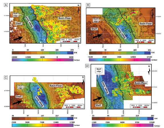
Figure 6. Isopach (grid) and amplitude anomalies (contour) maps for selected intervals within the Foreland III succession (modified after DRB exploration team by ENAP). a) Seismic Unit SU-1; b) and c) Seismic Unit SU-2; d) Seismic Unit SU-3. These maps help to pinpoint the offlap break and therefore the approximate boundaries between shelf, slope and basin-floor domains. The WSW to ENE migration of systems prevails over time. These maps also illustrate the potential sand-prone bodies associated with basin-floor and shelf-edge settings.
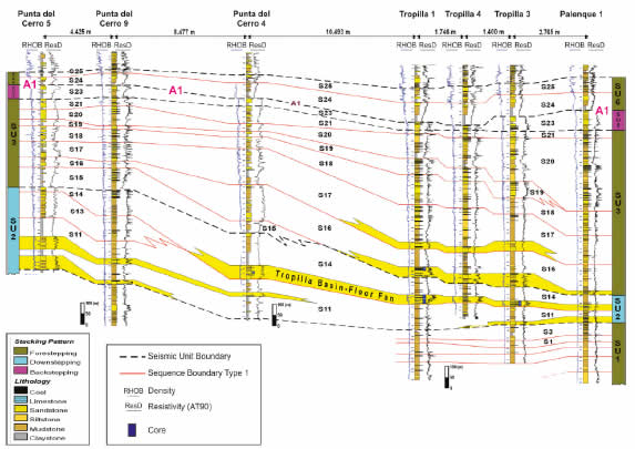
Figure 7. Correlation panel from wells between Punta del Cerro and Palenque area. The correlation, guided by mapped seismic surfaces (allostratigraphic correlation), includes high-order sequences recognized within seismic units SU-2 to SU-6 (see text for discussion). Note the deep-water sandstone reservoirs associated with SU-2 (Tropilla reservoir and others). For well location see figures 3b and 5.
Seismic Unit SU-2. This sequence shows the greatest thicknesses in the central area of DRB, reaching up to 540 m thick in Punta del Cerro. It thins westwards (35 m in the Manzano-Cruceros area) and eastwards (140 m in Tropilla area) (Fig. 5). It is composed of a series of prograding sequences, with their deposits confined between the slopes and very little vertical and lateral development towards internal positions of the basins. Toplap terminations can be recognized on every sequence, typical of progradation, while over the lower slope and basin-floor a series of sandy units associated with a deep-marine deposition can be observed (Fig. 5). This seismic unit is characterized by a trend of clinoforms with oblique patterns dipping eastward (Fig. 6b,c). The slope gradient reaches its maximum (5°) between Punta del Cerro 5 and 2 wells (Fig. 5). In the Punta del Cerro-Tropilla area, this SU-2 lithostratigraphically represents the middle part of Bahía Inútil Formation attached to the slopes. This unit displays a coarsening-upward section, comprising fossiliferous mudstones, siltstones and glauconitic sandstones, with interbedded calcareous levels (Fig. 7). The interpreted depositional environment is mainly deep-marine, associated with slope and basin-floor fans complexes. The maximum depositional age for this unit, based on a biostratigraphic study of a nannofossil assemblage (Gema, 2007) is late Eocene to early Oligocene. In addition, Hervé (2005), using the U/Pb method, dated detrital zircons from Punta del Cerro 1 well, at 1418 mbsl (meters below sea level), yielding an age of 28.5-29.2 My. This is the minimum depositional age at the top of this sequence.
Seismic Unit SU-3. This sequence reaches a thickness of 310 m in the Manzano area and 240 m in Cruceros, thickening eastward up to 550 m in the Punta del Cerro-Tropilla area (Fig. 5). It is the thickest seismic unit in the whole transect. The typical seismic pattern of SU-3 is forestepping, characterized by an eastward shift on the shelf edge. Clinoform configuration shows a sigmoid to oblique pattern with discontinuous reflectors towards the basin (Fig. 6d). The thickest sections are located in areas close to basin-floor settings, and the slope gradient varies between 3° and 5° (Fig. 5).
In the western sector (Manzano-Cruceros area) this unit is composed of fine- to coarse-grained sandstones and mudstones, which lithostratigraphically correspond to the upper part of the Loreto Formation. Shallow-marine conditions (shelfal setting) are inferred in this area where reflectors are mostly parallel (Fig. 5). On the other hand, in the Punta de Cerro-Tropilla area, fine-grained deposits prevailed, with minor proportion of limestones and glauconitc sandstones. These strata are known as Bahia Inútil and Areniscas Arcillosas formations and are inferred to reflect deposition in deep-marine settings.
Hervé (2005) dated detrital zircons by means of the U/Pb method taken from Punta del Cerro 1 at 1.254, 862 and 807 mbsl. They were 27.6-31.3, 28.2-30.9 and 27.5-28.7 My. respectively, limiting thus SU-3 between 28.5-29.2 and 27.5-28.7 My (late Oligocene).
Seismic Unit SU-4. This sequence has little expression in the Dorado Riquelme Block, being approximately 35 m thick in the Matungo 1 well and 200 m thick in the Vellón 1 well (Fig. 5). Despite its limited vertical and lateral extension in the study area, the seismic pattern in the Matungo-Vellón area clearly suggests a downstepping configuration (Fig. 5). The measured slope gradient is about 5° and the entire succession correlates eastward with the upper part of Brush Lake Formation.
Seismic Unit SU-5. It is well represented across the study area, having a slight eastward thickening, from 35 m in the Manzano-Cruceros area to 80 m in the Matungo-Vellón area. The characteristic seismic pattern in this unit is backstepping, and the internal pattern is dominated by sub-horizontal and subparallel continuous reflectors (Fig. 5). Fine- to medium-grained sandstones with fossil remains, sandy siltstones, and mudstones are recorded in the Punta del Cerro-Tropilla area, whereas towards the east (basinward), basal mudstones grade vertically into muddy sandstones (Fig. 7). All these deposits are interpreted to represent shallow-marine conditions. The top of this sequence corresponds to the A1 electric marker according to ENAP nomenclature (1983), probably late Oligocene in age (Fig. 5).
Seismic Unit SU-6. This unit is solely distributed over the central and eastern sectors of the study area and shows an eastward thickening from 70 m in Punta del Cerro to 140 m in the eastern margin (Fig. 5). SU-6 shows a characteristic forestepping stacking. Clinoforms configurations in this unit are subhorizontal and subparallel pattern with continuous reflectors. The vertical succession in the Punta del Cerro-Tropilla area comprises mostly mudstones and glauconitic sandstones, interbedded with minor conglomerates and carbonaceous mudstones (Fig. 7). This succession, which represents the western portion of the Brush Lake Formation, is considered to represent sediments deposited in shelf settings. The top of this sequence corresponds to the Brush Lake electric marker (ENAP nomenclature, 1983), inferred to be Aquitanian on age (early Miocene) (Fig. 5).
Interpretation of Seismic Units
Based on clinoform configuration three different stacking patterns were identified in the studied seismic interval: forestepping, downstepping and backstepping. These clinoforms are associated with widespread and thick successions at the base of the interval (Fig. 5), with configurations ranging from oblique to sigmoid (SU-1 to SU-4). On the other hand, successions become thinner at the top, with subparallel reflectors covering the entire study area (SU-5 and SU-6).
Forestepping (SU-1, SU-3 and SU-6). This stacking pattern is interpreted to develop during normal regression. In these seismic units accommodation creation in proximal positions of the basin did not overcome sedimentation rate, resulting in stratal aggradation on the shelf as well as progradation basinward. In SU-1 and SU-3 the clinoform trajectory has a relatively low angle, with strong progradation basinward and relatively less aggradation on the shelf, with a total use of the accommodation space. These conditions produced thick successions near the upper slope setting, but dominated by fine-grained sediments (Figs. 5, 7). In other words, coarse-grained sands deposited in deep-water settings were not common. In turn, SU-6 shows a greater aggradational rate in the shelf and a smaller progradation rate towards the basin (Fig. 5).
Downstepping (SU-2 and SU-4). The characteristic configuration for these seismic units is a downstepping pattern, prograding towards the basin with a negative trajectory (progradation > aggradation) (Fig. 5). In this situation the shoreline is forced to move basinward regardless of sediments supply, with high rates of progradation towards the basin and high rates of subaerial erosion in the areas that are exposed after the relative sea-level fall (Catuneanu et al., 2011).
In the SU-2, the regressive clinoforms succeed each other towards the basin, with a continuous decrease in accommodation space. As a result of this, deep-marine depositional systems received a significant volume of coarse sediments that cannot be stored in fluvial and/or shallow-marine settings. Eventually, this causes marine onlap over the slope and downlap on the basin-floor, both of them as result of the relative sea-level fall. Although seismic data is limited for SU-4, it is also possible to recognize a drastic reduction in accommodation and development of a major subaerial, erosional surface across most of the study area (contact between top of SU-3 and base of SU-5 in Fig. 5). Deposition took place in the easternmost part of the study area associated with strong progradation basinward, which most likely continued eastward of the investigated region.
Backstepping (SU-5). The characteristic seismic pattern in this seismic unit is backstepping, due to a regional transgressive event (Fig. 5). Relative sea-level rise produced a significant increment on accommodation, which in turn exceeded the contemporaneous sediment delivered to the basin. This resulted in facies retrogradation, as well as expansion of marine conditions across the entire investigated region.
IMPLICATIONS FOR DEEP-MARINE RESERVOIRS
Although prograding clinoforms are the distinct seismic configurations of the Foreland III succession, deep-marine sandstone bodies, potentially representing good reservoirs, were not common across the investigated succession. However, the downstepping pattern (negative trajectory) represented by SU-2 is associated with well-developed sand-prone bodies on the basin floor (S11 and S14) (Figs. 7-9). These units are seismically characterized by continuous reflectors with high amplitude, which are subparallel to slightly sinusoidal (Figs. 8, 9). Some of these sand-prone units were tested and they were identified as good gas reservoirs. These sandstone reservoirs are located within specific systems tracts of higher-order sequences (Fig. 8). Although the complete description of these higher-frequency sequences is beyond the scope of this study, sequences S11 and S14 (from up to 25 recognized in the Foreland III succession), are described and illustrated in detail, due to their importance as containing the deep-marine reservoirs (Figs. 7-9).

Figure 8. a) Uninterpreted seismic line and wells shown in Figure 4. b) High-order sequences seismically defined in the Foreland III succession. There are twenty five sequences commonly limited by Type I sequence boundary (continuous red line), except sequences 5 and 8, whose base corresponds to a Type II sequence boundary (discontinuous red line). Large yellow triangle indicates approximated dip. S: sequence. characterized by onlap over the upper slope, and its early stage of lowstand systems tract resulted in the development of basin floor-fan deposits, from which Palenque (3.5 km) is the oldest one (Figs. 8, 9a). A slope complex and a lowstand prograding wedge lie over these basin-floor fan deposits.
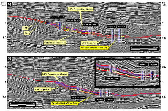
Figure 9. Depositional pattern from sequences S11 and S14. a) Sequence S11; b) Sequence S14. Continuous red line: Type I sequence boundary; in blue, density curve (RHOB); in black, deep resistive curve (AT90); LST: lowstand systems tract; TST: transgressive systems tract; HST: highstand systems tract.
As in the previous case, Sequence S14 overlies a Type I sequence boundary. This sequence reaches up to 110 m thick in the Punta del Cerro-Tropilla area and has a similar configuration with lowstand systems tract having a well-developed basin-floor fan, slope complex and a prograding wedge. This sand-prone reservoir is known as Tropilla 14 and is 19 km long from the lower slope to the basin-floor setting (Figs. 8, 9b). It is characterized by bidirectional downlap onto the sequence boundary and the overlying slope complex produces downlap onto it. In terms of facies, Tropilla 14 is characterized by fine conglomerates, coarse- to fine-grained sandstones, mudstones, and carbonate-rich levels (Fig. 7).
In summary, the most important deep-marine deposits in terms of reservoir characterization (thickness, distribution, facies), were identified in the interpreted lowstand systems tracts of several high-frequency sequences developed within SU-2. Therefore, reservoir formation is related to episodes of relative sea-level fall, within a long-term forced regression, which in turn is linked to periods of strong reduction of accommodation and basinward migration of the shelf break.
CONCLUSIONS
1) High-resolution seismic data together with boreholes and chronostratigraphy allows for the identification of several seismic units with different clinoform configuration and corresponding sediments in the late Eocene-early Miocene Foreland III phase for the Dorado-Riquelme Block (Magallanes-Austral Basin, Chile).
2) Six seismic units (SU-1 to SU-6), characterized by three different seismic patterns were recognized in the Foreland III succession. (a) Forestepping (SU-1, SU-3, SU-6) was produced during normal regression and ascending clinoform trajectory, with stratal progradation basinward and relatively less aggradation on the shelf. (b) Downstepping (SU-2, SU-4) occurred due to relative sea-level fall during forced regression and resulted in laterally accreted sequences, with progradation towards the basin under a negative clinoform trajectory. (c) Backstepping (SU-5) resulted from a strong retrogradation of the marine system, associated with a relative sea-level rise that greatly overcome sediment supply.
3) The migration pattern of the shelf-break follows a WSW-ENE orientation, which reflects the original depositional slopes, marked by a progradational trend at the beginning of the deposition and a relative shallowing at the end of the Foreland III phase.
4) The most significant sand-prone reservoirs in terms of thickness, distribution and facies were developed in basin-floor settings. They are associated with lowstand systems tracts of high-order sequences, within the longer term downstepping seismic pattern (forced regression) that characterizes seismic unit SU-2.
Acknowledgements
The ENAP geologists team for their kind review of this contribution. This study was developed by ENAP (National Oil Company of Chile) and Methanex, that supported the research presented here. The author would like to thank LAJSBA reviewers for the constructive comments (especially to the editor Dr. Ernesto Schwarz), which largely improved this manuscript. Natalia Varela is thanked for her help in the edition of this manuscript. Special thanks go to Universidad of Concepcion in Chile. This is contribution R-155 of the Instituto de Estudios Andinos Don Pablo Groeber (UBA-CONICET).
REFERENCES
1. Barwick, J., 1955. The surface stratigraphy of portions of Magallanes Province, Chile. Informe Archivo Técnico ENAP, Santiago. (inédito). [ Links ]
2. Biddle, K.T., M.A. Uliana, R.M. Mitchum, M.G. Fitzgerald and R.C. Wright, 1986. The Stratigraphic and Structural Evolution of the Central and Eastern Magallanes Basin, Southern South America. In P.A. Allen and P. Homewood (Eds.), Foreland Basins. International Association of Sedimentologists, Special Publication 8:41-61. [ Links ]
3. Bruce, R. M., E.P. Nelson, S.G. Weawer and S. Lux, 1991. Temporal and spatial variations in the Southern Patagonian Batholith; constrains on magmatic arc development. In R.S. Harmon and C.W. Rapela (Eds.), Andean magmatism and its tectonic setting. Geological Society of America, Special Paper 265:1-12. [ Links ]
4. Catuneanu, O., W.E. Galloway, C. Kendall, A.D. Miall, H.W. Posamentier, A. Strasser and M.E. Tucker, 2011. Sequence Stratigraphy: Methodology and Nomenclature. Newsletters on Stratigraphy 44: 173-245 [ Links ]
5. Cañon, A., 1968. Cronoestratigrafía de los sedimentos Terciarios de Tierra del Fuego, Provincia de Magallanes. Memoria de prueba para optar al Título de Geólogo, Facultad de Ciencias Físicas y Matemáticas, Departamento de Geología, Universidad de Chile, 133 pp. (inédito). [ Links ]
6. Cañon, A. and M. Ernst, 1975. Cuadro de correlaciones estratigráficas de la Provincia de Magallanes. Informe Archivo Técnico ENAP, Santiago, 4 pp. (inédito). [ Links ]
7. Carpinelli, A. and P. Mella, 2006. Exploración en Secuencias Oligocenas-Miocenas en los Bloques Riquelme/Manzano-Dorado/Puerto Sara. Informe Archivo Técnico ENAP, Santiago, 102 pp. (inédito). [ Links ]
8. Castelli, J. C., R. Robertson and A. Harambour, 1992. Evaluación Geológica y Petrolera, bloques Ultima Esperanza Sur e Isla Riesco. Informe Técnico ENAP, Santiago. (inédito). [ Links ]
9. Castro, C., 1977. Evaluación sedimentológica del Distrito Carbonífero Mina Rica-Pecket, Península de Brunswick, Magallanes. Memoria de prueba para optar al Título de Geólogo (informe de avance), Universidad de Chile, Facultad de Ciencias Físicas y Matemáticas, Departamento de Geología, Santiago, 31 pp. (inédito). [ Links ]
10. Charrier, R. and A. Lahsen, 1969. Stratigraphy of Late Cretaceous-Early Eocene, Seno Skyring-Strait of Magellan area, Magallanes province, Chile. American Association of Petroleum Geologists Bulletin 53:568-590. [ Links ]
11. Cortés, R., 1964. Estratigrafía y un estudio de paleocorrientes del flysch cretáceo del Departamento de Última Esperanza. Memoria de Título, Universidad Técnica del Estado, Santiago, 117 pp. (inédito). [ Links ]
12. Covacevich, V., 1991. Estudios paleontológicos y biostratigráficos en la costa Norte de Isla Riesco e interior de Seno Skyring, Región de Magallanes. Informe Archivo Técnico ENAP, Santiago, 55 pp. (inédito). [ Links ]
13. Dalziel, I.W.D., 1986. Collision and Cordilleran orogenesis: an Andean perspective. In M.P. Coward and A.C. Ries (Eds.), Collision Tectonics. Geological Society, Special Publication 19:389-404. [ Links ]
14. Decat, J. and R. Pomeyrol, 1931. Informe Geológico sobre las posibilidades petrolíferas de la Región Magallánica (21-VII-1929). Boletín Minero, Sociedad Nacional de Minería, Santiago, año 47, 389:763-772. [ Links ]
15. Dott, R. H., R.D. Winn, M.J. Dewit and R.L. Bruhn, 1977. Tectonic and sedimentary significance of Cretaceous Tekenika beds of Tierra del Fuego. Nature 266:620-622. [ Links ]
16. Empresa Nacional del Petróleo, ENAP., 1983. Seminario Ingeniería del Petróleo, Markers Litológicos y Eléctricos ENAP, Magallanes. Informe Archivo Técnico ENAP, Santiago, 12 pp. (inédito). [ Links ]
17. Féraud, G., V. Alric, M. Fornari, H. Bertrand and M.J. Haller, 1999. 39Ar/40Ar dating of the Jurassic volcanic province of Patagonia: migrating magmatism related to Gondwana break-up and subduction. Earth and Planetary Science Letters 172:83-96. [ Links ]
18. Fildani, A., T.D. Cope, S.A. Graham and J.L. Wooden, 2003. Initiation of the Magallanes foreland basin: Timing of the southernmost Patagonian Andes orogeny revised by detrital zircon provenance analysis. Geology 31:1.081-1.084. [ Links ]
19. Fosdick, J.C., B.W. Romans, A. Fildani, A. Bernhardt, M. Calderón and S.A. Graham, 2011. Kinematic evolution of the Patagonian retroarc fold-and-thrust belt and Magallanes foreland basin, Chile and Argentina, 51º30ʼS. Geological Society of America Bulletin 123:1679-1698 [ Links ]
20. Gema, 2007. Análisis bioestratigráfico pozo Palenque 1. Informe Archivo Técnico ENAP, Santiago, 13 pp. (inédito). [ Links ]
21. Ghiglione, M.C., V.A. Ramos and E.O. Cristallini, 2002. Estructura y estratos de crecimiento en la faja plegada y corrida de los Andes fueguinos. Revista Geológica de Chile 29:17-41. [ Links ]
22. Ghiglione, M.C., F. Suárez, A. Ambrosio, G. Da Poian, E.O. Cristallini, M.F. Pizzio and R.M. Reinoso, 2009. Structure and evolution of the Austral basin fold-thrust belt, southern Patagonian Andes. Revista de la Asociación Geológica Argentina 65:215-226. [ Links ]
23. González, E., 1952. Levantamiento Geológico Estructural en el área de estancia El Salto-Sección Las Coles. Informe Archivo Técnico ENAP, Santiago. (inédito). [ Links ]
24. González, E., 1965. La Cuenca Petrolífera de Magallanes. Revista Minerales, Instituto de Ingenieros de Minas, Santiago 91:1-15. [ Links ]
25. Gust, D.A., K.T. Biddle, D.W. Phelps and M. Uliana, 1985. Associated Middle to Late Jurassic Volcanism and Extension in Southern America. Tectonophysics 116:223-253. [ Links ]
26. Hanson, R.E. and T.J. Wilson, 1991. Submarine Rhyolitic Volcanism in a Jurassic Proto Marginal Basin; Southern Andes, Chile and Argentina. Andean Magmatism and Its Tectonic Setting. Geological Society of America, Special Paper 265:13-28. [ Links ]
27. Hauser, A., 1964. La Zona Glauconítica en la Plataforma Springhill, Magallanes, Chile. Tesis de Prueba para optar al título de Geólogo, Facultad de Ciencias Físicas y Matemáticas, Departamento de Geología, Universidad de Chile, 288 pp. (inédito). [ Links ]
28. Hervé, F., 2005. Estudio de la cronología y proveniencia de las Formaciones Terciarias de la Cuenca de Magallanes mediante la datación U/Pb de sus poblaciones de circones detríticos. Informe Archivo Técnico ENAP, Santiago, 31 pp. (inédito). [ Links ]
29. Horton, B.K. and P.G. DeCelles, 1997. The Modern Foreland Basin system adjacent to the Central Andes. Geology 25:895-898. [ Links ]
30. Katz, H.R., 1963. Revision of Cretaceous Stratigraphy in the Patagonian Cordillera of Última Esperanza, Magallanes Province, Chile. American Association of Petroleum Geologists Bulletin 47:506-524. [ Links ]
31. Keidel, I. and A. Hemmer, 1931. Informe preliminar sobre las investigaciones efectuadas en la región petrolífera de Magallanes en los meses de verano de 1928-1929 (12-XII-1929). Boletín minero, Sociedad Nacional de Minería, Santiago 48:706-717. [ Links ]
32. Macellari, C.E., 1988. Cretaceous paloegeography and despositional cycles of western South America. Journal of South American Earth Sciences 1:373-418. [ Links ]
33. McAtamney, J., K. Klepeis, Ch. Mehrtens, S. Thomson, P. Betka, L. Rojas and Sh. Snyder, 2011. Along-strike variability of back-arc basin collapse and the initiation of sedimentation in the Magallanes foreland basin, southernmost Andes (53-54.5°S). Tectonics 30:1-26. [ Links ]
34. Malumián, N., 2002. El Terciario Marino: sus relaciones con el eustatismo. Geología y Recursos Naturales de Santa Cruz. XV Congreso Geológico Argentino Relatorio:237-244, Buenos Aires. [ Links ]
35. Malumián, N. and A. Caramés, 1997. Upper Campanian-Paleogene from the Río Turbio coal measures in southern Argentina: micropaleontology and the Paleocene/Eocene boundary. Journal of South American Earth Sciences 10:189-201. [ Links ]
36. Martínez, R., 1957. El Terciario de algunos pozos del continente y Tierra del Fuego. Informe Archivo Técnico ENAP, Santiago, 10 pp. (inédito). [ Links ]
37. Martínez, R., R. Osorio and J. Lillo, 1964. Edad de la Formación Ciervos. Resúmenes Sociedad Geológica de Chile 10:5-6, Santiago. [ Links ]
38. Mella, P., 2001. Control Tectónico en la Evolución de la Cuenca de Antepaís de Magallanes, XII Región, Chile. Memoria para optar al título de Geólogo, Facultad de Ciencias Químicas, Departamento Ciencias de la Tierra, Universidad de Concepción, 149 pp. (inédito). [ Links ]
39. Mella, P., J. Moraga, A. Carpinelli, A. Saá and L. Donoso, 2007. Sedimentary History of the Magallanes Foreland Basin: A Review. Geosur, International Geological Congress on the Southern Hemisphere:19-20, Santiago de Chile. [ Links ]
40. Mella, P., A. Carpinelli, I. Arriagada and M. Briceño, 2010. Prognosis Tropilla GMNH, proyecto Dorado Riquelme. Informe Archivo Técnico ENAP, Santiago, 33 pp. (inédito). [ Links ]
41. Mitchum Jr., R.M., 1977. Seismic stratigraphy and global changes of sea level. Part 11: glossary of terms used in seismic stratigraphy. In Payton, C.E. (Ed.), Seismic stratigraphy-Applications to Hydrocarbon Exploration. American Association of Petroleum Geologists, Memoir 26: 205-212. [ Links ]
42. Moraga, J., 1996. Prospección de Hidrocarburos en Cuencas de Extensión Precretácicas, Magallanes, Chile. Memoria para optar al Título de Geólogo, Facultad de Ciencias Físicas y Matemáticas, Departamento de Geología, Universidad de Chile, 117 pp. (inédito). [ Links ]
43. Moraga, J., P. Mella, H. Vieytes, D. Méndez, M. Briceño, P. Álvarez, and E. Laval, 2004. Potencial de Hidrocarburos en la Cuenca de Antepaís de Magallanes. Informe Archivo Técnico ENAP, Santiago, 118 pp. (inédito). [ Links ]
44. Mpodozis, C., P. Mella, M. Briceño, P. Álvarez, S. Elgueta, H. Vieytes and J.P. Radic, 2006. Proyecto Tranquilo-Otway, Informe Final. Informe Archivo Técnico ENAP, Santiago, 198 pp. (inédito). [ Links ]
45. Mpodozis, C., P. Mella and D. Pavda, 2011. Estratigrafía y Megasecuencias Sedimentarias en la Cuenca Austral-Magallanes, Argentina y Chile. VIII Congreso de Exploración y Desarrollo de Hidrocarburos:35, Mar del Plata. [ Links ]
46. Natland, M., E. Gonzalez, A. Cañon and M. Ernst, 1974. A system of stages for correlation of Magallanes basin sediments. The Geological Society of America Memoir 139:1-57. [ Links ]
47. Pankhurst, R.J., T.R. Riley, C.M. Fanning and S.P. Kelley, 2000. Episodic silicic volcanism in Patagonia and the Antarctic Peninsula: chronology of magmatism associated with the breakup of Gondwana. Journal of Petrology 41:605-625. [ Links ]
48. Posamentier, H.W. and P.R. Vail, 1988. Eustatic controls on clastic deposition II-Sequence and systems tract models. In C.K. Wilgus, B.S. Hastings, C.G.St.C. Kendall, H.W. Posamentier, C.A. Ross y J.C. Van Wagoner (Eds.), Sea Level Changes-An Integrated Approach SEPM, Special Publication 42:125-154. [ Links ]
49. Ramos, V.A., 1988. La Estructura de la Cordillera Patagónica (47°-49°S) de Argentina y Chile. V Congreso Geológico Chileno Acta 1:101-114. [ Links ]
50. Robbiano, J.A., H. Arbe and A. Gangui, 1996. Cuenca Austral Marina. En Geología y Recursos Naturales de la Plataforma Continental Argentina. XIII Congreso Geológico Argentino y III Congreso de Exploración de Hidrocarburos, Relatorio 17:323-341, Buenos Aires. [ Links ]
51. Rojas, L. and C. Mpodozis, 2006. Geología estructural de la faja plegada y corrida de Tierra del Fuego, Andes Patagónicos Chilenos. XI Congreso Geológico Chileno Actas:325-328, Antofagasta. [ Links ]
52. Shultz. M.R. and S.M. Hubbard, 2005. Sedimentology, stratigraphic architecture and ichnology of gravity flow desposits partially ponded in a growth-fault-controlled minibasin, Tres Pasos Formation (Cretaceous), southern Chile. Journal of Sedimentary Research 75:440-453. [ Links ]
53. Suárez, M., 1979. A Late Mesozoic Island arc in the southern Andes, Chile. Geological Magazine 116:167-179. [ Links ]
54. Suárez, M., M. Hervé and A. Puig. 1985. Hoja Isla Hoste e islas adyacentes: Servicio Nacional de Geología y Minería, Carta Geológica de Chile, Santiago N° 65, 133 p. [ Links ]
55. Stern, C.R., 1980. Geochemistry of Chilean Ophiolites: Evidence for the Compositional Evolution of the Mantle Source of Back-Arc Basin Basalts. Journal of Geophysical Research 85(B2):955-966. [ Links ]
56. Stern, C.R. and J.B. Stroup, 1982. The petrochemistry of the Patagonian Batholith, Última Esperanza, Chile. Antarctic Geoscience, University of Wisconsin, Madison:135-142. [ Links ]
57. Thomas, C.R., 1949. Geology and petroleum exploration in Magallanes Province, Chile. American Association of Petroleum Geologist Bulletin 33:1.553-1.578. [ Links ]
58. Todd, R. and H.T. Kniker, 1952. An Eocene foraminiferal Fauna from the Agua Fresca shale of Magallanes province, southernmost Chile. Cushman Foundation for Foraminiferal Research, Special Publication 1:1-28. [ Links ]
59. Torres Carbonell, P.J, N. Malumián and E.B. Olivero, 2009. El Paleoceno-Mioceno de Península Mitre: antefosa y depocentro de techo de cuña de la cuenca Austral, Tierra del Fuego, Argentina. Andean Geology 36:197-235. [ Links ]
60. Uliana, M., K. Biddle, D. Phelps and D. Gust, 1986. Significado del volcanismo y extensión Meso-Jurásicos en el extremo meridional de Sudamérica. Revista de la Asociación Geológica Argentina 40:231-253. [ Links ]
61. Varela, A.N, D.G. Poiré, T. Martin, A. Gerdes, F.J. Goin, J.N. Gelfo and S. Hoffmann, 2012. U-Pb zircon constraints on the age of the Cretaceous Mata Amarilla Formation, Southern Patagonia, Argentina: its relationship with the evolution of the Austral Basin. Andean Geology 39:359-379. [ Links ]
62. Wilson, T.J., 1991. Transition from Back-arc to Foreland Basin development in the southernmost Andes: Stratigraphic record from Última Esperanza District, Chile. Geological society of America Bulletin 103:98-111. [ Links ]
63. Winn, R.D. and R.H. Dott, 1979. Deep-water fan-channel conglomerates of Late Cretaceous age, southern Chile. Sedimentology 26:203-228. [ Links ]

