


 Inglés (pdf)
 Articulo en XML
 Referencias del artículo
 Enviar articulo por email
 Citado por SciELO
  Similares en
SciELO
Similares en
SciELO 
 Permalink
INTRODUCTION
In the Province of Misiones (Argentina) there are indigenous materials that have had and have a diverse use such as altered basalt or commonly called "rough stone" or simply "rough" and another less used today such as plinthite, known as "itacurú", whose meaning in the Guarani language means toad stone due to the characteristic of its surface. The tosca has a road use and systematic studies have been carried out to characterize it and develop standardized tests that determine its road application through the development of tests, both for the improvement of dirt roads and asphalt base [1-4].
Plinthite is a type of residual soil consisting of a mixture rich in iron and poor in humus, with kaolinitic clays and quartz, originally called lateritic soil by the geologist F. Buchanan-Hamilton in 1807. From then on, different and more detailed soil classifications were proposed as shown in Table I [5,6].

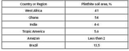
A more detailed classification can be found in the reference Classification and Cartography of Soils. 2020. (Presentation of the two main soil classification criteria SOIL TAXONOMY (USDA) and WRB SYSTEM, former FAO-UNESCO by Margarita M Alconada Magliano). Currently the most universally accepted denomination is plinthite and it is included with petroplinthite in the soils called plinthosols. Although some authors still call it laterite [7]. Plinthite differs from residual lateritic soils, among other things, in that it hardens irreversibly and two types of hardened soil can form; petroplinthite or pisolite. Petroplinthite is a continuous, fractured or broken sheet of connected, strongly cemented to hardened nodules or mottles. Pisolites are strongly cemented to hardened discrete nodules. Both petroplinthite and pisolites develop from plinthite by hardening. These soils are known as: Groundwater Laterite Soils, Perched Water Laterite Soils and Plintosols (Brazil); Sols gris lateritious (France); and Plenteous, Plintacualfes, Plintoxeralfes, Plintustalfes, Plintacuultes, Plintohumultes, Plintudultes, and Plintustultes (United States of America). [8-10]. It is estimated that there are 60 million hectares of Plintosols on the planet and they are associated with other residual soils such as Ferralsols, Acrisols and Alfisols [11-13]. The distribution of plinthite is very pronounced in West Africa, America, India and Western Australia, as can be seen in Table 2.
An approximate geographical distribution in South America and on the African Continent can be seen in figure 1.

The diagnostic criteria for a plinthic horizon are as follows:
1. Consist of at least 25 percent (by volume) of a humus-poor, iron-rich mixture of kaolinite clay with quartz and other diluents, which irreversibly changes to hardpan or irregular aggregates by exposure to repeated wetting and drying with free access to oxygen; and
2nd contain a minimum of 2.5 percent (by weight) citrate-dithionite extractable iron in the fine earth fraction, especially in the upper part of the horizon, or 10 percent in mottles or concretions;
2.b. contain a ratio between extractable iron in acid oxalate (pH 3) and extractable iron in citrate-dithionite less than 0.1017;
2 C. contain less than 0.6 percent (by weight) organic carbon;
2.d. have a thickness of 15 cm or more.
Field identification of a plinthic horizon is by red specks, usually in platy, polygonal, vesicular, or reticulate patterns. In permanently moist soil, plinthic material is generally not hard but firm or very firm and can be cut with a shovel. [14].
Plinthite forms in soil or subsoil layers with perennial moisture undergoing the following processes
1. Accumulation of sesquioxides by:
-removal of silica and bases, through advanced hydrolysis and discharge of weathered products, which results in an accumulation of sesquioxides resistant to weathering, quartz and kaolinite, or absolute accumulation of sesquioxides due to external enrichment,
2. Segregation of iron (specks) by alternate and consecutive reduction and oxidation.
Under water-saturated conditions, most of the iron is found as a mobile ferrous ion. Ferrous iron, when conditions turn dry, oxidizes and precipitates as ferric oxide and therefore does not redissolve when conditions turn wet again. Due to this process, mottles with polygonal or reticulated configuration are formed.

Figure 2: Inversion in a landscape with erosion. The hardening of plinthite exposed to the environment acts as a protective shield against erosion. [15-17].
Plinthite Hardening
In its natural, undisturbed form, plinthite is firm but can be cut with a shovel. But if for some reason the environment becomes dry, either due to a change in the level of the water table and/or due to climatic variations, the plinthite hardens irreversibly, becoming petroplinthite.
The hardening process involves the following processes:
• Crystallization of amorphous iron compounds in continuous aggregates of iron oxide minerals, especially goethite (FeOOH), and
• dehydration of goethite to hematite (Fe2O3) and, if present, gibbsite (Al2O3 .3H2O) to boehmite (Al2O3 H2O).
These processes take place after repeated wetting and drying, commonly after the removal of the forest or vegetation on the surface and/or the geological uplift of the land and/or climatic changes that lead to drier conditions, also due to lateral outcrop and exposure. weathering as in road trenches.
In both cases, plinthite or petroplinthite, contain sesquioxides (iron oxides and hydrated aluminum). Free iron is present as oxides, mainly lepidocrite and goethite (both FeOOH) and hematite; and aluminum appears as gibbsite and/or boehmite.
Older layers of petroplinthite contain more hematite and boehmite and fewer sesquioxides than plinthite. Free silica is present as quartz inherited from the parent material. The primary minerals disappear due to weathering and the dominant clay is well crystallized kaolinite.
All Plintosols have high iron and/or aluminum contents with variable proportions ranging from more than 80% iron oxides with little aluminum to about 40% of each. Most of these soils suffer from poor cation exchange properties and low base saturation, but there are exceptions such as Endoeutric soil units.
Soft plinthite is preferentially detected in rain forest areas, while skeletal and petroplinthic soils are more common in savannah environments (greater aridity).
Soft plinthite is dense, obstructing deep percolation of water and penetration of plant roots.
The specific density of petroplinthite varies from 2.5 to 3.5 Mg m-3, increasing when the iron content increases. Plintosols with a continuous iron plate at a shallow depth are not generally suitable for arable agriculture due to their low water storage capacity. However, it has been found that the morphology and hydrological behavior strongly depend on the type of land use related to agriculture and the type of crop. For example, arable or pasture soils showed poor water conductivity and hardened plinthite soil with coconut plantation and non-perennial crops such as manioc (cassava), below is more porous and does not restrict water circulation. On the other hand, the soil with pasture it experiences less erosion than arable or with coconut, which indicates, however, that careful management of these soils is required for their sustainability [18].
Recent studies of plinthic horizons and their transformations related to the different geological periods highlight the role of hydrology in the pedogenesis and transformation of iron minerals in tropical and subtropical soils. [19] and in the Mediterranean [20].
Plinthite or petroplinthite are extracted as a valuable material for the production of bricks (hence the origin of their name), by cutting massive petroplinthite; for use in foundations and walls in home and building construction, and as a coating for the improvement of roads and runways. In some cases, as ore for its content of Iron, Manganese and eventually Titanium.
Plinthite has been one of the most and best materials used for the construction of the Guarani Jesuit Reductions in the province of Misiones, Paraguay and Brazil, carried out by the Guarani under the orders of the Society of Jesus in the 16th century [21].
In particular, in the Province of Misiones, plinthite blocks were used in all 12 missions, the oldest being Loreto (1610) and San Ignacio Mini (1611) as shown in Table 3. Two types of stones were used in the construction of the walls of buildings, churches, workshops, houses, and others; the sandstone and the plinthite or itácuru. The less dense stone, easier to work and carve, are sandstone and they were used mainly in doors and ornamental carvings, and plinthite blocks were the structural resource for walls and bases, as shown in Figures 3a and 3b, respectively.


Figure 3: View of the existing constructions in the Jesuit Ruins. a) Portal next to the entrance of the church in San Ignacio Miní (probably intervened). b) wall adjoining the Church in the Ruins of Santa Ana. (Possibly original without intervention).
On the other hand, and four centuries later, the Misiones Provincial Road Directorate, recognizing the potential of plinthite, has used it as a sub-base for Provincial Coastal Road No. 2, section Concepción de la Sierra - San Javier, with a length approximately 50,000 m, a width of 10 m, an average thickness of 0.15 m and a swelling coefficient of 1.2, which is equivalent to a total of 90,000 m3 of plinthite.
Although some deposits near the missions from which the construction material was extracted are known, no systematic studies have been found regarding their locations, properties, processes and uses [22]. The reports of the literature made to date are referred to know, describe and analyze the physical, chemical and mechanical properties of the Plinthite oriented to the agronomic and forestry sectors, which limits the possibility of its use in other fields such as the road and the architectural.
In view of this, an exploratory investigation was carried out on some nearby deposits whose results can lay the foundations for more extensive and in-depth investigations with subsequent explorations, surveys and tests that may be necessary. Mainly those that contribute to establish and determine the specific properties for road use. On the other hand, the objective is also to revalue the Plinthite in order to promote its use in the reconstruction of the walls and arches of the Jesuit reductions, allegorical constructions and other constructions in general.
This report presents the location of deposits that have been used historically, both for the construction of the Jesuit reductions and for the construction of a section of Provincial Coastal Road No. 2 (Concepción de la Sierra-San Javier) and those found in the prospective search for other deposits that have not been exploited to date, their potencies were determined, that is, the volume of usable material, and their physical and chemical properties were determined.
EXPERIMENTAL PROCEDURES
Two types of experimental procedures were performed; one of field related to the location, description and determination of the usable volume of plinthite; and on the other hand, the procedures applied for the physical-chemical characterization of the material collected from some deposits selected for their different a priori characteristics and for their accessibility and proximity to the testing laboratories. Tests were carried out in the laboratory and outdoors, in order to determine the possible application and processing of the plinthite.
2.1 EXPLORATION AND CHARACTERIZATION OF THE DEPOSITS
Searches were carried out and deposits were located in the south of the Province of Misiones, particularly in the vicinity of the locations where the Jesuit reductions were built. The location of the deposits was carried out using satellite images provided by googleearth, accompanied by a visual survey in situ of the sector itself, where an estimated area is established in which there is a possibility of finding plinthite. Drilling was then carried out in places close to watercourses or where water springs can be seen up to an approximate maximum depth of 3 m. In other cases of deposits exposed by cross-section, the material was observed on the slopes. Samples were extracted from each zone, and its volume was estimated by determining the area and the average depth of the deposit. Of each stratigraphic profile obtained through the drills, a visual inspection of the materials that make up the profile is carried out, and the portions in which they contain the texture of the plinthite are tested; the amount of material extracted from each deposit for analysis is approximately 25 kg
2.2 CHARACTERIZATION OF THE SAMPLES.
The representative samples of each selected, explored and quantified deposit were used to carry out tests that would allow partial identification and classification of the material. For this, the granulometry was determined according to the following IRAM standards; the granulometric analysis was carried out using the IRAM 1505 standard and the test of the fine material that passes through the 75 (N°200) micron sieve by washing was carried out using the IRAM 1540 standard. The densities and humidity were determined in-situ by means of a Humboldt nuclear density and humidity meter, model HS-5001EZ, which has sealed emission sources, with double encapsulation in stainless steel of gamma radiation of Cesium 137 (intensity 10 mCi) and neutron radiation of Americium 241 Beryllium (40 mCi). The Fineness Modulus was calculated from the granulometry measurements as the sum of the retentates of the 3/8 sieve up to No. 100, divided by 100.
X-ray diffractometry (XRD) analyzes were performed to identify the components and the existence of crystalline phases in samples from three characteristic deposits. Analyzes were performed using a Cu anode, monochromator, 35 KV and 15 mA current. In addition, an attempt was made to identify the clay minerals in an amorphous state. To do this, these minerals were concentrated by dispersing them in water, allowing them to decant and subsequently a sample was taken, dried on a glass sample holder and identified by X-ray. The results found are confirmed by observation in a petrographic microscope.
2.3 HARDENNING TESTS
One of the characteristics that make plinthite a material for construction is the self-cementation that it develops during natural weathering as a consequence of the wetting and drying cycles. After carrying out the tests described in the previous point and with the objective of determining the conditions of the plinthite hardenning process, a test methodology proposed in the literature [23] was used, which consists of the following: a sample of approximately between 500 and 1000 gr is dried in an oven at 120ºC, then the sample is subjected to cycles of moistening and drying under the sun for 3 to 7 days, a time that depends on the ambient humidity and the intensity of solar radiation.
The specific cycling process applied in the present investigations consisted of wetting the different samples by spraying water. To each test tube, for each cycle, 500 gr of water was added by means of a sprayer (sprinkler). This instrument was used to moisten the samples with the aim of favoring water retention and minimizing immediate percolation in the samples subjected to drainage. The average spray speed adopted was 1 gr of water/s, being the estimated time to moisten each sample in each cycle equal to 500 s (8.3 minutes), each cycle lasted 7 days and is repeated for a period equal to or greater than 3 months. In the present investigation, the cycles were repeated for a period of between 6 to 9 months, then the samples are dried in an oven at 120ºC and their state of aggregation is determined.
The state of aggregation was determined by sieving using 3/8” sieves to 200 mesh number of 74 microns, and weighing both what was retained and what passed the sieve. Sieving was done before starting the wetting and drying period, and after it ended.
Two variants of the cycling process were used; one in which the samples are kept in an open rectangular container, and another in which the water is allowed to drain during the sun exposure cycles, for which the samples are placed in cylindrical plastic containers containing multiple perforations on the sides.
On the other hand, and in order to compare the results of the hardenning processes in the laboratory in its two variants, with and without drainage, with those of the samples subjected to natural weathering, samples were kept outdoors for 6 months in one of the located deposits (National RoadNo.105).
RESULTS Y DISCUSSION
3.1 EXPLORATION OF PLINTHITE DEPOSITS
Search of Plinthite deposits were performed in the southern area of the Province of Misiones, more precisely in the vicinity of the different Jesuit reductions. These are the deposits called San José, Apóstoles and Concepción de la Sierra. The new deposits found in the exploration carried out in this work are called: Provincial Coastal Road No. 2, Barrio el Progreso, National RoadNo.105 and Garupá. In the latter, due to its location, its dimensioning was not carried out. In addition, other deposits are known that are not included in this investigation, such as the one called Arroyo Maquina located at coordinates 27° 24'29.8" S, 55° 30'57.6" W and whose aerial photograph is shown in Figure 4, where an area of exposed plinthite can be observed, either due to the removal of vegetation and natural erosion or caused by the use of the land for agriculture. In addition, its proximity to the Ruins of Santa Ana, located in the town of the same name suggests that this depositwas probably used for its construction.

Figure 4: Deposit of the Machine Stream. (a) Agricultural and extractive activity of plinthite is observed. (b) Reduced view to show the proximity to the ruins of Santa Ana.
This deposit was also exploited by residents of the area for different uses, such as the construction of a house located nearby andat present abandoned.
A typical sample of petroplinthite is presented in Figure 5. Figure 5a corresponds to a surface exposed to the environment, where it can be seen the mottled ferruginous part. Figure 5b shows a view of a polished interior cut, where it can be seen grayer parts corresponding to the motes of iron oxide, which acts as a reinforcement of a natural compound, in a matrix of a softer material, also a considerable amount of macroscopic pores are observed.

Figure 5 : Fragment of itácurú or cemented plinthite collected from a superficial mantle. a) Surface exposed to the environmet. b) polished inner surface.
3.1.1 SAN JOSE DEPOSIT
The San José deposit is located in the Coordinates: 27° 46´ 32.2” S 55°46´ 24.8” W shown in Figure 6. The approximate capacity is 4 Has and through the drilling carried out, it was determined that it has an average depth of 2.5 m of homogeneous material resulting in a volume of 100,000 m3 of usable material. The deposit is located in a low-lying area, close to a watercourse, covered by grasslands. For much of the year the water table is very close to or above the ground surface. Due to this, the extraction of samples for their later analysis in the laboratory was carried out without difficulties.
On the nearby water course, there are blocks of petroplinthite [24], which have been dragged by the water or intentionally placed by the inhabitants of the area.

3.1.2 APOSTOLES DEPOSIT
The Apóstoles deposit (see Figure 7(a)) is located at coordinates 27°56´40¨ S and 55°47´69¨ W, in front of the recycling plant belonging to the Municipality of Apóstoles, in a place known as the Pozo de losAborigenes. It is located in a high area, far from a water course, and because it has been used recently it is not covered by vegetation.
For this reason, and also due to the action of rainfall, a large area of a very hard ferruginous crust (petroplinthite) is observed (see Figure 7(b)), with an approximate thickness of 30 centimeters, on a base of deep red soil.The approximate surface of this deposit is 2 hectares. Through the drillings carried out, an average depth of homogeneous material equal to 2.00 m has been determined. The usable volume of this deposit is 40,000 m3, less than the previous one but still considerable despite its exploitation over the centuries.

3.1.3 DEPOSIT OF CONCEPCIÓN DE LA SIERRA
The Concepción de la Sierra deposit is located at coordinates 27°55' S and 55°38' W, on the right of Provincial Road No. 2, (see Figure 8(a)), in the direction of Concepción de La Sierra. - San Javier. The approximate power of this deposit is 1.8 hectares. Through the drilling carried out, an average depth of homogeneous material equal to 2.80 m has been determined, which results in a usable volumen of plinthite of 50,400 m3.
It is located in a low area, close to a water course, and as in the previous case, because it has been used recently, it is not covered by vegetation (see Figure 8(b)). For this reason, and also due to the action of rainfall, a very hard ferruginous crust (petroplinthite) with an approximate thickness of 60 centimeters is observed.

3.1.4 DEPOSITPROVINCIAL COASTAL ROAD N° 2.
It is located on the right of the road (see Figure 9), in the direction of Concepción de la Sierra - San Javier, at coordinates 27°54'46¨ S and 55°26'36¨ W.
As mentioned above, it has been used for the construction of the sub-base of Provincial Coastal Road No. 2, with an average thickness equal to 15 cm. The approximate capacity of this deposit was estimated at 2.5 hectares. Through the surveys that have been carried out with drills, an average depth of homogeneous material equal to 2.80 m has been determined. resulting in a remaining usable volume of 70,000 m3.

3.1.5 DEPOSIT BARRIO EL PROGRESO
The Barrio El Progreso deposit is located at coordinates 27°28´39.51¨ S and 55°57´24.02¨ W (see Figure 10(a)). The approximate Surface area of this deposit was estimated at 1.8 hectares Through the surveys that have been carried out with drills, an average depth of homogeneous material equal to 1.40 m has been determined, resulting in a usable volumen of 25,200 m3 of plinthite. The characteristics of the plinthite can be seen in Figure 10(b).

3.1.6 NATIONAL HIGHWAY N° 105
On its trace, several sectors have been surveyed in which plinthite has been found; in progressive 6100, 6200 and 8000, being progressive 0 of the same road, the intersection with the By Pass roundabout. In this progressive 6200 location, the plinthite is found on the slope and lateral ditch of the left road, which has been excavated in August 2013. The characteristics of the place can be seen in Figure 11. This deposit was not dimensioned since, like the Garupá one, it is located in an unaccessible area for prospecting, considering that the road was built in the place. However, samples were taken for laboratory testing and also natural weathering tests with natural density and loose density were performed in the sampling site which was not altered during the test period.

Figure 11: Progressive Field 6,200; (a) Profile of the counter slope in the cementation process and (b) Slab in the natural cementation process.
3.1.7 DEPOSIT GARUPÁ
The Barrio Santiago of Garupa site is located at coordinates 27° 28' 16" S, 55° 50'32.88" W, which was nor dimensioned since it is located in a populated area. However, samples were taken for the tests in order to compare them with other deposits. At the time of sampling, the soil vegetation had recently been removed for the start of construction. In May 2021 the area is covered with houses, as can be seen by comparing Figures 12 a and 12 b. The deposit, due to the movement of soils carried out for the constructions, exposed the plinthite to weathering for longer time than that in the Road N° 105 deposit.

Figure 12: Location of the Garupá deposit; (a) at the time of sampling (2013) and (b) currently (2021).
3.2 SELF-CEMENTATION RESULTS
3.2.1 GRANULOMETRY AND CLASSIFICATION OF SAMPLES
Once the deposit exploration phase was concluded, the granulometric composition and natural humidity of each material extracted from the following previously described deposits were determined: San José, Apóstoles, C. de la Sierra, Ruta N” 2, El Progreso and Progresiva 6200 of Road No. 105.
The results of the granulometry of the samples taken in each of the 6 located and selected deposits are shown in Figure 13. There, a clear trend can be observed between two groups of samples; a finer one corresponding to the Ruta 105, El Progreso and San José deposits, and a thicker one corresponding to the Apóstoles, Ruta No. 2 and Concepción de la Sierra deposits.

The fine group corresponds to recently explored or exposed deposits such as RutaNo.105, which was exposed by excavations related to the construction of the Road and carried out in August 2013, and the samples collected a few months later; the sample from El Progreso, as can be seen in Figure 10 (b), is located in a humid area without being subjected to self-cementation cycles due to weathering, the same as the sample from San José deposit, which is located in a low, humid area and grass cover.
On the other hand, the samples from Apóstoles, Ruta 2 and Concepción de la Sierra correspond to deposits exploited over time; the first by the Guarani and the Jesuits, and recently by the municipality; the second for the construction of Road No. 2 and the third is exposed to natural cycles of self-cementation, presenting a layer of hard ferruginous petroplinthite on the surface without vegetation cover or humus. This indicates that the difference in fineness is a consequence of the cyclic process of natural wetting and drying.
3.2.2 EFFECT OF CYCLING ON THE GRANULOMETRY
As mentioned in the description of the methodology, three types of cycling experiments were carried out; two laboratory and one outdoors. In the laboratory, samples were cycled in which drainage was allowed in the drying cycles and others in which it was not. In the case of the in situ sample, cycling was natural in the open. The granulometric distribution and the Fineness Modulus were determined. In the first place, Table 4 shows the results of the Fineness Module in the seven tested samples corresponding to each of the located deposits. It includes the granulometry of the samples extracted from the Garupá deposit, identified as Garupá. In the table, it can be seen that this deposit has a high initial fineness value, so it is concluded that it suffered partial self-cementation.

Another observation that can be made from the data shown in the table is that the response of the cycling in the self-cementation of the plinthite is uneven. The results for the samples that have not been exposed, such as those from San José, increase the Fineness Modulus for both the case of cycles with and without drainage, by just over 30%. In the case of the sample from the El Progreso deposit, the effect of cycling with drainage is much greater than in the case of cycling without drainage. At the other extreme, the Garupá sample does not increase the Fineness Modulus for any of the cycles; with and without drainage. A significant increase in the fineness modulus is also observed in the Road 105 sample that underwent natural cycling outdoors.
The sample from El Progreso deposit was subjected to the two cycles; without drainage and with drainage. The results can be observed and compared in Figure 14. The difference in the granulometric changes between the treatments with and without drainage can be noted, where the percentage of grains smaller than 5 mm is much higher in the case of cycling with drain versus cycling without drain. Cycling without drainage practically did not modify the granulometric distribution with respect to the sample collected in the natural state.

Figure 14: Percentage that passes the sieve according to the mesh for the three samples from El Progreso.

However, no differences were observed in the granulometry in the Garupá sample after the processes with and without drainage, even with respect to the natural sample taken in the deposit, as can be seen in Figure 15. This indicates that this plinthite could have depleted its self-cementation capacity.
In order to investigate the reasons for the dispersion of behaviors in the self-cementation of the different samples subjected to the different processes, X-Ray Diffraction analyzes were performed on three samples corresponding to the San José, Garupá and El Progreso deposits. The synthesis of these analyzes in which the number of counts in the most important peaks of the identified substances is included in Table 5.
In the case of plinthite cementation, water obviously plays a fundamental role in some of the following aspects, as a solvent for products that can later react with the other plinthite constituents and/or as a carrier of soluble chemical elements or compounds own or external to the plinthite. For this reason, it is important to analyze the constitution of the different plinthites and identify the possible soluble constituents.
In the three samples in Table 5, a composition mainly made up of quartz is observed, the other components are detailed in percentages with respect to 100% of the quartz peak. Quartz is well known, it is made up of Silica (Si2O) with different crystalline structures, it is resistant to weathering and barely soluble through complex processes.
On the other hand, amorphous silica is soluble and its solubility increases with pH as shown in Figure 16 [25]. The solubility of quartz and amorphous silica in pure water at 25ºC are 6.0 mg/l and 115 mg/l, respectively [26].

The second most important mineral is Goethite with a maximum of 7.9% in the San José sample and a minimum of 2.3% in the El Progreso sample. Goethite is an iron (III) oxyhydroxide, with the formula α-FeO(OH), with a content of 63% iron, and can contain up to 5% manganese. Feroxyhyte and lepidocrite are polymorphs of this mineral, since they have the same composition and formula and different crystallization systems [27]. It is the most frequent iron oxide in soils followed by hematite; it is found in the crystalline state and is the least soluble iron oxide of all, in the following order of solubility:
Amorphous Fe(OH)3> soil Fe(OH)3>-Fe2O3maghemite>-FeOOHlepidocrite>-Fe2O3 hematite> goethite [28]. Both hematite and goethite form in soils from Fe in primary minerals and in organisms by weathering or decomposition, respectively. Once dissolved in the soil, the formation of one or another of the oxides depends on a competition involving local factors such as the amount of organic matter, microorganisms, temperature, available water, pH, mainly. Goethite gives the material its ocher color and hematite the intense red color that occurs in tropical areas where temperature and pH conditions favor its formation [29-30].
Neither of these two main components of plinthite, both quartz and goethite, act as a cementing agent given their properties and form part of its structure, consolidated by compounds that can be cemented. The cementable compounds must be in an amorphous state and after the cyclization processes crystallize joining the non-soluble components. The other materials identified in the three samples that can participate in the cementation process are Kaolinite, Clay, Feldspar and Silica, however none of these is present in the three samples. Therefore, the action of more than one mechanism that produces cementation is expected.
Kaolinite is a clay mineral, a part of the group of industrial minerals, with the chemical composition Al2Si2O5(OH)4. It is a stratified silicate type mineral, with a sheet of tetrahedrons linked through oxygen atoms in a sheet of alumina octahedrons. It is formed by a weathering mechanism of silicate minerals with an increase in pH due to the release of cations such as Na+ or Ca+2 from albite (NaAlSi3O8) or anorthite [31]:

These processes can increase the pH locally and dissolve part of the available amorphous silica as in the case of the El Progreso sample. In the case of the San José sample, this process has evidently already occurred due to the presence of kaolinite but not albite, anorthite or silica.
Unidentified Clay and Feldspar are found in the Garupá and El Progreso samples. Feldspars are a group of tecto and aluminosilicate minerals that correspond by volume to as much as 60% of the earth's crust. The composition of rock constituent feldspars corresponds to a ternary system composed of orthoclase (KAlSi3O8), albite (NaAlSi3O8) and anorthite (CaAl2Si2O8). Feldspars with a chemical composition between anorthite and albite are called plagioclases, while feldspars with a composition between albite and orthoclase are called potassium feldspars.
In all these processes, part of the amorphous and/or soluble compounds present that can participate in the self-cementation process have evidently already been used to a great extent in the three samples, either in the formation of kaolinite or feldspar. In the samples from Garupá and El Progreso clays have been identified and in the case of El Progreso silica, these plus other amorphous and minor clayey materials are those that can contribute to cementation. XRD analyzes plus petrographic microscopy confirm the presence of amorphous clay materials in less than 2% of the three samples. In the San José sample, the amorphous clay material is probably cryptocrystalline silica and some mineraloids such as allophane. Allophanite is an amorphous aluminum hydrosilicate from the group of phyllosilicates, with a variable composition Al2O3(SiO2)1.3-2.0·2.5-3.0 H2O. In the El Progreso sample, the amorphous material is probably nontronite and saponite. Nontronite is a silicate, of the alumino-phyllosilicate type with mica, sodium and iron sheets, hydroxylated and hydrated, and is part of the group of smectites with the chemical formula Na0.3(Fe3+2)2(Si,Al)4O10(OH)2·nH2O. Saponite is from the same group and consists of a hydroxylated and hydrated silicate of calcium, sodium, iron and magnesium. In the third sample identified as Garupá, the clays found are also part of the smectites, although they could not be identified within the group.
In other words, the amount of potentially self-cementing material is at least 2%, increasing in the case of the El Progreso sample due to the presence of silica and in the Garupá sample with a higher percentage of clays. The latter practically corroborated during the cycling tests, which after the cycling processes behaves like a coarse with clay that was pulverized instead of cemented, as can be seen in Figure 14 for small sieve sizes.
The cycling results show that the presence of clays and soluble silica are not sufficient to produce by themselves the cementation of the solid particulate components of the structure. Also that water is an essential part of this process and the need for permanent replacement of water indicates that its mere presence does not collaborate in cementation. In fact this is proved by the fact that the plinthite remains in that state due to the presence of water. In other words, water, in addition to its solvent capacity, can act as a carrier of external elements or compounds. In this regard, in studies carried out for Pampas soils as early as 1948 and more recently in 2005, cementation mechanisms are proposed in which water acts as a carrier of CO2 coming from the atmosphere and saturated during rains [32-33].
In the Patagonian soils, the water passes through and in its passage produces the transport of CO2, increasing the pH of the water tables. In our case, the CO2 transport process requires the replacement of a new CO2 load and therefore the water must be eliminated by drying and replaced by another load. This somehow explains the behavior of the El Progreso sample, which has silica in its composition and also the permanent replacement of water through drainage that produces a faster supply of CO2, resulting in a greater or faster hardening of the plinthite. In the case of the San José sample, the quantity and quality of the clay present eventually has little cementation capacity, either due to the quantity or quality of the clays present. This is clearly manifested in the Garupá sample where the remaining clay is not of quality and cementation capacity. In this aspect, the greater importance of siliceous cementation over carbonaceous cementation in the wear resistance of the material has been experimentally determined [32-33], which shows the importance of the constitution of clays in self-cementation processes.
SUMMARY AND CONCLUSIONS
Plinthite deposits were located and identified in the south of the Province of Misiones (Argentina), establishing their exploitation potential.
Granulometry tests were carried out to classify the samples of the deposits before and after the cycling process to which they were subjected, to determine the degree of self-cementation due to these processes. The cycling process consisted of wetting and drying the samples for 6 months. Three types of cycles were used; in the laboratory with and without water drainage; and natural outdoors.
The results indicate that two samples experienced the greatest hardening due to self-cementation; the El Progreso sample subjected to cycles with drainage and the Progresiva 6200 sample subjected to natural cycling, with similar processes and results. Samples subjected to natural self-cementation in the reservoir do not experience significant self-cementation, showing an exhaustion of this capacity.
The XRD analyzes show a composition of clays, in all cases less than 2%, which are important in the self-cementation process. Also, that the presence of silica produces a harder cementation and a greater effectiveness in the cycling process with drainage, probably due to the fact that it allows the transport of CO2, responsible for the cementation reactions that take place inside the plinthite.

