


Servicios Personalizados
Revista

Articulo
 Inglés (pdf)
 Articulo en XML
 Referencias del artículo
 Enviar articulo por email
Indicadores
-
 Citado por SciELO
Links relacionados
-
 Similares en
SciELO
Similares en
SciELO
Compartir

 Permalink
Revista de la Asociación Argentina de Sedimentología
versión impresa ISSN 1853-6360
Rev. Asoc. Argent. Sedimentol. vol.11 no.1 La Plata ene./jul. 2004
Clay mineral suites of the coastal mud belt associated with the changjiang river
Shu Gao1*, Xiaojing Zhou2 and Jianjun Jia1
1 Ministry of Education Key Laboratory for Coast and Island Development, Nanjing University, Nanjing 210093, China
2 Third Institute of Oceanography, State Oceanic Administration, Xiamen 361005, China
* Corresponding author (e-mail: shugao@nju.edu.cn)
Recibido: 06 de febrero de 2004
Aceptado: 05 de julio de 2004
Abstract: Clay minerals are often used as tracers to determine the range of the dispersal pattern of the mud and to identify the source of the materials. In quantitative material tracing, it is important to evaluate the changes in the content of the tracers during transport. Preliminary analysis of the clay mineral suites of five groups of samples collected along the Changjiang sediment transport pathways over a coastal mud belt indicates that the clay mineral suite is dominated by illite, chlorite and kaolinite, without significant changes in the relative percentages of montmorillonite, illite and kaolinite after leaving the Changjaing River mouth. An exception is associated with chlorite, possibly due to hydraulic sorting of clay particles. Thus, the major clay minerals including montmorillonite, illite and kaolinite may be used in material tracing for the region. However, because there are a number of factors that may alter the clay mineral suite (e.g. estuarine and diagenetic modifications), cautions should be taken when applying a mixing model to derive quantitative estimates of material supply from different sources: 1) the clay mineral suites of the coastal mud belt may be different from those within the Changjaing River estuary, with the latter being not suitable to be used as the fingerprint; and 2) in analyzing the sediment record in cores the effect of diagenetic processes must be evaluated.
Keywords: Clay minerals; Spatial distribution; Material tracing; Changjiang River sediment; East China Sea.
INTRODUCTION
Inner continental shelf areas receive a large amount of fine-grained sediment from rivers (Dronkers and Miltenburg, 1996). As a result, mud deposits are formed at sub-aqueous deltas and along the coastlines adjunct to the river mouth. For example, mud deposits are found near to the Changjiang River mouth and over the East China Sea coastal waters to the south of the river mouth (Sternberg et al., 1985; Milliman et al., 1985; Zhao et al., 1995; Qin et al., 1996). Examples of other mud deposits on the continental shelf associated with rivers of high fine-grained sediment discharges include those near to the Amazon River mouth (Sternberg et al., 1996; Allison et al., 2000) and the Gironde River mouth (Lesueur et al., 1996).
Clay minerals are often used as a tracer to identify the source of the materials that escape from the river delta and coastal mud areas (e.g. Griggs and Hein, 1980; Karlin, 1980; Yang, 1988; Park and Khim, 1990) and to determine the dispersal pattern or transport pathways of the bulk sediment (Petschick et al., 1996; Oliveira et al., 2002; Hein et al., 2003). In such studies, either a qualitative model (e.g. Naidu et al., 1995) or a quantitative one (e.g. Owens et al., 2000) is required. An assumption of the models, especially for quantitative models, is that the tracer itself, as a fingerprint, is stable during the transport of the bulk sediment. Although such an assumption is often applicable, clay minerals may be subjected to alterations after entering the marine environment in response to geochemical changes (Whitehouse and McCarter, 1958), flocculation (Eisma, 1993) and hydraulic sorting (Gibbs, 1977) during the transport. Hence, it is necessary to examine the stability of the tracer in marine environments in the exercise of identifying the material source.
The purpose of the present contribution is to analyze the clay mineral suites consisting of montmorillonite, illite, kaolinite and chlorite, which are derived from the Changjiang River and deposited over the coastal mud belt located to the south of the river mouth (Cai, 1982; Xie et al., 1984; Jin, 1992). On such a basis, the variability of the clay mineral suites and the suitability of using them as the tracing fingerprint are discussed.
THE STUDY AREA
The coastal mud belt in consideration has a length of around 600 km (Fig.1); it is located on the inner continental shelf of the East China Sea, extending from the southern end of the Changjiang River sub-aqueous delta towards the south, passing through the coastline of Zhejiang Province and reaching the coast of northern Fujian Province (Li et al., 1983; Jin, 1992). The width of the coastal mud belt decreases from the north towards the south (Fig.1), with a maximum Holocene sequence thickness of more than 30 m (Dai, 1988). In the north, the mud deposit extends into the Hangzhou Bay, with the fine-grained sediment being supplied by the Changjiang River. The large size of the mud deposit is understandable, because its material supply is provided by the Changjaing River, the largest river in China (with a drainage area of 180×104 km2 and a sediment discharge of around 5×10⁸ tn yr-1). Along the rocky coast of Zhejiang and Fujian Provinces there are a number of small rivers, but their sediment input consists mainly of sandy materials (Jin, 1992).
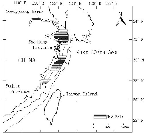
Figure 1. Location of the coastal mud belt associated with the Changjiang River (bathymetry in metres)
Figura 1. Ubicación del cinturón de fango costero asociado con el río Changjiang River (batimetría en metros)
The tides are mainly regularly semidiurnal in character, except in the Hangzhou Bay where the tides are irregularly semidiurnal, with a maximum tidal range of 5-8 m (Jin, 1992). Thus, tidal currents are strong in shallow water areas (e.g. in straits between islands and coastal embayments, maximum tidal currents of more than 3 m s-1 have been observed). Because of the combined effect of tidal action and Changjiang River sediment supply, tidal flats are formed extensively along the rocky coastlines, forming a unique coastal landform type (Li et al., 1987). Another important factor for the suspended sediment transport towards the south is the shelf current known as the «Zhejiang-Fujian Coastal Current», which flows from the north to the south in the offshore waters with an enhanced intensity during the winter season (Qin et al., 1996).
METHOD
Seabed sediment sampling was carried out in Hangzhou Bay in December 2001 and along the Zhejiang coast in November 2002 (for sampling sites, see Fig. 2). The sampling areas covered approximately the northern half of the coastal mud belt. For the first sampling campaign, 9 short cores were collected from the Hangzhou Bay (shortened as HZB in the following text) mud areas by the Second Institute of Oceanography, State Oceanic Administration; sub-samples were taken from the top 2 cm of the cores for the present study. For the second sampling campaign, seabed sediment samples were collected along four profiles located at Zhoushan (shortened as ZS in the following text), Xiangshan (XS in short form), Jiaojiang (JJ) and Dongtou (DT), respectively. These profiles extended from the offshore areas towards the 25 m bathymetry. For each of the profiles, the samples were numbered according to their positions, with the smallest number being the closest to the shoreline. In total, 25 samples from the mud deposits were used for the present study.

Figure 2. Seabed sediment sampling sites of the coastal mud belt
Figura 2. Sitios de muestreo de los sedimentos de fondo en el citurón de fango costero.
In the laboratory, grain size analysis was undertaken using a Mastersizer 2000 laser particle sizer (product of Malvern Co., UK), with the bulk sediment being dispersed in the 0.05 N sodium hexametaphosphate (NaPO3) solution (for detailed pre-treatment procedures, see Cheng et al., 2001and Sun et al. 2001). The range of measurements is 0.02~2000 ì m for this instrument. Subsequently, the formulae introduced by McManus (1988) were used to calculate the grain size parameters (i.e. mean, sorting coefficient and skewness).
The clay minerals were analyzed with the X-ray diffraction method, using the < 2 ì m fraction of the sediment and following the procedure described in Hardy and Tucker (1988) and Zhou et al. (2003). The fraction of < 2 ì m was obtained by pipette operation, on the basis of the Stokes law of particle
settling, and filtration. The material retained on the filter was dried and glycolated. The instrument used was a D/max-RB diffractometer, using CuKá radiation (40 K V, 100 mA). Continuous scans were run between 3º and 33º 2è, with a speed of 5º/min. In the X-ray diffractograms obtained, the presence of montmorillonite (the 17 Å peak), illite (the 10 Å peak) and kaolinite and chlorite (the 7Å peak) was identified. A problem associated with the analytical procedure is that the 002 kaolinite and 004 chlorite peaks were too close; however, due to the limitations under the present laboratory conditions, it is difficult to undertake additional analysis. Thus, the contents of kaolinite and chlorite were determined on the basis of the 002 (3.56-3.58Å) and 004 (at 3.54Å) diffraction values, respectively. The relative percentages of these four clay minerals were determined using the weighting factors of Biscaye (1965) with the sum of the four contents being 100%.
RESULTS
The grain size distribution patterns are highly similar over the mud belt (Fig. 3) dominated by silts. The types of the bulk sediment fall into clayey silt or silty clay according to the classification scheme of Shepard (1954). These characteristics are indicative of a single, stable sediment source.

Figure 3. Representative grain size distribution histograms of the seabed sediment
Figure 3. Histogramas representativos de la distribution de tamaños de granos del sedimento de fondo
The relative percentages of the four clay minerals (montmorillonite, illite, kaolinite and chlorite) are listed in Table 1, together with the mean grain size data. Generally, the clay mineral suite is dominated by illite (around 60 %), chlorite (around 20 %) and kaolinite (around 17 %). These results are qualitatively consistent with the studies by Zhu (1985) and Yang (1988) in that the content of illite is the highest and that of montmorillonite is the lowest in the Changjiang River sediment. Figure 4 shows the X-ray diffraction diagrams of representative samples from the five locations (note that in the graphs there are no double peaks for kaolinite and chlorite; the values listed in Table 1 were read from the digital record obtained in the analysis, rather than from the figures).
Table 1. Mean grain sizes and relative clay mineral contents of the samples
Tabla 1. Granulometría media y contenido relativo de minerales de arcilla en las muestras


Figure 4. Typical X-ray diffractograms of clay minerals from the surficial sediment samples off the Zhejiang coast
Figura 4. Típicos difractogramas de rayos X de arcillas de sedimentos superficiales costa afuera de Zhejiang
Satistical analysis for the data listed in Table 1 shows that the mean grain size and the clay mineral contents of the five profiles are close, with relatively small standard deviations (Table 2). In order to examine the degree of similarity between the clay mineral suites of different profiles, t-tests (Berry and Lindgren, 1990) were conducted for the four types of clay minerals and for all the combinations of any two profiles. For example, the mean and standard deviation of the nine kaolinite content values from HZB were compared with those from ZS to derive the t-score, to tell the degree of similarity between them. The results derived from the statistical analyses indicate that, at the 0.05 significance level, there is a high degree of similarity for montmorillonite, illite and kaolinite contents between any two data sets. However, at the same significance level, the chlorite content data did not pass the test for comparisons between ZS and XS, JJ or DT, though there are still high similarities between the remainder. This result may indicate that the chlorite content at ZS is different from those at the locations in the south.
Table 2. Mean grain size and clay mineral content with the standard deviation (in brackets)
Tabla 2. Granulometría media y contenido de arcillas con su desviación estándar (en paréntesis)

DISCUSSION
The analytical results described above show that there are no significant changes in the relative percentage for montmorillonite, illite and kaolinite after leaving the Changjaing River mouth. An exception is associated with chlorite, which has a localized difference at Zhoushan (ZS). It cannot be excluded that such a difference is caused by the limitations in the analytical procedure (in the future, improved analysis should be undertaken to determine the kaolinite and chlorite contents more accurately). On the other hand, the physical and chemical properties of chlorite may play a role. This clay mineral has a larger density (i.e. around 2500 kg m-3) than the other clay minerals (i.e. 2100-22500 kg m-3) (Gibbs, 1977), and it has a relatively low chemical stability in aqueous environments (Oliveira et al., 2002). Thus, it is possible that the content of chlorite is influenced by local physical-chemical factors. For instance, because tidal currents are strong in the Zhoushan (ZS) waters (Jin, 1992), hydraulic sorting may take place to concentrate the chlorite particles. Notwithstanding this exception, the present study indicates that the major clay minerals including montmorillonite, illite and kaolinite have relatively stable contents and, therefore, they can be applied to the tracing for material source of the region. However, there are other conditions that should be satisfied for such applications: caution should be taken to account for the estuarine and diagenetic modifications to the clay mineral suites.
This concern is raised because the stability status of clay minerals in other systems has been shown to differ from the Changjiang sediment system. For examples, the clay mineral contents have significant spatial variability for the Pamlico River (Edzwald and O'Melia, 1975) and the Amazon River (Gibbs, 1977).
Three factors have been proposed to explain the observed spatial variability of clay mineral contents. Firstly, clay minerals may be subjected to chemical alterations. Experiments carried out by Whitehouse and McCarter (1958) have indicated that montmorillonite can be transformed into illite in seawater on decadal time scales. This may explain the decrease of the montmorillonite content and the increase in the illite content in the seaward direction for the Amazon River sediment system (Gibbs, 1977). Recently, it has been found that on decadal time scales illite and chlorite can be diagenetically modified if geochemical conditions of oxidization/reduction and material cycling permit (Velde and Church, 1999). Secondly, differential flocculation of the clay minerals may occur. Clay particles do not flocculate in freshwater but they flocculate in saline or brackish waters (Van Olphen, 1963; Eisma, 1993). Laboratory experiments undertaken by Whitehouse et al. (1960) demonstrated that different clay minerals respond to flocculation in different way, especially in low salinity waters. In marine environments, differential flocculation may be further influenced by differences in pH values, as indicated by the study of Ravisangar et al. (2001). The differential flocculation has been adopted to explain the clay mineral distribution patterns in estuaries and on the continental shelf (Edzwald and O'Melia, 1975). Finally, sorting of clay particles can occur during transport and accumulation. Since the four clay minerals have different dry densities and, for the Amazon River, the particles have different sizes, hydraulic sorting has a significant influence (Gibbs, 1977). As a result, the heavier, larger particles would settle at an earlier stage than the lighter, smaller particles after leaving the river mouth, causing seaward changes in the composition of the clay mineral suite.
The environment from which the sediment samples were collected does not appear to allow these factors to have the effects described above. Firstly, strong tidal currents cause frequent resuspension of bottom sediment and mixing of suspended sediments within the water column. Furthermore, rapid sediment transport takes place in response to the combined action of tidal currents, waves and shelf currents. The Zhejiang-Fujian Coastal Current has a speed of 0.1-0.2 m s-1 in the winter (Qin et al., 1996); this means that the sediment will move over a distance of 260-520 km within a month in the winter. In such a dynamic environment, the surficial sediment represents newly discharged material from the river; the time is too short for diagenetic changes to occur. It has been reported elsewhere that, in marine environments with strong hydrodynamic influences, the spatial distribution of clay minerals results mainly from physical processes, rather than diagentic processes (Gingele et al., 2001; Oliveira et al., 2002; Hein et al., 2003). Secondly, the Zhejiang coastal waters are associated with relatively high salinity (generally > 20) and pH (often > 8) values (Anonymous, 1988; State Oceanic Administration, 1998). Hence, differential flocculation cannot be intense enough to form flocs of different sizes for the different types of clay minerals. Finally, although the grain size characteristics of the clay mineral particles are not known, the grain size distributions of the seabed sediment over the mud belt (cf. Fig. 3 and Table 2) do not show remarked hydraulic sorting. With regard to density sorting, perhaps the content of chlorite at Zhoushan (ZS) is relevant, but further studies are required to confirm this hypothesis.
The conditions discussed above indicate that the clay mineral suites of the coastal mud belt represent the characteristics of the materials leaving the mouth of the Changjiang River, which have not yet been subjected to diagenetic changes. Hence, the relative percentages of montmorillonite, illite and kaolinite material can be used as an end-member (or fingerprint) for material tracing only for that part of Changjiang River materials. It is worth pointing out that, when applying a mixing model to derive quantitative estimates of material supply from different sources, the clay mineral composition within the Changjaing River estuary may be used as an end-member equivalent to that of the coastal mud belt after the effect of estuarine modifications being added, and the effect of diagenetic modifications must be evaluated in analyzing the sediment record in cores.
Acknowledgements: The authors wish to thank Mr Chen Xi-tu (Second Institute of Oceanography, State Oceanic Administration), who helped with the sampling in the Hangzhou Bay, Dr Gao Jian-hua (Nanjing University), who participated in the sampling off the Zhejiang coast, and Mr Yang Yang (Nanjing University), who helped with the preparation of one of the figures. The analysis of the clay minerals was completed by the Centre for Analyses, China Ocean University, and the grain size analysis was undertaken at the Ministry of Education Key Laboratory for Coast and Island Development, Nanjing University. Dr Graciela Mas and Dr Eduardo Dominguez are thanked for their critical comments on the clay mineral determination. The study is financially supported by the Natural Science Foundation of China through a grant awarded to SG (No. 40231010).
REFERENCES
1. Allison, M. A., M. T. Lee, A. S. Ogston and R. C. Aller, 2000. Origin of Amazon mudbanks along the northeastern coast of South America. Marine Geology 163:241-256. [ Links ]
2. Anonymous, 1988. Report on the environmental characteristics and natural resources of the Zhejiang coastal zone. China Ocean Press, Beijing. (In Chinese) [ Links ]
3. Berry, D. A. and B. W. Lindgren, 1990. Statistics: theory and methods. Brooks/Cole, California. [ Links ]
4. Biscaye, P. E., 1965. Mineralogy and sedimentation of recent deep sea clay in the Atlantic Ocean and adjacent sea and oceans. Bulletin of the Geological Society of America 16:803-832. [ Links ]
5. Cai, A. Z., 1982. Dispersal of the sediment from the Changjiang River. Acta Oceanographica Sinica 4:78-88. (In Chinese) [ Links ]
6. Cheng, P., S. Gao and X. S. Li, 2001. Evaluation of a wide range laser differential grain size analyser and comparison of its results with pipette and sieving methods. Acta Sedimentologica Sinica 19:449-455. (In Chinese, with English abstract) [ Links ]
7. Dai, Z. H. (editor), 1988. Report on the multi-disciplinary investigations of the Zhejiang coastal zone and natural resources. China Ocean Press, Beijing, 485pp. [ Links ]
8. Dronkers, J. and A. G. Miltenburg, 1996. Fine sediment deposits in shelf seas. Journal of Marine Systems 7:119-131. [ Links ]
9. Edzwald, J. K. and C. R. O'Melia, 1975. Clay distributions in recent estuarine sediments. Clays and Clay Minerals, 23, 39-44. [ Links ]
10. Eisma, D., 1993. Suspended Matter in the Aquatic Environment. Springer-Verlag, Berlin, 315pp. [ Links ]
11. Gibbs, R. J., 1977. Clay mineral segregation in the marine environment. Journal of Sediment Petrology 47:237-243. [ Links ]
12. Gingele, F. X., P. De Deckker and C. -D. Hillenbrand, 2001. Clay mineral distribution in surface sediments between Indonesia and NW Australia - source and transport by ocean currents. Marine Geology 179:135-146. [ Links ]
13. Griggs, G. B. and J. R. Hein, 1980. Sources, dispersal, and clay mineral composition of fine-grained sediment off central and northern California. Journal of Geology 88:541-566. [ Links ]
14. Hein, J. R., J. S. Dowling, A. Schuetze and H. J. Lee, 2003. Clay-mineral suites, sources, and inferred dispersal routes: Southern California continental shelf. Marine Environmental Research 56:79-102. [ Links ]
15. Hardy, R. and M. E. Tucker,1988. X-ray diffraction. In: Tucker, M. E. (Ed.), Techniques in Sedimentology. 191-228 Blackwell, Oxford. [ Links ]
16. Jin, X. L. (editor), 1992. Marine Geology of the East China Sea. China Ocean Press, Beijing. [ Links ]
17. Karlin, R., 1980. Sediment sources and clay mineral distributions off the Oregon coast. Journal of Sedimentary Petrology 50:543-560. [ Links ]
18. Lesueur, P., J. P. Tastet and L. Marambat, 1996. Shelf mud field formation within historical times: examples from offshore the Gironde estuary, France. Continental Shelf Research 16: 1849-1870. [ Links ]
19. Li, S. Z., F. Y. Zhang and X. C.Wang, 1983. A preliminary analysis of the formation of East China Sea sediments. Acta Oceanographica Sinica 5:753-765. (In Chinese) [ Links ]
20. Li, Y., L. R.Zhang and Q. C. Xie, 1987. Periodical development of the intertidal mudflat at Damutu, Xiangshan, Zhejiang. Acta Oceanographica Sinica 9:725-734. [ Links ]
21. McManus, J., 1988. Grain size determination and interpretation. In: Tucker, M. (Ed.), Techniques in Sedimentology, 63-85, Blackwell, Oxford. [ Links ]
22. Milliman, J. D., R. C. Beardsley, Z. S. Yang and R. Limeburner, 1985. Modern Huanghe-derived muds on the outer shelf of the East China Sea: Identification and potential transport mechanisms. Continental Shelf Research 4: 175-188. [ Links ]
23. Naidu, A. S., M. W. Han, T. C. Mowatt and W. Wajda, 1995. Clay minerals as indicators of sources of terrigenous sediments, their transportation and deposition: Bering Basin, Russian-Alaskan Arctic. Marine Geology 127:87-104. [ Links ]
24. Oliveira, A., F. Rocha, A. Rodrigues, J. Jouanneau, A. Dias, O. Weber and C. Gomes, 2002. Clay minerals from the sedimentary cover from the Northwest Iberian shelf. Progress in Oceanography 52:233-247. [ Links ]
25. Owens, P. N., D. E.Walling and G. J. L. Leeks, 2000. Tracing fluvial suspended sediment sources in the catchment of the River Tweed, Scotland, using composite fingerprints and a numerical mixing model. In: Foster, I. D. L. (Ed.), Tracers in Geomorphology, 291-308 J. Wiley, Chichester. [ Links ]
26. Park, Y. A. and B. K. Khim, 1990. Clay minerals of the recent fine-grained sediments on the Korean continental shelves. Continental Shelf Research 10:1179-1191. [ Links ]
27. Petschick, R., G. Kuhn and F. Gingele, 1996. Clay mineral distribution in surface sediment of the South Atlantic: sources, transport, and relation to oceanography. Marine Geology 130:203-229. [ Links ]
28. Qin, Y. S., Y. Y. Zhao, L. R. Chen and S. L. Zhao, (editors), 1996. Geology of the East China Sea. Science Press, Beijing. [ Links ]
29. Ravisangar, V., B. M. Brouckaert, A. Amirtharajah, and T. W. Sturm, 2001. The role of solution chemistry in the stability and detachment of cohesive kaolinite particles. Water Supply 1: 25-32. [ Links ]

